Browse Listings in Asia > Holy Land & Jerusalem
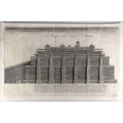
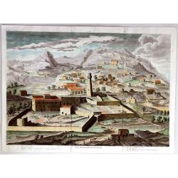
The Prospect of the North Side of the Temple.
A fine copper engraved religious print from a Bible in 1762. It features the north side view of the temple of Solomon. Each of the different levels of the temple are lab...
Place & Date: London, 1762
Selling price: $32
Sold in 2019
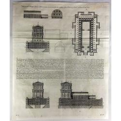
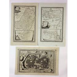
These are the Things Wherin Solomon Was Instructed for the Building of the House of God, II Chronicles, Chapter III, Verse 3.
A fine copper-engraved religious print from a Bible in 1762. It features pictures of all sides of the temple with labels and explanations in the key at the center.
Place & Date: London, 1762
Selling price: $23
Sold in 2018
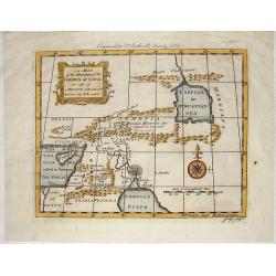
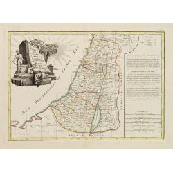
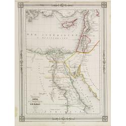
A Map of the Situation of the Garden of Eden as Also of Mouth Ararat.
This interesting map shows Gordion Mountains where the ark is supposed to have rested. It was engraved by J. Flyn for Dr. Southwell's Family Bible.
Place & Date: London, 1763
Selling price: $125
Sold in 2014
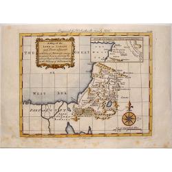
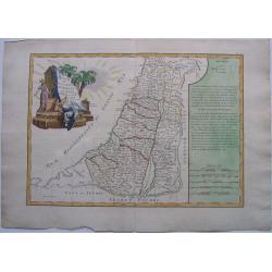
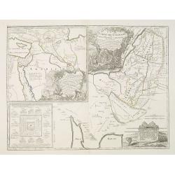
A Map of the Land of Canaan and Parts Adjacent.
"At the time of Abraham's coming to sojourn the rein, showing the several people & places mentioned in the history of the Patriarchs".Engraved by G. Rollos ...
Place & Date: London, 1763
Selling price: $125
Sold in 2014
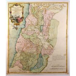
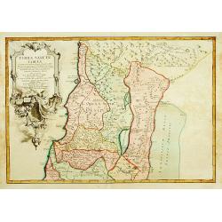
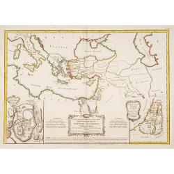
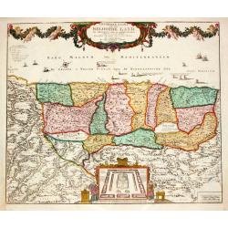
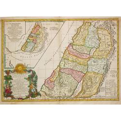
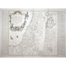
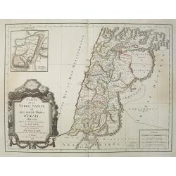
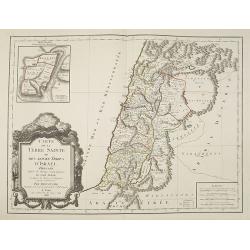
Terrae Sanctae Tabula e Scripturae Sacrae, Flavii Josephi ....
A large, striking example of De L'Isle's 1762 decorative map of the Holy Land, including Israel and Palestine. Printed in two sheets, it covers the region from Gaza and t...
Place & Date: Paris, 1763
Selling price: $170
Sold in 2015
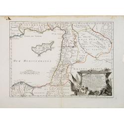
Carte Générale de la Syrie / Palestine / Isle de Chypre. . .
A very fine map of Syria, Palestine, and the island of Cyprus with part of the surrounding countries, prepared for the understanding of the history of the Crusades by Gui...
Place & Date: Paris, ca. 1764
Selling price: $450
Sold
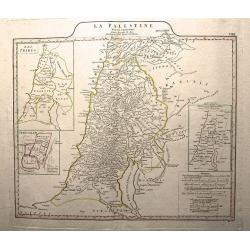
La Palestine.
This is an authentic Antique Map of Palestine by Jean Baptiste d’Anville. The map was published out of Paris in 1767.This informative map shows the area of Palestine an...
Place & Date: Paris, 1767
Selling price: $85
Sold in 2015
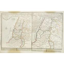
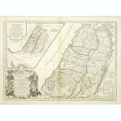
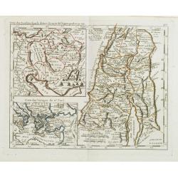
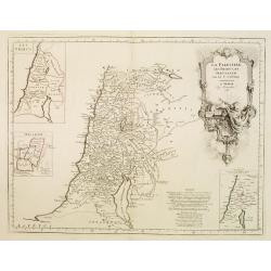
Descriptio Acurata Terrae Promissae Per Sortes XII.. & Terre Sainte Moderne.
2 maps on 1 sheet. To the left a very attractive map of Palestine divided among the 12 Tribes on both sides of the Jordan, after Philippe de La Rue. At the right hand sid...
Place & Date: Paris, 1770
Selling price: $150
Sold in 2013
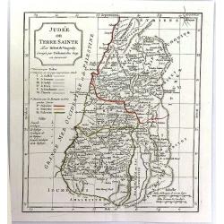
ISRAEL, - Carte des douze Tribus D'....
1770 Bonne Map of Israel showing the Twelve Tribes A fine engravedantique maptitled'_Carte des Douze Tribes D'ISRAEL,taken from 'Atlas Moderne ou collection de C...
Place & Date: Paris, 1770
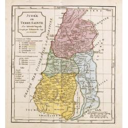
Carte des douze tribus d'Israel..
A finely engraved map depicting the division of the Holy Land into twelve tribes after Bonne.
Place & Date: Paris, 1771
Selling price: $120
Sold in 2014
Carte de la terre des Hébreux / La Monarchie des Hébreux..
Two maps of the Holy Land on one sheet. Engraved by the master G.Delahaye and prepared by N.Sanson. In title cartouche lower left Moses and Aaron.
Place & Date: Paris, 1778
Selling price: $300
Sold
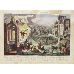
Vue de la Ville Bethlehem. . .
So-called optical print of the city Bethlehem in Israel, showing an angel announcing the birth of Jesus Christ. One of the well-known and earliest publishers of optical p...
Place & Date: Paris, 1780
Selling price: $120
Sold in 2014
Set of Three Bible Engravings by Condor.
A set of 3 bible copper engravings from "Mr. Priestley's Evangelical Family Bible". Two of the maps have two maps on one sheet so there are a total of four maps...
Place & Date: London, ca. 1780
Selling price: $130
Sold in 2017
Carte de la Palestine ou Terre Sainte.
A pleasant map of the Holy Land from Sidon to Gaza and inland to the Arabian Desert. The map is divided into the Tweve Tribes and a key identifies royal villages and Levi...
Place & Date: Paris, 1780
Selling price: $35
Sold in 2019
Iudaea.
Rare map of Holy Land, from "Atlante Novissimo ad uso Dei Giovani Studiosi Contenuto In Carte XXVII.", published by Giovanni Zempel in Rome, ca. 1780.The map is...
Place & Date: Rome, 1780
Selling price: $100
Sold in 2018
Camp des Israelites dans le désert. . . / La Judée ou Terre Sainte divisée en douze tribus. . . Carte des Voyages de St. Paul.
This antique map shows detailed the Holy Land, prepared by Nolin and published by L.J. Mondhare for his Atlas Général a l'usage des colleges et maisons d'education.. Lo...
Place & Date: Paris, 1781
Selling price: $80
Sold in 2013
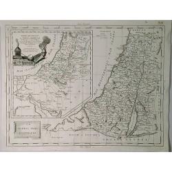
TERRAE SANCTAE TABULA e scripturae sacrae?
Map of the Holy Land on both sides of the Jordan, divided among the Tribes and according to the division into provinces at the Roman time. The shore line runs from Sidon ...
Place & Date: Paris 1771-1783
Selling price: $200
Sold
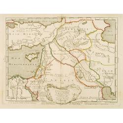
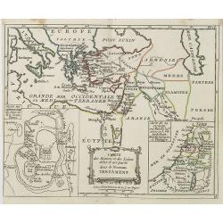
Carte générale pour servir à l'Intelligence de l'Histoire Sainte..
Fine map of the Middle East, including the Holy Land, Cyprus, Iran and Irak, etc.Philippe Buache was one of the most active proponents of the so-called school of theoreti...
Place & Date: Paris 1783
Selling price: $60
Sold
Carte des douzes Tribus d' Israel.
Jean Lattré, Paris-based engraver and publisher. Worked with Robert de Vaugondy, J. Janvier and R. Bonne. " Atlas Monderne', 1771, 1783 , 1793. Rigobert Bonne (1727...
Place & Date: Paris, 1783
Selling price: $260
Sold
Carte des Regions et des Lieux dont il est parlé dans le Nouveau Testament..
A map of the near East at the time of Christ. Ornated with a decorative title cartouche. Boundaries outlined in hand color.Inset plan of Jerusalem in the bottom left corn...
Place & Date: Paris ca 1783
Selling price: $70
Sold
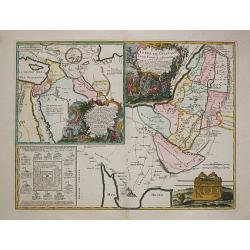
Camp des Israelites dans le désert à la sortie de l'Egipte . . . / La Judée ou Terre Sainte. . . / Carte des voyages de St. Paul.
Three maps on one sheet. The largest map showing Palestine north of the Death Sea, dived in 12 Tribes. The left a map of the travels of St. Paul and a detailed map of the...
Place & Date: Paris, 1783
Selling price: $400
Sold in 2008
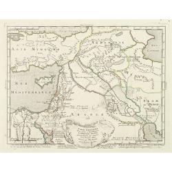
Carte générale pour servir à l'Intelligence de l'Histoire Sainte..
Fine map of the Middle East, including the Holy Land, Cyprus, Iran and Iraq, etc.Philippe Buache was one of the most active proponents of the so-called school of theoreti...
Place & Date: Paris, 1783
Selling price: $200
Sold in 2010
![[Two maps] Terrae Sanctae Tabula. . .](/uploads/cache/42840-250x250.jpg)
[Two maps] Terrae Sanctae Tabula. . .
Attractive map of the Holy Land, orated with a decorative title cartouche. Boundaries outlined in hand color.Prepared by Le Sieur Janvier, Jean Denis [Robert], French geo...
Place & Date: Paris, ca 1783
Selling price: $38
Sold in 2019
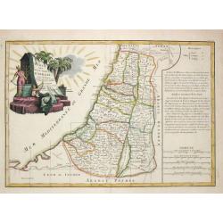
La Palestine, les Tribus, et Jerusalem par le Sr. d'Anville.
Map of Palestine on both sides of the Jordan, the shore line running from Sidon to Rhinocorura (El-Harish).The Jordan river between teh Lake of Tiberias and the Dead Sea ...
Place & Date: Venice, 1776 - 1784
Selling price: $130
Sold in 2023
La Judée ou Terre Sainte divisée en ses douze Tribus..
A finely engraved and uncommon map depicting the division of the Holy Land into twelve tribes. In upper left hand corner inset map of land of Canaan.Venetian edition of G...
Place & Date: Venice, 1776 - 1784
Selling price: $350
Sold in 2008
Carte des Régions et des Lieux dont il est parle..
Covers the region of the eastern Mediterranean through the Caspian Sea, showing the region described in the New Testament. Inset plans of Jerusalem and Judea. Three decor...
Place & Date: Paris 1785
Selling price: $140
Sold
Terra di Canaan & Le Dodeci Tribu D'Isdraele.
An interesting Holy Land map with two parts, Israel with Canaan inserted to the top left. Filled with details of roads, towns and pictorial topography. The map features t...
Place & Date: Venice, 1785
Selling price: $75
Sold in 2019
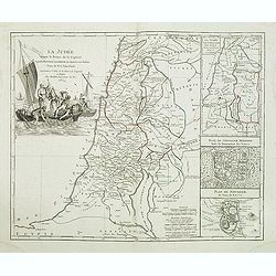
La Judée depuis le Retour de la Captivité, . . .
Decorative map of the Holy Land, with large insets of Ancient and Modern Jerusalem and the Holy Land at the time of the domination by the Turks. Large striking cartouche....
Place & Date: Paris, Boudet, 1786
Selling price: $60
Sold in 2011
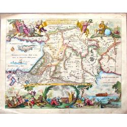
Beschryvinge Van Den Oorsrong de Volkeren, Uit de Drie Sonen van Noah na den Sondvloed.
Striking hand-colored Dutch Bible map covering the region from the Mediterranean through to the Persian Gulf. the map depicts Abraham's route from Ur, Noah's arc, the wan...
Place & Date: Amsterdam, 1787
Selling price: $349
Sold in 2015
Generaale Kaart van het Beloofde Land.
Jan Berend Elwe. Amsterdam-based publisher. Published a pocket-atlas of the Netherlands (1786) and of Germany (1791). Publised in 1792 a folio-atlas with 37 maps.
Place & Date: Amsterdam, 1792
Selling price: $400
Sold
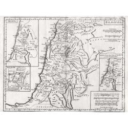
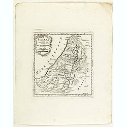
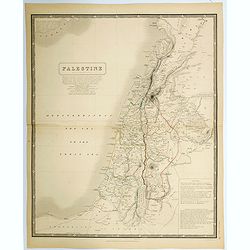
Palaestina.
Highly detailed map of the Holy Land with insert of Tribus and Jerusalem and distance scale.
Place & Date: London, 1795
Selling price: $80
Sold in 2012
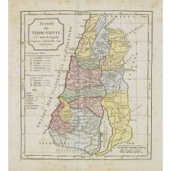
Judee ou Terre Sainte.
Copper engraved, hand-colored map of present day Istael and Jorden. It shows the 12 tibes, the six provinces under Herod and the 3 Roman provinces. The map was engraved b...
Place & Date: Paris, 1795
Selling price: $89
Sold in 2017
TERRE de CHANAAN ou Terre Promisse a Abraham Et sa Posterité./ CARTE des VOIAGES D' ABRAHAM
Charles François Delamarche (1740-1817), Paris-based geographer and publisher, successor to Didier Robert de Vaugondy after his death in 1786.A map of Palestine and a ma...
Place & Date: Paris, 1797
Selling price: $225
Sold
CARTE DE LA TERRE DES HEBREUX ou ISRAELITES / LA MONARCHIE DES HEBREUX SOUS SALOMON.
Charles François Delamarche (1740-1817), Paris-based geographer and publisher, successor to Didier Robert de Vaugondy after his death in 1786.A map of Palestine as divid...
Place & Date: Paris, 1797
Selling price: $325
Sold
Terre de Chanaan, ou Terre promise à Abraham et à sa Posterité . . .
Two maps on one sheet. With a map of Palestine and a map of the Near Eas with a title cartouche "Carte des voiages d'Abraham faits par l'ordre de Dieu, en Asie et en...
Place & Date: Paris, ca. 1797
Selling price: $100
Sold in 2010
Judée ou Terre Sainte.
Map of the Holy Land, Judea. By C. F. Delamarche, successor of Robert de Vaugondy, Geographer.
Place & Date: Paris, 1794 -1806
Selling price: $40
Sold in 2011
Carte des Régions et Lieux dont il est parlé dans le Nouveau Testament . . .
Map of the regions and sites mentioned in the New Testament with inset maps of the Holy Land and a plan of Jerusalem, from Atlas moderne portatif composé de vingt-huit c...
Place & Date: Paris, Prudhomme, Levrault, Debray, 1806
Selling price: $220
Sold in 2019
Judée ou Terre Sainte.
Map of the Holy Land, Judea. By C. F. Delamarche, successor of Robert de Vaugondy, Geographer.
Place & Date: Paris, 1794 -1806
Selling price: $40
Sold in 2021
Judee ou Terre Sainte.
A pleasant map of present day Israel and Jordan. Below the title cartouche are keys to three divisions of the land: the twelve tribes, the six provinces under Herod the ...
Place & Date: Paris, ca. 1811
Selling price: $3
Sold in 2016
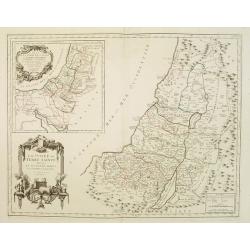
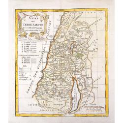
" La Terre Sainte divisée en ses douze Tribus et ses deux Royaumes de Juda et d'Israel.."
A finely engraved and uncommon map depicting Palestine on both sides of the Jordan divided among the twelve tribes and in the two kingdoms of Judah and Israel. Three inse...
Place & Date: Paris 1817
Selling price: $320
Sold
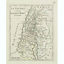
La Giudea o sieno le dodici tribu d'israele
Charming map of the Holy Land from the rare atlas Atlante Tascabile o sia Serie di Num. XXI Cartine Geografiche nelle quali si rappresenta in ristretto lo Stato Attuale d...
Place & Date: Rome, 1823
Selling price: $100
Sold in 2014
Syriae Mappa Generalis .. Paleaestina..
Detailed map of Syria, the Holy Land and the eastern tip of Cyprus. Prepared by Lud.Vivien and engraved in steel by Giraldon-Bovinet. Published by Menard and Desenne, rue...
Place & Date: Paris 1824
Selling price: $70
Sold
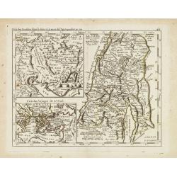
Carte de la Terre Sainte ou des Douze Tribus d'Israel Dressée D'Après les Ouvrages Géographiques De Guil. Delisle. Et d'après les Auteurs et Voyageurs anciens et modernes Par Dezauche, Géographe et successeur de Guil. Delisle et Phil. Buache.
Well-engraved and attractive map of Palestine "divided among the Tribes on both sides of the Jordan and according to the Roman provinces. The shore line runs form Be...
Place & Date: Paris, 1828
Selling price: $200
Sold in 2014
Carte de La Terre Sainte ou des douze tribus d'Israel.
Fine map of Palestine divided among the tribes on both sides of the Jordan and according to the Roman provinces. The shore line runs from Beirut to the rivers of Egypt. W...
Place & Date: Paris, 1828
Selling price: $300
Sold in 2010
Topographisch-historische Charte von Palaestina. . .
First German text edition of this very decorative, large map of Palestine, edited by the German orientalist and theologian Ernst Friedrich Karl Rosenmüller (1768-1835), ...
Place & Date: Leipzig, Baumgärtners Buchhandlung, 1830
Selling price: $350
Sold in 2008
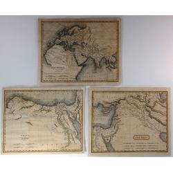
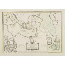
The World as Known to the Ancients, Egypt with Libya & The East (3 Maps)
Three fine Holy Land maps by Sidney Hall. Sidney Hall (1788–1831) was a British engraver and cartographer well known and popular for his early nineteenth century atlase...
Place & Date: London, ca. 1830
Selling price: $20
Sold in 2018
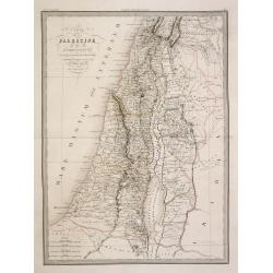
Carte de la Palestine ou Terre Sainte..
Detailed map of Holy Land. Prepared by Alexandre Emile Lapie, a Colonel de l'Etat Major and first geographer to the King. From his Atlas Universal (1829-37). In lower par...
Place & Date: Paris, 1833
Selling price: $100
Sold in 2008
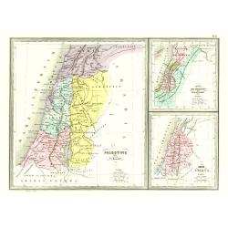
Palestine .. Romains/ .. David et Salomon./ Douze tribes
3 Maps on one sheet of Holy Land during Roman times, during David and Salomon and one divided into 12 tribes.From Malte-Brun's Atlas Géographie Universelle.., revised by...
Place & Date: Paris, 1837
Selling price: $35
Sold
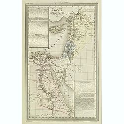
Egypte ancienne et Palestine.
Finely engraved map of Egypt and Palestine with Cyprus, prepared by A.H.Dufour and engraved by Giraldon-Bovinet. Published by Jules Renouard in his uncommon atlas "L...
Place & Date: Paris, Jules Renouard, ca.1840
Selling price: $50
Sold in 2013
Plan de la Ville de Nazareth
A fine map of the city of Nazareth by P. Bellier in Paris in about 1840.Taken from his "GEOGRAPHIC ATLAS & ICONOGRAPHIC FULL COURSE OF SCRIPTURE". There is ...
Place & Date: Paris, ca. 1840
Selling price: $27
Sold in 2016
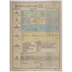
Histoire Sainte, 1840, Cours encyclopédiques - 28e Année - Méthode de Mr Colart . . .
Fine genealogic sheet for educational purpose, about Jewish history. From Adam to Cyrus. In top a map of "Palestine ou Terre Promise en 12 Tribes" 135 x 70mm.
Place & Date: Paris, 1840
Selling price: $240
Sold in 2017
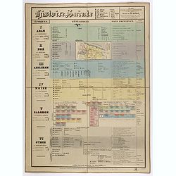
Histoire Sainte, 1840, Cours encyclopédiques - 28e Année - Méthode de Mr Colart . . .
Fine genealogic sheet for educational purpose, about Jewish history. From Adam to Cyrus. In top a map of "Palestine ou Terre Promise en 12 Tribes" 135 x 70mm.
- $350 / ≈ €328
Place & Date: Paris, 1840
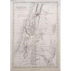
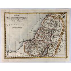
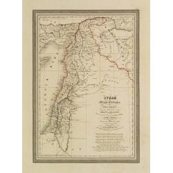
Palestine according to its ancient divisions.
Unusual Adam and Charles Black map of Ancient Palestine, Israel or the Holy Land. It covers the region as it existed in Biblical times with divisions for each of the Twel...
Place & Date: Edinburgh, 1842
Selling price: $36
Sold in 2015
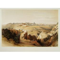
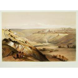
Jerusalem from the road leading to Bethany.
A fine example from David Roberts' monumental works on the Middle East: The Holy Land and Egypt & Nubia, considered the greatest lithographically illustrated works is...
Place & Date: London 1841-1844
Selling price: $500
Sold
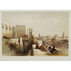
Citadel of Jerusalem.
A fine example from the deluxe issue of David Roberts' monumental works on the Middle East: The Holy Land and Egypt & Nubia, considered the greatest lithographically ...
Place & Date: London, 1841-1844
Selling price: $500
Sold
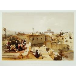
Mosque of Omar showing the site of the Temple.
A fine example of David Roberts' monumental works on the Middle East: The Holy Land and Egypt & Nubia, considered the greatest lithographically illustrated works issu...
Place & Date: London 1841-1844
Selling price: $625
Sold
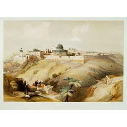
The Church of the Purification.
A fine example from David Roberts' monumental works on the Middle East: The Holy Land and Egypt & Nubia, considered the greatest lithographically illustrated works is...
Place & Date: London 1841-1844
Selling price: $500
Sold
Jerusalem from the mount of Olives.
A fine example from David Roberts' monumental works on the Middle East: The Holy Land and Egypt & Nubia, considered the greatest lithographically illustrated works is...
Place & Date: London 1841-1844
Selling price: $500
Sold
Égypte Palestine et Phénicie.
Detailed map of Egypt, Cyprus and the Holy Land, prepared by Auguste Henri Dufour (1798-1865). Published by Basset, rue de Seine 33, Paris. The engraver of the map was Ch...
Place & Date: Paris 1846
Selling price: $20
Sold
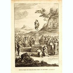
Idolatrie du veau d'or des Israelites dans le desert. Exod. XXXII.1.8.
Print showing the Adoration of the golden calf by the Israelites in the desert. From "Atlas géographique et iconographique du Cours complet d'Écriture sainte... gr...
Place & Date: Paris, M. L. Migne, 1844-1846
Selling price: $15
Sold in 2016
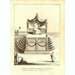
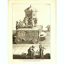
Estrade, ou Tribune d'Airin de Salomon, suivant les dimensions données 2.Paralip. chap6. v13
Print showing a platform with the Throne Airin Solomon. From "Atlas géographique et iconographique du Cours complet d'Écriture sainte... gravé... sous la directio...
Place & Date: Paris, M. L. Migne, 1844-1846
Selling price: $15
Sold in 2015
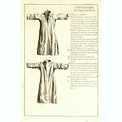
Explication de la figure du métier.
Explanation how to sew garments. From "Atlas géographique et iconographique du Cours complet d'Écriture sainte... gravé... sous la direction de Théophile Blancha...
Place & Date: Paris, M. L. Migne, 1844-1846
Selling price: $15
Sold in 2016

Représenation exacte de la robe de N.S gardée précieusement dans l'églisede Tréves.
Print showing the Holy Tunic venerated in the Cathedral of Trier, worn by Jesus Christ at Calvary. From "Atlas géographique et iconographique du Cours complet d'Éc...
Place & Date: Paris, M. L. Migne, 1844-1846
Selling price: $15
Sold in 2017
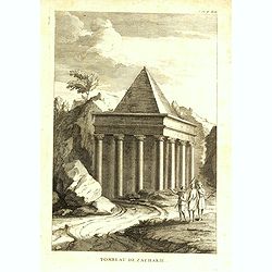
Tombeau de Zacharie.
Print showing the Tomb of Zechariah. The monument is a monolith - it is completely carved out of the solid rock and does not contain a burial chamber. The lowest part of ...
Place & Date: Paris, M. L. Migne, 1844-1846
Selling price: $10
Sold in 2016
Un des dix bassins d'Airain du temps de Salomon qui servaient à laver les victimes, les vases.
Print showing one of the ten wheeled movable basin used in the courtyard of the temple of Solomon. From "Atlas géographique et iconographique du Cours complet d'Éc...
Place & Date: Paris, M. L. Migne, 1844-1846
Selling price: $7
Sold in 2014
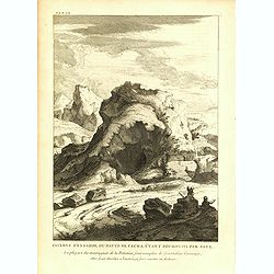
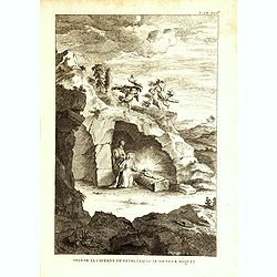
Caverne d'engaddi, où David se cacha, étant poursuivi par Saul.
Print showing the cave of Engedi, where David hide himself when being pursued by Saul. From "Atlas géographique et iconographique du Cours complet d'Écriture saint...
Place & Date: Paris, M. L. Migne, 1844-1846
Selling price: $10
Sold in 2015
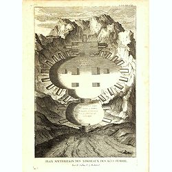
Plan souterrain des tombeaux des rois d'Israël.
Print showing the underground plan of tombs of the Kings of Israel. From "Atlas géographique et iconographique du Cours complet d'Écriture sainte... gravé... sous...
Place & Date: Paris, M. L. Migne, 1844-1846
Selling price: $8
Sold in 2016

Veuë, et élévation du tombeau des rois d'Israël.
Print showing the Tomb of the Kings of Israel. From "Atlas géographique et iconographique du Cours complet d'Écriture sainte... gravé... sous la direction de Thé...
Place & Date: Paris, M. L. Migne, 1844-1846
Selling price: $10
Sold in 2016
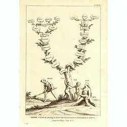
Arbre généalogique des descendants d'Adam et d'Eve, jusqu'au déluge.
Print showing the genealogy tree of the descendants of Adam and Eve. From "Atlas géographique et iconographique du Cours complet d'Écriture sainte... gravé... sou...
Place & Date: Paris, M. L. Migne, 1844-1846
Selling price: $80
Sold in 2016
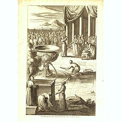
Cérémonies des eaux de Jalousie.
Print showing a water ceremony. From "Atlas géographique et iconographique du Cours complet d'Écriture sainte... gravé... sous la direction de Théophile Blanchar...
Place & Date: Paris, M. L. Migne, 1844-1846
Selling price: $8
Sold in 2016

Lavoir, ou bassin d'Airin qui étoit dans le parvis du Tabernacle.
Print showing a basin. From "Atlas géographique et iconographique du Cours complet d'Écriture sainte... gravé... sous la direction de Théophile Blanchard et Barr...
Place & Date: Paris, M. L. Migne, 1844-1846
Selling price: $10
Sold in 2016
Veuë de la caverne de Betheléem où le sauveur nâquit.
Print showing the view of the cave of Bethelem where Jesus was born . From "Atlas géographique et iconographique du Cours complet d'Écriture sainte... gravé... so...
Place & Date: Paris, M. L. Migne, 1844-1846
Selling price: $10
Sold in 2020
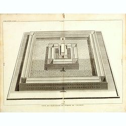
Veuë, et évélation du temple de Salomon.
Print showing a bird's-eye view of Solomon's Temple. From "Atlas géographique et iconographique du Cours complet d'Écriture sainte... gravé... sous la direction d...
Place & Date: Paris, M. L. Migne, 1844-1846
Selling price: $25
Sold in 2015
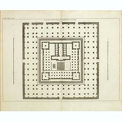
Plan du temple rebati par herodes le grand.
Print showing the plan of the temple rebuilt by the great Herodes. From "Atlas géographique et iconographique du Cours complet d'Écriture sainte... gravé... sous ...
Place & Date: Paris, M. L. Migne, 1844-1846
Selling price: $12
Sold in 2015
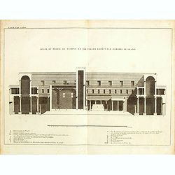
Coupe, et profil du temple de Jérusalem par Hérodes le grand.
Print showing the profile and the Temple of Jerusalem by Herod the Great. From "Atlas géographique et iconographique du Cours complet d'Écriture sainte... gravé.....
Place & Date: Paris, M. L. Migne, 1844-1846
Selling price: $8
Sold in 2015
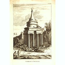
Tombeau d'Absalom.
Print showing Tomb of Absalom, also called Absalom's Pillar, which is an ancient monumental rock-cut tomb with a conical roof located in the Kidron Valley in Jerusalem. F...
Place & Date: Paris, M. L. Migne, 1844-1846
Selling price: $15
Sold in 2016
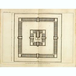
Plan nouveau du temple de Salomon, suivant l'auteur.
Print showing the new plan of Solomon's Temple. From "Atlas géographique et iconographique du Cours complet d'Écriture sainte... gravé... sous la direction de Th�...
Place & Date: Paris, M. L. Migne, 1844-1846
Selling price: $20
Sold in 2016
Palestine.
A large detailed map of the Holy Land, in fact, one of the largest maps of of this region to appear in a mid-19th century. Shows many towns, roads, rivers, mountains, lak...
Place & Date: Edinburgh, 1846
Selling price: $50
Sold in 2021
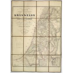
Carte Topographique de la Palestine dressée d'après la carte topographique levée par le savant Jacotin . . .
Uncommon folding map of the Holy Land published by Philip van der Maelen. Prepared by Jean van de Cotte after Jacotin and includes information gardened during expeditions...
Place & Date: Brussels, 1847
Selling price: $310
Sold in 2013
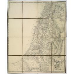
No title, a folding map of Palistine.
A rare proof state of Jacotin's map Carte Topographique de la Palestine. . All text on this issue is not filled in yet. The map has been updated by Jean van de Cotte and ...
Place & Date: Brussels, 1847
Selling price: $325
Sold in 2018