Browse Listings in America > South America > South America
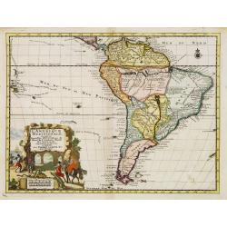
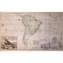
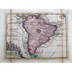
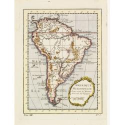
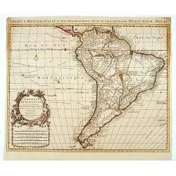
L'Amerique Meridionale. Suivant les nouvelles observations?
Detailed map of South America. Decorative cartouche lower left.Although not renowned for the originality of his work, Pieter van der Aa is highly thought of for the desig...
Place & Date: Amsterdam 1728
Selling price: $75
Sold
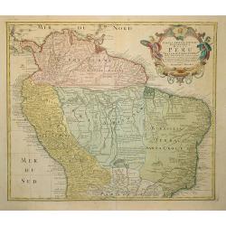
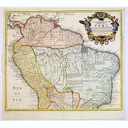
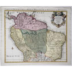
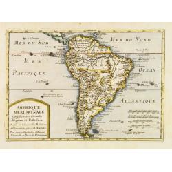
Tabula Americae Specialis Geographica Regni Peru . . .
A good and clean copy of Homann's map of the northern part of South America. Imposing title cartouche.
Place & Date: Nuremberg 1728
Selling price: $275
Sold in 2011
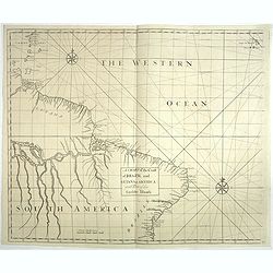
A chart of the coast of Brazil and Guiana in America with part of the Caribbe Islands.
This fine English chart of Brazil, Suriname and a few Caribbean Islands has two large compass roses in the Atlantic Ocean. From "Atlas Maritimus & Commercialis, ...
Place & Date: London, 1728
Selling price: $170
Sold in 2017
![[Lot of 2 maps] Carte de la Terre Ferme, du Perou, du Bresil, et du Pays des Amazones. . . /](/uploads/cache/48132-250x250.jpg)
[Lot of 2 maps] Carte de la Terre Ferme, du Perou, du Bresil, et du Pays des Amazones. . . /
A handsome pair of maps that together make up South America. The first map is of the northern part of South America based on the cartography of Guillaume Delisle.It is fi...
Place & Date: Amsterdam, 1728
Selling price: $200
Sold in 2022
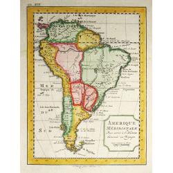
Amerique Meridionale.
A striking map of South America from the “METHODE POUR ETUDIER L’HISTOIRE” by L’Abbe Lenglet du Fresnoy, published in Paris in 1729. The map is quite rare, and is...
Place & Date: Paris, 1729
Selling price: $125
Sold in 2020
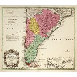
Typus Geographicus Chili Paraguay Freti Magellanici &c ?
An attractive map with much information and engraved notes. With inset map of the Strait of Magellan.
Place & Date: Nuremberg, 1733
Selling price: $280
Sold in 2010
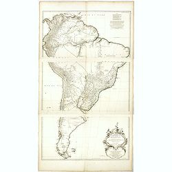
![Tabula Americae Specialis Geographica Regni Peru, Brasiliae, Terra Firmae & Reg: Amazonum, Secundum relationes de Herrera . . . [together with]](/uploads/cache/37397-250x250.jpg)
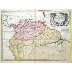
Tabula Americae Specialis Geographica Regni Peru, Brasiliae, Terra Firmae & Reg: Amazonum, Secundum relationes de Herrera . . . [together with]
A good and clean copy of Homann's map of the northern part of South America. The map is on the Valley of the Amazon and delineates the Amazon and its labyrinth of tributa...
Place & Date: Nuremberg, 1733
Selling price: $325
Sold in 2016
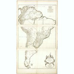
Tabula Americae Specialis Geographica Regni Peru, Brasiliae, Terra Firmae & Reg: Amazonum, Secundum relationes de Herrera. . .
A good and clean copy of the top half of Homann's map of the northern part of South America. The map is on the Valley of the Amazon and delineates the Amazon and its laby...
Place & Date: Nuremberg, 1733
Selling price: $120
Sold in 2017
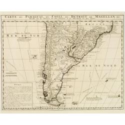
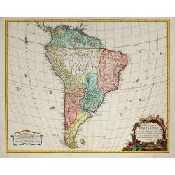
Carte du Paraguai, du Chili, du Detroit de Magellan &c..
Large, finely engraved map of the southern part of South America with great topographical detail and notations throughout.The tracks of several explorations are noted in ...
Place & Date: Amsterdam 1720-1735
Selling price: $300
Sold in 2008
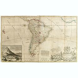
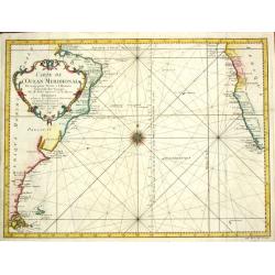
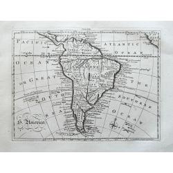
Map of South America, according to the Newest and most exact observations. . .
From 'The World described'. The elaborate cartouche designed by Bernard Lens and engraved by George Vertue is balanced by a large (8 x 10) inset view of Potosi with a not...
Place & Date: London, 1736
Selling price: $1000
Sold in 2015
To the right honourable Charles Earl of Sunderland and Beron Spencer of Wormleighton. . . This map of South America. . .
Map of South America including part of Central America. Cartographic elements include lines of latitude and longitude, compass rose, indication of wind directions, locati...
Place & Date: London, 1726-1736
Selling price: $600
Sold in 2015
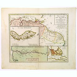
Kaart...Guajana of de Wilden Kust...Westindien...
Tirion's excellent map of the northern coast of Venezuela, Columbia and parts of northern Guyana.Lovely small inset map of the Dutch colony of Curacao, together with a fu...
Place & Date: Amsterdam, 1740
Selling price: $150
Sold in 2016
Tabula geographica Peruae Brasiliae & Amazonum Regionis.
Covens & Mortier's large size detailed map of the northern part of South America, after Guillaume De L'Isle, 1721-1742.Full title on the map: 'Tabula geographica Peru...
Place & Date: Amsterdam, 1721-1742
Selling price: $250
Sold in 2020
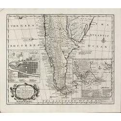
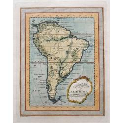
A New and Accurate Map of Chili, Terra Magellanica, Terra del Fuego &c
Bowen's map of the southern part of South America from 'A Complete System of Geography'. With one title cartouche and a compass rose. With two inset maps, one of Santiago...
Place & Date: London, 1747
Selling price: $375
Sold in 2010
Zuyd America. L'Amerique Meridionale.
An unusual map of South America in an early shape and with two mythological lakes. The track of Jacques Le Maire is shown in the Pacific. Above the title cartouche, nativ...
Place & Date: Amsterdam, 1747
Selling price: $21
Sold in 2018
Amérique Meridionale..
Uncommon map of South America in 3 sheets.
Place & Date: Paris, 1748
Selling price: $400
Sold in 2016
Amérique Meridionale. . .
Uncommon wall map of South America published by d''Anville and engraved by the master Guilluime Delahaye. Prepared by de la Condamine.
Place & Date: Paris, 1748
Selling price: $500
Sold in 2018
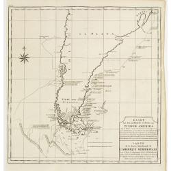
Kaart van het Zuidelykste Gedeelte van Zuider Amerika.. - Carte de la Partie Meridionale de l'Amerique Meridionale..
This fine chart shows the route of Capt. George Anson's ship "The Centurion" down the east coast of South America from St. Catherine's Island off the coast of B...
Place & Date: Amsterdam, ca 1749
Selling price: $120
Sold in 2012
Amerique meridionale pour servir à l'Histore Generale des Voyages.
Bellin's distinctive map of the continent, from Prevost d'Exiles' influential travel book, Histoire Générale des Voyages, features a charming decorative cartouche.
Place & Date: Paris 1750
Selling price: $50
Sold
Amèrique Méridionale divisée en ses Grandes Régions et Possessions.
Uncommon map of South America after J.B.Nolin for Introduction à l'Histoire Universelle du Baron de Puffendorf.
Place & Date: Paris c.1750
Selling price: $90
Sold
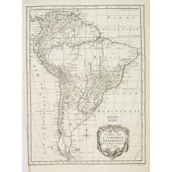
Amérique Méridionale, dressée, sur les Mémoires les plus récents . . .
South America, dated 1750, providing a clear summary of European knowledge at the time. From the Atlas Universel.
Place & Date: Paris, 1750
Selling price: $275
Sold in 2010
![[9 maps of Peru and Chili]](/uploads/cache/20641-(1)-250x250.jpg)
[9 maps of Peru and Chili]
A map of the Southamerican continent from the Dutch edition of Robertson's ' History of America'.Plus 8 maps of Peru and Chili
Place & Date: London, ca. 1750
Selling price: $200
Sold in 2022
![[lot of 5 maps/prints map of South America] Chili. Paraguay, Brésil, Amazones, et Pérou.](/uploads/cache/19976-(2)-250x250.jpg)
[lot of 5 maps/prints map of South America] Chili. Paraguay, Brésil, Amazones, et Pérou.
Louis Brion de la Tour (1756-1823), ' Atlas Géneral, Civil et Ecclésiastique', 1766, ' Atlas Général', 1790-98. Louis Charles Desnos (fl.1750-70), Paris-based publish...
Place & Date: Paris, c. 1750
Selling price: $200
Sold in 2022
Neue und richtige Karte von dem Stillen Meere oder Mar der Sur . . . Pl.XXXVI.
Coastline map of Mexico starting from Acapulco and also including the Bay de San Francisco, the image oriented with East at the top of the image, which is largely of the ...
Place & Date: Leipzig, 1753
Selling price: $80
Sold in 2015
Neue und richtige Karte von dem Stillen Meere oder Mar der Sur . . . Pl.XXXVI.
Coastline map of Mexico starting from Acapulco and also including the Bay de San Francisco, the image oriented with East at the top of the image, which is largely of the ...
Place & Date: Leipzig, 1753
Selling price: $55
Sold in 2008
Neue und richtige Karte von dem Stillen Meere oder Mar der Sur . . . Pl.XXXVI.
Coastline map of Mexico starting from Acapulco and also including the Bay de San Francisco, the image oriented with East at the top of the image, which is largely of the ...
Place & Date: Leipzig, 1753
Selling price: $80
Sold in 2012
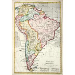
L'Amerique Meridionale Dressée sur les Observations
Detailed map of South America prepared by De L'Isle, with fine title cartouche.
Place & Date: Amsterdam 1757
Selling price: $320
Sold
Carte de l''Amérique Méridionale..
A good engraved map of South America with rococo title cartouche lower right. From l'Histoire générale des voyages .
Place & Date: Paris, 1758
Selling price: $60
Sold in 2015
Carte de l' Ocean Meridional, 1746.
Jaques Nicolas Bellin (1702-720) was the most important French hydrographer of the 18th century. Sea-atlas 'Hydrographique Français' , 1756-65, atlas to accompany Prévo...
Place & Date: Amsterdam, c. 1760
Selling price: $175
Sold
Amerique Meridionale.
Jaques Nicolas Bellin (1702-720) was the most important French hydrographer of the 18th century. Sea-atlas 'Hydrographique Français' , 1756-65, atlas to accompany Prévo...
Place & Date: Paris, c. 1760
Selling price: $85
Sold in 2008
An Accurate Map of South America Drawn from the Sieur Robert.
Detailed map of South America by George Rollos. From Vaugondy's map. Decorated with a fancy Rococo cartouche.
Place & Date: Paris, c1760
Selling price: $22
Sold in 2013
Carta rappresentante l'America Meridionale.
Rare map of South America, published in 1763 (Gazettiere Americano?). Indicates major cities, rivers, and mountains. With a frame style border, nice hand coloring, and a ...
Place & Date: Livorno, 1763
Selling price: $94
Sold in 2015
South America.
Uncommon miniature map of South America, engraved by Thomas Kitching for "A New General and Universal Atlas Containing Forty five Maps by Andrew Dury".This mini...
Place & Date: London, 1761-1763
Selling price: $35
Sold in 2018
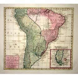
Kaart van het Onderkoningschap van Peru, zig uitstrekkende over Chili, Paraguay en andere Spaansche Landen: als ook van Brazil en verdere Bezitting en van Portugal in Zuid - Amerika.
Nice detailed map of most of the continent - leaving off the northern coastline. The southern tip is enclosed in a large inset balancing the composition with the block-st...
Place & Date: Amsterdam, 1765
Selling price: $190
Sold
Amérique Méridionale.
Rigobert Bonne (1727-1795), French cartographer. His maps are found in a.o. Atlas Moderne (1762), Raynal's Histoire Philos. du Commerce des Indes (1774) and Atlas Encyclo...
Place & Date: Paris, c. 1770
Selling price: $60
Sold

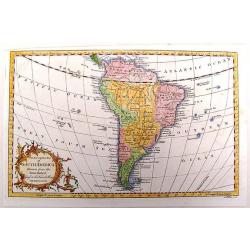
America Meridionalis Concinnata juxta Observationes Dnn Acad
colored copper engraving showing South America. After a map of De l'Isle.
Place & Date: Augsburg, 1770
Selling price: $280
Sold in 2009
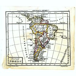
S. America.
Uncommon map of South America. With many details and place names. With small specks of land "Terra Australis", "Port discover'd by Sir Francis Drake",...
Place & Date: London, ca. 1770
Selling price: $20
Sold in 2014
Carte De La Terre Ferme, de la Guyane, et du Pays des Amazones...
Fine map of the northern part of South America, including Aruba, Bonaire, Curacao, Trinidad, Columbia, Peru, Venezuela, Ecuador, Guyana, and the northern part of Brazil. ...
Place & Date: Paris, 1771
Selling price: $75
Sold in 2018
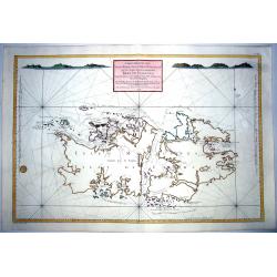
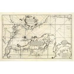
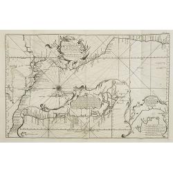
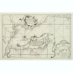
CARTE REDUITE DES ISLES MALOUINES OU .. ISLES DE FALKLAND 1771
Large-scale nautical chart of the Falkland islands with rhumb lines, soundings and anchorages, detailed chart with depth soundings and the tracks of recent French and Eng...
Place & Date: Paris, 1771
Selling price: $250
Sold in 2021
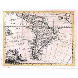
South America
"South America" by Thomas Jefferys, published in “A New Geographical and Historical Grammar” in London in 1772.Thomas Jefferys (c.1719–1771), "Geogra...
Place & Date: London, 1772
Selling price: $50
Sold in 2017