Browse Listings in America > South America > Magallan / Tierra del Fuego
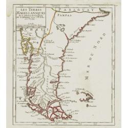
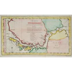
Les Terres Magéllaniques.
Nice small map of the southernmost tip of South America. The Falkland Islands have only partial coastlines.From Atlas Portatif Universel, by Robert de Vaugondy. 111 outsi...
Place & Date: Paris, later than 1749
Selling price: $160
Sold in 2009
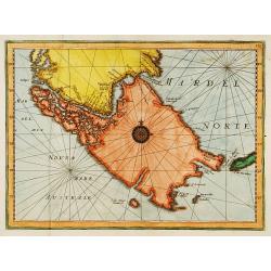
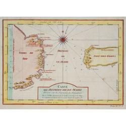
Tierra del Fuogo.
An attractive map centred on the extreme part of South America, including the Horn Cape.
Place & Date: Venice 1750
Selling price: $200
Sold
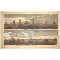
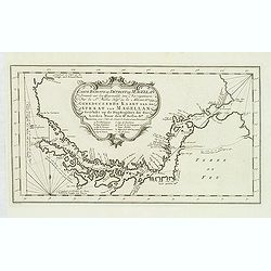
Cap de la Vierge Marie a L'Entre du Detroit de Magellan & Vue d'Une Partie de la Cote du N.E. de la Terre de Fue a L'Entree du Detroit de la Maire
Hand colored views of two costal areas of Magellan Straight off the coast of Terre del Fuega. Each view has seven two and three masted ship. George Anson, 1st Baron Anso...
Place & Date: Paris, 1750
Selling price: $110
Sold in 2013
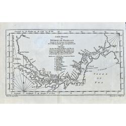
![[Lot of 7 maps / views of Patagonia, Strait Magellan] Carte réduite du Détroit de Magellan](/uploads/cache/100098-(3)-250x250.jpg)
[Lot of 7 maps / views of Patagonia, Strait Magellan] Carte réduite du Détroit de Magellan
A chart of the Strait of Magellan from a Dutch edition of Prevost.s ' Voyages".Jacques Nicolas Bellin (1702-720) was the most important French hydrographer of the 18...
Place & Date: Paris, c. 1750
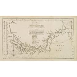
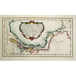
Carte reduite du Détroit de Magellan..
A good engraved map of Strait of Magellan. The geographical features are typical with somewhat exaggerated bays and inlets. From l'Histoire générale des voyages .
Place & Date: Paris 1753
Selling price: $45
Sold
Carte reduite du Détroit de Magellan . . .
A good engraved map of Strait of Magellan. The geographical features are typical with somewhat exaggerated bays and inlets. From l'Histoire générale des voyages.
Place & Date: Paris, 1753
Selling price: $35
Sold in 2010
Carte du Détroit de Le Maire . . .
A good engraved map of Strait of Le Maire. From Histoire générale des voyages.
Place & Date: Paris, 1753
Selling price: $40
Sold in 2011
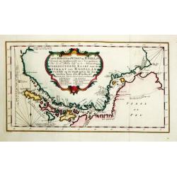
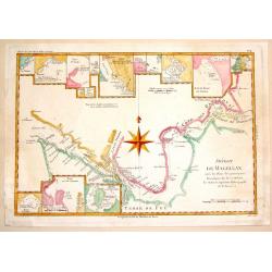
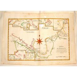
Carte Reduite du Detroit de Magellan. . .
Detailed chart of the Strait of Magellan from Cap des Vierges to Cap de la Victoire. The rococo title cartouche with title in French and Dutch "Gereduceerde Kaart va...
Place & Date: Amsterdam, 1753
Selling price: $65
Sold in 2012
Carte réduite du Détroit de Magellan
Jaques Nicolas Bellin (1702-720) was the most important French hydrographer of the 18th century. Sea-atlas 'Hydrographique Français' , 1756-65, atlas to accompany Prévo...
Place & Date: Amsterdam, c. 1760
Selling price: $150
Sold
Carte réduite du Détroit de Magellan.
Jaques Nicolas Bellin (1702-720) was the most important French hydrographer of the 18th century. Sea-atlas 'Hydrographique Français' , 1756-65, atlas to accompany Prévo...
Place & Date: Paris, c. 1760
Selling price: $80
Sold
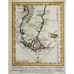
Carte Réduite de la Partie la plus Meridionale de l'Amerique.
Jaques Nicolas Bellin (1702-720) was the most important French hydrographer of the 18th century. Sea-atlas 'Hydrographique Français' , 1756-65, atlas to accompany Prévo...
Place & Date: Amsterdam, c. 1760
Selling price: $130
Sold
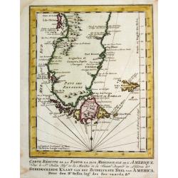
Carte Réduite de la Partie la plus Meridionale de l'Amerique.
Jaques Nicolas Bellin (1702-720) was the most important French hydrographer of the 18th century. Sea-atlas 'Hydrographique Français' , 1756-65, atlas to accompany Prévo...
Place & Date: Amsterdam, c. 1760
Selling price: $65
Sold in 2008
Carte réduite du Détroit de Magellan
Jaques Nicolas Bellin (1702-720) was the most important French hydrographer of the 18th century. Sea-atlas ''Hydrographique Français'' , 1756-65, atlas to accompany Pré...
Place & Date: Amsterdam, c. 1760
Selling price: $125
Sold in 2008
Carte Reduite Du Détroit de Magellan. . .
Bellin's important and interesting map of the Straits of Magellan and parts of Tierra del Fuego, dated 1753. It extends from Cap des Vierges to Cap de la Victoire, and in...
Place & Date: Paris, ca. 1760
Selling price: $50
Sold in 2021
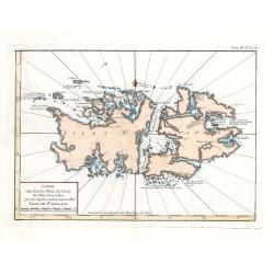
Carte Des Isles Malouines ou Isles Nouvelles - Isles de Falkland
This elegant sea chart of the Falkland Islands by Jacques Nicolas Bellin is from his ‘Le Petit Atlas Maritime…’, which covered the world to the extent it was known ...
Place & Date: Paris, 1764
Selling price: $75
Sold in 2023
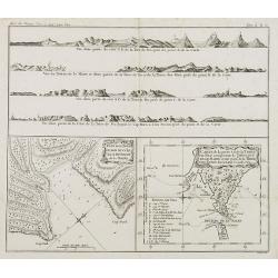
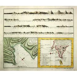
Plan de la Baye du Bon succès dans le détroit de le Maire. / Carte de la partie S. E. de la Terre de Feu. . . / 4 profils figurant la Terre de feu. Tome II Pl. 6.
Charts of the Detroit of Le Maire and of Tierra del Fuego in Spanish for "Land of Fire" situated on the southernmost tip of the South American mainland by the S...
Place & Date: Paris, 1769
Selling price: $70
Sold in 2008
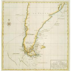
Carte de la Partie Meridionale de l\'Amerique Meridionale.
A coastal chart of southern South America showing the route of the Centurion from the Island of St. Catherine (Brazil) to the Island of Juan Fernandez (in the Pacific).
Place & Date: Paris c.1770
Selling price: $120
Sold
Extrémité Méridionale de l'Amerique.
Rigobert Bonne (1727-1795), French cartographer. His maps are found in a.o. Atlas Moderne (1762), Raynal's Histoire Philos. du Commerce des Indes (1774) and Atlas Encyclo...
Place & Date: Paris, c.1770
Selling price: $115
Sold in 2008
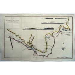
Détroit de Magellan, avec les Plans des principaux ports, Bayes etc. de ce Détroit.
Rigobert Bonne (1727-1795), French cartographer. His maps are found in a.o. Atlas Moderne (1762), Raynal's Histoire Philos. du Commerce des Indes (1774) and Atlas Encyclo...
Place & Date: Paris, c.1770
Selling price: $130
Sold
Carte Reduite Du Détroit de Magellan...
Bellin's important and interesting map of the Straits of Magellan and parts of Tierra del Fuego. Extends from Cap des Vierges to Cap de la Victoire. Indicating many bays,...
Place & Date: Paris, ca. 1770
Selling price: $50
Sold in 2017
Carte réduite du Détroit de Magellan. . .
Uncommon edition of this fine map southern part of South America with Straits Magellan. In lower right engraved "27."From Atlas Portatif pour servir a l'intelli...
Place & Date: Amsterdam, 1773
Selling price: $130
Sold in 2011
![Vue des Indiens de la Terre de Feu dans leurs huttes. [Tome II Pl. 7.]](/uploads/cache/26105-250x250.jpg)
Vue des Indiens de la Terre de Feu dans leurs huttes. [Tome II Pl. 7.]
Family scene in a Patagonian hut. From the French edition of James Cook's first voyage entitled Relation des voyages entrepris par ordre de sa Majesté Britannique actuel...
Place & Date: Paris, 1773
Selling price: $40
Sold in 2012
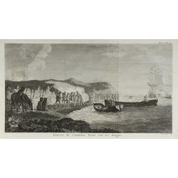
![Entrevue du Commodore Byrou avec les Patagons. [Tome I Pl. 6.]](/uploads/cache/26104-250x250.jpg)
Entrevue du Commodore Byrou avec les Patagons. [Tome I Pl. 6.]
Commodore Byron in talks with the native tribes of Patagonia. From the French edition of James Cook's first voyage entitled Relation des voyages entrepris par ordre de sa...
Place & Date: Paris, 1774
Selling price: $50
Sold in 2013
Entrevue du Commodore Byron avec les Patagons.
From the French edition of James Cook's first voyage entitled Relation des voyages entrepris par ordre de sa Majesté Britannique actuellement régnante pour faire des d�...
Place & Date: Paris, 1774
Selling price: $40
Sold in 2010
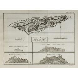
Carte et Vues de l'Isle Pitcairn.
From the French edition of James Cook's first voyage entitled Relation des voyages entrepris par ordre de sa Majesté Britannique actuellement régnante pour faire des d�...
Place & Date: Paris, 1774
Selling price: $30
Sold in 2010
Magellan Strait, Carte du Detroit de Magellan .. Les Observations .. Decouvertes du Capt. Byron - Wallis - Carteret
Rare chart of the Straits of Magellan from the Relation des Voyages Entrepris par Ordre de sa Majeste Britannique, the French edition of the official account of the fir...
Place & Date: Paris, 1774
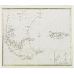
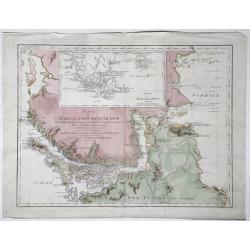
Kaart van het Zuidlyk Eind van Amerika. 1775.
Uncommon chart of the tip of South America, showing Patagonia, Tierra del Fuego and the Falkland Islands. With an inset of Staaten Land in the lower right corner.Publishe...
Place & Date: Amsterdam c. 1780
Selling price: $220
Sold
Extrémité Meridionale De Amérique.
Map shows Tierra del Fuego, with 5 inset maps of Canal de Noel, Terre de Feu, Bay Dubon, and the coast.Rigobert Bonne (1727–1795) was one of the most important cartogra...
Place & Date: Paris, ca. 1780
Selling price: $55
Sold in 2018
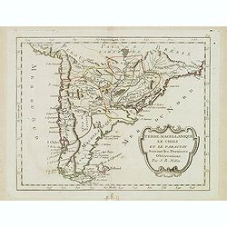
Terre Magellanique le Chili et le Paraguay. . .
Scarce map of southern most South America, prepared by Nolin and published by L.J. Mondhare for his Atlas Général a l'usage des colleges et maisons d'education.. Louis ...
Place & Date: Paris, 1781
Selling price: $175
Sold in 2014
Carte du Chili Méridional, du Rio de la Plata, des Patagons, et du Détroit de Magellan. . .
Finely and crisply engraved map representing the southern tip of South America. It extends northwards as far as the river de la Plata estuary.Venetian edition of d'Anvill...
Place & Date: Venice, 1776 - 1784
Selling price: $450
Sold in 2012
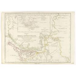
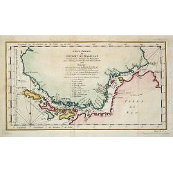
Karte der Magellanischen-Strasse. . .
Very detailed map of Strait of Magellan, with in top inset map of Southern tip of South America with the Falklands. Incorporating the discoveries of Herrn, Byron, Wallis,...
Place & Date: Vienna, 1787
Selling price: $300
Sold in 2017
Detroit de Magellan.
A detailed engraved chart of the Straits of Magellan (between South America and Terra del Fuego), showing the best route through the dangerous straits. With 16 separate i...
Place & Date: Paris, 1787
Selling price: $71
Sold in 2014
Karte der Magellanischen Strasse.
Full title at center of the map: 'Karte der Magellanischen Strasse von Herrn Don Juan de la Cruz Canoy Olmedillo. Und nach den Beobachtungen der Herrn Byron, Wallis, Cart...
Place & Date: Wien, 1787
Selling price: $250
Sold in 2021
Detroit de Magellan avec les Plans des Pricipaux, Ports, Baves & de ce Detroit.
Interesting hand-colored, copperplate map of The Straits of Magellanshowing the direction of the currents, bays, points, soundings, harbours, islands, shoals etc. Large c...
Place & Date: Paris, 1788
Selling price: $17
Sold in 2015
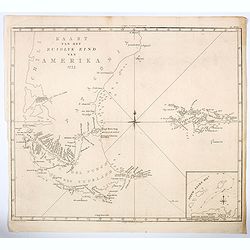
Kaart van het Zuidlyk Eind van Amerika. 1775.
An uncommon Dutch chart of the tip of South America, showing Patagonia, Tierra del Fuego and the Falkland Islands. With an inset of Staaten Land in the lower right corner...
Place & Date: Amsterdam ca 1790
Selling price: $175
Sold in 2020
![[Lot of 11 maps of the Strait of Magellan] Carte du detroit de Magellan avec les Routes de la Bodeuse et de l'Etoile.](/uploads/cache/19991-(3)-250x250.jpg)
[Lot of 11 maps of the Strait of Magellan] Carte du detroit de Magellan avec les Routes de la Bodeuse et de l'Etoile.
Carte du Detroit de Magellan avec les Routes de la Bodeuse et de l'Etoile taken by the French discoverer Comte de Bougainvile, L.A. With in addition 10 maps / prints of...
Place & Date: Paris, c. 1790
Selling price: $258
Sold in 2022
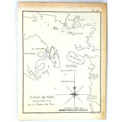
Canal de Noël sur la côte S.O. de la Terre de Feu.
A simple map of Christmas Sound from James Cook’s voyages. Cook reached Christmas Sound near Tierra del Fuego on 25th & 26th December 1774, returning to England on ...
Place & Date: London, 1794
Selling price: $24
Sold in 2016
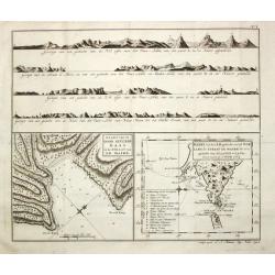
Carte de la Baye du Bon Succès dans le Détroit de le Maire./ Carte de la partie S.E. de la Terre de Feu comprenant le Détroit de le Maire et une part.ie de la Terre des Etats. 1769.
Captain James Cook (1728-79), explorer, circumnavigator and hydrographer. Three voyages, 1768-71, 1772-75 and 1776-79. From 1778 on printed editions of ' Captain Cook's T...
Place & Date: Paris, c. 1795
Selling price: $210
Sold
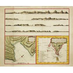
Carte de la Baye du Bon Succès dans le Détroit de le Maire./ Carte de la partie S.E. de la Terre de Feu comprenant le Détroit de le Maire et une part.ie de la Terre des Etats. 1769.
Captain James Cook (1728-79), explorer, circumnavigator and hydrographer. Three voyages, 1768-71, 1772-75 and 1776-79. From 1778 on printed editions of ' Captain Cook's T...
Place & Date: Paris, c. 1795
Selling price: $150
Sold in 2010
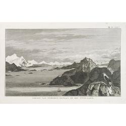
GEZIGT VAN KERSMIS-KANAAL OP HET VUUR-LAND . Pl. LXX*.
A landscape and sea coast view of mountains and a ship in the Strait of Magellan. From a Dutch edition of James Cook.
Place & Date: Amsterdam, ca. 1800
Selling price: $45
Sold in 2010
Kaart van de Good Success Baai in de Straat van le Maire. / Kaart van het Z.O.gedeelte van het Vuurland de Straat Le Maire en een gedeelte van Staaten-Land 1769.
Captain James Cook (1728-79), explorer, circumnavigator and hydrographer. Three voyages, 1768-71, 1772-75 and 1776-79. From 1778 on printed editions of ' Captain Cook's T...
Place & Date: Leiden, 1795-1803
Selling price: $95
Sold in 2018
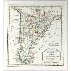
Paraguay, Chili, Terre Magellan. . .
An antique copper engraved map, published 1795, in Paris for the "Nouvel Atlas Portatif..." by Robert de Vaugondy & Charles Francois Delamarche.
Place & Date: Paris, ca. 1811
Selling price: $80
Sold in 2016
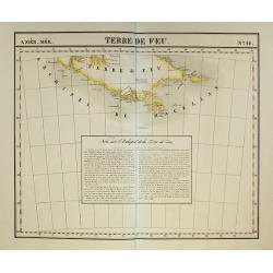
Terre de Feu. No.42.
PLANO sheet map covering Tierra del Fuego, including Cape Horn and Strait Le Maire, etc. With a text block dealing with the area. From his famous Atlas Universel. This at...
Place & Date: Brussels, 1825-1827
Selling price: $60
Sold in 2009
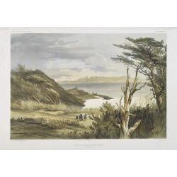
Vue des environs de Port Famine (Detroit de Magellan)
Exquisite contemporary colored lithograph of Port Famine in most southern part of South America, with Dumont D'Urville's officers hunting. Drawn by Ernest Goupil (died 18...
Place & Date: Paris, 1846
Selling price: $310
Sold in 2010
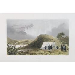
Observatoire de Port Famine. (Detroit de Magellan)
Exquisite contemporary colored lithograph of the Port Famine, situated in the southern tip of America, with Dumont D'Urville's officers discussing in front of a tenth. Dr...
Place & Date: Paris, 1848
Selling price: $250
Sold in 2017
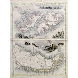
Falkland Islands and Patagonia.
Two very decorative steel-engraved maps on one sheet. Both maps are very detailed with place names, rivers, hills, islands, bays, etc.Attractively illustrated with vignet...
Place & Date: London, ca.1850
Selling price: $40
Sold in 2017
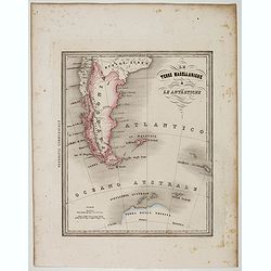
Le Terre Magellanighe e Le Antartiche.
Uncommon map of Patagonia and part of Antarctica, prepared by Francesco Costantino Marmocchi. Above the map "Geografia Commerciale". From "Il Globo Atlante...
Place & Date: Genova, Paolo Rivara fu Giacomo, 1858
Selling price: $15
Sold in 2022
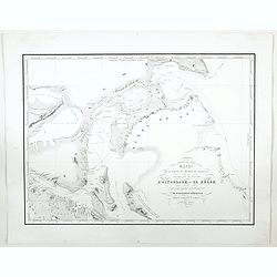
Carte de la partie du Detroit de Magellan reconnue par les Corvettes L'Astrolabe et La Zelee. . .
A detailed map of the Straits of Magellan, prepared by Vincendon Dumoulin after a visit of the ships L'Astrolabe and La Zelee in the year 1841. From Voyage au Pole Sud et...
Place & Date: Paris, 1860
Selling price: $200
Sold in 2023
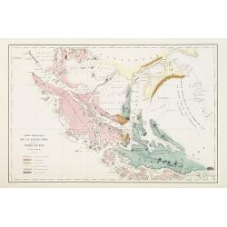
Carte .. De la Patagonie et de la Terre de Feu..
Very detailed map of Strait of Magellan, prepared by J.Grange.Engraved by Jacobs. With a color key to soil conditions.
Place & Date: Paris c.1880
Selling price: $100
Sold
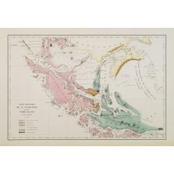
Carte géologique de la Patagonie et de la Terre de Feu.
Very detailed geological map of Strait of Magellan, prepared by J.Grange.Engraved by Jacobs. With a color key to soil conditions.From "Voyage au Pôle Sud et dans l'...
Place & Date: Paris c.1880
Selling price: $400
Sold in 2010
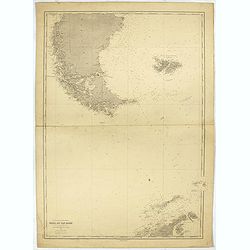
Ocean glacial Antartique - Mers du Cap Horn . . .
Large chart representing the Cap Horn sea, part of Patagonia, Falkland Islands and Palmer Archipelago. A couple of places are highlighted in red.
Place & Date: Paris, 1916 updated to 1934
Selling price: $45
Sold in 2022

The Times Map Of The Trans-Antarctic Expedition Antarctica South Pole Vivian Fuchs Edmund Hillary.
Original vintage advertising poster - The Times Map of the Trans-Antarctic Expedition 1957-1958 Feature articles by Dr Vivian Fuchs and Sir Edmund Hillary on the Trans-An...
Place & Date: England, 1960
Selling price: $1800
Sold in 2023