Browse Listings in America > South America > Chile
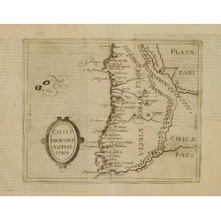
Chili Provincia Amplissima.
Very rare sixteenth century map of Chili.Published in the German edition of José de Acosta's De Natura Nova Orbis, first published in Salamanca, 1588. Acosta was a Spani...
Place & Date: Cologne 1598
Selling price: $300
Sold
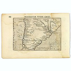
Chili et Patagonum regio.
A rare miniature map of southern part of South America, including Chili, parts of Brazil, and Argentina. Title cartouche on the lower right corner. First published in 159...
Place & Date: Amsterdam, 1606
Selling price: $80
Sold in 2019
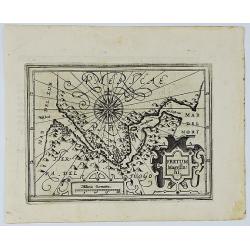
Fretum Magellani.
An early map of Strait Magellan. Depicts the extremity of South America, with Patagonia, the Straight of Magellan, Terra del Fuego and the discoveries made by LeMaire and...
Place & Date: Amsterdam, 1609
Selling price: $180
Sold in 2020
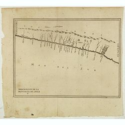
Descripcion De la Provincia de Chile. 13
Rare early map of the province of Chile, locating rivers and settlements, the earliest map to include information from the previously secret manuscript maps of the Spanis...
Place & Date: Amsterdam, Michel Colin, 1622
Selling price: $375
Sold in 2017
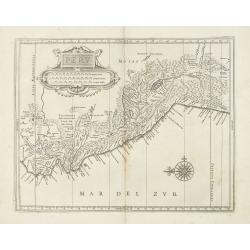
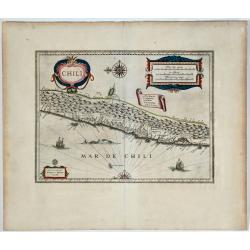
Peru.
Fine map showing mainly the coastline of Peru with large title and scale cartouche in the blank interior. North is to the left.. In the lower right of the map a large com...
Place & Date: Leiden, Elzevier, 1625
Selling price: $275
Sold in 2013
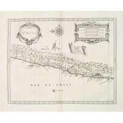
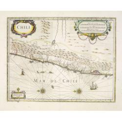
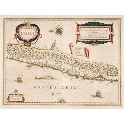
Chili.
Fine map showing mainly the coastline of Chile with large title, scale and key cartouche in the blank interior. North is to the left.. In the upper center of the map a la...
Place & Date: Leiden, Elzevier, 1625
Selling price: $255
Sold in 2013
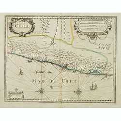
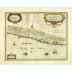
Chili.
Decorative map of Chile from Copiapo to Isla de Chiloé. With the mountains of the Andes, with the main river valleys, provinces and volcanoes of southern Chili, with two...
Place & Date: Amsterdam, after 1630
Selling price: $500
Sold in 2012
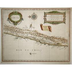
Chili
This beautiful map covers Chili, from Puente de Vetes in the North to Cap de Diego Gallego in the south. North is to the left of the map. Beautiful title cartouche, scale...
Place & Date: Amsterdam, 1630
Selling price: $325
Sold in 2009
![[L'Hermite reaches the Juan Fernandez Islands].](/uploads/cache/41112-250x250.jpg)
[L'Hermite reaches the Juan Fernandez Islands].
After rounding the Horn, the Dutch fleet sailed north-east and, on 5th April 1624, landed on the more easterly island of the Juan Fernandez Islands. On the north-east of ...
Place & Date: Frankfurt, M.Merian, 1633
Selling price: $80
Sold in 2018
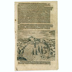
Val Parysa.
Scarce print with a German text sheet. In the June of 1615, the Dutch fleet reached the town of Valparaíso. The natives were dressed as shown (I). The fleet (D) anchored...
Place & Date: Frankfurt, M.Merian, 1633
Selling price: $70
Sold in 2017
Chili.
Willem Blaeu's very decorative map of Chili with two large and beautiful cartouches, a compass and ships. The modern cities of Santiago (identified on the map as "S ...
Place & Date: Amsterdam, 1638
Selling price: $400
Sold in 2010
Chili.
Very decorative map of Chili with two large and beautiful cartouches, a compass and ships. Rare without text on verso. From a French composite atlas. Read more about Dutc...
Place & Date: Amsterdam, Paris, ca. 1639
Selling price: $105
Sold in 2018
Chili.
Willem Blaeu's very decorative map of Chili with two large and beautiful cartouches, a compass and ships.
Place & Date: Amsterdam 1640
Selling price: $300
Sold
Chili.
Very decorative map of Chili with two large and beautiful cartouches, a compass and ships.
Place & Date: Amsterdam, 1639-1644
Selling price: $350
Sold in 2014
Chili.
Very decorative map of Chilli with two large and beautiful cartouches, a compass and ships.
Place & Date: Amsterdam 1646
Selling price: $520
Sold
Chili. 

Willem Blaeu's very decorative map of Chile with two large and beautiful cartouches, a compass and ships.
Place & Date: Amsterdam, 1646
Selling price: $85
Sold in 2019
Chili.
Willem Blaeu's very decorative map of Chile with two large and beautiful cartouches, a compass and ships.
Place & Date: Amsterdam 1646
Selling price: $520
Sold
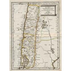
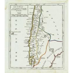
Le Chili ...
Map of Chile, from the first edition of the atlas L'Amérique en plusieurs cartes, et en divers traittés de Géographie, et d'Histoire.Nicolas Sanson was to bring about ...
Place & Date: Paris, 1657
Selling price: $220
Sold in 2012
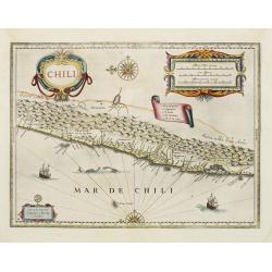
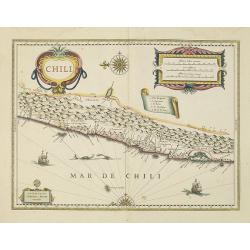
Chili.
Willem Blaeu's very decorative map of Chili with two large and beautiful cartouches, a compass and ships. The modern cities of Santiago (identified on the map as "S ...
Place & Date: Amsterdam, 1658
Selling price: $600
Sold in 2012
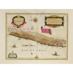
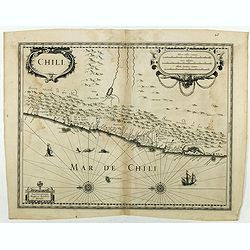
Chili.
Willem Blaeu's very decorative map of Chili with two large and beautiful cartouches, a compass and ships.First edition of the last part of the Latin "Atlas maior&quo...
Place & Date: Amsterdam, 1662
Selling price: $530
Sold in 2010
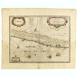
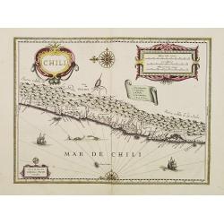
Chili.
Johannes Janssonius' very decorative map of Chili with two large and beautiful cartouches, a compass and ships. The modern cities of Santiago (identified on the map as &q...
Place & Date: Amsterdam, 1666
Selling price: $200
Sold in 2015
Chili.
Johannes Janssonius' very decorative map of Chili with two large and beautiful cartouches, a compass and ships. The modern cities of Santiago (identified on the map as &q...
Place & Date: Amsterdam, 1666
Selling price: $450
Sold in 2012
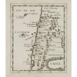
Chili.
Uncommon miniature map of Chile from Pierre Duval's La Geographie Universeille dated 1676. Following his Cartes de geographie in 1657, Pierre Duval published this smaller...
Place & Date: Paris, 1676
Selling price: $50
Sold in 2008
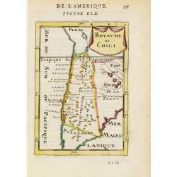
Royaume de Chili.
Interesting early map of Chile. The name Patagons is present on the southern border. The mountain range of the Andes is shown pictorially.From the French text edition of ...
Place & Date: Paris 1683
Selling price: $50
Sold
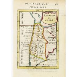
Royaume de Chili.
Interesting early map of Chile. The name Patagons is present on the southern border. The mountain range of the Andes is shown pictorially.From the French text edition of ...
Place & Date: Paris, 1683
Selling price: $40
Sold in 2009
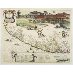
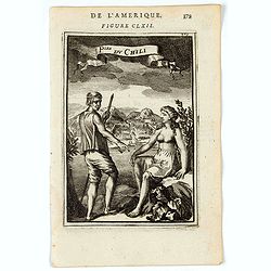
P.les du Chile.
A charming copper engraving depicting a town surrounded by a luxuriant landscape on the background and a couple of indigenous on the foreground.From the French text editi...
Place & Date: Paris, 1683
Selling price: $40
Sold in 2011
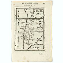
Royaume de Chili.
A charming miniature map of Chili. Title in curtain draped at top. French text on verso.From the original 1683 text edition of "Description d'Univers. . ." by A...
Place & Date: Paris, 1683
Selling price: $50
Sold in 2020
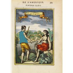
Ples. Du Chili
A charming print of a couple from Chili. Title in curtain draped at top. French text on verso.From the original 1683 text edition of "Description d'Univers. . ."...
Place & Date: Paris, 1683
Selling price: $30
Sold in 2020
Destroit de Magellan, Terre et Isles Magellanicques, etc.
Nicolas Sanson (1600-67), ' father of the French cartography' and founder of the Sanson firm. Atlas ' Cartes générales de toutes les parties du Monde', 1658-70 and a po...
Place & Date: Utrecht, S.de Vries / J. Ribius, 1683
Selling price: $200
Sold
(Globe gore) Della citta di Chiloe. . .
Globe segment published in 1696 as part of the atlas entitled "Libri dei Globi". The page contains part of the west coast of Chili and Peru. This atlas containe...
Place & Date: Venice, 1696
Selling price: $300
Sold in 2012
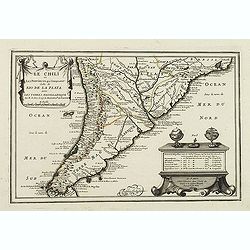
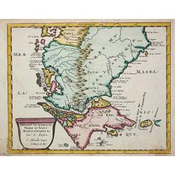
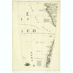
Le Chili et Les Provinces qui Composent Celle de Rio De La Plata avec Les Terres Magellanique. . .
Somewhat uncommon map of the southern part of South America, showing excellent detail along the River Plate and the Pacific Coast to the Andes mountains. Two globes and a...
Place & Date: Paris, 1705
Selling price: $170
Sold in 2011
Descripcion de la provincia de Chile.
Map of the Chile. Cartographic elements include topographical details and location of some rivers and settlements. The map was copied from the manuscript map of Juan Lóp...
Place & Date: Madrid, 1730
Selling price: $425
Sold in 2012
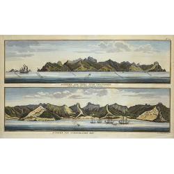
Aussicht der Insel Juan Fernandes/Aussicht von Cumberland Bay.
2 views on one sheet; with decorative views of the coast of Chile by the Admiral of the Fleet George Anson (1697 -1762), who was a Royal Navy officer.
Place & Date: London, ca. 1740
Selling price: $100
Sold in 2018
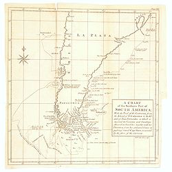
A Chart of the Southern Part of America, with the track of the Centurion. . .
A chart of the southern part of South America with the track of the Centurion from the Island of St Catherine to the Island of Juan Fernandes in which is inserted the var...
Place & Date: London, 1748
Selling price: $20
Sold in 2020
Le Chili.
Deatailed small map showing most part of Chile. Centered on Santiago. From Atlas Portatif Universel, by Robert de Vaugondy. 110 outside border top right. Mary Sponberg Pe...
Place & Date: Paris, later than 1749
Selling price: $65
Sold in 2014
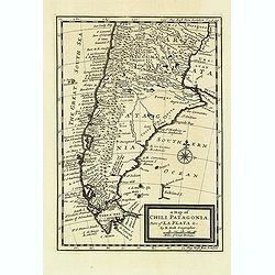
A map of Chili. Patagonia. Part of La Plata & C.
Detailed map showing the southern most part of South America's coastlines, including details of the Falkland Islands.
Place & Date: London, c.1750
Selling price: $140
Sold in 2012
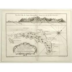
Vue de L'isle de Juan Fernandes. . .
A striking map of Juan Fernandez Island also known as Mas a Tierra. It is west of San Antonio, Chile in the South Pacific. It is thought to have inspired Robinson Crusoe....
Place & Date: Paris, 1758
Selling price: $35
Sold in 2020
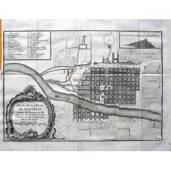
Plan de la ville de Santiago. . .
Early plan of Santiago de Chile, showing the squarish arranged streets, the Río Mapocho and its canals. A key identifies 23 churches and 5 important places on the map.
Place & Date: Paris, c1760
Selling price: $50
Sold in 2013
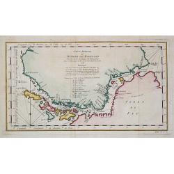
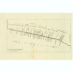
Carte réduite du Détroit de Magellan
Jaques Nicolas Bellin (1702-720) was the most important French hydrographer of the 18th century. Sea-atlas 'Hydrographique Français' , 1756-65, atlas to accompany Prévo...
Place & Date: Amsterdam, c. 1760
Selling price: $100
Sold in 2020
![Port Gallant et Baye Fortescue / Port Eimine /Baye de Wood / Baye et Havre de Cordes. [Tome I Pl. 3.]](/uploads/cache/25889-250x250.jpg)
Port Gallant et Baye Fortescue / Port Eimine /Baye de Wood / Baye et Havre de Cordes. [Tome I Pl. 3.]
Four charts on one sheet of Port Famine, Wood's Bay, Port Gallant and Fortescue Bay, Cordes Bay and Harbour. This print is taken from the first French edition of James Co...
Place & Date: Paris, 1774
Selling price: $80
Sold in 2012