Browse Listings in America > North America > North Pole
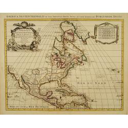
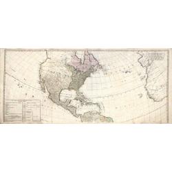
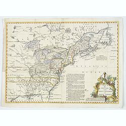
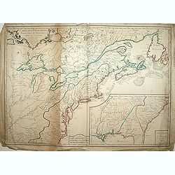
Carte d' Amerique Dressee pour l'Usage Du Roy. . .
Detailed copper-engraved map of Northern and Central America. Shows North America with colonial divisions and a wide open Northwest. The English settlements are confined ...
Place & Date: Amsterdam c. 1745
Selling price: $1400
Sold in 2018
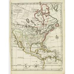
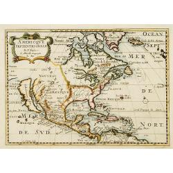
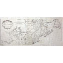
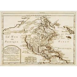
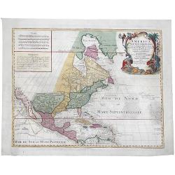
L'Amerique Septentrionale.
Interesting map of North America. In north eastern part of North America some interesting lakes and rivers are drawn, with a note: Terres vues par Tchirikow en 1741 . Tch...
Place & Date: Paris, 1746
Selling price: $150
Sold in 2017
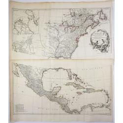
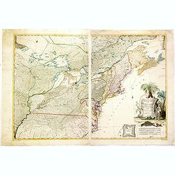
Amérique Septentrionale.
2 x 2 joined sheets.
Place & Date: Paris, 1746
Selling price: $750
Sold in 2009
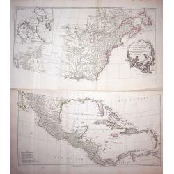
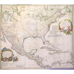
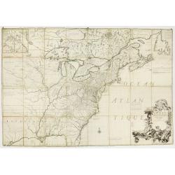
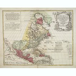
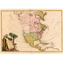
Amerique Septentrionale Publiee sous les Auspices de Monseigneur le Duc d'Orleans Premier Prince du Sang. . .
A large map of North America and the West Indies that was one of the best French maps of North America prior to the French & Indian War. This map provides good inform...
Place & Date: Paris, 1746
Selling price: $1100
Sold in 2019
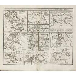
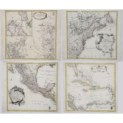
Particular Draughts and Plans of Some of the Principal Towns and Harbours Belonging to the English, French, and Spaniards, in America and West Indies
An unusual copper engraving by E. Bowen from 'A Complete System of Geography'. Featuring 13 small maps of colonial towns and sea ports of North America and the West Indie...
Place & Date: London, 1747
Selling price: $500
Sold in 2010
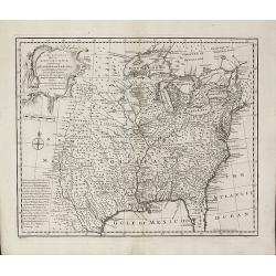
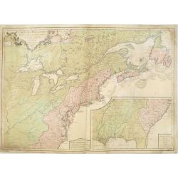
A New & Accurate Map of Louisiana, with Part of Florida and Canada, and the Adjacent Countries
Remarkable map of the British, Spanish & French Colonies in North America on the eve of the French & Indian War by E. Bowen from 'A Complete System of Geography'....
Place & Date: London, 1747
Selling price: $1000
Sold in 2011
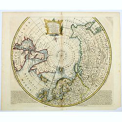
A NEW and Accurate Map of the North Pole, with all the Countries hitherto Discovered. . .
A spectacular Arctic and sub-Arctic map, showing excellent detail around Hudson Bay area, Greenland, Spitzbergen & the Northeast Coast of Europe & Asia. It depict...
Place & Date: London, 1748
Selling price: $300
Sold in 2021
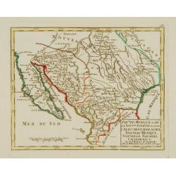
Partie du Mexique ou de la Nouv.le Espagne ouse trouve..
Fine miniature map of California Peninsular, Mexico till the Gulf of Mexico. Found in his Atlas Portatif, universel et militaire, 1749-1799.
Place & Date: Paris 1749
Selling price: $300
Sold
L'AMERIQUE SEPTENTRIONALE Dressée sur les Relations les plus modernes des Voyageurs. . .
Scarce first edition of De Vaugondy's large map of North America. The Coast of California still includes Nlle. Albion, Quiviera and the entrance discovered by Martin d'Au...
Place & Date: Paris, 1750
Selling price: $850
Sold in 2016
L'AMERIQUE SEPTENTRIONALE Dressée sur les Relations les plus modernes des Voyageurs. . .
Scarce first edition of De Vaugondy's large map of North America. The Coast of California still includes Nlle. Albion, Quiviera and the entrance discovered by Martin d'Au...
Place & Date: Paris, 1750
Selling price: $425
Sold in 2008
Accurata delineatio celeberrimae Regionis Ludovicianae ...
Includes the area from the Great Lakes to the Caribbean, and the basin of the river Mississippi in the centre of the map. Part of Louisiana in the top left inset. A very ...
Place & Date: Augsburg, 1750
Selling price: $1900
Sold in 2013
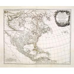
L\'AMERIQUE SEPTENTRIONALE Dressée sur les Relations les plus modernes des Voyageurs. . .
North America with inset of the Northwest including Nouvelle Albion, Strait of Anian, and other various fantastic possibilities of a Northwest Passage (Partie Nord-Ouest ...
Place & Date: Paris, 1750
Selling price: $400
Sold in 2013
The Continent and Islands of America are divided and Possessed as follows. . .
A copper engraved map. Top half sheet of a 2-sheet map only. Printed in lower left corner is a key showing which regions and islands belong to the United States and Great...
Place & Date: London, ca 1750
Selling price: $395
Sold in 2021
Amerique Septentrionale par N. Sanson.
Small decorative map of the Americas with a very large CALIFORNIA AS AN ISLAND.
Place & Date: Amsterdam 1752
Selling price: $250
Sold
North America, Performed under the Patronage of Louis Duke of Orleans, First Prince of the Blood. By the Sieur d'Anville. . .
A lovely copper engraved map from 'The Universal Dictionary of Trade and Commerce (vols. 1 & 2)', by Malachy Postlethwayt / published by Paul Knapton, London, in 1755...
Place & Date: London, 1752
Selling price: $600
Sold in 2020
AMERICAE SEPTENTRIONALIS ad emendatiora Exemplaria adhuc edita jussu Aca. Reg. Scjent et. Pars I to IV.
Complete set of Euler's four-part map of North America, published in response to the maps of Mitchell and D'Anville. Part I covers the region from the Mississippi River ...
Place & Date: Berlin, 1753
Selling price: $1000
Sold in 2017
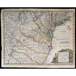
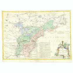
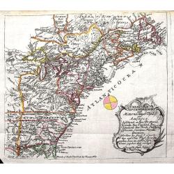
A Map of the British American Plantations extending from Boston in New England to Georgia. . .
A nice example of this early map of the British Colonies, issued just one year prior to the seminal map of John Mitchell. The map is based largely upon the work of D'Anvi...
Place & Date: London, 1754
Selling price: $240
Sold in 2019
Canada et Louisiane..
Uncommon map showing eastern part of the United States and Canada coast. Boundaries colored according key, indicating French, Spanish and English possessions. Small inset...
Place & Date: Paris 1755
Selling price: $1225
Sold
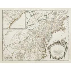
Partie de l\'Amerique septentrionale.. le cours de L\'Ohio..
From the Atlas Universel , a detailed map extending the length of the east coast from Penobscot Bay to Cape Fear and, in an inset, from Cape Fear to Fort St.Georges. This...
Place & Date: Paris, 1755
Selling price: $1100
Sold in 2008
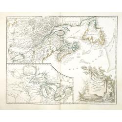
Partie de l'Amerique Septent. .
A fine copy of this map of New Foundland, Nova Scotia and the course of the St.Lawrence to Lake Ontario. An inset shows Bellini's famous and important map of the Great La...
Place & Date: Paris, 1755
Selling price: $950
Sold in 2014
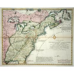
Nieuwe kaart van de Grootbrittannische volkplantingen ..
A wonderful map of the situation in North America at the beginning of the French & Indian War. By the middle of the eighteenth century, the French, who claimed the en...
Place & Date: Amsterdam 1755
Selling price: $700
Sold
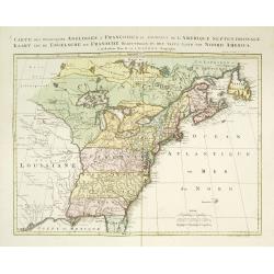
Carte des possessions Angloises et Françoises du continent de l'Amerique Septentrionale. / Kaart van de Engelsche en Fransche bezittingen . . .
A great French and Indian War map, with the states of Florida, Georgia, North and South Carolina, Virginia, Pennsylvania, Maryland, Jersey, New York, Connecticut, Massach...
Place & Date: Amsterdam, 1755
Selling price: $1500
Sold in 2019
Partie de l\'Amerique septent? Qui comprend la nouvelle France. . .
A fine copy of this map of New Foundland, Nova Scotia and the course of the St. Lawrence to Lake Ontario in a fourth state.An inset shows Bellini's famous and important m...
Place & Date: Paris, 1755
Selling price: $255
Sold in 2013
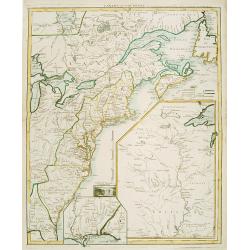
A Map of the British and French Settlements in North America.
An interesting and informative map highlighting (in green) the areas of dispute between England and France and the beginning of the French & Indian War. Explanatory n...
Place & Date: London, 1755
Selling price: $60
Sold in 2016
A Map of the British and French Settlements in North America.
An interesting and informative map highlighting the dispute (the shaded areas) between England and France at the beginning of the French & Indian War. Explanatory not...
Place & Date: London, 1755
Selling price: $215
Sold in 2019
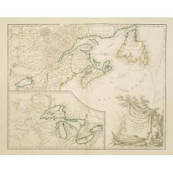
Canada Louisiane et Terres Angloises.
The two northern sheets of a four-sheet map featuring the Great Lakes, the upper Mississippi River and the Atlantic coast region. Large, decorative cartouche designed by ...
Place & Date: Paris, 1755
Selling price: $550
Sold in 2020
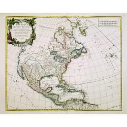
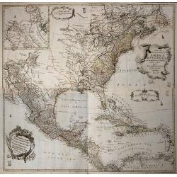
![CARTE DE L'AMERIQUE SEPTENTRIONALE, Depuis le 28 Degre...[Sea of the West]](/uploads/cache/85714-250x250.jpg)
CARTE DE L'AMERIQUE SEPTENTRIONALE, Depuis le 28 Degre...[Sea of the West]
A large and rare map that covers nearly all of North America, especially the USA. An important map of North America, with interesting geographical features: * Incorperati...
Place & Date: Paris, 1755
Selling price: $1500
Sold in 2021
Amerique Septentrionale avec les Routes, Distances en miles, Limites et Etablissements François et Anglois Par le Docteur Mitchel Traduit de 'Anglois..
First French edition of the famous John Mitchell map of the British and French Dominions in North America. Includes the word Limites in the title rather than Villages whi...
Place & Date: Paris 1756
Selling price: $10500
Sold
Carte des Possessions Françoises et Angloises dans le Canada et partie de la Lousiane. . .
First state, separately published. This map was published in 1756 to provide information on the French-Indian wars.
Place & Date: Paris, 1756
Selling price: $950
Sold in 2013
Carte des Possessions Françoises et Angloises dans le Canada et Partie de la Louisiana. . .
First state of this separately published map of the European Colonies in the New World east of the Mississippi River. This map was published in 1756 to provide informatio...
Place & Date: Paris, 1756
Selling price: $1000
Sold in 2021
Amérique Septentrionale divisée en ses principales..
A finely engraved map of North America, prepared by J.B.Nolin. The map is most notable for it's depiction of Mer de L'Quest or Sea of the West, a great sea, easily the si...
Place & Date: Paris c.1760
Selling price: $325
Sold
America Septentrionalis concinnata . . .
After the foundation map by de L'Isle published in 1700: which was the first map to reconnect California to the mainland and shows good detail for the Great Lakes and Hud...
Place & Date: Augsburg, 1760
Selling price: $600
Sold
Mappa Geographica Americae Septentrionalis ad Emendatiora Exemplaria adhuc Edita . . .
Printed from 4 plates and showing the northern half continent with the Caribbean. Copper engraved map with original outline color, printed from 4 plates, after Leonhard E...
Place & Date: Berlin c. 1760
Selling price: $800
Sold in 2014
America Septentrionalis concinnata...
A copperplate colored map of the north east America, that shows California as an island, after the foundation map by de L'Isle published in 1700, which was the first map ...
Place & Date: Augsburg, 1760
Selling price: $500
Sold in 2017
America septentrionalis oder Mitternachtiger theil von America bestehend in Neu Brittania, Canada, Neu Engeland, Neu Schotland, Neu Jorck, Pensylvania, Carolina, Florida, Georgien. . .
A rare German map of the East Coast of North America. Shows the British Colonies at the end of the Franco-Indian War, and extends from Newfoundland until Florida, and wes...
Place & Date: Augsburg, ca 1760
Selling price: $220
Sold in 2018
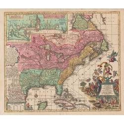
Theatrum belli in America Septentrionali. II. foliis comprehensum jussu Acad. Reg. Scient. et Eleg. Litt. exhibet I. C. Rhode Ac: Geogr.
Separately issued map of the northeastern part of the United States and Eastern Canada from the Mississippi Valley to the Atlantic Seaboard, published during the French a...
Place & Date: Berlin, 1761
Selling price: $6000
Sold in 2018
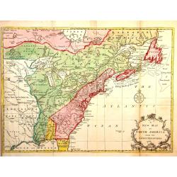
L'Amerique Septentrionale divisé en fes principaux.
A finely engraved map of North America, prepared by Janvier. The map is most notable for it's depiction of Mer de L'Quest or Sea of the West, a great sea, easily the size...
Place & Date: Paris 1762
Selling price: $750
Sold
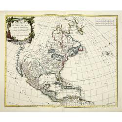
![L' AMERIQUE SEPTENTRIONALE divisee en les principaux ETATS.[Great western sea, First State]](/uploads/cache/82867-250x250.jpg)
L' AMERIQUE SEPTENTRIONALE divisee en les principaux ETATS.[Great western sea, First State]
First state for this very important map. Engraved by Lattré. This map is most notable for it's depiction of Mer de L'Quest or Sea of the West, near modern-day Seattle. A...
Place & Date: Paris, 1762
Selling price: $300
Sold in 2019
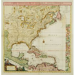
Carte Générale de l' Amérique Séptentrionale ..
Uncommon 3rd version of Le Rouge's Popple key map by Crepy. This state 3 is a variant of state 2 (from the same plate) except: title at top now states: CARTE GÉNÉRALE D...
Place & Date: Paris, ca. 1763
Selling price: $1650
Sold
A New map of North America from the latest discoveries 1763.
From London magazine, January 1763.
Place & Date: London, c.1763
Selling price: $200
Sold in 2013