Browse Listings in America > North America > New England states / Vermont / Maine
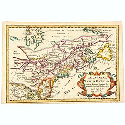
Le Canada, ou Nouvelle France, &c, tiree de diverses Relations des Francois, Anglois, Hollandois, &c. . .
A fine smaller map of the north eastern US seaboard, extending to the Great Lakes (shown as open-ended) and beyond into 'Upper Canada' by Nicolas Sanson, and originally f...
Place & Date: Utrecht, 162
Selling price: $420
Sold in 2021
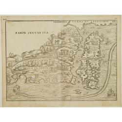
Nova Francia.
RARE FIRST STATE of the woodcut map of the Atlantic coastline from New York to Labrador. Manhattan as the peninsula "Angouleme", named after King Francis I, Duk...
Place & Date: Venice 1556
Selling price: $5100
Sold

Tierra Nueva.
Uncommon first edition of this early map of the east coast is an enlarged version of Giacomo Gastaldi map published in 1548. Nomenclature and cartography are unchanged, w...
- $1000 / ≈ €936
Place & Date: Venice, 1561
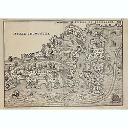
La Nuova Francia.
Second state of the woodcut map of the Atlantic coastline from New York to Labrador. Manhattan as the peninsula "Angouleme", named after King Francis I, Duke of...
Place & Date: Venice, 1565
Selling price: $2800
Sold in 2012
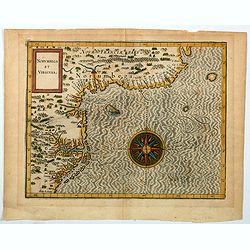
Norumbega et Virginia.
An important map that shows the east coast of North America from the Outer Banks of present day Carolina and on up to Canada. Chesapeake Bay is called "Chesipooc Sin...
Place & Date: Douai, 1607
Selling price: $2050
Sold in 2020
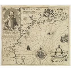
New England/ Die mercklichsten dheile. .
Hulsius used the first state of Smith's New England map published the previous year in London. The most noticeable differences, however, are the lack of any imprints lowe...
Place & Date: Frankfurt ,1617
Selling price: $8100
Sold in 2012
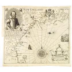
Die Mercklichsten Dheile, also Genennet durch den Durchl: und Mechtigen Prinzen und H.H. Carolus, Prinzen von Gross Britannien.
Hulsius used the first state of Smith's New England map published the previous year in London. The most noticeable differences, however, are the lack of any imprints lowe...
Place & Date: Frankfurt, 1617
Selling price: $10000
Sold
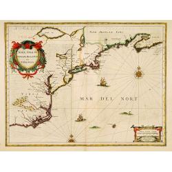
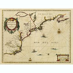
Nova Anglia Novum Belgium et Virginia.
In the 1636 edition of the Appendix , Johannes Janssonius inserted this important and influential map of the eastern seaboard from C. of Feare (Cape Look out) to Nova Sco...
Place & Date: Amsterdam, 1636
Selling price: $2100
Sold in 2019
Nova Anglia Novum Belgium et Virginia.
In the 1636 edition of the Appendix , Johannes Janssonius inserted this important and influential map of the eastern seaboard from C. of Feare (Cape Look out) to Nova Sco...
Place & Date: Amsterdam 1636
Selling price: $1800
Sold
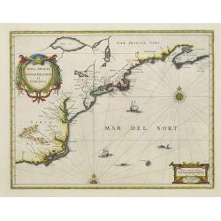
Nova Anglia Novum Belgium et Virginia.
In the 1636 edition of the "Appendix," Johannes Janssonius inserted this critical and influential map of the eastern seaboard from C. of Feare (Cape Lookout) to...
Place & Date: Amsterdam, 1636
Selling price: $2100
Sold in 2021