Browse Listings in America > North America > California / Northwest Central
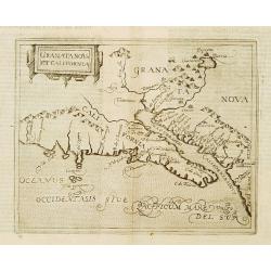
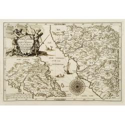
Granata Nova et California.
Very rare sixteenth century map: the second printed map devoted to the California peninsula and the south west of present day United States. A reduced version of the Corn...
Place & Date: Cologne 1598
Selling price: $1600
Sold
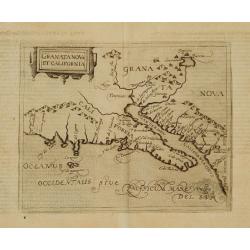
Granata Nova et California.
Very rare sixteenth century map: the second printed map devoted to the California peninsula and the south west of present day United States. A reduced version of the Corn...
Place & Date: Cologne 1598
Selling price: $1900
Sold
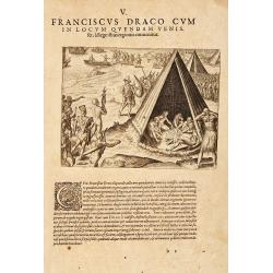
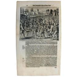
Franciscus Draco cum in locum quendam venis set, à Rege istius regionis convenitur.
This famous and desirable scene was engraved by de Bry native Americans approaching European soldiers and offer gifts. A group of native Americans sit around a fire in a ...
Place & Date: Frankfurt, Matthaeus Becker, 1599
Selling price: $300
Sold in 2014
![Tartariae Sive Magni Chami Regni typus. [Alaska and N.America West coast]](/uploads/cache/84445-250x250.jpg)
Tartariae Sive Magni Chami Regni typus. [Alaska and N.America West coast]
Important Map of Asia and North America Included in the World’s First Modern Atlas. It is the earliest obtainable map to name California and is one of the first to incl...
Place & Date: Antwerp, 1603
Selling price: $700
Sold in 2021
Tartariae sive magni regni...
An attractive old color example of this important map of Tartary, Japan, and the west coast of North America, from Ortelius' Theatrum Orbis Terarrum, the first modern at...
Place & Date: Amsterdam, 1608
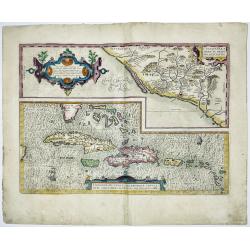
CULIACANAE,A MERICAE REGIO NIS, DESCRIPTIO - Hispaniolae, Cubae, Aliarumique Insularum Circumiacientium Delineatio
CULIACANAE, A MERICAE REGIO NIS, DESCRIPTIO - Hispaniolae, Cubae, Aliarumique Insularum Circumiacientium Delineatio.Antique map of the Caribbean. Two maps on one sheet: ...
Place & Date: Antwerp, 1603-1612
Selling price: $400
Sold in 2023

Tartariae sive Magni Chami Imperium.
This is a very early depiction of the northern Pacific, with the first mapping of Northwest Coast of America and probably the first map to name California 'C. Califormio...
- $2500 / ≈ €2339
Place & Date: Antwerp, c. 1608-1612
![[Sir F. Drake crowned by the Indians of Nova Albion] / [Europeans, Drake, and the King of Ternate].](/uploads/cache/41100-250x250.jpg)
[Sir F. Drake crowned by the Indians of Nova Albion] / [Europeans, Drake, and the King of Ternate].
First engraving: Native Americans approach European soldiers and offer gifts. A native king or ruler wearing a feathered headdress puts a crown on a man's head who holds ...
Place & Date: Frankfurt, M.Merian, 1633
Selling price: $90
Sold in 2018
Sir Francis Drake crowned King of California.
Rare 1655 view of Sir Francis Drake, English soldiers paraded and planting the flag while native Californians celebrate and place a crown on Drake's head. From "Newe...
Place & Date: Frankfurt, 1655
Selling price: $350
Sold in 2015
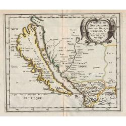
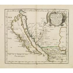
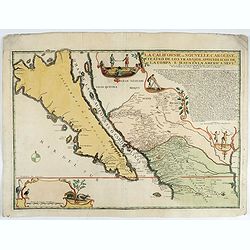
Audience de Guadalajara, Nouveau Mexique, Californie, &c.
Map of California, shown as an island, from the first edition of the atlas L'Amérique en plusieurs cartes, et en divers traittés de Géographie, et d'Histoire.Nicolas S...
Place & Date: Paris, 1657
Selling price: $1400
Sold in 2012
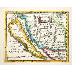
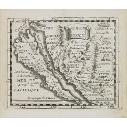
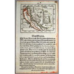
Nouveau Mexique.
Piere du Val (1618-83), Paris-based cartographer and publisher. Atlases a.o. 'Cartes de Géographie', 1654-88, 'La Géographie universelle', 1661-1712. After his death, h...
Place & Date: Paris, 1661.Paris, 1661
Selling price: $350
Sold in 2008
![Pascaerte van NOVA HISPANIA PERV en CHILI [California as an island].](/uploads/cache/97818-250x250.jpg)
Pascaerte van NOVA HISPANIA PERV en CHILI [California as an island].
California as an island on second Sanson model, with indented northern coast. Agubela de Cato is peninsula to its north.Possibly copied from Blaeu's map of 1648, as was D...
Place & Date: Amsterdam, 1666
Selling price: $1800
Sold in 2020
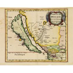
Audience de Guadalajara nouveau Mexique, Californie. &c.
A finely engraved map of California and New Mexico. Prior to this map, all maps with California shown as an Island were either World maps, Western Hemisphere, North Ameri...
Place & Date: Paris, P. Marriete, 1667
Selling price: $1000
Sold in 2016
![Noweav Mexiqve. [California as an Island]](/uploads/cache/07724-250x250.jpg)
Noweav Mexiqve. [California as an Island]
Uncommon miniature map of California as a island, from Pierre Duval's La Géographie Universelle dated 1676. The map is derived from Audience de Guadalajara , 1657, by hi...
Place & Date: Paris, 1672
Selling price: $600
Sold in 2016
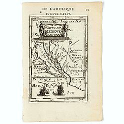
Noweau Mexique.
Uncommon miniature map of New Mexico from Pierre Duval\'s La Geographie Universeille. Following his Cartes de geographie in 1657, Pierre Duval published this smaller size...
Place & Date: Paris, 1676
Selling price: $400
Sold in 2008
Audience de Guadalajara nouveau Mexique, Californie. &c.
From Sanson's Geographia Exactissima. A finely re-engraved Amsterdam version of Sanson's map of California and New Mexico, first published in 1657, which was the earliest...
Place & Date: Amsterdam 1682
Selling price: $1200
Sold
Nouveau Mexique et Californie.
A charming map of California as an Island. The title cartouche is flanked by two native figures and two ships engaged in battle at bottom. . Title in curtain draped at to...
Place & Date: Paris, 1683
Selling price: $300
Sold in 2020
Nouveau Mexique et Californie.
A charming late 17th century French map of California, Nueva Granada and Nouvelle Espagne. California with flat northern coast, labelled Isle de Calfornie. A unique proje...
Place & Date: Franckfurt 1684
Selling price: $285
Sold
Nouveau Mexique et Californie.
A charming late 17th century French map of California, Nueva Granada and Nouvelle Espagne. California with flat northern coast, labelled Isle de Calfornie. A unique proje...
Place & Date: Franckfurt 1684
Selling price: $325
Sold
Nouveau Mexique et Californie.
A charming late 17th century French map of California, Nueva Granada and Nouvelle Espagne. California with flat northern coast, labeled Isle de Calfornie. A unique projec...
Place & Date: Frankfurt, 1684
Selling price: $205
Sold in 2008
Nouveau Mexique et Californie.
A charming late 17th century French map of California, Nueva Granada and Nouvelle Espagne. California with flat northern coast, labeled Isle de Calfornie. A unique projec...
Place & Date: Frankfurt, 1684
Selling price: $225
Sold in 2008
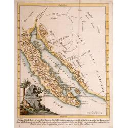
The Island of California.
A rare miniature map focusing on the large Island of California, in original outline color. An example of the first state. Inaccurately and extensively detailed with moun...
Place & Date: Ulm, 1692
Selling price: $325
Sold in 2017
![[Neu Mexico]](/uploads/cache/40499-250x250.jpg)
[Neu Mexico]
A rare miniature map of California and Nova Mexico, published by Johann Ulrich Muller in Ulm .This attractive map shows the island of California and the contiguous parts ...
Place & Date: Ulm, 1692
Selling price: $220
Sold in 2018
![[Neu Mexico]](/uploads/cache/43923-250x250.jpg)
[Neu Mexico]
A rare miniature map of California and Nova Mexico, published by Johann Ulrich Muller in Ulm .This attractive map shows the island of California and the contiguous parts ...
Place & Date: Ulm, 1692
Selling price: $325
Sold in 2020
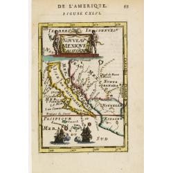
Cette Carte de Californie et du Nouveau Mexique ?
A most important map, identifying by numerical code some 314 places in New Mexico, and showing in detail California as an island, although based on Sanson's monumental ma...
Place & Date: Paris, 1700
Selling price: $1000
Sold in 2009
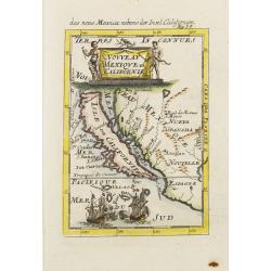
Cette Carte de Californie et du Nouveau Mexique.
A most important map, identifying by numerical code some 314 places in New Mexico, and showing in detail California as an island, although based on Sanson's monumental ma...
Place & Date: Paris, 1700
Selling price: $735
Sold in 2013
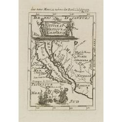
![Cette Carte DE CALIFORNIE et DU NOUVEAU MEXIQUE.[Rare 1st edition!]](/uploads/cache/83264-250x250.jpg)
Cette Carte DE CALIFORNIE et DU NOUVEAU MEXIQUE.[Rare 1st edition!]
Rare and important map of California ,New Mexico and New Spain, showing in detail California as an island [San Francisco, San Diego and Mendocino are mentioned among many...
Place & Date: Paris 1700
Selling price: $850
Sold in 2021
Delineatio Nova Et Vera Partis Australis Novi Mexici.
Attractive map of the Southern Portion of Baja California and contiguous Mexico, based in part on Scherer's correspondence with Fra. Eusebio Kino, the Jesuit Missionary c...
Place & Date: Munich c.1702
Selling price: $320
Sold
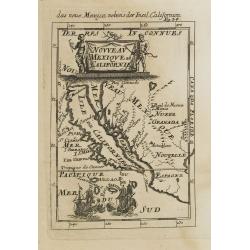
Cette Carte de Californie et du Nouveau Mexique. . .
A most important map, identifying by numerical code some 314 places in New MexicoIt shows in detail California as an island, although based on Sanson's monumental map of ...
Place & Date: Paris, 1705
Selling price: $1900
Sold in 2008
Cette Carte de Californie et du Nouveau Mexique.
A most important map, identifying by numerical code some 314 places in New Mexico, and showing in detail California as an island, although based on Sanson's monumental ma...
Place & Date: Paris, 1705
Selling price: $1200
Sold
Cette Carte de Californie et du Nouveau Mexique.
A most important map, identifying by numerical code some 314 places in New Mexico, and showing in detail California as an island, although based on Sanson's monumental ma...
Place & Date: Paris, 1705
Selling price: $750
Sold in 2015
Cette Carte de Californie et du Nouveau Mexique.
A most important map, identifying by numerical code some 314 places in New Mexico, and showing in detail California as an island, although based on Sanson's monumental ma...
Place & Date: Paris, 1705
Selling price: $750
Sold in 2019
Cette Carte de Californie et du Nouveau Mexique . . .
A most important map, identifying by numerical code some 314 places in New Mexico, and showing in detail California as an island, although based on Sanson's monumental ma...
Place & Date: Paris, 1705
Selling price: $750
Sold in 2020
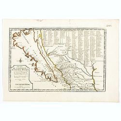
La Californie ou Nouvelle Caroline.
This fine rare map is a reissue of de Fer's map of 1705 but on a larger scale, and with some notable additions. A boldly engraved and handsome item, the largest scale map...
Place & Date: Paris, 1720
Selling price: $5600
Sold in 2022
![Carte du Gouvernement de l' Amerique [California Island].](/uploads/cache/82994-250x250.jpg)
Carte du Gouvernement de l' Amerique [California Island].
An interesting chart depicting the European possessions in North and South America. A wonderful example of Chatelain’s elegant maps. Included in the 1721 edition of the...
Place & Date: Amsterdam, 1721
Selling price: $120
Sold in 2019
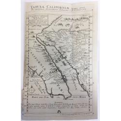
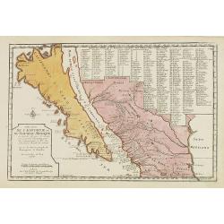
Tabula Californiae Anno 1702 ex Autoptica Observatione Delineata a R.P. Chino e S.I.
Map of California based on Kino's map, originally drawn in 1702. Kino's map carefully records the results of nine journeys he made in northwestern Mexico and along the Co...
Place & Date: Augsburg, 1726
Selling price: $750
Sold in 2019
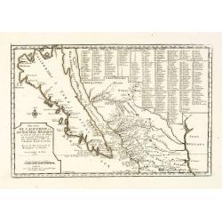
![Tabula Californiae, Anno 1702 … Ex autoptica observatione delineata a R.P. Chino e S.I. [The Map of California in 1702 as Observed and Drawn by Father Chino, S. J.]](/uploads/cache/85891-250x250.jpg)
Tabula Californiae, Anno 1702 … Ex autoptica observatione delineata a R.P. Chino e S.I. [The Map of California in 1702 as Observed and Drawn by Father Chino, S. J.]
The much sought after so-called KINO-map of California as a peninsula, a result of Father Kino's travels which misspelled the island-phantasy. This his second map is...
Place & Date: Augsburg & Graetz, 1726
Selling price: $600
Sold in 2021
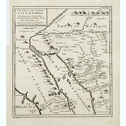
Passage par Terre a la Californie ..
Father Kino's important map was the first map to accurately depict the region, in particular the relative positions of the Colorado and Gila rivers and the correct locali...
Place & Date: Paris, 1727
Selling price: $275
Sold in 2011
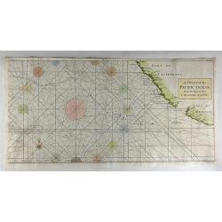
A Chart of the Pacific Ocean from the Equinoctial to the Latitude of 39 1/2d No.
This is a rare nautical chart of part of the Pacific Ocean displaying the routes of Spanish galleons between Acapulco and the Philippines. The tracks of the Spanish Nostr...
Place & Date: London, 1748
Selling price: $95
Sold in 2017
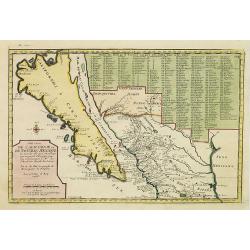
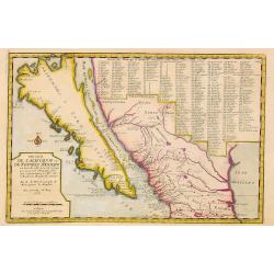
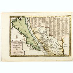
CALIFORNIA per P.Ferdinandum Con sak S.I. et alias.
Map of Mexico and the peninsular of California. Underneath the print a note about the region. Lower left a monogram E.V. of the engraver.
Place & Date: c. 1750
Selling price: $180
Sold