Browse Listings in America > Central America
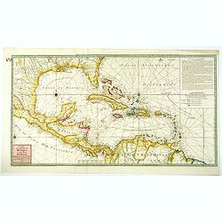
Carte du Golphe du Mexique et des Isles Antilles reduite de la grande Carte Anglois de Popple.
A good example of the 1780 Dezauche edition of Buache's most important map of the West Indies. Centered primarily on Cuba, this substantial map covers all of Central Amer...
Place & Date: Paris, 1780
Selling price: $650
Sold in 2021
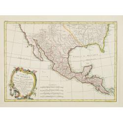
Carte du Mexique ou de la Nlle. Espagne..
Attractive map centered on Mexico, covering the whole Central America and the southern part of the United States.Ornated with a rococo title cartouche. Boundaries outline...
Place & Date: Paris, ca 1783
Selling price: $350
Sold in 2008
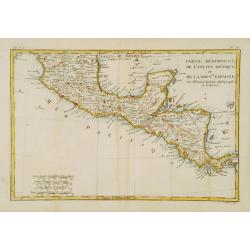
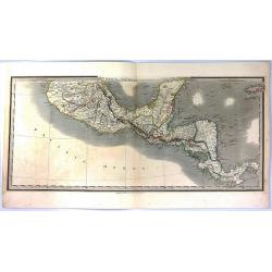
Partie Méridionale, de l'Ancien Méxique ou de la Nouv.le Espagne.
Copper engraved map of southern Mexico and all of Central America. Fine detail including shoals and navigational hazards along the coasts. Prepared by R.Bonne and include...
Place & Date: Paris 1787
Selling price: $50
Sold

The Coast of Yucatan from Campeche to Ascension Bay with the West End of Cuba, ...
Double page sea chart showing the Yucatan Peninsula to the lower edge, the western tip of Cuba shown to the right edge. A quartered compass rose shown to lower right corn...
Place & Date: London, Laurie and Whittle. 1794
Selling price: $351
Sold in 2020
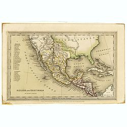
Mexico and Guatimala. By Thomas Starling.
A map that has Central America split into two regions; one outlined in red, the other in yellow. This is when Mexico still had possession of large swathes of California, ...
Place & Date: London, ca. 1835
Selling price: $45
Sold in 2019
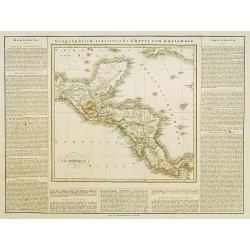
Mexico and Guatemala, Shewing the position of the Mines.
A large map of Central America extending from the southern half of Mexico to Panama, and including the Grand Cayman and Jamaica. This is the separate Central American map...
Place & Date: London, 1841
Selling price: $12
Sold in 2016
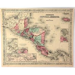
Johnson's Central America
A very pleasing map of Central America and Jamaica. Original hand colors surrounded by the usual fretwork border. From "Johnson's Atlas" by Johnson & Ward.
Place & Date: New York, 1856
Selling price: $31
Sold in 2017
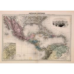
Amérique Centrale.
Decorative map of Central America from "Géographie Universelle, Atlas Migeon." published by J. Migeon. Nice steel engraving at the upper right hand of a view o...
Place & Date: Paris, 1874
Selling price: $80
Sold in 2014
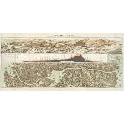
Panama Canal, Topographic, Diagramatic, and Illustrative.
Drawn in 1903, this "Topographic, Diagramatic, and Illustrative Map of the Panama Canal" illustrates the project for U.S. readers. The top panel depicts the exc...
Place & Date: Washington, D. C., 1903
Selling price: $300
Sold in 2009
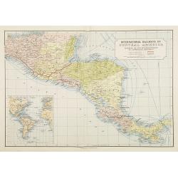
International Railways of Central America (chemins de fer internationaux de l'Amérique centrale).
Two colorful maps, a large one showing the railway systems in Central America by "International Railways of Central America" with a key to the ones unde...
Place & Date: London, ca. 1910
Selling price: $25
Sold in 2009
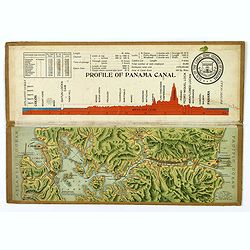
Souvenir Model of the Panama Canal.
A beautiful small profile map, on folding cardboard of the Panama Canal, by Maduro. The map is in raised profile, fully colored, and mounted on to original cardboard. The...
Place & Date: Panama, 1911
Selling price: $225
Sold in 2019
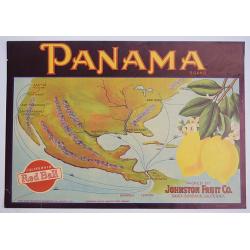
Panama.
A color printed vintage Panama Brand Lemon Crate Label, California Red Ball, Packed by Johnston Fruit Company, Santa Barbara, California.
Place & Date: Sacramento, 1912
Selling price: $15
Sold in 2019
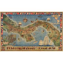
Republic of Panama with the Canal Zone
This striking large decorative map of Panama was created in 1941, just before the outbreak of WWII. when the canal under US control. Starting in 1903, a large area of ce...
Place & Date: Seattle, 1940
Guatemala.
This is the map of Guatemala is from a Plano edition of the very scarce German edition of Carey & Lea's "A Complete Historical, Chronological, and Geographical A...
Place & Date: Weimar, 1822-25
Selling price: $80
Sold
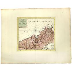
KAART van de LANDENGTE van PANAMA.
A detailed hand colored map of Panama, published in Amsterdam by Isaak Tirion. It depicts the City of Panama at the southeast, Chagres at the northwest and Porto-Bello at...
Place & Date: Amsterdam, ca 1745
Selling price: $150
Sold in 2019
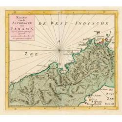
Kaart van de Landengte van Panama.
Izaak Tirion (d. 1769) Amsterdam publisher. His ' Nieuwe en beknopte handatlas' saw 6 editions between before 1740 and after 1784. Also ' Tegenwoordige staat van alle vol...
Place & Date: Amsterdam, c. 1745.
Selling price: $120
Sold in 2015