Browse Listings in America > Caribbean & Atlantic Ocean > Cuba
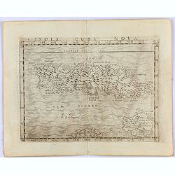
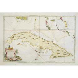
Insula Cuba Nova.
One of the earliest separately published maps of Cuba, with the Yslas de Lagartos (Cayman Islands). The map includes early appearances of Iamayea (Jamaica), Isola Espanol...
Place & Date: Venice, 1548
Selling price: $900
Sold in 2021
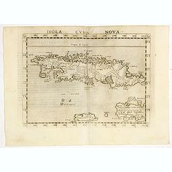
Isola Cuba Nova.
Scarce FIRST edition of this map depicting the island of Cuba - one of the earliest separately published maps of Cuba. Also includes Jamaica and northwestern Hispaniola a...
Place & Date: Venice, 1561
Selling price: $300
Sold in 2020
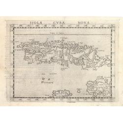
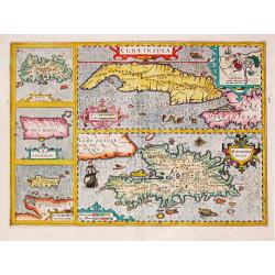
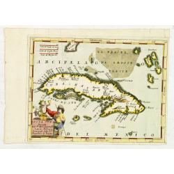
Isola Cuba Nova
This important Ruscelli map of Cuba from his work La Geografia di Claudio Tolomeo Alessandrino, is based on Gastaldi’s earlier map of the same region, dated 1548. Altho...
Place & Date: Venice, 1570
Selling price: $375
Sold in 2023
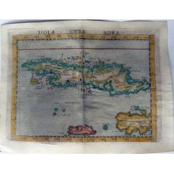
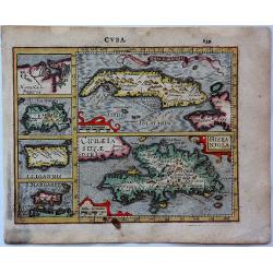
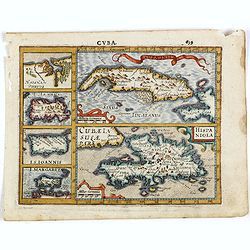
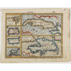
ISOLA CUBA NOVA.
One of the earliest separately published maps of Cuba. Also includes Jamaica and northwestern Hispaniola and the Cayman Islands. The map is elegantly designed and engrave...
Place & Date: Venice, 1574
Selling price: $1400
Sold in 2021
![[Cuba]](/uploads/cache/32579-250x250.jpg)
[Cuba]
On recto a wood block printed map of Cuba (79x123mm.).From a Latin text edition of his Geographia , that great compendium of Renaissance knowledge.
Place & Date: Basle, 1550-1590
Selling price: $190
Sold in 2013
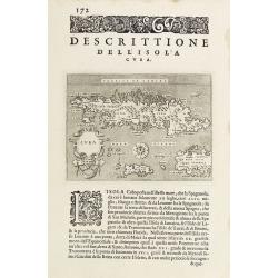
Descrittione dell'Isola Cuba.
Early map of Cuba, published in Venetia, Appresso gli Heredi di Simon Galignani, 1590.
Place & Date: Venise 1590
Selling price: $225
Sold
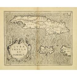
Cuba Insula et Jamaica.
One of only two Caribbean maps in this important work, which was one of the first atlases to provide detailed maps on the individual regions in the New World. The map is ...
Place & Date: Louvain, 1597
Selling price: $300
Sold in 2012
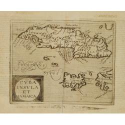
Cuba Insula et Iamaica.
Very rare sixteenth century map of Cuba, in lower part JamaicaPublished in the German edition of José de Acosta's De Natura Nova Orbis, first published in Salamanca, 158...
Place & Date: Cologne 1598
Selling price: $1400
Sold
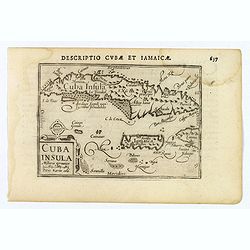
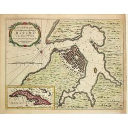
Cuba Insula.
This lovely miniature map shows the Caribbean Islands of Cuba and Jamaica. Published by Petrus Bertius, in Amsterdam at the beginning of the seventeenth century, this map...
Place & Date: Amsterdam, 1606
Selling price: $170
Sold in 2020
Cuba.
An attractive copper engraved map of Cuba & the Caribbean islands from Mercator's "Atlas Minor", with larger images of Cuba and Hispaniola, and four smaller...
Place & Date: Amsterdam, 1607
Selling price: $85
Sold in 2017
-250x250.jpg)
Hispaniolae, Cubae Alliarumique Insularium
Abraham Ortelius (1527-98), Dutch cartographer and publisher of the first modern atlas, ' Theatrum Orbis Terrarum' in 1570. Editions till 1612. Also an atlas of ancient c...
Place & Date: Antwerp, 1609
Selling price: $250
Sold in 2022
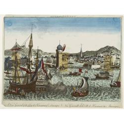
![[Two items] Abbildung Welcher Gestalt die Spanische Silberflota von dem Hollandischen / Das Eylandt Cuba mit Deroselben Gelegenheit](/uploads/cache/23421-250x250.jpg)
[Two items] Abbildung Welcher Gestalt die Spanische Silberflota von dem Hollandischen / Das Eylandt Cuba mit Deroselben Gelegenheit
An etching showing Piet Heyn going ashore at Cuba on a sheet with letterpress. Together with a scarce engraving of the Dutch and Spanish fleets in Patanca Bay, Cuba illus...
Place & Date: Frankfurt, 1627
Selling price: $650
Sold in 2008
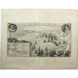
VEROVERING VANDE SILVER-VLOOT INDE BAY MATANCA.
Conquest of the treasure fleet in the Bay of Matanzas by a fleet of the WIC commanded by Admiral Piet Heyn, September 8, 1628. Bottom left a map of the island of Cuba. Ro...
Place & Date: Amsterdam, 1628
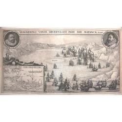
Verovering vande Silver-Vloot inde Bay Matanca. Anno 1628.
A scarce and important depiction of the taking of the Spanish silver fleet by the Dutch naval force in Matanzas Bay, Cuba. It includes the portraits of the Dutch commande...
Place & Date: Amsterdam, 1629
Selling price: $600
Sold in 2015
Cuba Insula. Hispaniola.
Decorative engraved map of Cuba above Hispaniola with smaller insets of Havana, Jamaica, Puerto Rico and Margarita.From the first French-text edition of Jodocus Hondius' ...
Place & Date: Amsterdam, ca. 1630
Selling price: $200
Sold in 2016
Cuba Insula / Hispaniola insula, insets: Havanna portus, celeberrimus totius indiae Occidentalis; Insula Iamaica; Ins. S. Ioannis; Ins. Margareta Cum Confinijis.
A most decorative map of the main Carabean islands from the Mercator / Hondius Atlas. Embellished with seven strapwork cartouches. Ref.: Koeman, Atlantes Neerlandici,...
Place & Date: Amsterdam, c. 1630
Selling price: $420
Sold in 2022
Cuba Insula. Hispaniola.
Decorative engraved map of Cuba above Hispaniola with smaller insets of Havana, Jamaica, Puerto Rico and Margarita.
Place & Date: Amsterdam, ca. 1630
Selling price: $150
Sold in 2015
![[lot of 8 maps/ prints of the Caribbean] Cuba Insula, inset: Havanna portus; Hispanolia Insula; Insula Iamaica; Ins. S. Ioannis; I.s. Margareta.](/uploads/cache/20279-(4)-250x250.jpg)
[lot of 8 maps/ prints of the Caribbean] Cuba Insula, inset: Havanna portus; Hispanolia Insula; Insula Iamaica; Ins. S. Ioannis; I.s. Margareta.
Re-issue of Gerard Mercator's small atlasA lot of 8 maps and prints of the Caribbean.
Place & Date: Amsterdam, 1630-1636
Selling price: $120
Sold in 2022

Afbeeldinge in Wat Manier de Silver Vloot Vanden Generael Pieter Pietersen Heyn Veroovert is Anno 1628.
Decorative view showing the Dutch capture of the Spanish silver fleet in the Bay of Matanzas (Cuba) in 1628. With the portrait of Admiral Hein, who captured over eleven m...
Place & Date: Amsterdam, c1650
Selling price: $160
Sold in 2015
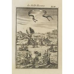
Havana.
Impressing copper engraving depicting the Havana harbour.
Place & Date: Amsterdam, 1671
Selling price: $450
Sold
Havana.
This wonderful engraving is a superb example of Ogilby's city views. Although it is a spectacular and lively composition, the image is a little inaccurate in detail. In t...
Place & Date: London, ca 1671
Selling price: $110
Sold in 2022
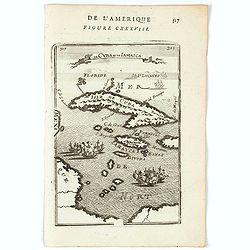
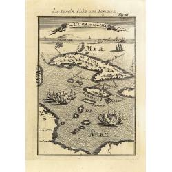
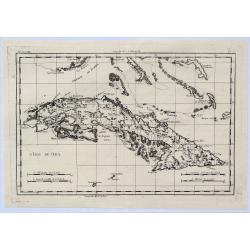
Is. De Cuba et Jamaica.
A charming little map of the islands of Cuba and Jamaica with on the horizon the tip of Florida and to the South and West part of the coast of Mexico. Two fleets of ships...
Place & Date: Paris, 1683
Selling price: $45
Sold in 2020
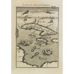
Is. De Cuba et de Jamaica.
A charming late 17th century French map of Cuba and Jamaica.By Allain Manneson Mallet (1630-1706), a well traveled military engineer and geographer who worked in 17th cen...
Place & Date: Paris, 1683
Selling price: $135
Sold
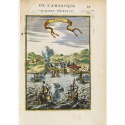
Havana.
Handsome view of the Havana harbour, assaulted by several vessels. Title garland on top.From the French text edition of Description d'Univers, 1683. by Allain Manneson Ma...
Place & Date: Paris 1683
Selling price: $50
Sold
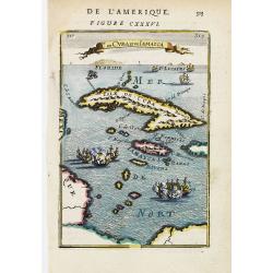
Is. De Cuba et de Jamaica.
A charming late 17th century French map of Cuba and Jamaica.By Allain Manneson Mallet (1630-1706), a well travelled military engineer and geographer who worked in 17th ce...
Place & Date: Paris 1683
Selling price: $105
Sold
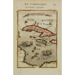
I.de Cuba et de Jamaica.
Map showing the islands of Cuba and Jamaica. The map is inserted in a prospective view of the Caribbean Sea, where some vessels are involved in a naval combat.From the Fr...
Place & Date: Frankfurt, 1684
Selling price: $150
Sold in 2013

Havana.
Handsome view of the Havana harbour, assaulted by several vessels. Title garland on top.From the French text edition of Description d'Univers, 1683. by Allain Manneson Ma...
Place & Date: Frankfurt, 1684
Selling price: $65
Sold in 2008
I.de Cuba et de Jamaica.
Map showing the islands of Cuba and Jamaica. The map is inserted in a prospective view of the Caribbean Sea, where some vessels are involved in a naval combat.From the Fr...
Place & Date: Frankfurt, 1684
Selling price: $65
Sold in 2008
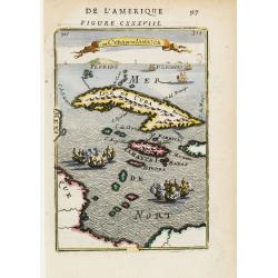
Is. De Cuba et de Jamaica.
A charming late 17th century French map of Cuba and Jamaica.By Allain Manneson Mallet (1630-1706), a well traveled military engineer and geographer who worked in 17th cen...
Place & Date: Franckfurt 1684
Selling price: $95
Sold
Havana.
Handsome of Havana and its harbour, assaulted by several vessels. Title garland on top.From the French text edition of Description d'Univers, 1683. by Allain Manneson Ma...
Place & Date: Frankfurt, 1684
Selling price: $100
Sold
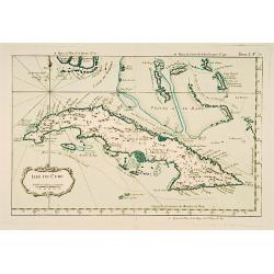
Isola Cuba Descritta dal P. Mro Coronelli
This scarce, attractive map centers on Cuba, and also shows the lower Bahamas and the Cayman Islands. Most detail is confined to the coastlines. The map is decorative wit...
Place & Date: Venice, 1692
Selling price: $180
Sold in 2012
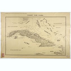
Kaart van Cuba. Bijvoegsel behoorende bij het 2e blad van de nieuwe Rotterdamsche Courant van Vrijdag 6 Mei 1898.
Lithographed map of Cuba, including southern tip of Florida with the Keys and the Bahama Islands. Several folds as issued, some underlaid with archival tape. Published as...
Place & Date: Rotterdam, 1698
Selling price: $30
Sold in 2017
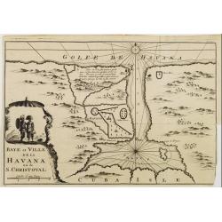
Baye et Ville de La HAVANA ou de S. CHRISTOVAL.
Attractive map centred on the town Havana and its large bay.
Place & Date: Amsterdam 1722
Selling price: $130
Sold
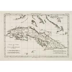
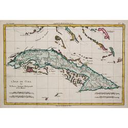
L'Isle de Cuba.
Detailed map of Cuba. Finely engraved with many soundings on banks. Numerous coastal place names. Several tracks noted. The Florida keys and the Bahamas are included.Jacq...
Place & Date: Paris, 1750
Selling price: $110
Sold
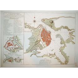
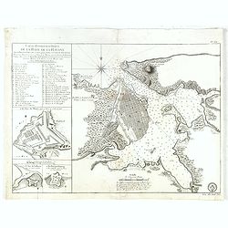
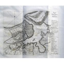
Carte Hydrographique de la Baye de la Havane
A beautifully engraved and detailed chart of the bay of Havana and plan of the city itself. Includes three inset plans of Havana's principal fortifications and a 45 point...
Place & Date: Paris, ca 1760
Selling price: $1000
Sold
![Carte Reduite de L'Isle de Cube [Cuba]. Dressee au Depoit des Cartes et Plans de la Marine. . .](/uploads/cache/84494-250x250.jpg)
Carte Reduite de L'Isle de Cube [Cuba]. Dressee au Depoit des Cartes et Plans de la Marine. . .
A well engraved and highly detailed nautical chart of Cuba. It shows soundings, anchorage's, channels, shoals, navigational sightings. Also shows small parts of Florida a...
Place & Date: Paris, 1760
Selling price: $700
Sold in 2021
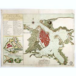
Carte Hydrographique de la Baye de la Havane.. N° 69.
A well engraved and highly detailed of the walled city of Havana and its harbor features inset plans of three forts (La Punta, El Morro, and La Real Fuerza) as well as a...
Place & Date: Paris, 1762
Selling price: $600
Sold in 2018
Carte Hydrographique de la Baye de la Havane.. N° 69.
A well engraved and highly detailed of the walled city of Havana and its harbor features inset plans of three forts (La Punta, El Morro, and La Real Fuerza) as well as a...
Place & Date: Paris, 1762
Selling price: $385
Sold in 2016
Carte Réduite De L'Isle De Cube..
A well engraved and highly detailed chart that was issued in Neptune americo-septentrionale. This chart is based on Sayer & Bennett's chart that was issued in 1776 an...
Place & Date: Paris, 1762
Selling price: $1200
Sold
Piano della Città e Porto dell' Havana.
An interesting map of Havanna, with its harbour, drawn by Giuseppe Pazzi and engraved by Violanta Vanni for Coltellinis Il Gazzettiere Americano.With numerous depth sound...
Place & Date: Livorno, 1763
Selling price: $140
Sold in 2017
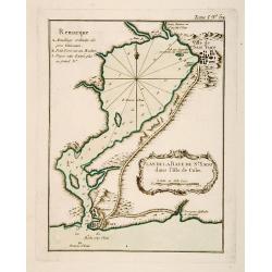
Plan de la Baye de St. Yago dans l'Isle de Cube.
This chart shows the territories and Bay of St. Yago on the island of Cuba.The only issue of this version of Bellin's map, slightly larger than the common version. Depths...
Place & Date: Paris 1764
Selling price: $80
Sold
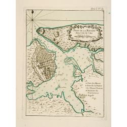
Port de la Havane dans l'Isle de Cube .
This chart shows the territories of the town and harbour of Havana on the island of Cuba.The only issue of this version of Bellin's map, slightly larger than the common v...
Place & Date: Paris 1764
Selling price: $130
Sold
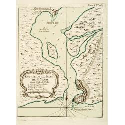
Entrée de la Baye de St Yago dans l'Isle de Cube.
This chart shows the bay of St Yago on the island of Cuba.The only issue of this version of Bellin's map, slightly larger than the common version. Depths shown by soundin...
Place & Date: Paris 1764
Selling price: $60
Sold
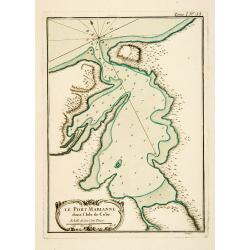
Le Port Marianne dans l'Isle de Cube.
This chart shows the bay of the harbour of Marianne on the island of Cuba. The only issue of this version of Bellin's map, slightly larger than the common version. Depths...
Place & Date: Paris 1764
Selling price: $80
Sold
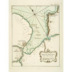
Baye de Matance dans l'Isle de Cube.
This chart shows the Bay of Matance on the island of Cuba.The only issue of this version of Bellin's map, slightly larger than the common version. Depths shown by soundin...
Place & Date: Paris 1764
Selling price: $100
Sold
Isle de Cube.
This chart shows the island of Cuba.The only issue of this version of Bellin's map, slightly larger than the common version. Depths shown by soundings.From Bellin's Petit...
Place & Date: Paris 1764
Selling price: $200
Sold

A Plan of the City and Harbour of Havanna, Capital of the Island of Cuba.
A lovely small town plan of the Cuban capital city of Havana, probably published by Baldwin for the "London Magazine" in the mid 1760s. The plan highlights the ...
Place & Date: London, ca 1765
Selling price: $65
Sold in 2020
An exact Plan of the City, Fortifications & Harbour of Havana in the Island of Cuba.
John Hinton (fl.1745, d. 1781), London-based publisher, Universal Magazin 1747-1781. A plan of the town of Havana and direct vincinity. With an inset depicting Cuba. From...
Place & Date: London, Newgate Street, 1752-1765
Selling price: $300
Sold in 2008
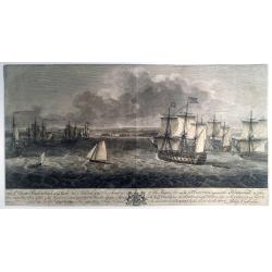
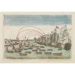
TO S,,r George Pocock KNIGHT of the BATH and Admiral of the Blue Squadron of His Majesty’s Fleet, on the EXPEDITION against the Havannah in 1762, / This PERSPECTIVE VIEW of the Harbour, with the LAND to the West, the MORO CASTLE to
A large, rare view of the British fleet entering the harbor of Havana to take possession of the town, 16 August 1762. Seven Years War (1756-63). Engraved after paintings ...
Place & Date: London, 1766
Selling price: $650
Sold in 2021
L' Isle de Cuba.
Rigobert Bonne (1727-1795), French cartographer. His maps are found in a.o. Atlas Moderne (1762), Raynal's Histoire Philos. du Commerce des Indes (1774) and Atlas Encyclo...
Place & Date: Paris, c. 1770
Selling price: $110
Sold
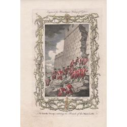
The British Troops entering the Breach of the Moro Castle Engraved for Mountagues History of England.
The scene "CUBA: BATTLE OF HAVANA", British troops entering the breach in the fortress, Morro Castle, during the Battle of Havana, in the July of 1762. Engraved...
Place & Date: London, 1771
Selling price: $60
Sold in 2017
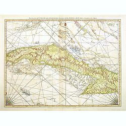
The Island of Cuba with part of the Bahama Banks and the Martyrs. . .
Engraved nautical chart showing tracks, rhumb lines, currents, etc. Relief shown pictorially, depths by soundings. Covers also the southern Florida Keys and Dry Tortugas....
Place & Date: London, Sayer and Bennett, c.1775
Selling price: $520
Sold in 2012
L'Isle de Cuba.
A highly detailed map of Cuba. Also shows a portion of the Bahamas and the Cayman Islands. By Bonne & Raynal in Paris in 1780.Rigobert Bonne (1727-1794) was an influ...
Place & Date: Paris, 1780
Selling price: $22
Sold in 2021
Vue de la prise des forts et ville de havane par les Anglois en 1762.
So-called optical print illustrating a perspective view of the siege of Havana by the English troops in 1762.Mondhare, active at rue St.Jacques a l'Hotel Saumur, was a we...
Place & Date: Paris, c.1780
Selling price: $540
Sold in 2016
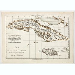
Carte des Isles de Cuba et de la Jamaique.
A hand colored copper engraved antique map of the Caribbean islands of Cuba, Jamaica, the Cayman Islands and part of the Bahama islands. From the Atlas de Toutes les Part...
Place & Date: Paris, 1782
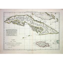
CARTE DES ISLES DE CUBA ET DE LA JAMAIQUE
Very detailed copper-engraved map of Cuba with the southern Bahamas, the Cayman Islands, Jamaica and a small part of Haiti. Many towns are named and some topographical de...
Place & Date: Paris 1782
Selling price: $80
Sold
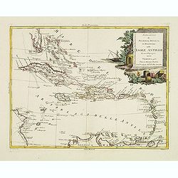
Stabilimenti de Francesi, Inglesi, E Spagnuoli nelle Isole Antille. . .
Uncommon map of Caribbean, including Florida, Bahamas and coast of Venezuela, including Curacao, Artiba I, Buenayre , etc. Engraved by G.Pitteri.
Place & Date: Venice, 1785
Selling price: $200
Sold in 2022
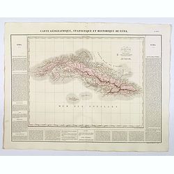
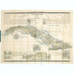
Carte Geographique, Statistique et Historique de Cuba.
A nice detailed map of the island of Cuba, from Buchon's Atlas Gégraphique Statistique, historique et chronologique des deux Ameriques et des isles adjacentes traduit de...
Place & Date: Paris, 1825
Selling price: $60
Sold in 2019

Habana. 2a Vista tomada desde Casa-Blanca.
Decorative view of Havana harbor, by Frederico Mialhe (1810-1881), with his signature on stone lower right. Lithographed by L. Marquier Ce de Lamparillo No. 96. From the ...
Place & Date: Havana, 1838
Selling price: $600
Sold in 2010
Habana. 2a Vista tomada desde Casa-Blanca.
Decorative view of Havana harbor, by Frederico Mialhe (1810-1881), with his signature on stone lower right. Lithographed by L. Marquier Ce de Lamparillo No. 96. From the ...
Place & Date: Havana, 1838
Selling price: $600
Sold in 2010
Habana. 2a Vista tomada desde Casa-Blanca.
Decorative view of Havana harbor, by Frederico Mialhe (1810-1881), with his signature on stone lower right. Lithographed by L. Marquier Ce de Lamparillo No. 96. From the ...
Place & Date: Havana, 1838
Selling price: $500
Sold in 2010
Habana. 2a Vista tomada desde Casa-Blanca.
Decorative view of Havana harbor, by Frederico Mialhe (1810-1881), with his signature on stone lower right. Lithographed by L. Marquier Ce de Lamparillo No. 96. From the ...
Place & Date: Havana, 1838
Selling price: $500
Sold in 2010
Habana. 2a Vista tomada desde Casa-Blanca.
Decorative view of Havana harbor, by Frederico Mialhe (1810-1881), with his signature on stone lower right. Lithographed by L. Marquier Ce de Lamparillo No. 96. From the ...
Place & Date: Havana, 1838
Selling price: $600
Sold in 2010
Habana. 2a Vista tomada desde Casa-Blanca.
Decorative view of Havana harbor, by Frederico Mialhe (1810-1881), with his signature on stone lower right. Lithographed by L. Marquier Ce de Lamparillo No. 96. From the ...
Place & Date: Havana, 1838
Selling price: $700
Sold in 2010
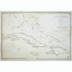
Carte des Grandes Antilles (Cuba, Haïti, Jamaïque, Archipel de Bahama..
Decorative focused on the Greater Antilles. Showing towns, banks, isles and soundings made in meters.Relief shown by hachures. Prepared by M. Keller, hydrographer and en...
Place & Date: Paris, 1843
Selling price: $325
Sold in 2012
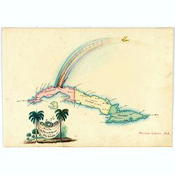
Arribo de Albina Steffanoni a la Isla de CUBA. 1848.
Fine manuscript map of Cuba made on the occasion of the visit of soprano Balbina Steffenone to Cuba in 1848. The map is carefully drawn and heightened by watercolors, orn...
Place & Date: Habana, 1848
Selling price: $500
Sold in 2022

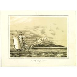
El Zapateado ?
From Album pintoresco de la isla de Cuba - La Havane.
Place & Date: Hamburg and Berlin, c.1850
Selling price: $105
Sold in 2009

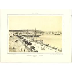
Cercanias de Baracoa ?
From Album pintoresco de la isla de Cuba - La Havane.
Place & Date: Hamburg and Berlin, c.1850
Selling price: $150
Sold in 2009
A view general of the City de Havana of Amerique. / Vue generale de ..
Very decorative and colorful panoramic view over Havana harbour. Engraved for a Vue d'Optique, it was designed to be viewed in a special apparatus that gave the scene a s...
Place & Date: Ca. 1850
Selling price: $100
Sold
Posesiones de America : Isla de Cuba. . .
Wall size map of land areas showing all of Cuba, part of Florida Keys plus San Adios and Salvador Grande in the Bahamas.Minute topographical, political, and hydrographic ...
Place & Date: Madrid, 1853
Selling price: $750
Sold in 2023
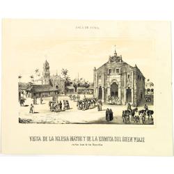
Vista de la iglesia mayor y de la ermita del buenviaje.
Decorative view of the High Church and the Hermitage of Good Voyages at San Juan de los Remedios, by un unknown lithographer after Frederico Mialhe (1810-1881).He is know...
Place & Date: Havana, ca. 1855
Selling price: $500
Sold in 2010
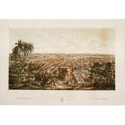
Trinidad Vista general tomada desde la loma de la Vijia.
A splendid, large lithographed view of the city of Trinidad, beautifully and subtly colored. The town is seen from above with in the background the Ocean. People in local...
Place & Date: Havana, Gobierno, 1856
Selling price: $2000
Sold
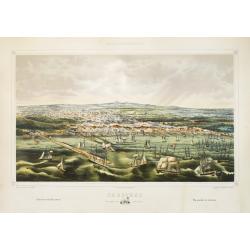
Cardenas Vista general tomada desde la Bahia.
A splendid, large lithographed view of the city of Cardenas, beautifully and subtly colored. The viewer is situated above the sea, looking to the harbour. Dozens of boats...
Place & Date: Havana, Sergio Martin, 1856
Selling price: $2000
Sold
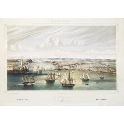
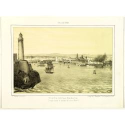
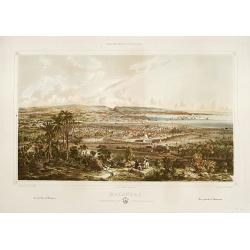
La Habana: vista general tomada desde la entrada del puerto.
A splendid, large lithographed view of the city of Havana as seen from the north, beautifully and subtly colored. The viewer is situated above the sea, looking into the m...
Place & Date: Havana, Sergio Martin, 1856
Selling price: $3000
Sold
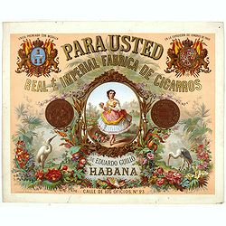
Para usted Real é Imperial frabrica de cigarros de Eduardo Guillo Habana.
Original chromo lithographed advertising poster by Testu & Massin, for the Spanish tobacco company Eduardo Guillo. Printed in Paris by Bognard & Dechavanne and R....
Place & Date: Paris, Bognard & Dechavanne and R. de la Perle, ca. 1870
Selling price: $380
Sold in 2019
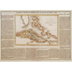
Cuba und die Bahama Inseln.
This is the map of Cuba, includes the Bahama's and southern tip of Florida is from a plano edition of the very scarce German edition of Carey & Lea's "A Complete...
Place & Date: Weimar, 1822-25
Selling price: $190
Sold
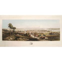
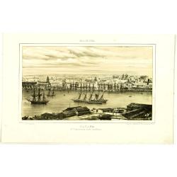
Panorama of Havana.
A fine, large colored steel engraving showing a panoramic view of Havana and its harbour as seen from the south or southeast. The city centre is depicted in remarkable de...
Place & Date: [Havana, G.B. Haase, 1854].
Selling price: $2000
Sold
Matanzas: vista g'ral tomada desde el monte del Cafetal de..
Large colored lithograph from the series ,Isla de Cuba Pintoresca., Matanzas: vista g'ral tomada desde el monte del Cafetal de D. Vicente Guerrero. A large lithographed v...
Place & Date: Havana, Sergio Martin, [1856?].
Selling price: $2000
Sold
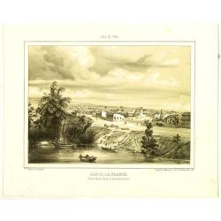
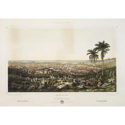
Puerto-Principe: vista g'ral tomada desde El Cristo.
Large colored lithograph from the series ,Isla de Cuba Pintoresca.A splendid, large lithographed view of the city of Puerto-Principe, (now Camag³ey) as seen from the eas...
Place & Date: Havana, Lith. del Gobierno, [1856?].
Selling price: $2000
Sold