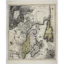
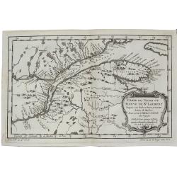
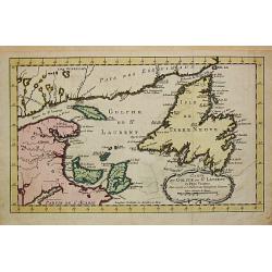
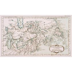
Partie Orientale de la Nouvelle France ou du Canada. . .
A remarkably detailed map of North Eastern Canada, including Nova Scotia, Newfoundland and Labrador. The vertical projection shows the St. Lawrence River running nearly n...
Place & Date: Augsburg, 1756
Selling price: $700
Sold in 2021
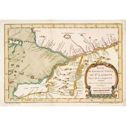
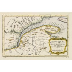
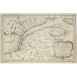
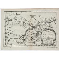
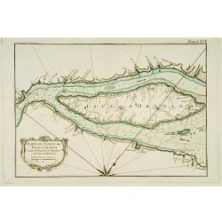
Suite du Cours du Fleuve de St.Laurent depuis Quebec jusqu' au Lac Ontario.
A map of Prevost's 'Hist. des Voyages', depicting the cours of the St. Lawrence river from lake Onario to Quebec.Jaques Nicolaas Bellin (1703-1772) was one of the most im...
Place & Date: Paris, 1757
Selling price: $350
Sold
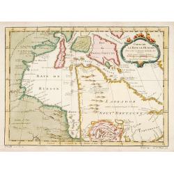
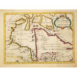
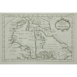
Carte de la Baye de Hudson..
Jacques Nicholas Bellin (1703-1772) was one of the most important and proficient French cartographers of the mid-eighteenth century. He was appointed the first Ingenieur ...
Place & Date: Paris, 1757
Selling price: $240
Sold
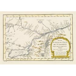
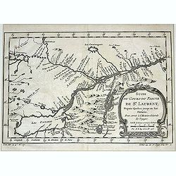
Suite du Cours du Fleuve de St.Laurent..Ontario.
A map of Prevost's 'Hist. des Voyages', depicting the course of the St. Lawrence river from lake Ontario to Quebec.Jacques Nicolas Bellin (1703-1772) was one of the most ...
Place & Date: Paris 1757
Selling price: $100
Sold
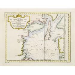
Carte du Cours du Fleuve de St.Laurent..Quebec.
A map of Prevost's 'Hist. des Voyages', depicting the course of the St. Lawrence river from Quebec to the Atlantic.Jacques Nicolas Bellin (1703-1772) was one of the most ...
Place & Date: Paris 1757
Selling price: $180
Sold
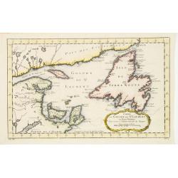
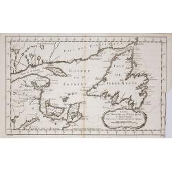
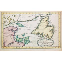
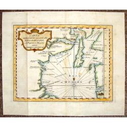
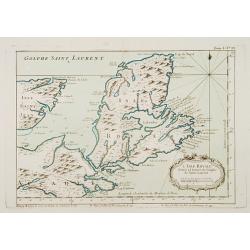
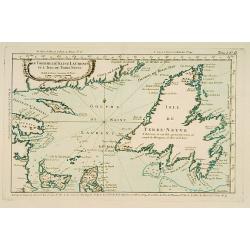
Carte du Golphe de St.Laurent et Pays Voisins..
Accurate map depicting the gulf of St. Lawrence and the surrounding area, included the isle of Newfoundland.Jacques Nicolaas Bellin (1703-1772) was one of the most import...
Place & Date: Paris 1757
Selling price: $80
Sold
Carte Des Parties Du Nord-Ouest De L'Amerique Suivant les Voyages de Middleton et d Ellis..
Very nicely engraved chart that covers most of Hudson's Bay. Locates Fort Prince of Wales and Fort York, the Ottawa Islands (here the Bakers Dozen), the track of Henry El...
Place & Date: Paris 1757
Selling price: $80
Sold
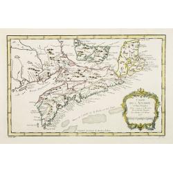
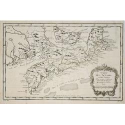
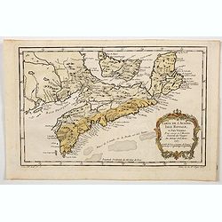
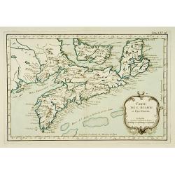
Carte de l' Accadie et Pais Voisins..
First state of this nice map with a decorative rococo-style cartouche. It shows in good detail Prince Edward Island, here called Isle Saint Jean, and covers all of Nova S...
Place & Date: Paris 1757
Selling price: $80
Sold
Carte du Cours du Fleuve de St.Laurent ? Quebec.
A folding map of Prevost's 'Hist. des Voyages', depicting the course of the St. Lawrence river from Quebec to the Atlantic.Jacques Nicolas Bellin (1703-1772) was one of t...
Place & Date: Paris, 1757
Selling price: $80
Sold in 2009
Carte de l' Accadie et Pais Voisins . . .
A nice folding map with a decorative rococo-style cartouche. It shows in good detail Prince Edward Island, here called Isle Saint-Jean, and covers all of Nova Scotia incl...
Place & Date: Paris, 1757
Selling price: $30
Sold in 2011
Carte du Golphe de St.Laurent et Pays Voisins ?
Accurate map depicting the gulf of St. Lawrence and the surrounding area, included the isle of Newfoundland.Jacques Nicolaas Bellin (1703-1772) was one of the most import...
Place & Date: Paris, 1757
Selling price: $70
Sold in 2009
Suite du Cours du Fleuve de St.Laurent depuis Quebec jusqu' au Lac Ontario.
A map of Prevost's 'Hist. des Voyages', depicting the course of the St. Lawrence river from lake Ontario to Quebec.Jacques Nicolaas Bellin (1703-1772) was one of the most...
Place & Date: Paris, 1757
Selling price: $200
Sold in 2013
Carte du Cours du Fleuve de St. Laurent Depuis son Embouchure Jusqu'au Dessus de Quebec.
A detailed regional map of Canada, extending from Anticosti Island to just west of Quebec, centred on the St. Laurence River. From Abbe Prevost's "Histoire Generale...
Place & Date: Paris, 1757
Selling price: $26
Sold in 2021
Suite du Cours du Fleuve de St. Laurent Depuis Quebec Jusqu'a au Lac Ontario.
A detailed map of the region between Lake Ontario and the St. Lawrence River to Quebec. The map extends to Lake Champlain and Lake George, as well as Lake Nepissing with...
Place & Date: Paris, 1757
Selling price: $135
Sold in 2019
Carte de L'Arcade, Isle Royale, et Pais Voisins. . .
Bellin's lovely map of parts of French Canada (The Martimes) during the mid-eighteen century. The map shows Arcadie (Nova Scotia), Isle Royale (Cape Breton), Isle Saint J...
Place & Date: Paris, 1757
![Karte von dem laufe des Flusses St. Laurenz von seiner Mündung an bis über Quebec. . .1757. [together with] Fernerer Lauf des Flusses St. Laurentz. . .](/uploads/cache/39140-250x250.jpg)
Karte von dem laufe des Flusses St. Laurenz von seiner Mündung an bis über Quebec. . .1757. [together with] Fernerer Lauf des Flusses St. Laurentz. . .
Two maps of the entrance of the St. Laurence river up beyond Quebec. With a second map from Quebec to Lake Ontario.From a German edition of the ' Histoire. des Voyages'. ...
Place & Date: Augsburg, 1758
Selling price: $75
Sold in 2018
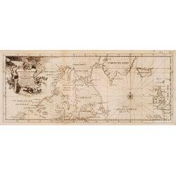
Eine neue karte von den Gegenden 1746 und 1747 eine Nord-Westliche Durchfahrt..
Uncommon map of Hudson, Great Lakes and northern Atlantic, showing the tracks of Captain Heinrich Ellis from London to the Hudson.
Place & Date: Germany 1760
Selling price: $260
Sold
Carte du Golphe de St. Laurent et Pays Voisins.
Jaques Nicolas Bellin (1702-720) was the most important French hydrographer of the 18th century. Sea-atlas 'Hydrographique Français' , 1756-65, atlas to accompany Prévo...
Place & Date: Paris, c. 1760
Selling price: $100
Sold
Carte de la Baye de Hudson.
Jaques Nicolas Bellin (1702-720) was the most important French hydrographer of the 18th century. Sea-atlas 'Hydrographique Français' , 1756-65, atlas to accompany Prévo...
Place & Date: Paris, c. 1760
Selling price: $90
Sold in 2019
Carte du Golphe de St. Laurent et Pays Voisins.
Jaques Nicolas Bellin (1702-720) was the most important French hydrographer of the 18th century. Sea-atlas 'Hydrographique Français' , 1756-65, atlas to accompany Prévo...
Place & Date: Paris, c. 1760
Selling price: $135
Sold in 2008
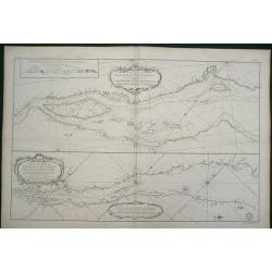
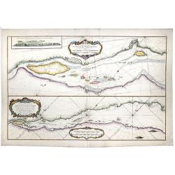
Partie du Cours du Fleuve de Saint Laurent... Carte du Cours du Fleuve de Saint Laurent depuis Quebec jus
Two charts horizontally oriented with tremendous detail of the rivers and shoreline. Decorated with three rococo-style cartouches and rhumb lines.Good margins sheet size ...
Place & Date: Paris, 1761
Selling price: $500
Sold in 2014
Partie du Cours du Fleuve de Saint Laurent... / Carte du Cours du Fleuve de Saint Laurent depuis Quebec jus.
A map of the banks of the St. Lawrence river from Quebec to the Atlantic in 2 sheets.[The other sheet also present in this auction !]Two charts horizontally oriented wit...
Place & Date: Paris, 1761
Selling price: $600
Sold in 2020
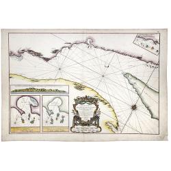
Carte du Cours du Fleuve de Saint Laurent. Depuisla Mer jusqu'a Quebec en Deux feuilles . . .
A map of the banks of the St. Lawrence river from Quebec to the Atlantic in 2 sheets. [1 of 2] Two insets with maps entitled "Baye des Sept Isles" and "Les...
Place & Date: Paris, 1761
Selling price: $85
Sold in 2020
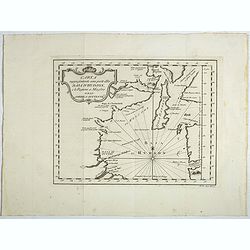
Baye de Hudson et Pays Voisins.
This chart shows the territories of Hudson Bay.The only issue of this version of Bellin's map, slightly larger than the common version. Depths shown by soundings.From Bel...
Place & Date: Paris, 1763
Selling price: $60
Sold in 2011
Carta Rappresente Una Parte dlla Baja D'Hudson.
Fine copperplate engraved map of the northern portion of Hudson's Bay in Canada. It is from Masi's "Il Gazzettiere Americano". There is a decorative cartouche.
Place & Date: Livorno, 1763
Selling price: $35
Sold in 2015
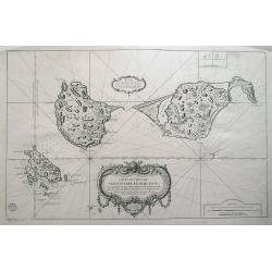
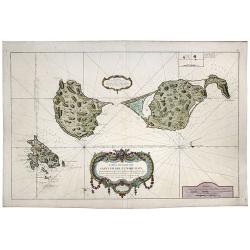
Carte des isles de St Pierre et de Miquelon...
Large scale sea-chart of the French overseas terrirtory Saint Pierre and Miquelon near Newfoundland.Very detailed with topographical information of the islands, also show...
Place & Date: Paris, 1763
Selling price: $140
Sold in 2014
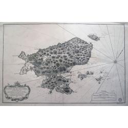
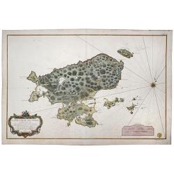
Plan de l´Ile de Saint Pierre au Sud de Terre-Neuve...
Large sea chart of Saint-Pierre. Highly detailed showing small islands, reefs, depth soundings, exact topographical details. Decorated with a large title cartouche and a ...
Place & Date: Paris, 1763
Selling price: $175
Sold in 2014
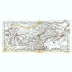
Canada.
Uncommon miniature map of Eastern Canada, engraved by Thomas Kitching for "A New General and Universal Atlas Containing Forty five Maps by Andrew Dury".This min...
Place & Date: London, 1761-1763
Selling price: $100
Sold in 2018
Carta rappresentante una parte dlla Baja D'Hudson e le Regioni a Maestro Dell'America Settentrle.
A fine map the northwest corner of Hudson Bay from Masi's "Il Gazzettiere Americano." Published by Gio. Tommaso Masi.
Place & Date: Livorno, 1763
Selling price: $30
Sold in 2018
Carte des Isles de Saint Pierre et Miquelon. . .
A large scale sea-chart of the French overseas territory Saint Pierre and Miquelon near Newfoundland. A very detailed chart with topographical information of the islands,...
Place & Date: Paris, 1763
Selling price: $200
Sold in 2020
Saint Pierre, Plan de l'Ile de .., au Sud de Terre-Neuve.
A highly detailed map based on a survey by Fortin, and published by the 'Dépôt Général de la Marine' (the maritime chart printing office of the French government) in ...
Place & Date: Paris, 1763
Selling price: $200
Sold in 2022
La Nouvelle France où Canada.
This chart shows the territories of New-France and Canada the day before the signature of the treaty of Paris.The only issue of this version of Bellin's map, slightly lar...
Place & Date: Paris 1764
Selling price: $350
Sold
L'Isle Royale située à l'entrée du Golphe de Saint Laurent.
This chart shows the territories of Nova Scotia.The only issue of this version of Bellin's map, slightly larger than the common version. Depths shown by soundings.From Be...
Place & Date: Paris 1764
Selling price: $100
Sold
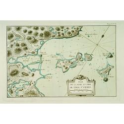
Plan de la Rade et Port de l'Isle Saint-Pierre.
This chart shows a detailed part of the east coast of the island Saint Pierre and Miquelon, which is now-a-day's still French territory.The only issue of this version of ...
Place & Date: Paris 1764
Selling price: $52
Sold
Carte de l'Acadie et Pays Voisins.
Fine chart shows in good detail Prince Edward Island, here called Isle Saint Jean, and covers all of Nova Scotia including Cape Breton. Locates numerous banks south of No...
Place & Date: Paris 1764
Selling price: $100
Sold
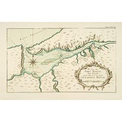
Plan du Port Royal dans l\'Acadie, Appelé Aujourd\' par les Anglois Annapolis Royal.
This chart shows the territories of Port Royal in Acadia.The only issue of this version of Bellin\'s map, slightly larger than the common version. Depths shown by soundin...
Place & Date: Paris 1764
Selling price: $50
Sold
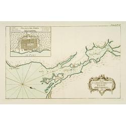
Plan de la Baye de Chibouctou nommée par les Anglois Halifax.
This chart shows the territories of Halifax in Nova Scotia, with an inset of the town.The only issue of this version of Bellin's map, slightly larger than the common vers...
Place & Date: Paris 1764
Selling price: $100
Sold
Partie du Fleuve de Saint -Laurent avec le Bassin de Québec et l'Isle d'Orléans.
This chart shows the island of Orleans in the river Saint Laurent .The only issue of this version of Bellin's map, slightly larger than the common version. Depths shown b...
Place & Date: Paris 1764
Selling price: $102
Sold
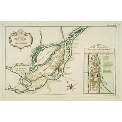
L'Isle de Montréal et ses Environs.
This chart shows the territories of the island Montreal, with an inset plan of the town with a lettered key.The only issue of this version of Bellin's map, slightly large...
Place & Date: Paris 1764
Selling price: $175
Sold
Le Golphe de Saint-Laurent et l'Isle de Terre-Neuve.
This chart shows the territories the Saint Laurent and the island of Newfoundland.The only issue of this version of Bellin's map, slightly larger than the common version....
Place & Date: Paris 1764
Selling price: $92
Sold