Browse Listings in Africa > Southern Africa
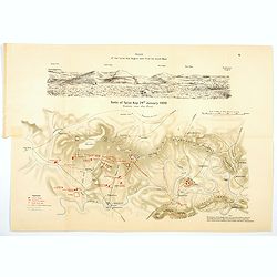
Battle of Spion Kop. 24th January, 1900 Situation soon after 10 a.m.
[Map no.6] The Battle of Spion Kop was fought about 38 km (24 mi) west-south-west of Ladysmith on the hilltop of Spioenkop, along the Tugela River, Natal in South Africa ...
Place & Date: Edinburgh / London, 1900
Selling price: $17
Sold in 2021
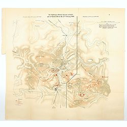
The Fighting at Monte Cristo on the 18th, and at Wynne's Hill on the 22nd February, 1900.
[Map no.8] Map is divided into two, the situation at 6pm on the 22nf Feb (Wynne's Hill) & the situation at *am on the 18th Feb (Monte Cristo). Concerning the fighting...
Place & Date: Edinburgh / London, 1900
Selling price: $12
Sold in 2021
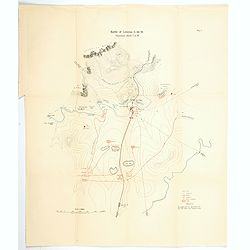
Battle of Colenso, 15th December 1899, Situation about 7 a.m.
[Map no.6] The battle of Colenso was the third and final battle fought during the Black Week of the Second Boer War. It was fought between British and Boer forces from th...
Place & Date: Edinburgh, London, ca 1900
Selling price: $14
Sold in 2021
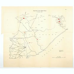
Disposition of the British Forces in January 1900.390
[Map no.2] A large folding map showing British forces in South Africa as of January 1900, covering vast distances in the Cape Colony and The Orange Free State. A sketch m...
Place & Date: Edinburgh, London, ca 1900
Selling price: $13
Sold in 2021
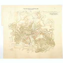
Fight north of Colenso on the 27th February, 1900. Situation about 5pm.
[Map no.9] On 27th February 1900, the pontoon bridge was moved to a position further east along the river and the British launched an attack across the Tugela on the hill...
Place & Date: Edinburgh, London, ca 1900
Selling price: $17
Sold in 2021
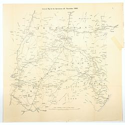
General Map for the Operations till November, 1900
[Map no.1] A large folding map showing the field of all British operations up until November 1900. It stretches from Kimberley (OFS) in the SW to Lyndenburg in the NW (Tr...
Place & Date: Edinburgh, London, ca 1900
Selling price: $13
Sold in 2021
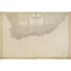
South Africa - Cape of Good Hope and adjacent coasts from Hondeklip Bay to Port Natal. Chart 2176.
Large chart representing the Cape of Good Hope and the surrounding area. A couple of places on the coastline are highlighted in red and yellow.Title flanked by explicativ...
Place & Date: London, 1867 updated for 1903
Selling price: $190
Sold in 2018
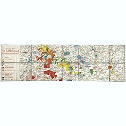
Sketch Map of the Far Eastern Rand from Johannesburg to Ermelo.
An extremely rare map showing mining concessions on the Eastern Part of the Witwatersrand Vein, the most important gold region in the world, published shortly after the S...
Place & Date: Bern, Geographischer Karten-Verlag Kümmerly & Frey, ca. 1905
Selling price: $500
Sold in 2017
![[Africa - General continental map with Ottoman script]](/uploads/cache/44736-250x250.jpg)
[Africa - General continental map with Ottoman script]
Post card size map in Ottoman script showing Southern Africa from Mehmet Eşref’s ‘Küçük Atlas’, a rare portfolio of loose-leaf maps with text in Ottoman Turkis...
Place & Date: Istanbul, Şirket-i Mürettibiye ve Karacoğlu Matbaası 1325 or 1909
Selling price: $150
Sold in 2022
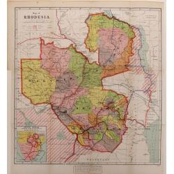
Map of Rhodesia.
A color-printed, wood engraved map of Rhodesia (now Zimbabwe), as administered by the British South Africa Company, which lasted from 1889 to 1924, when it became a Briti...
Place & Date: London, 1923
Selling price: $70
Sold in 2016
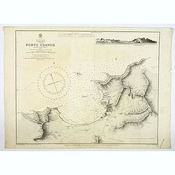
Cape Verde Islands, St. Vincent, Porto Grande. . .
A large maritime chart of Porto Grand on the island of St. Vincent of the Cape Verde islands. The map has tremendous physical detail, plus the settlement of Mindello. The...
Place & Date: London, [1874] 1926
Selling price: $205
Sold in 2019
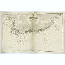
Cape of Good Hope & Adjacent Coasts from Hondeklip Bay to Port Natal.
A very large double sheet British Admiralty sea chart of the Cape of Good Hope in South Africa. It has extensive coastal detail, with lighthouses or beacons, highlighted ...
Place & Date: London, [1867] 1927
Selling price: $300
Sold in 2019
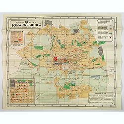
Tourist Plan of Johannesburg.
A lovely color map in brochure form of Johannesburg, with a pair of inset plans one is 'HOW TO FIND The Johannesburg Publicity Association Offices and Visitors Bureau' &a...
Place & Date: Pretoria, 1936
Selling price: $100
Sold in 2020
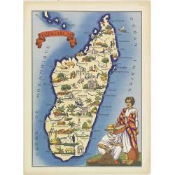
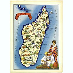
Madagascar
Very decorative, informative map of Madagascar. The map is filled with buildings, animals, figures and two locals in their typical dress.In lower left corner "Imprim...
Place & Date: France, 1943
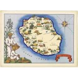
La Réunion.
Very decorative, informative map of the island of Reunion. The map is filled with buildings, animals, figures and two locals. With a large compass rose in upper right cor...
Place & Date: France, 1943
Selling price: $70
Sold
La Réunion.
Very decorative, informative map of the island of Reunion. The map is filled with buildings, animals, figures and two locals. With a large compass rose in upper right cor...
Place & Date: France, 1943
Selling price: $60
Sold in 2016
Madagascar
Very decorative, informative map of Madagascar. The map is filled with buildings, animals, figures and two locals in their typical dress.In lower left corner "Imprim...
Place & Date: France, 1943
Selling price: $60
Sold in 2016
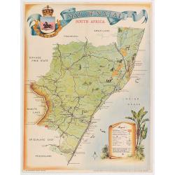
Map of Natal.
Pictorial map of Natal showing the rail way system, published by the Government printer. Decorated with tourist attractions and key in lower right.Read more about Pictori...
Place & Date: Pretoria, 1949
Selling price: $70
Sold in 2020
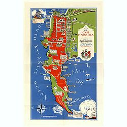
A Map of the Cape Peninsula. Issued by the Cape Peninsula Publicity Association Adderley Street Cape Town South Africa.
Beautiful pictorial map of the Cape Peninsula South Africa shows, its neighbourhood's, green spaces, and historic points of interest. Drawn by Stuart Boyle and published ...
Place & Date: Cape Town, 1952
Selling price: $325
Sold in 2018
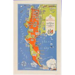
A Map of the Cape Peninsula. Issued by the Cape Peninsula Publicity Association Adderley Street Cape Town South Africa.
Beautiful pictorial map of the Cape Peninsula South Africa shows, its neighborhood's, green spaces, and historic points of interest. Drawn by Stuart Boyle and published b...
Place & Date: Cape Town, 1952
Selling price: $80
Sold in 2020
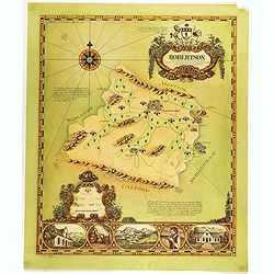
A map of Robertson area as defined for the production of wines of origins . . .
Decorative map of Robertson, a wine area in South Africa. The Cape winelands stretch from the rugged mountains and multi-directional slopes of the coastal region to the o...
Place & Date: South Africa, 1973
Selling price: $60
Sold in 2019
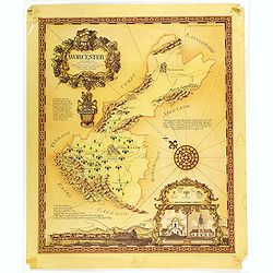
A map of the Worcester area as defined for the production of wines of origin . . .
Decorative map of Worcester, a wine area in South Africa. The Cape winelands stretch from the rugged mountains and multi-directional slopes of the coastal region to the o...
Place & Date: South Africa, 1973
Selling price: $85
Sold in 2019
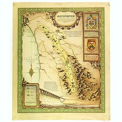
A map of the Olifantsrivier area as defined for the production of wines of origin . . .
Decorative map of Olifantsrivier, a wine area in South Africa. The Cape winelands stretch from the rugged mountains and multi-directional slopes of the coastal region to ...
Place & Date: South Africa, 1973
Selling price: $100
Sold in 2019
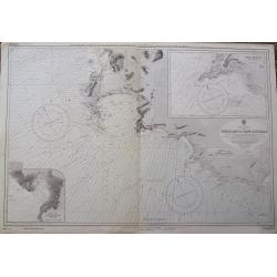
Table Bay to Cape Agulhas.
A large scale Admiralty sea-chart of Cape Town, extending until Struis Bay. With excellent detail of the coasts, including depth soundings. With two insets of Point Dange...
Place & Date: London, 1973
Selling price: $50
Sold in 2018
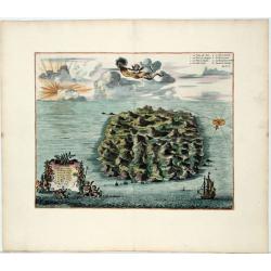
Saint Helena.
This fine hand colored original copper-plate engraved antique map of the Island of St Helena in the southern Atlantic that was published by Pieter Van der Aa. With cherub...
Place & Date: Leiden, ca 1710
Selling price: $130
Sold in 2020