Browse Listings in Africa > North Africa > North Africa
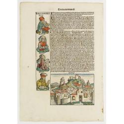
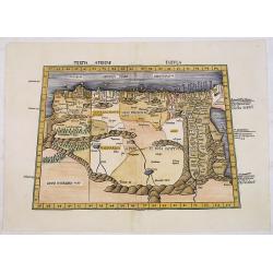
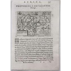
Tercia Etas Mundi. / Carthago. / Folio XL.
A very fine presentation of the city of Carthage, centered on the church.(Dim. H : 120 mm W : 168 mm). Ancient Carthage was the Phoenician city-state of Carthage. During ...
Place & Date: Nuremberg, 12 July 1493
Selling price: $200
Sold in 2020
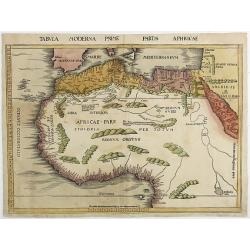
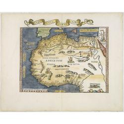
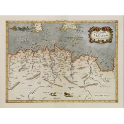
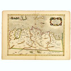
Tabula Moderna Prime partis aphricae.
From Martin Waldseemüller's edition of Ptolemy's Geography , often considered to be the first modern atlas. This is the first printed modern map of North and West Africa...
Place & Date: Strassburg, 1513
Selling price: $5100
Sold in 2011

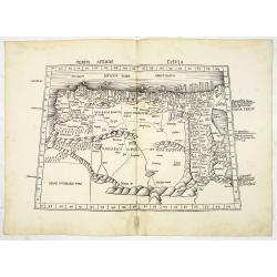
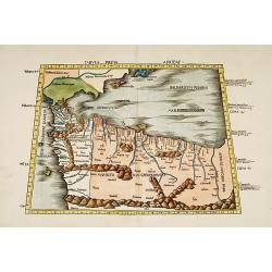
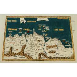
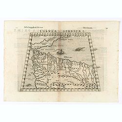
Tertia Africae Tabula.
Early woodcut map of North Africa from M. Waldseemuller of 1513 (1520). Showing the region from Bengazi in Libya up to Egypt with the Red Sea.This ptolemaic map comes fro...
Place & Date: Strasbourg, 1513
Selling price: $2100
Sold in 2011
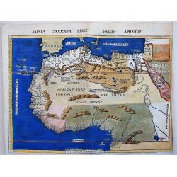
Tertia Africae Tabula (North Africa)
Wood block printed large-format Ptolemaic map showing Northeastern Africa, extending from Egypt and the Red Sea (Sinus Arabicus) to Libya. Showing an interesting Nile sys...
Place & Date: Strasburg, 1513
Selling price: $2400
Sold
Tabula Moderna Prime partis aphricae.
This maps belongs to the famous 1513, Martin Waldseemüller's, edition of Ptolemy's Geography, which is often considered to be the first modern printed atlas. It is very ...
Place & Date: Strassburg, 1513
Selling price: $2350
Sold in 2017
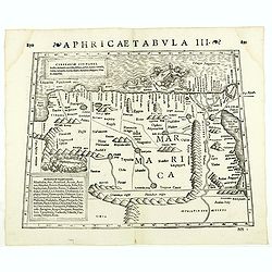
Tabula prima Africae.
One of the earliest maps of Morocco and the northern coast of Africa, including the Balearic islands.From the 1513 Strasburg edition of Ptolemy's Geographia , generally c...
Place & Date: Strasbourg, 1513-1520
Selling price: $1600
Sold
Tertia Africae Tabula.
Early woodcut map of North Africa from M. Waldseemüller of 1513 (1520). Showing the region from Bengazi in Libya up to Egypt with the Red Sea.From Waldseemüller's Ptole...
Place & Date: Strasbourg, Johannes Schott, 1513-1520
Selling price: $1250
Sold in 2016
![TABULA II MODERNA APHRICE.[Malta]](/uploads/cache/82606-250x250.jpg)
TABULA II MODERNA APHRICE.[Malta]
A rare 1525 edition of Lorenz Fries's woodcut map of the central part of the North African coastline, with islands in the Mediterranean, based upon the work of Waldseemul...
Place & Date: Strasbourg, 1525
Selling price: $270
Sold in 2019
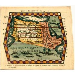
![LIBYAE INTERIORI PARS. [Egypt & Libya]](/uploads/cache/82607-250x250.jpg)
LIBYAE INTERIORI PARS. [Egypt & Libya]
A rare 1525 edition of Lorenz Fries's woodcut map of the central part of the North African coastline, with islands in the Mediterranean, based upon the work of Waldseemul...
Place & Date: Strasbourg, 1525
Selling price: $300
Sold in 2019
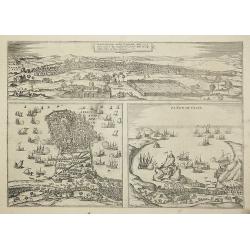
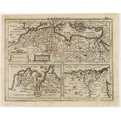
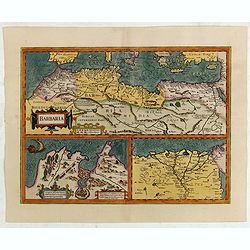
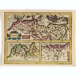
Tunes Oppidum Barbarie & Regina fedes ... / Africa olim Aphrodisum. / Penon de Veles.
Three town-views on one sheet: Tunis, Mahdia and Penon de Veles.The Civitates was compiled and written by George Braun, Canon of Cologne Cathedral. Braun gathered togethe...
Place & Date: Cologne, 1535
Selling price: $200
Sold in 2011
Tabu nova partis Aphri. (North Africa)
Based on Waldseemuller's map. Border and ornament are by Hans Holbein and Graf. The maps show Northern Africa as it was known to Europeans at the first part of the 16th c...
Place & Date: Lyons, M. Servetus, 1535
Selling price: $2000
Sold in 2011
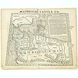
Tabula I Aphricae.
Trapezoidal Ptolemaic woodcut map by Laurent Fries features the northwest corner of Africa, which is often referred to as the Maghreb (meaning western in Arabic), and inc...
Place & Date: Vienna, 1522- 1535
Selling price: $375
Sold in 2019
![[North Africa with Egypt] Tabula III. Aphricae. Hae Sunt E Cognitis Totius Orbis . . . (title on verso)](/uploads/cache/42943-250x250.jpg)
[North Africa with Egypt] Tabula III. Aphricae. Hae Sunt E Cognitis Totius Orbis . . . (title on verso)
One of the earliest obtainable maps of North Africa, with Egypt, from Lorenz Fries' (1490-1532) edition of Ptolemy's Geographia, largely based on the 1513 map by Waldseem...
Place & Date: Vienna, 1522, 1535
Selling price: $425
Sold in 2019
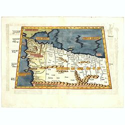
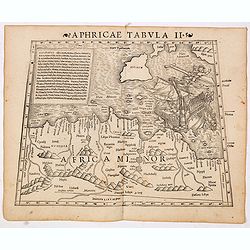
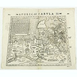
Aphricae tabula secunda continet.
Map representing northern Africa.The fourth edition of Ptolemy's Geographia utilising Lorenz Fries's woodcut maps was published in Vienne, Dauphine, in 1541 by Gaspar Tre...
Place & Date: Vienna, 1541
Selling price: $300
Sold
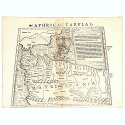
Aphricae Tabula I (Mauritania - present-day Morocco, Algeria, and Tunisia.)
The first edition of Munster's map of Mauritania - present-day Morocco, Algeria, and Tunisia, based upon Claudius Ptolemy which appeared in his "Geographia Universal...
Place & Date: Basel, Heinrich Petri, 1545
Selling price: $200
Sold in 2019
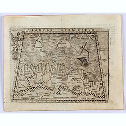
Aphricae Tabula II (Northern Africa and the Mediterranean showing parts of Sicily, Tunisia and Libya.)
The first edition of Munster's map of Northern Africa and the Mediterranean showing parts of Sicily, Tunisia and Libya, based upon Claudius Ptolemy which appeared in his ...
Place & Date: Basel, Heinrich Petri, 1545
Selling price: $300
Sold in 2014
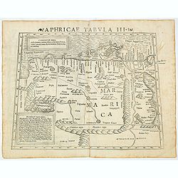
Aphricae Tabula III (Northern Africa and the Mediterranean, including Egypt.)
The first edition of Munster's map of Northern Africa and the Mediterranean, including Egypt, based upon Claudius Ptolemy which appeared in his "Geographia Universal...
Place & Date: Basel, Heinrich Petri, 1545
Selling price: $200
Sold in 2020
Aphricae Tabula I (Mauritania - present-day Morocco, Algeria, and Tunisia.)
The first edition of Münster's map of Mauritania - present-day Morocco, Algeria, and Tunisia, based upon Claudius Ptolemy which appeared in his "Geographia Universa...
Place & Date: Basel, Heinrich Petri, 1545
Selling price: $100
Sold in 2018
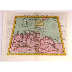
Tabula Aphricae II.
Gastaldi's map of North Africa and part of the Mediterranean, including Malta, Sardinia and Sicily. Embellished with two mythical birds and a ship wreck off the coast. Ba...
Place & Date: Venice, 1548
Selling price: $300
Sold in 2022
Sinus Arabicus (North Africa)
Woodcut from P. Mela's "De Orbis Situ Libri tres". Published by Henric Perti. Almost a decade after the death of Sebastian Münster, his publisher and stepson H...
Place & Date: Basle, 1561
Selling price: $130
Sold in 2021
Tabula Aphricae II
Fine Ptolemaic style map of North Africa and including Sardinia, Sicily and the southern tip of Italy. It was published in 1562.
Place & Date: Venice, 1562
Selling price: $105
Sold in 2017
Tabula Aphricae I.
Early map of north-west Africa. Girolamo Ruscelli first published the map in his "La Geographi di Claudio Tolomeo" (Venice, 1561). In 1574 a new plate was used ...
Place & Date: Venice, 1564
Selling price: $60
Sold in 2020
Aphricae Tabula III. (North Africa and Egypt)
Double-page woodcut Ptolemaic-style map by Sebastian Münster figuring North Africa and Egypt., published in the edition of Strabo by Henri Petri in 1571."Strabonis ...
Place & Date: Basle, Henri Petri, 1571
Selling price: $60
Sold in 2018
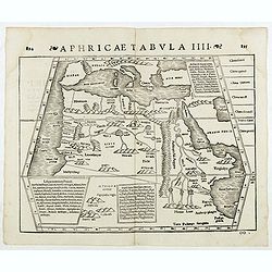
Aphricae Tabula IIII. (North Africa and the Mediterranean)
Double-page woodcut Ptolemaic-style map by Sebastian Münster figuring North Africa and the Mediterranean, published in the edition of Strabo by Henri Petri in 1571."...
Place & Date: Basle, Henri Petri, 1571
Selling price: $200
Sold
Aphricae Tabula II. (Northern Africa and the Mediterranean showing parts of Sicily, Tunisia and Libya)
Double-page woodcut Ptolemaic-style map by Sebastian Münster figuring Northern Africa and the Mediterranean showing parts of Sicily, Tunisia and Libya, published in the ...
Place & Date: Basle, Henri Petri, 1571
Selling price: $105
Sold in 2018
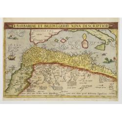
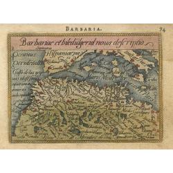
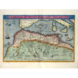
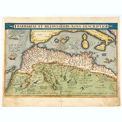
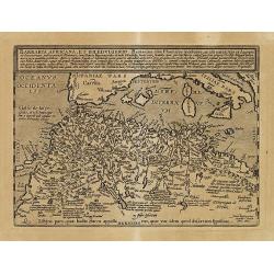
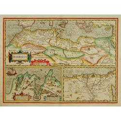
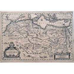
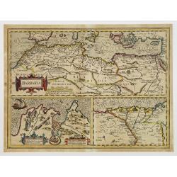
Barbariae et Biledulgerid, nova descriptio.
North-West Africa. Koeman speculated: ''In view of the important trading relationship between Antwerp and Africa, it is not impossible that the original was a manuscript ...
Place & Date: Antwerp 1572
Selling price: $300
Sold
![[Algiers].](/uploads/cache/14175-250x250.jpg)
[Algiers].
On recto an early representation of Algiers (142x185 mm). On verso a representation of a sword and a corona.From a French text edition of his Cosmographia , that great co...
Place & Date: Basle, after 1575
Selling price: $20
Sold in 2012
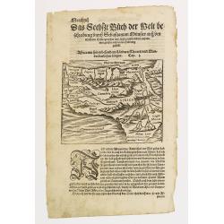
Affrica mit seinem befondern Landern Theiren und Wunderbarlichen Dingen.
Strong dark impression of Münster's small map of Africa, from a German edition of the "Cosmographia".One of the earliest obtainable maps of the African contine...
Place & Date: Basle, 1579
Selling price: $70
Sold in 2010
Barbariae et Biledulgerid, nova descriptio.
North-West Africa. Koeman speculated: In view of the important trading relationship between Antwerp and Africa, it is not impossible that the original was a manuscript ma...
Place & Date: Antwerp, 1579
Selling price: $220
Sold in 2017
Tab.II AFRICAE, Complectens AFRICAM Proprie dictam..
Ptolemeac map, shows the western part of the mediterranean with North-african coast, and parts of Sardinia and Sicily.The Island of Malta and Gozo right in the centre.
Place & Date: Antwerp after 1580
Selling price: $250
Sold
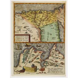
Aegypti recentior descriptio./ Carthaginis..
Two maps on one sheet. Upper part of the sheet (180x230mm) map of the northern part of Egypt with the Nile Delta. Lower part map of the north east corner of Africa with T...
Place & Date: Antwerp, 1580
Selling price: $60
Sold in 2010
![[Lot with 12 maps of the Mediterraneans and Egypt.] Aegypti Recenttior Carthageni / General Karte des Roemischen Reichs](/uploads/cache/83963-250x250.jpg)
[Lot with 12 maps of the Mediterraneans and Egypt.] Aegypti Recenttior Carthageni / General Karte des Roemischen Reichs
A map of the Middle East and the Mediterranean. Taken from 'Algemeine Welthistorie (der Neuern Zeiten)', edited by S.J. Baumgarten, J.S.Semler a.o. Abraham Ortelius...
Place & Date: Antwerp, c. 1580
Selling price: $198
Sold in 2022
Africae Tabula Quarta. . .
The most general of the four Ptolemaic maps of Africa from Mercator’s definitive edition of Ptolemy’s geography. It extends far enough south to fully show Ptolemy’s...
Place & Date: Cologne, ca 1584
Selling price: $360
Sold in 2019
Barbariae et Biledulgerid, nova descriptio.
North-West Africa. Koeman speculated: In view of the important trading relationship between Antwerp and Africa, it is not impossible that the original was a manuscript ma...
Place & Date: Antwerp 1587
Selling price: $190
Sold
Barbariae et biledulgerid nova descriptio
Miniature map of the Barbary coast and parts of Italy and Spain. The map is beautifully engraved with stippled seas.
Place & Date: Antwerp, 1588
Selling price: $65
Sold
![Nova Africa hoc est,recens eius inuestigatio. [North Africa]](/uploads/cache/32529-250x250.jpg)
Nova Africa hoc est,recens eius inuestigatio. [North Africa]
On verso an early map of North West Africa (123x155mm.), with on recto a small map of the island of Madeira (120x78mm.) From a Latin text edition of his Geographia , that...
Place & Date: Basle, 1550-1590
Selling price: $85
Sold in 2013
![[De Africae regionibus / Carthage]](/uploads/cache/32593-250x250.jpg)
[De Africae regionibus / Carthage]
On the verso an early birds-eye view of Tunis, which was the original city of Carthage (240x168mm.). The plan includes zoological and botanical gardens, castle Goleta, a ...
Place & Date: Basle, 1550-1590
Selling price: $20
Sold in 2013
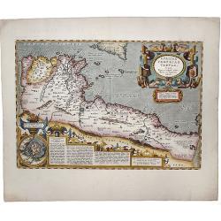
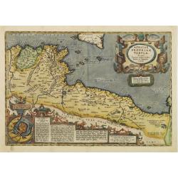
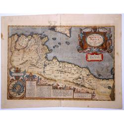
Africae propriae tabula. In qua, Punica regna uides; Tyrios, et Agenoris urbem.
The most beautiful early map of the northern coast of Africa available to the collector. Prepared by Ortelius himself. A very fine example. Ortelius based this map on tha...
Place & Date: Antwerp,1590
Selling price: $360
Sold in 2020
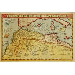
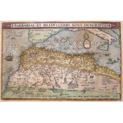
Barbariae Et Biledvlgerid, Nova Descriptio.
Attractive map of Africa by Abraham Ortelius. The map covers the area on the north-west coast of Africa from about present day Senegal and "Fume del Oro"...
Place & Date: Antwerp, (1570) 1592
Selling price: $325
Sold in 2011
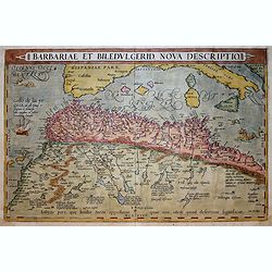
Barbariae Et Biledvlgerid...
Remarkable map of Northern Africa in an early shape. Extends from Morocco and the Sahara to Libya and large parts of the Mediterranean, including the Balearic Islands, Si...
Place & Date: Antwerp, 1592
Selling price: $230
Sold in 2016
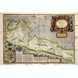
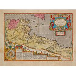
Africae propriae Tabula..
The most beautiful early map of the northern coast of Africa that is available to the collector. Prepared by Ortelius himself based on modern information from Gastaldi's ...
Place & Date: Antwerp 1595
Selling price: $165
Sold
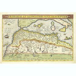
Barbariae et Biledulgerid, nova descriptio.
North-West Africa. Koeman speculated: In view of the important trading relationship between Antwerp and Africa, it is not impossible that the original was a manuscript ma...
Place & Date: Amsterdam, 1596
Selling price: $800
Sold

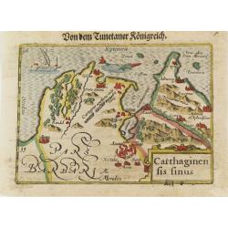
Carthaginensis sinus.
Very fine early miniature map showing Tunis and its surroundings. The sea is embellished with a ship and a sea monster. The map depicts the ancient site of Carthage with ...
Place & Date: Middelburg, 1598
Selling price: $40
Sold in 2014
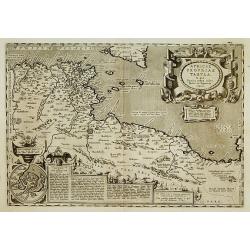
Provincia Cartaginese. Tunigi.
An attractive small map of the environs of Tunis in Northern Africa. It is from the "Relationi Universale" by Botero, published in Venice in 1598. Woodcut in pa...
Place & Date: Venice, 1598
Selling price: $21
Sold in 2017
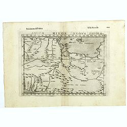
Africa minor nuova tavola.
The third state of Ruscelli's map of North Africa, based upon Claudius Ptolemy. Showing the region of present day Algiers, Tunisia and Libya. Girolamo Ruscelli first publ...
Place & Date: Venice, 1598
Selling price: $50
Sold in 2018
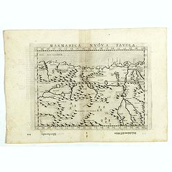
Marmarica nuova tavola.
The third state of Ruscelli's map of northern Africa based upon Claudius Ptolemy. Showing the Nubia Desert and showing Egypt, the Nile, etc. Girolamo Ruscelli first publi...
Place & Date: Venice, 1598
Selling price: $50
Sold in 2018
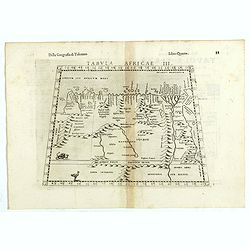
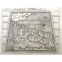
Tabula Africae III.
The third state of Ruscelli's map of North Africa and the Mediterranean, based upon Claudius Ptolemy. Showing the north coast of Africa including Egypt and the Nile River...
Place & Date: Venice, 1598
Selling price: $50
Sold in 2018
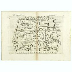
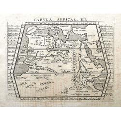
Tabula Africae IIII.
The third state of Ruscelli's map of The Northern part of Africa, based upon Claudius Ptolemy. Showing Mediterranean, Aethiopia Interior, the Canary Islands, Asia Minor, ...
Place & Date: Venice, 1598
Selling price: $95
Sold in 2018
Barbariae et Biledulgerid, nova descriptio.
North-West Africa. Koeman speculated: In view of the important trading relationship between Antwerp and Africa, it is not impossible that the original was a manuscript ma...
Place & Date: Antwerp, 1598
Selling price: $325
Sold in 2021
Africae propriae Tabula..
The most beautiful early map of the northern coast of Africa available to the collector. Prepared by Ortelius himself. Ortelius based the map on Gastaldi.
Place & Date: Antwerp 1603
Selling price: $350
Sold
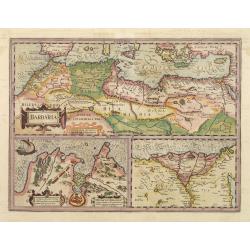
Barbaria Africana, et Biledulgerid. . .
Uncommon map showing the south of Spain, and the northwest of Africa, with Morocco, Algeria, Tunisia. With the Canary Islands in the outer left.
Place & Date: Cologne, Bussemacher, 1603
Selling price: $70
Sold in 2011
Africae propriae Tabula..
The most beautiful early map of the northern coast of Africa available to the collector. Prepared by Ortelius himself. Ortelius based the map on Gastaldi.
Place & Date: Antwerp, 1603
Selling price: $275
Sold in 2018
Barbaria/ Egypt/ Tunesia.
Upper map showing the Northern African coast, including Cyprus, Greece and Sicily. Lower part maps of Tunis and Nile Delta.
Place & Date: Amsterdam, 1606
Selling price: $300
Sold
Barbaria.
Upper map showing the Northern African coast, including Cyprus, Greece and Sicily. Lower part maps of Tunis and Nile Delta.From the first French-text edition of Jodocus H...
Place & Date: Amsterdam, 1608
Selling price: $100
Sold in 2011
AFRICAE PROPRIAE TABULA. In qua, Punica regna uides; Tyrios, et Agenoris urbem.
The most beautiful early map of the northern coast of Africa available to the collector. Prepared by Ortelius himself. This fine example is from the rare Italian edition ...
Place & Date: Antwerp, 1608
Selling price: $280
Sold in 2021
AFRICAE / PROPRIAE / TABULA / In qua, / Punica regna vides. / Tyrios, et Agenoris / urbem. / 1590.
A very decorative map of Northern Africa. Abraham Ortelius(1527-98), Dutch cartographer and publisher of the first modern atlas, ' Theatrum Orbis Terrarum' in 1570. Editi...
Place & Date: Antwerp, Robert Bruneau, 1609
Selling price: $260
Sold in 2021
Carthaginensis Sinus.
Early miniature map of Tunisian northern coast. Title cartouche on the lower right corner. First published in 1598 in his Caert-Thresoor, the plates were executed by the ...
Place & Date: Amsterdam/Frankfurt 1609
Selling price: $50
Sold in 2008
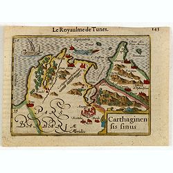
Carthaginen fis Finus.
This is a map of the Barbary area, subtitled "Le royaulme des Tunes".
Place & Date: Amsterdam, 1612
Selling price: $50
Sold in 2015
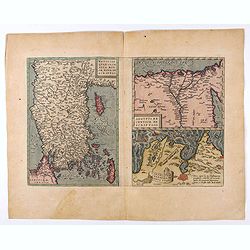
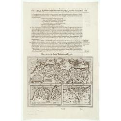
Natoliae. . .Aegypti recentior..Carthaginis (3 maps on 1 sheet).
Rare. Three maps on one sheet. Map to the left east to the top. Detailed map Turkey, including Cyprus and Crete. Also map of the Nile delta and another map of Tunis.
Place & Date: Antwerp, 1608-1612
Selling price: $95
Sold in 2020
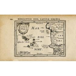
Insulae Capitis Viridis
Attractive map of the Cape Verde islands and the Moroccan coast. Very detailed naming many cities, islands, and major rivers. Decorative map from a Hondius/Bertius pocket...
Place & Date: Amsterdam c. 1616
Selling price: $80
Sold in 2009
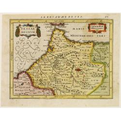
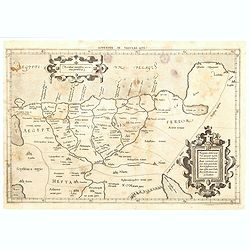
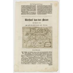
Fessae regnum.
Nice small map of the northeast tip of Africa with Fez showing as the principal city. Decorative title and distance scale cartouches. French text on verso.
Place & Date: Amsterdam 1617
Selling price: $20
Sold
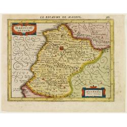
Marocchi Regnum.
A nice map of a part of Morocco with the city Marrakech.
Place & Date: Amsterdam 1617
Selling price: $25
Sold
Tabula Aphricae I.
A fine Ptolemaic map, probably from the Jansson/Magini atlas of 1617. It shows parts of today's Morocco and Algeria. Includes also a part of southern Spain and the Balear...
Place & Date: Amsterdam, 1617
Selling price: $30
Sold in 2018
Tabula Africae IIII.
A fine Ptolemaic map, probably from the Jansson/Magini atlas of 1617. It shows southern Europe, northern Africa, including Arabia in an early representation with curious ...
Place & Date: Amsterdam, 1617
Selling price: $65
Sold in 2018
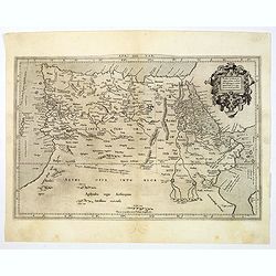
Appendix Tab. III. Africae, Aegyptum Inferiorem Exhibens.
Map of the Nile delta based on the Ptolemaic model. Mercator originally published this map in his 1578 edition of Ptolemy's great Geography. Although he is most renowned ...
Place & Date: Amsterdam, 1618
Selling price: $40
Sold in 2020
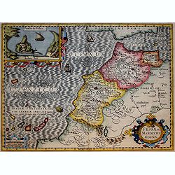
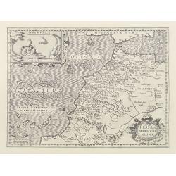
Fessae et Marocchi Regna
Richly embellished map of Morocco with a large inset titled Penon de Velez showing a fort on the Barbary coast. The map includes the Canary islands and Madera.Three strap...
Place & Date: Amsterdam, 1619
Selling price: $315
Sold in 2017
Barbaria.
Small map illustrating the eastern part of the Mediterranean Basin, namely the African side. Surrounded by text in Dutch.Included in the rare book : Wereld Spiegel, waer ...
Place & Date: Amsterdam, Cloppenburch, 1621
Selling price: $95
Sold in 2013
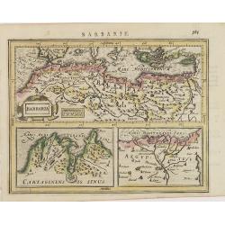
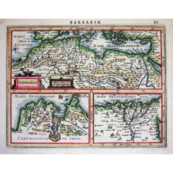
BARBARIA.
With two insets: Map of the Siege of Tunis and map of the Nile Delta.From the tenth edition of the Mercator's Atlas Sive Cosmographicae completed and reissued by Henricus...
Place & Date: Amsterdam 1628
Selling price: $200
Sold
Barbaria.
Excellent map by Jansson, engraved for Mercators Atlas Minor (page 575). The map is divided in three parts: the top part is showing Northern Africa with the Mediterranean...
Place & Date: Amsterdam, c.1628
Selling price: $70
Sold
Barbaria. / Carthaginensis sinus / Aegyptus.
With two insets: Map of the Siege of Tunis and map of the Nile Delta.From the tenth edition of the Mercator's Atlas Sive Cosmographicae completed and reissued by Henricus...
Place & Date: Amsterdam, ca.1628
Selling price: $60
Sold in 2015
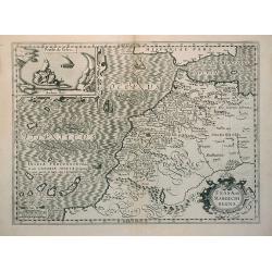
Fessae et Marocchi Regna
Richly embellished map of Morocco with a large inset titled Penon de Velez showing a fort on the Barbary coast. The map includes the Canary islands and Madera.Three strap...
Place & Date: Amsterdam, 1630
Selling price: $130
Sold
Fessae et Marocchi Regna.
Richly embellished map of Morocco with a large inset titled Penon de Velez showing a fort on the Barbary coast. The map includes the Canary islands and Madera.Three strap...
Place & Date: Amsterdam, 1630
Selling price: $260
Sold in 2010
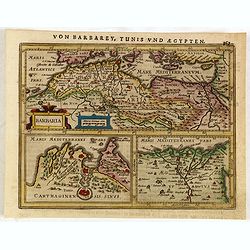
Barbaria
Three maps on one sheet. In upper half a map of North Africa with the Mediterranean and Cyprus. In lower part maps of the region around Tunis and map of the Nile Delta.Fr...
Place & Date: Amsterdam, c. 1630
Selling price: $20
Sold in 2011
Barbaria.
Charming map of the whole of North Africa and the famed Barbary coast. Two large insets at bottom: Carthaginensis Sinus with the city of Tunis, and a map of the Nile Delt...
Place & Date: Amsterdam, 1630
Selling price: $45
Sold in 2015
Tab.II AFRICAE, Complectens AFRICAM Proprie dictam..
Decorative Ptolemaic map of Northern Africa with the southern part of Sardinia and Sicily and Malta. The sea is stipple engraved and contains two very fanciful sea monste...
Place & Date: Amsterdam, 1630
Selling price: $50
Sold in 2015
Nova Barbariae Descriptio
Fantastic and highly decorative map of North Africa covers from Morocco to the Nile delta, and large parts of the Mediterranean from Portugal to Cyprus. Africa is filled ...
Place & Date: Amsterdam, ca. 1638
Selling price: $160
Sold in 2016
Barbaria./ Egypt/ Tunesia.
Three maps on one sheet. Upper part, it shows the coast of Barbaria from Morocco to Egypt: the map on the left corner of Tunis includes a plan of Goletiae, and the right ...
Place & Date: Amsterdam, 1641
Selling price: $50
Sold in 2015
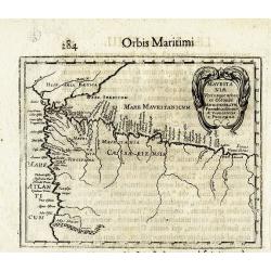
MAURITANIAE
Rare early map of north-west Africa, showing Algeria and Morocco, and parts of Spain. Only places on the coast, and a few rivers are named. Embellished with a large decor...
Place & Date: Dijon, 1643
Selling price: $100
Sold in 2013
BARBARIA.
Charming map of the whole of North Africa and the famed Barbary coast. Two large insets at bottom, Carthaginensis Sinus with the city of Tunis, and a map of the Nile Delt...
Place & Date: Amsterdam 1639-1644
Selling price: $77
Sold
Barbaria / Egypt / Tunesia.
Samuel Purchas' edition of the Mercator/Hondius "Atlas Minor". Northern Africa published in his famous collection of voyages "His Pilgrimes". With des...
Place & Date: London 1645
Selling price: $80
Sold