Browse Listings in Africa > North Africa > Algeria
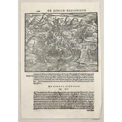
De Africae Regionibus.
A very early Münster wood cut view of Algiers, showing its attempted storming during the Algiers Expedition.Sebastian Münster (1488-1552), was a famous German cartograp...
Place & Date: Basel, 1558
Selling price: $20
Sold in 2018
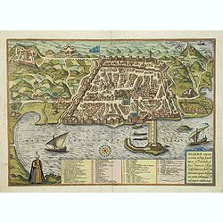
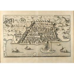
ALGERII Sarace norum urbis fortissimae.
An attractive town-plan of the Alger, including a numbered key legend in the lower part. From the greatest publication in this genre!. The "Civitates" was compi...
Place & Date: Cologne, 1580
Selling price: $500
Sold in 2017
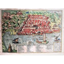
ALGERII Sarace norum urbis fortissimae.
Attractive, old colored town-plan of the city of Alger, including a numbered key legend in the lower part. From the greatest publication in this genre!. The "Civitat...
Place & Date: Cologne, 1580
Selling price: $401
Sold in 2019
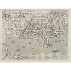
Algeri.
Rare view of the city of Algiers, with its fortifications, harbor and adjacent area by M.Florimi. With key a-Z, 1-48 of the principal buildings.Florimi\'s works are among...
Place & Date: Siena, ca. 1580
Selling price: $1550
Sold in 2008
![[De Africae regionibus ] Algier.](/uploads/cache/32594-250x250.jpg)
[De Africae regionibus ] Algier.
On verso an early birds-eye town-plan of Alger.From a Latin text edition of his Geographia , that great compendium of Renaissance knowledge.
Place & Date: Basle, 1550-1590
Selling price: $55
Sold in 2013
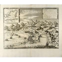
Abbildung der Statt Gigeri in affrica, wie solche der König in Franckreich durch den Hertzogen de Beaufort eingenohmen
Attractive engraving of the Jijel (Djidjelli) in North-west Algeria from Matthaus Merian. Showing the city with several ships and the Atlas Mountains in background. With ...
Place & Date: Frankfurt, 1646
Selling price: $200
Sold in 2009
Algier
Attractive birdeye view of Algiers in Algeria from Matthäus Merian. Showing the city with city walls, outlying forts and several ships in the harbour. From J. Gottfried'...
Place & Date: Frankfurt, 1646
Selling price: $110
Sold in 2009
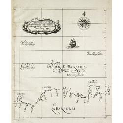
Carta particolare del mare Mediterraneo che comincia con il capo Bogia è Finisce con il porto de tre Croce.
Robert Dudley (1574-1649). English geographer. His rare atlas 'Arcano del Mare' was the first English sea-atlas, the first with charts -all in Mercator-projection- of the...
Place & Date: Florence, 1661
Selling price: $225
Sold in 2009
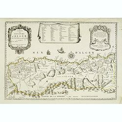
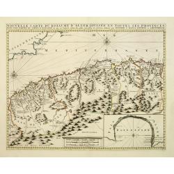
Carte du Royaume d'Alger . . .
Uncommon map of the Algerian coast, with fine title and scale cartouches in the top.
Place & Date: Paris, 1665
Selling price: $450
Sold
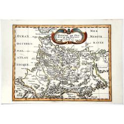
ROYAUME DE FEZ divise en Sept Provinces.
A striking map of Morocco and part of present-day Algeria in Northern Africa. Mountain ranges, forests and notable buildings have been included. Title in an ornate cartou...
Place & Date: Paris 1683
Selling price: $45
Sold in 2019
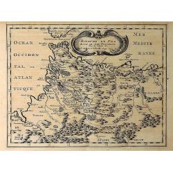
Royaume de Fez Divise en Sept Provinces. . .
A striking map of Morocco and part of present-day Algeria in Northern Africa. Mountain ranges, forests and notable buildings have been included. Title in an ornate cartou...
Place & Date: Paris, 1683
Selling price: $12
Sold in 2021
Algiers.
Magnificent bird's eye- of Algiers. Etched by Gaspar Bouttats (1640-1695).The Antwerp based publisher Jacques Peeters published ca. 1690 a series of prints related to the...
Place & Date: Antwerp, c.1690
Selling price: $150
Sold in 2013
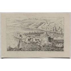
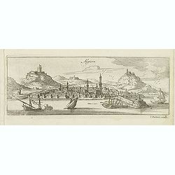
Port d'Alger.
A fine copper engraved city view of Algiers, in Algeria from about 1700.
Place & Date: Paris, ca 1700
Selling price: $75
Sold in 2020
Nouvelle carte du Roiaume D\'Alger divisée en toutes ses provinces, avec une partie due cotes D\'Espagne . . .
Rare and detailed map of the coast of Algeria. Large inset map of the Bay of Alger (El-Jazir). Shows a coastline of Spain around Alicante. Two compass roses in the Medite...
Place & Date: Amsterdam, 1720
Selling price: $145
Sold in 2012
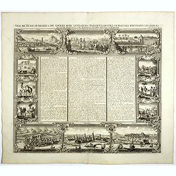
Vue de Tunis D Alger &c de Gigeri avec Quelques Particularitez Curieuses . . .
The plate is bordered by series of views with views and people of present-day Algeria. On top a view of Algiers, a funeral and how they executed criminals. On the bottom ...
Place & Date: Amsterdam, 1728
Selling price: $45
Sold in 2017
Algercum ?
One of Seutter's most decorative prospects, with a sea battle in the foreground.
Place & Date: Augsburg, c.1730
Selling price: $430
Sold in 2010
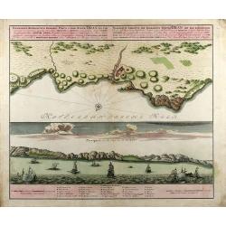
View and map of Oran in Algeria
Full titles on top in Latin and German: 'Topographica Repraesentatio Barbarici Portus et Urbis Munitae Oran ... / Wahrhafte Abbildung ... Oran ...', with impressum: 'Homa...
Place & Date: Nuremberg, 1732
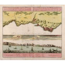
Topographica Repraesentatio Barbarici Portus et Urbis Munitae Oran / Wahrhaffte Abbildung der Barbarischen Vestung Oran
Original old colored copper engraved map from Chr. Gephart by Homann Heirs published 1732 in Nuremberg. Showing the coast outline of Algeria (province Oran) on the upper ...
Place & Date: Nuremberg, 1732
Selling price: $160
Sold in 2013
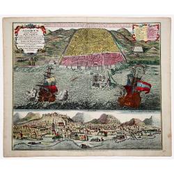
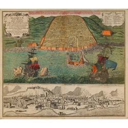
ALGERUM munita Metropolis REGNI ALGERIANI in littore Africano Barbariae in monte delici Amphitheatri instar quadrata forma... SEDES EST BASSAE TURCICI... (ALGIERS)
An impressive, originally colored sheet with two views of the town of Alger. A bird-eye view of the town and its harbor with two large galleons and a panoramic view, from...
Place & Date: Ausburg 1732
Selling price: $420
Sold in 2021
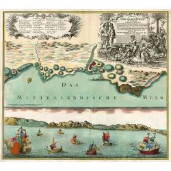
Wahrhaffte Abbildung der Barbarischen Vestung Oran
Hand colored copper engraving from Chr. Gephart by Homann Heirs, showing coast outline of Algeria (province Oran) and some sailing ships.
Place & Date: Nuremberg, 1732
Selling price: $250
Sold in 2008
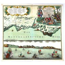
Oran Munita Urbs et Comodus Porta in Ora Maritima Barbariae.
Map of the vicinity of Oran with panoramic view from the sea below.
Place & Date: Augsburg, 1740
Selling price: $300
Sold in 2010
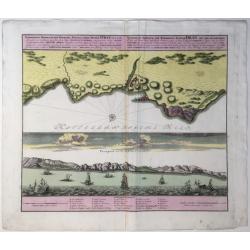
Oran Munita Urbs et Comodus Port in Ora Maritima.
A beautiful map depicting the plan, and the panorama, of the coast of Oran, Algeria with many boats in the foreground. In opulent original period colors. The legend is in...
Place & Date: Augsburg, 1740
Selling price: $300
Sold in 2016
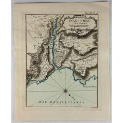
Plan D'Oran et Ses Environs.
A fine nautical chart of the fortified city of Oran in Algeria. It was published in LE PETIT ATLAS MARITIME. It features a decorative cartouche. Jacques Bellin (1703 – ...
Place & Date: Paris, 1764
Selling price: $19
Sold in 2018
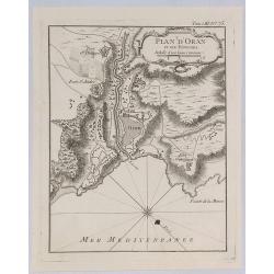
Plan d'Oran et Ses Environs.
A fine nautical chart of the fortified city of Oran in Algeria. It was published in “LE PETIT ATLAS MARITIME”. It features a decorative cartouche. Jacques Bellin (170...
Place & Date: Paris, 1764
Selling price: $17
Sold in 2019
![[73] Barbarie. Oran..](/uploads/cache/12845-250x250.jpg)
[73] Barbarie. Oran..
"Charming chart of the harbour of the town of Oran in Algeria. Showing town and harbour plan, with soundings, anchorages, rocks, shoals, fortifications and lighthous...
Place & Date: Marseille 1764
Selling price: $60
Sold in 2014
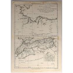
Etats du Roi de Maroc. Les Royaumes D'Algier, de Tunis et de Tripoli, avec les Pays Circonvoisins.
A North African map of Algeria, Tunisia, and Tripoli by Raynal and Bonne in 1780. It is from Atlas of All Known Parts of Globe, Lists For Philosophical History and Polic...
Place & Date: Paris, 1780
Selling price: $15
Sold in 2018
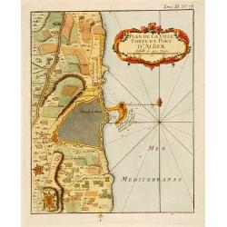
Plan de la Ville Fort et Port d'Alger.
This plan of Algiers, published originally in Bellin's Petit Atlas Maritime and was later issued in vol.III of the Abbé Prévost's "Histoire g&a...
Place & Date: Paris c.1780
Selling price: $30
Sold
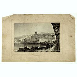
Alger, vue générale prise du port.
Decorative lithography taken from "Voyage pittoresque dans la régence d'Alger" printed in 1835 by Charles Motte. Prepared by WYLD William Wyld (1806-1889) and ...
Place & Date: Paris, 1835
Selling price: $25
Sold in 2016
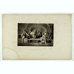
Alger, Café Maure rue du Soudan.
Decorative lithography taken from "Voyage pittoresque dans la régence d'Alger" printed in 1835 by Charles Motte. Prepared by WYLD William Wyld (1806-1889) and ...
Place & Date: Paris, 1835
Selling price: $25
Sold in 2021
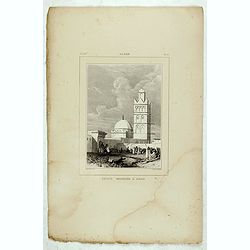
Alger, Petite mosquée à Oran.
Decorative lithography taken from "Voyage pittoresque dans la régence d'Alger" printed in 1835 by Charles Motte. Prepared by WYLD William Wyld (1806-1889) and ...
Place & Date: Paris, 1835
Selling price: $25
Sold in 2021
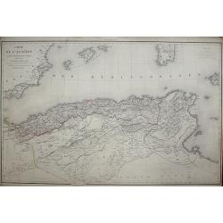
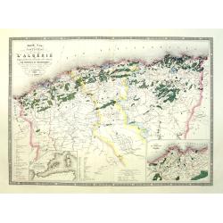
Carte de l'Algérie, dressée Au Dépôt Général de La Guerre sous la direction de M. le Lieut.t Général Pelet
Place & Date: Paris, 1846
Selling price: $200
Sold in 2008
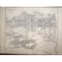
Carte de la Province de Constantine, dressée Au Dépôt Général de La Guerre sous la direction de M. le Lieutenant Général Pelet
Place & Date: Paris, 1847
Selling price: $165
Sold in 2008
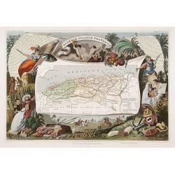
Algerie Colonie Française.
A very decorative 19th century map of Algeria. The map is surrounded by horses, products of the country, natives, etc.
Place & Date: Paris 1850
Selling price: $170
Sold
Algérie d'après les cartes de L'état-major et les documents du Ministère de la Guerre
A map of Algeria.
Place & Date: Paris, 1860
Selling price: $125
Sold in 2008
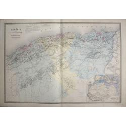
Afrique Francaise. Algerie.
Very detailed map from Atlas Sphérodoïdal & Universel de géographie , Prepared by F.A.Garnier and edited by Jules Renouard, rue de Tournon, Paris. Uncommon map wit...
Place & Date: Paris 1861
Selling price: $35
Sold
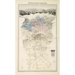
Province ou dèpt de Constantine.
Decorative map of one of the provinces in Algeria from "Géographie Universelle, Atlas Migeon." published by J. Migeon. Very nice engraving of the view of Const...
Place & Date: Paris, 1874
Selling price: $35
Sold in 2017
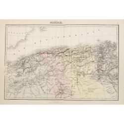
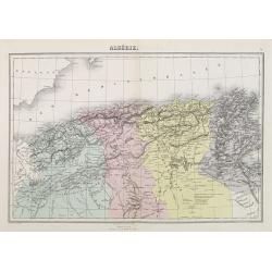
Algérie
Decorative map of Algeria from Géographie Universelle, Atlas Migeon. published by J. Migeon. From one of the last decorative atlases published in the 19th century.
Place & Date: Paris 1874
Selling price: $40
Sold
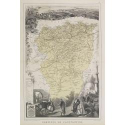
Province de Constantine.
Decorative map of the Constantine Province in north-eastern Algeria from Géographie Universelle, Atlas Migeon. With Constantine's coat of arms lower left corner. Publish...
Place & Date: Paris, 1874
Selling price: $40
Sold in 2020
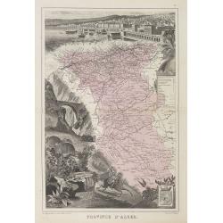
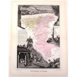
Province d'Alger.
Decorative map of the Alger province in Algeria from Géographie Universelle, Atlas Migeon. The map is surrounded by an engraving representing the town of Alger and a lan...
Place & Date: Paris, 1874
Selling price: $50
Sold in 2012
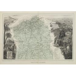
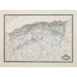
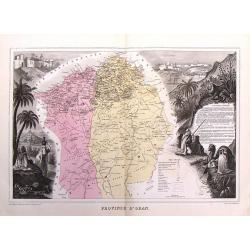
Province d'Oran.
Decorative map of the Oran province in Algeria from Géographie Universelle, Atlas Migeon. With two engravings left and right of the map representing the towns and landsc...
Place & Date: Paris, 1874
Selling price: $100
Sold
Algérie.
A decorative map of Algeria from Géographie Universelle, Atlas Migeon, published by J. Migeon.< br />From one of the last decorative atlases published in the 19th ...
Place & Date: Paris, 1874
Selling price: $40
Sold
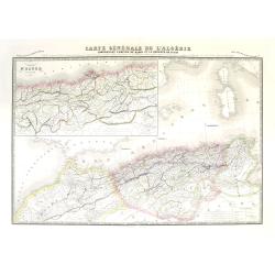
Carte générale de l'Algérie comprenant l'empire de Maroc et la régence de Tunis. Dresée d'après les derniers documents publiés par les Dépots de la Marine. . .
Very large, highly detailed and uncommon map of Algeria together with Morocco and Tunisia, with inset map "Environs d'Alger Divisés par tribus" (the surroundin...
Place & Date: Paris, 1875
Selling price: $240
Sold
Nouvelle carte forestière de l'Algérie indiquant la division territoriale civile et militaire par provinces et départements.
Very large, highly detailed and uncommon map of Algeria, with 2 inset maps "Carte du territoire d'Alger" and "Carte du Bassin occidental de la Méditerran�...
Place & Date: Paris, 1876
Selling price: $120
Sold
Province D'Alger.
Fine map of the province of Alger, Algeria by Migeon from his atlas "GEOGRAPHIE UNIVERSELLE" published in Paris in 1878.
Place & Date: Paris, 1878
Selling price: $25
Sold in 2016
Province d'Oran.
This is a fine copy of Migeon's 1878 map of the province of Oran, Algeria. it is decorated by scenes from the region and came from "GEOGRAPHIE UNIVERSELLE" one ...
Place & Date: Paris, 1878
Selling price: $26
Sold in 2016
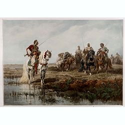
Arab horsemen.
Adolf Schreyer (July 9, 1828 Frankfurt-am-Main – July 29, 1899 Kronberg im Taunus) was a German painter, associated with the Düsseldorf school of painting. His subject...
Place & Date: Cologne, ca. 1890
Selling price: $220
Sold in 2019
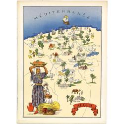
Alger.
Very decorative, informative map of Algeria. The map is filled with buildings, animals, figures and two locals in their typical dress.In lower left corner "Imprimé ...
Place & Date: France, 1943
Selling price: $90
Sold in 2018
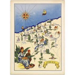
Oran. (Algeria)
Very decorative, informative map of Oran province in Algeria. The map is filled with buildings, animals, ships, figures and two locals in their typical dress.In lower lef...
Place & Date: France, 1943
Selling price: $70
Sold