Browse Listings in Africa > Central Africa > West coast / Ivory coast
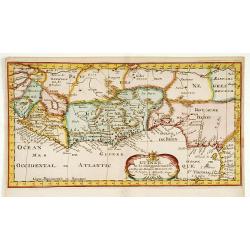
![[West Africa]](/uploads/cache/34461-250x250.jpg)
[West Africa]
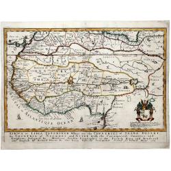
Rare first edition. West Africa, from the Tropic of Cancer south to St Thomas. The interior is filled with lions, elephants, monkeys and camels, with a fenced native vill...
Place & Date: Venice, 1556
Selling price: $472
Sold in 2014

Arzilla Maxima Quodam Africe Urbs. . .
A city view of Asilah by Braun & Hogeburg. TRANSLATION OF CAPTION: Asilah, formerly the largest city in Africa, is today confined within the narrowest bounds by the C...
Place & Date: Antwerp, 1575
Selling price: $80
Sold in 2020
Vera effigies et delineatio Insulae Ascenscio nuncupatae sitae in altitudine 8 graduum ad austrum lineae aequinoctialis.
This is Linschoten's map of Ascension Island in the south Atlantic, beautifully engraved by Baptista a Doetechum.Decorative print showing three coastal views of Ascension...
Place & Date: Amsterdam, c.1596
Selling price: $375
Sold in 2012
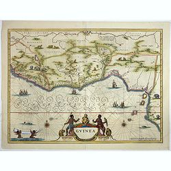
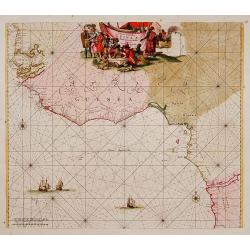
Affbeeldinghe der custen des landts Guinea, Manicongo..
A superbly decorative early engraved by Arnold Van Langren. The ocean is filled with superbly engraved compass spurs, Dutch galleons and elaborate strapwork cartouches. ...
Place & Date: Amsterdam, 1598
Selling price: $3700
Sold in 2008
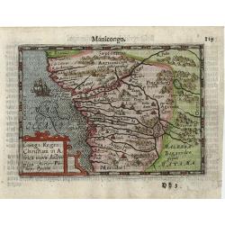
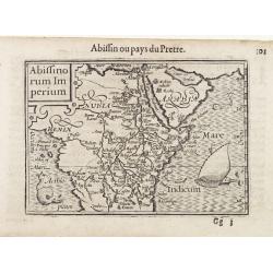
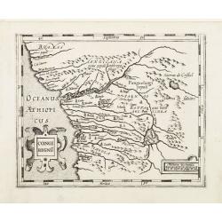
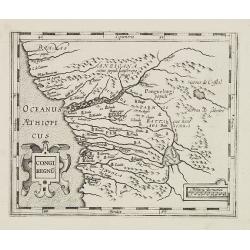
Congi Regni Christiani in Africa.
A fine early miniature map of the West coast of Africa, this map is from the first edition of the Langenes atlas (later well known under the name of Bertius). Dutch text ...
Place & Date: Middelburg, 1598
Selling price: $55
Sold in 2014
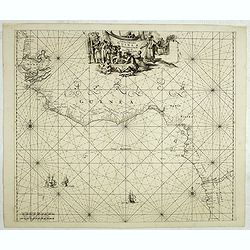
Affbeeldinghe der custen des landts Guinea, Manicongo. . .
A superbly decorative early chart engraved by Arnold van Langren. The ocean is filled with superbly engraved compass spurs, Dutch galleons and elaborate strapwork cartouc...
Place & Date: Amsterdam, 1598
Selling price: $4200
Sold in 2011
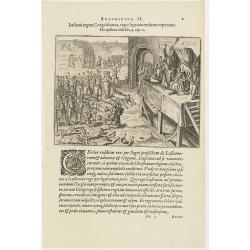
Argumentum II. Lufitani regem Congi falutant, eique legationem fuam exponunt. De quibus Vide lib. 2 cap 2.
The Portuguese appear before the king of the Congo. When the king of the Congo heard about his neighbor, the prince of Sogno, being converted to Christianity, he called t...
Place & Date: Frankfurt, 1598
Selling price: $60
Sold in 2019
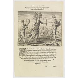
Argumentum V. Armatura tam nobiliorum quam gregariorum militum descripta lib. 1. cap. 7. (How the Congolese dress for war and play)
The distinguished inhabitants of the Congo decorate their head-dresses with ostrich, peacock or other feathers and, wound cross-wise across their bare chests they have ch...
Place & Date: Frankfurt, 1598
Selling price: $90
Sold in 2016
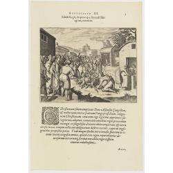
Edicti Regii, de quo cap. 3 fecundi libri agitur, executio. (How the king of the Congo had all the devilish idols burnt )
How the king of the Congo had all the devilish idols burnt. After the king of the Congo adopted the Christian religion, he told all his noblemen and servants to hand over...
Place & Date: Frankfurt, 1598-1599
Selling price: $45
Sold in 2017
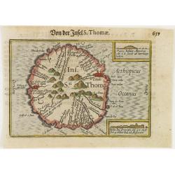
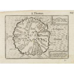
Ins. Sti. Thome
Early miniature map of Saint Thomas from the Caert-Thresoor and engraved by the Dutch master-engraver Petrus Kaerius. The first edition was printed in Middelburg by Baren...
Place & Date: Amsterdam, 1600
Selling price: $40
Sold in 2008
Congi Regni Chriffiani in Africa
Based on the geographical data of Philippo Pigafetta
Place & Date: Amsterdam, c. 1602
Selling price: $110
Sold
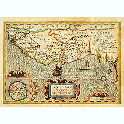
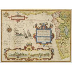
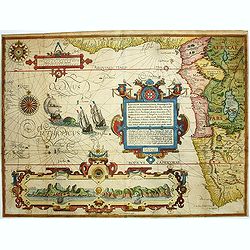
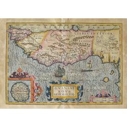
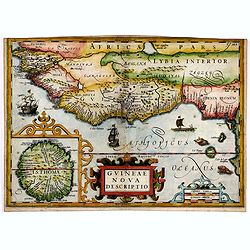
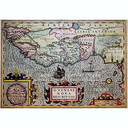
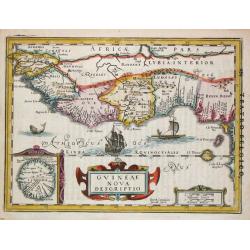
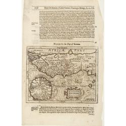
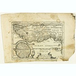
GUINEAE Nova Descriptio.
"The map shows the west coast from Senegal (Rio Senego) to Cape Lopez, just below the equator, and includes Guinea, with a portion of the Benin kingdom and of Lybia....
Place & Date: Amsterdam, 1606
Selling price: $360
Sold
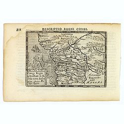
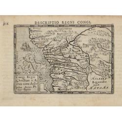
Descriptio Regni Congi.
An attractive miniature map of the Christian Kingdom of Congo in western Africa, published by Petrus Bertius, in Amsterdam at the beginning of the seventeenth century. It...
Place & Date: Amsterdam, 1606
Selling price: $50
Sold in 2021
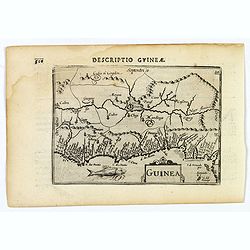
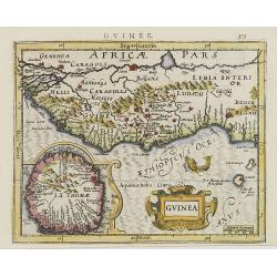
Guinea.
A fine miniature map of the west African region of Guinea, published by Petrus Bertius in Amsterdam early in the seventeenth century. The map and has a strap-work title, ...
Place & Date: Amsterdam, 1606
Selling price: $50
Sold in 2019
Guinea.
This Hondius' map of Guinea is probably the most attractive map of this area. An inset with a elaborate strap work border depicts the island of S. Thomas.From the first F...
Place & Date: Amsterdam, 1608
Selling price: $230
Sold in 2010
Insula & Arx Mosambique.
Very fine early miniature map of Africa. Title cartouche on the upper left corner : surrounding the continent, three sea monsters and a ship are depicted. The map shows a...
Place & Date: Amsterdam/Frankfurt, 1609
Selling price: $185
Sold in 2008
Ins. Sti. Thome.
Early miniature map of island of São Tomé.First published in 1598 in his Caert-Thresoor, the plates were executed by the most famous engravers in Amsterdam, including P...
Place & Date: Amsterdam/Frankfurt, 1609
Selling price: $150
Sold in 2009
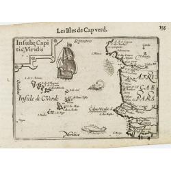
Insulae Capitis Viridis.
Early miniature map of Cap Verde. First published in 1598 in his Caert-Thresoor, the plates were executed by the most famous engravers in Amsterdam, including Petrus Kaer...
Place & Date: Amsterdam/ Frankfurt, 1609
Selling price: $150
Sold in 2009
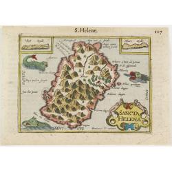
Sancta Helena.
Early miniature map of central part of St Helena island. Title cartouche in the lower right corner. Surrounding the island, three sea monsters are depicted. On both upper...
Place & Date: Amsterdam, 1609
Selling price: $50
Sold in 2008
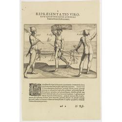
I. Repraesentatio Virorum Quorundamin Avrifero. (Slave, Farmer, Fisherman at the Gold Coast.)
In the foreground, three men engaged in different activities: from right to left, a slave ("akoba") going out to gather wood, an "abaffra," a farmer c...
Place & Date: Frankfurt, 1609
Selling price: $60
Sold in 2018
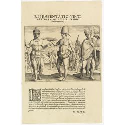
III. Repraesentatio Vestimentorum Quibus Viri in Hoc littore Utuntur. (Male clothing styles at the Gold Coast)
In the foreground, from right to left, a "typical gentleman" wearing a hat and linen clothing. A merchant ("batafou"), with a dog skin hat and a rolle...
Place & Date: Frankfurt, 1609
Selling price: $60
Sold in 2018
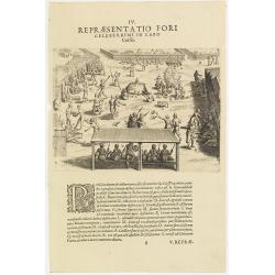
IV. Repraesentatio Fori Celeberrimi in Cabo Corffo. (Market at Cabo Corso)
Market at Cabo Corso at the Gold Coast. Eighteen features, labeled from A to S, are identified in this illustration: (A) the home of the chief, (D) farmers selling palm w...
Place & Date: Frankfurt, 1609
Selling price: $105
Sold in 2013
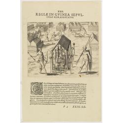
XXII. Regiae in Guinea Sepulturae Repraesentatio.
Headhunters scene in Guinea, according to Theodore de Bry, who was a German engraver and book dealer, began a compilation of early voyages in 1590 and had published six p...
Place & Date: Frankfurt, 1609
Selling price: $80
Sold in 2017
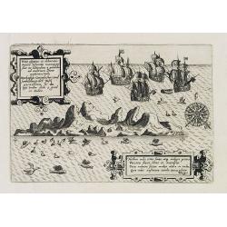
Vera effigies et delineatio Infulce Ascenstio. (St. Helena)
Striking view of the Island of Ascuncion (St. Helena).Theodore de Bry, a German engraver and book dealer, began a compilation of early voyages in 1590 and had published s...
Place & Date: Frankfurt, 1609
Selling price: $170
Sold in 2017
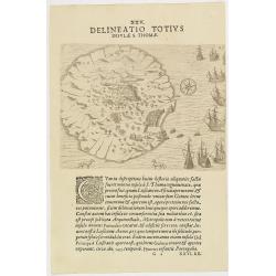
XXV. Delineatio Totius Insulae S. Thomae.
Beautiful untitled map of Sao Tome the principle island of Sao Tome and Principe in the Gulf of Guinea, boats are represented in the sea. Theodore de Bry, a German engrav...
Place & Date: Frankfurt, 1609
Selling price: $100
Sold in 2019
Vera effigies et delineatio Infulce Ascenstio. (St. Helena)
Striking view of the Island of Ascuncion (St. Helena).Theodore de Bry, a German engraver and book dealer, began a compilation of early voyages in 1590 and had published s...
Place & Date: Frankfurt, 1609
Selling price: $150
Sold in 2017
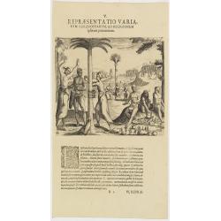
V. Repraesentatio Variarum Ceremoniarum, ad Religionem Ipsorum Pertinentium. (Early fetish print with West African natives.)
Pictorial narrative illustrating the fetish cult to be found along the West coast in what was then Guinea. The description says, the deity "Fetisso" (numinis se...
Place & Date: Frankfurt, 1609
Selling price: $80
Sold in 2019
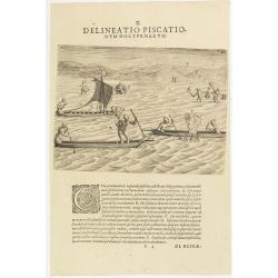
X. Delineatio Piscationum Nocturnarum.
Fishing by night offshore at the coasts of Guinea. The engraving shows a scene of night fishing with nets and traps. The fishermen are in the water or are in a canoe. Som...
Place & Date: Frankfurt, 1609
Selling price: $100
Sold in 2021
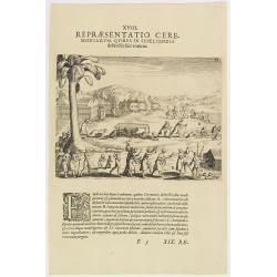
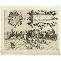
XVIII. Repraesentatio Ceremoniarum, Quibus in Sepeliendis defunctis fuis Utuntur.
Funeral Rites of the Inhabitants of Guinea.Theodore de Bry, a German engraver and book dealer, began a compilation of early voyages in 1590 and had published six parts at...
Place & Date: Frankfurt, 1609
Selling price: $40
Sold in 2023
Guinea and West Africa: Guinea nova Descriptio.
This is an early map of West Africa. It shows an area from the Senegal River and Cape Verde in the north to Cape Lopez below the Equator. There is a detailed inset map...
Place & Date: Amsterdam, (1606) 1613
Selling price: $210
Sold in 2012
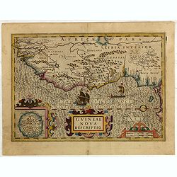
Guineae Nova Descriptio
In 1611 Isaac Pontanus, published his “Rerum et urbis Amstelodamensium historia” in Amsterdam. This print comes out of the even rarer Dutch translation "Historis...
Place & Date: Amsterdam, 1614
Selling price: $250
Sold in 2019
Congi regnu.
Early map of Congo published in the Mercator / Hondius Atlas Minor.
Place & Date: Amsterdam, 1620
Selling price: $100
Sold in 2022
Congi regnu.
Early map of Congo published in the Mercator / Hondius Atlas Minor.
Place & Date: Amsterdam, 1620
Selling price: $50
Sold in 2018
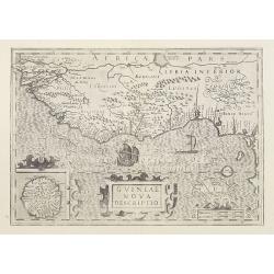
Guineae Nova Descriptio.
This very decorative map shows the West African coast from Senegal (the 'Rio Senega' is the Senegal River) to Cape Lopez on the Gulf of Guinea just below the equator.The ...
Place & Date: Amsterdam, 1623
Selling price: $395
Sold in 2017
Guinea Nova Descriptio
An uncommon map of Guinea with an inset depicting the island of St. Thomas, with an attractive later coloring. Decorated with sea monsters, ships, boats and a decorative ...
Place & Date: Amsterdam, 1623
Selling price: $115
Sold in 2021
Guineae Nova Descriptio.
The map shows the West African coast from Senegal (the 'Rio Senega' is the Senegal River) to Cape Lopez on the Gulf of Guinea just below the equator.The island of St. Tho...
Place & Date: Amsterdam, 1628
Selling price: $200
Sold in 2015
Guineae Nova Descriptio.
The map shows the West African coast from Senegal (the 'Rio Senega' is the Senegal River) to Cape Lopez on the Gulf of Guinea just below the equator.The island of St. Tho...
Place & Date: Amsterdam, 1630
Selling price: $100
Sold
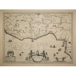
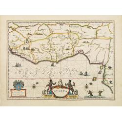
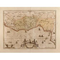
Guinea.
An attractive map, covering the coast from Sierra Leone to Gabon, filed with intersecting rhumb lines and decorated with monkeys, lions, elephants, sea monsters and two c...
Place & Date: Amsterdam, 1635
Selling price: $200
Sold in 2009
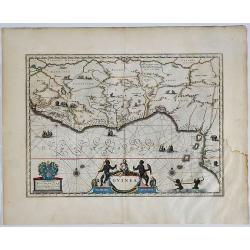
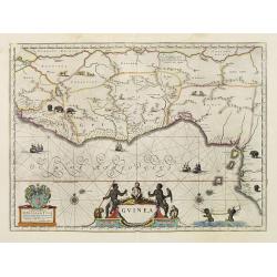
Guinea.
A detailed and decorative map of Guinea, showing the length of a coast important to African-European trade, including the slave trade. Embellished with numerous animals i...
Place & Date: Amsterdam, 1638
Selling price: $200
Sold in 2019
Guinea.
An attractive map covered with intersecting rhumb lines and decorated with monkeys, lions, elephants and native figures. With a dedication to Dr. Nicolas Tulp.
Place & Date: Amsterdam 1640
Selling price: $480
Sold
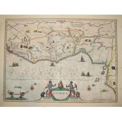
Guinea.
One of the most beautiful and graphic maps to be found, covering the east coast of Africa from Sierrra Leone to Gabon. The interior is decorated with many wild animals, s...
Place & Date: Amsterdam, ca. 1640
Selling price: $525
Sold in 2008
Guinea.
colorful cartouche on the lower border. Two natives sit at the sides of the title, above which is a scroll with flowers and fruit and, in the center, a very human-looking...
Place & Date: Amsterdam, 1644
Selling price: $200
Sold in 2008
Guinea.
colorful cartouche on the lower border. Two natives sit at the sides of the title, above which is a scroll with flowers and fruit and, in the center, a very human-looking...
Place & Date: Amsterdam, ca. 1644
Selling price: $100
Sold in 2018
Guinea.
Samuel Purchas' edition of the Mercator/Hondius "Atlas Minor". Map of Guinea published in his famous collection of voyages "His Pilgrimes". With descr...
Place & Date: London 1645
Selling price: $80
Sold
Carta Particolare della Barberia Australe che comincia con il capo Matas è Finiscie con ilc Himilas con l'Isole di capo Verde.
First state of Dudley?s magnificent chart showing the west coast of Africa including the Cape Verde Islands. Include a sailing ship, notes on prevailing winds and current...
Place & Date: Florence 1645
Selling price: $550
Sold
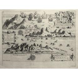
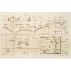
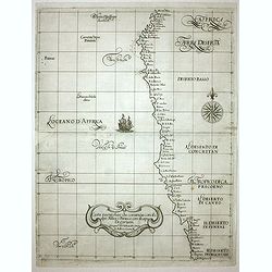
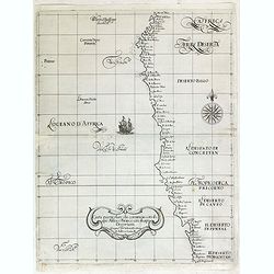
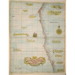
Carta Particolare del mare di Etthiopia con l'Idola di S:Elena è parte della Costa .. Carta VIIII.
First state of Dudley's magnificent showing the west coast of Africa. Include sailing ships, compass card, notes on prevailing winds and currents and more stylized calli...
Place & Date: Florence, 1645
Selling price: $850
Sold in 2008
Carta Particolare che commincia con il fiu me Iuntas nella Guinea è finisce con il capo di S.Dara è con l'Isola d'S:Thmaso. . Carta VI.
First state of Dudley?s magnificent chart showing the coast of New Guinea. Include a sailing ship, compass card, notes on prevailing winds and currents and more stylized ...
Place & Date: Florence 1645
Selling price: $800
Sold
Carta Particolare che comincia con l'Isola di S:Tomaso o Tome è d S. Clara è finisce con il c: d' Aldeas .. Carta VII.
Dudley?s magnificent chart shows the Gulf of Guinea with the Island São Tomé. One of the smaller scale, more specific (?Carta Particolare?) maps and include sailing shi...
Place & Date: Florence 1645
Selling price: $450
Sold
Carta Particolare che comincia con l'Isola di S:Tomaso o Tome è d S. Clara è finisce con il c: d' Aldeas .. Carta VII.
Dudley?s magnificent chart shows the Gulf of Guinea. One of the smaller scale, more specific (?Carta Particolare?) maps and include sailing ships, notes on prevailing win...
Place & Date: Florence 1645
Selling price: $650
Sold
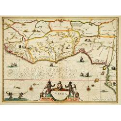
Guinea.
An attractive map covering the coast from Sierra Leone to Gabon, filled with intersecting rhumb lines and decorated with monkeys, lions, elephants, sea monsters, and two ...
Place & Date: Amsterdam, c.1645
Selling price: $300
Sold in 2012
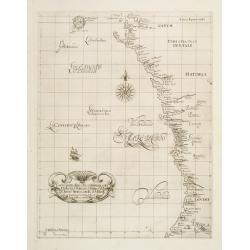
Carta particolare che comincia con il c.apo Aldea e Finisce con il capo Degortam.
Dudley’s magnificent chart shows the south west coast of Africa..Engraved by Lucini.Sir Robert Dudley's Dell'Arcano del Mare is the earliest printed sea atlas to cover ...
Place & Date: Florence, 1645
Selling price: $400
Sold in 2014
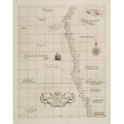
Carta particolare che comincia con il c.apo Aldea e Finisce con il capo Degortam.
Dudley’s magnificent shows the south west coast of Africa. A first edition without the privilege..Engraved by Lucini.Sir Robert Dudley's Dell'Arcano del Mare is the ea...
Place & Date: Florence, 1645
Selling price: $600
Sold in 2015
Carta Particolare che commincia con il capo Aldea è Finisce?
Engraved by Lucini.Sir Robert Dudley's Dell'Arcano del Mare is the earliest printed sea atlas to cover the entire world, and the first made by an Englishman, and the firs...
Place & Date: Florence 1646
Selling price: $305
Sold in 2010
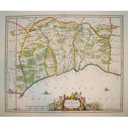
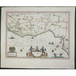
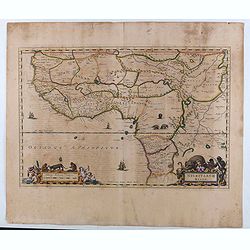
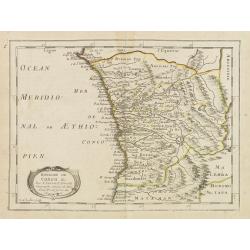
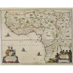
Regna Congo et Angola
A superb delineation of the Congo and Angola as known in the 17th century. Portions of Gabon and Sao Tome are also depicted. Key ports and interior towns are identified a...
Place & Date: Amsterdam, ca. 1650
Selling price: $200
Sold in 2010
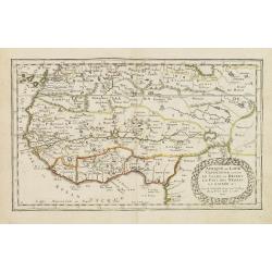
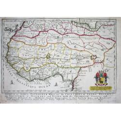
Carte De Nigritie Et Guinee.
Copper engraving map of Nigeria and Guinea, Western Africa, from Mauritania to Zaire. The map has an attractive water mark and a Decorative title cartouche. A highly deta...
Place & Date: Paris, 1653
Selling price: $280
Sold in 2015

Pascaerte van Guinea, en Angola, van R de Gambia tot Cabo de Bona Esperanca.
A sea chart of the Gulf of Guinea, with the neighbouring countries, it shows the coasts and all places. In the sea some boats for decoration and the islands of Fernando, ...
Place & Date: Amsterdam, 1654
Selling price: $300
Sold in 2017
Guinea.
An attractive map covered with intersecting rhumb lines and decorated with monkeys, lions, elephants and native figures. With a dedication to Amsterdam anatomist and phys...
Place & Date: Amsterdam, 1658
Selling price: $450
Sold in 2013
Guinea
Very attractive map of Guinea and Benin. Various animals and ships are shown.Dutch text on verso.
Place & Date: Amsterdam, 1660
Selling price: $220
Sold in 2013
Carte particolare che comincia con l'Isole di S. Tomasso e Tome e c. d' S. Clara e finisce con il. c. d' Aldeas.
Chart of Gabon, Congo, Zaire and Angola] Carte particolare che comincia con l'Isole di S. Tomasso e Tome e c. d' S. Clara e finisce con il. c. d' Aldeas. Description: Rob...
Place & Date: Florence, 1661
Selling price: $500
Sold in 2019
Guinee. (13).
Scarce map of Guinea published by Antoine de Fer in 1661 or 1662 in "Cartes de géographie revues et augmentées". With number 13 in lower right bottom of the m...
Place & Date: Paris, Antoine de Fer, 1657 but 1661 or 1662
Selling price: $220
Sold in 2020
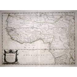
Nigritarum regio.
Blaeu's map of a part of West Africa, from Tropic of Cancer southward including the Senegal River to Angola. The map includes decorative title and scale statement cartouc...
Place & Date: Amsterdam, 1662
Selling price: $120
Sold in 2020
![Del Mina. St. Iago [with] Carmantyn [with] Cabo Verde ofte t. Eijlant Goeree.](/uploads/cache/48507-250x250.jpg)
Del Mina. St. Iago [with] Carmantyn [with] Cabo Verde ofte t. Eijlant Goeree.
Thee engravings on one sheet. View of Elmina, Cormante and the island of Goeree as happened July 1665. Above: the Dutch fleet under Admiral Michiel de Ruyter with three c...
Place & Date: Amsterdam, 1665
Selling price: $45
Sold in 2023
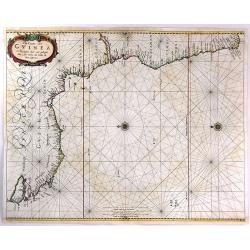
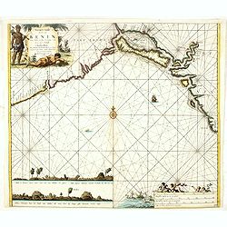
Pas-Caart van Guinea en de Custen daer aen gelegen Van Cabo verde tot Cabo de Bona Esperanca.
A rare sea chart of the southwest coast of Africa from the Guinea Coast down to the Cape of Good Hope, covering Guinea, Sierra Leone, Liberia, the Ivory Coast, Ghana, Nig...
Place & Date: Amsterdam, 1666
Selling price: $280
Sold in 2016
L'Afrique ou Libie ulterieur ou font le Saara ou desert. . .
Map of Guinea coast prepared by N.Sanson and published by Pierre Mariette.Published in an early edition of the small Sanson atlas L'Europe Dediée a Monseigneur . . . Le ...
Place & Date: Paris, P. Mariette, 1667
Selling price: $100
Sold in 2008
Isle du Cap Verd Coste, et pays des Negres. . .
Depicting the West Coast of North Africa and also showing the Cape Verde Islands prepared by N.Sanson and published by Pierre Mariette.Published in an early edition of th...
Place & Date: Paris, P. Mariette, 1667
Selling price: $100
Sold in 2008
Royaume de Congo & c. . .
Decorative map of the Congo on Africa's west coast.An attractive miniature map prepared by N.Sanson and published by Pierre Mariette.Published in an early edition of the ...
Place & Date: Paris, P. Mariette, 1667
Selling price: $120
Sold
Guinee. (inset) I. S. Thomas.
Rare map of Guinea with inset of I. S. Thomas, published by Jollain in 1667. Published in "Trésor Des Cartes Geographiques Des Principaux Estats de Lunivers".T...
Place & Date: Paris, 1667
Selling price: $120
Sold in 2021
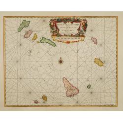
![[Lot of 10 maps / prints of the South Atlantic Ocean islands] CAPEVERDIAN ISLANDS / Insulae Promontorii Viridis.](/uploads/cache/18308-(1)-250x250.jpg)
[Lot of 10 maps / prints of the South Atlantic Ocean islands] CAPEVERDIAN ISLANDS / Insulae Promontorii Viridis.
A map of the Capeverdian islands, embellished with two large and attractive cartouches. With lot of 9 maps / prints of the South Atlantic Ocean islands.
Place & Date: Amsterdam, 1668
Selling price: $200
Sold in 2022
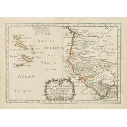
Africa or Libia Ulteriour Where are the Countries of Saara Desert...
Rare map of Western Africa after Sanson. Detailed early Geography with numerous errors of the time. Important mapping of the Canary Islands. The map shows an unusual amou...
Place & Date: London 1669
Selling price: $450
Sold
AFRICA or LIBIA ULTERIOUR Where are the COUNTRIES OF SAARA DESERT the COUNTRIE of NEGROES and GUINE.
A map of Western Africa after Sanson. Detailed early geography with numerous errors typical of the time. Important mapping of the Canary Islands. The map shows an unusual...
Place & Date: London, 1669
Selling price: $300
Sold in 2019
Insulae de Cabo Verde olim Hesperides sive .. Zoute Eylanden.
A beautiful sea chart of these important islands. The map is a re-issue of the map by J.Janssonius. Beautifully embellished with rhumb lines, compass rose and cartouche.
Place & Date: Amsterdam 1670
Selling price: $240
Sold
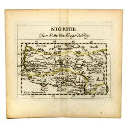
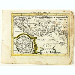
NIGRITIE. Par P. Du VAL Geogr du Roy.
Miniature map of west coast of Africa, showin Guinee, Sahara desert, Congo, Niger, etc.
Place & Date: Paris, c 1670
Selling price: $22
Sold in 2020
Costes de Guinée avec les Royaumes qui y sont connus des Européens, au-dedans des terres, selonn les relations les plus nouvelles . . .
Uncommon map of the Guinea, with fine title cartouche upper right . Dated 1671 and without the inset map added in 1677.
Place & Date: Paris, 1671
Selling price: $450
Sold
Tractus Littorales Guineae a Promontorio Verde..
The West coast of Africa from Mauritania up to Angola. In top centre a very decorative title cartouche.
Place & Date: Amsterdam 1675
Selling price: $1000
Sold in 2008
Tractus Littorales Guineae a Promontorio Verde. . .
The West coast of Africa from Mauritania up to Angola. Classic sea of Dutch school with excellent baroque embellishment. In top center a very decorative title cartouche.
Place & Date: Amsterdam, 1675
Selling price: $260
Sold in 2014
Isles du Cap Verd.
Uncommon miniature map of Cape Verde Islands from Pierre Duval's La Geographie Universeille dated 1676. Following his Cartes de geographie in 1657, Pierre Duval published...
Place & Date: Paris, 1676
Selling price: $30
Sold in 2008
Guinee.
Uncommon miniature map of Guinea and Africa's Gold coast from Pierre Duval's La Geographie Universeille dated 1676. Following his Cartes de geographie in 1657, Pierre Duv...
Place & Date: Paris, 1676
Selling price: $40
Sold in 2009
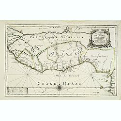
Guinee en de omliggende Landen.
A map of the lands along the Gulf of Guinea.
Place & Date: Utrecht, 1680
Selling price: $45
Sold in 2022
Nigritarum regnum.
Rare and beautiful map of the West coast of Africa with a dedication to Otto Schwerin of Brandenburg. The signature reads Apud Heredes Joannis Janssonii Only a small numb...
Place & Date: Amsterdam, 1680
Selling price: $900
Sold in 2010
Pascaert vande Bocht van Benin..
Uncommon chart showing the coast of Nigeria from Accra (Ghana) till Douala in Cameroon.
Place & Date: Amsterdam, 1680
Selling price: $220
Sold in 2016