Browse Listings in Africa > Central Africa
![[West Africa]](/uploads/cache/34461-250x250.jpg)
[West Africa]
Rare first edition. West Africa, from the Tropic of Cancer south to St Thomas. The interior is filled with lions, elephants, monkeys and camels, with a fenced native vill...
Place & Date: Venice, 1556
Selling price: $472
Sold in 2014
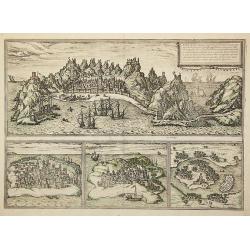
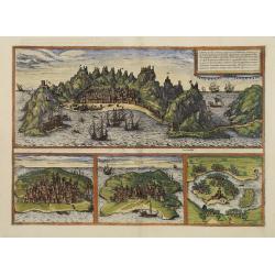
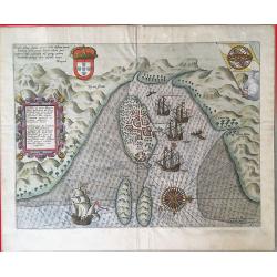
Aden, .../ Mambaza / Quilao / Cefala.
Four town-views of Middle Eastern and East African/Indian Ocean port cities once maintained by the Portuguese in the 16th century as strategic parts of the Lusitanian cro...
Place & Date: Cologne, 1572
Selling price: $300
Sold in 2011
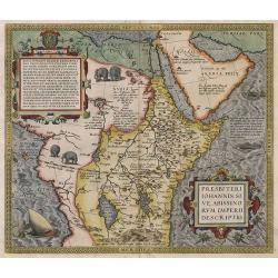
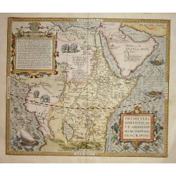
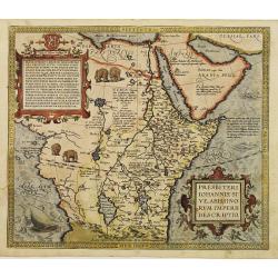
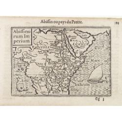
Presbiteri Iohannis, Sive, Abissinorum Imperii Descriptio.
Despite the title this map extends far beyond Prester John's supposed kingdom. It covers Africa from the fabled mountains of the moon in the centre of the continent north...
Place & Date: Antwerp, 1575
Selling price: $1500
Sold in 2010

Arzilla Maxima Quodam Africe Urbs. . .
A city view of Asilah by Braun & Hogeburg. TRANSLATION OF CAPTION: Asilah, formerly the largest city in Africa, is today confined within the narrowest bounds by the C...
Place & Date: Antwerp, 1575
Selling price: $80
Sold in 2020
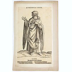
Aethiopis Vxor. (CLXXX)
A African woman standing with floor-length dress. Woodcut by Jost Amman after Weigel. From H. Weigel, "Trachtenbuch". - "The woodcuts have ... above Latin ...
Place & Date: Cologne, ca. 1577
Selling price: $100
Sold in 2019
Presbiteri Iohannis.
Stunning map of the kingdom of the mythical Christian king who according to legend provided a stronghold against Barbarians and was an ally to the crusaders. Ortelius des...
Place & Date: Antwerp 1579
Selling price: $1000
Sold
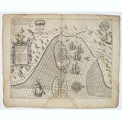
Aden../ Mambaza / Quilao / Cefala.
Three views on one page. In top panoramic view of Aden. In lower part views of Mombasa, Quiloa, and Cefala (or Sofala) near the mouth of the Cuama River in southeast Afri...
Place & Date: Cologne, 1580
Selling price: $1200
Sold in 2011
Presbiteri Iohannis, Sive, Abissin Orum Imperii Descriptio
Despite the title this map extends far beyond Prester John's supposed kingdom. It covers Africa from the fabled mountains of the moon in the center of the continent north...
Place & Date: Antwerp 1590
Selling price: $800
Sold
Tabula Geogra Regni Congo
One of the most beautifully engraved maps of Africa ever produced, ornamented with numerous ships, sea monsters, and elaborate cartouches. One of few early maps to make a...
Place & Date: Frankfurt 1592
Selling price: $225
Sold
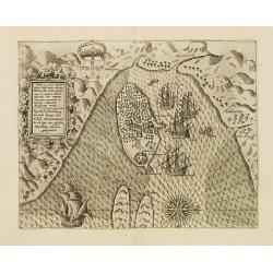
Vera effigies et delineatio Insulae Ascenscio nuncupatae sitae in altitudine 8 graduum ad austrum lineae aequinoctialis.
This is Linschoten's map of Ascension Island in the south Atlantic, beautifully engraved by Baptista a Doetechum.Decorative print showing three coastal views of Ascension...
Place & Date: Amsterdam, c.1596
Selling price: $375
Sold in 2012
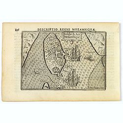
Insulae et arcis MOCAMBIQUE descriptio...Beschrijuinge des..
This is a finely executed copperplate engraved map of Mozambique Island, a strategically important re-supply point for the Portuguese empire in Asia during the 16th centu...
Place & Date: Amsterdam, 1596
Selling price: $130
Sold in 2013
Insulae et arcis Mocambique descriptio ad fines Melinde.
An attractive and rare bird's-eye view of Melinde harbour in Mozambique, engraved by Jan Deutecum for Linschoten's 'Itinerario', published between 1596 and 1644. Probably...
Place & Date: Amstrerdam, 1596
Selling price: $250
Sold in 2020
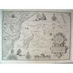
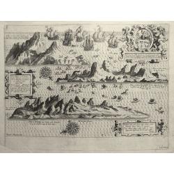
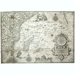
Affbeeldinghe der custen des landts...Terra do Natal.
A superbly decorative early chart engraved by Arnold van Langren showing the African coastline of the Indian Ocean from the Cape to Natal, Mozambique and Madagascar. From...
Place & Date: Amsterdam 1598
Selling price: $3750
Sold
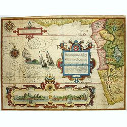
Affbeeldinghe der custen des landts Guinea, Manicongo..
A superbly decorative early engraved by Arnold Van Langren. The ocean is filled with superbly engraved compass spurs, Dutch galleons and elaborate strapwork cartouches. ...
Place & Date: Amsterdam, 1598
Selling price: $3700
Sold in 2008
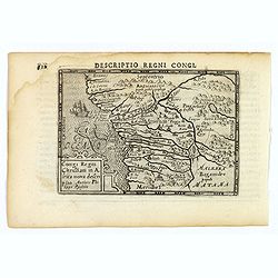
Congi Regni Christiani in Africa.
A fine early miniature map of the West coast of Africa, this map is from the first edition of the Langenes atlas (later well known under the name of Bertius). Dutch text ...
Place & Date: Middelburg, 1598
Selling price: $55
Sold in 2014
Affbeeldinghe der custen des landts...Terra do Natal.
A superbly decorative early chart engraved by Arnold van Langren showing the African coastline of the Indian Ocean from the Cape to Natal, Mozambique and Madagascar. From...
Place & Date: Amsterdam, 1598
Selling price: $850
Sold in 2011
Affbeeldinghe der custen des landts Guinea, Manicongo. . .
A superbly decorative early chart engraved by Arnold van Langren. The ocean is filled with superbly engraved compass spurs, Dutch galleons and elaborate strapwork cartouc...
Place & Date: Amsterdam, 1598
Selling price: $4200
Sold in 2011
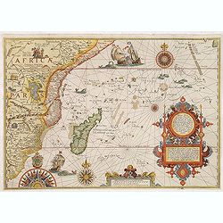
Affbeeldinghe der custen des landts. . .Terra do Natal.
A superbly decorative early chart engraved by Arnold van Langren showing the African coastline of the Indian Ocean from the Cape to Natal, Mozambique, and Madagascar. Fro...
Place & Date: Amsterdam, 1598
Selling price: $1900
Sold in 2013
Affbeeldinghe der custen des landts. . .Terra do Natal.
A superbly decorative early chart engraved by Arnold van Langren showing the African coastline of the Indian Ocean from the Cape to Natal, Mozambique and Madagascar. From...
Place & Date: Amsterdam, 1598
Selling price: $3500
Sold in 2015
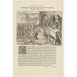
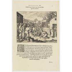
Argumentum II. Lufitani regem Congi falutant, eique legationem fuam exponunt. De quibus Vide lib. 2 cap 2.
The Portuguese appear before the king of the Congo. When the king of the Congo heard about his neighbor, the prince of Sogno, being converted to Christianity, he called t...
Place & Date: Frankfurt, 1598
Selling price: $60
Sold in 2019
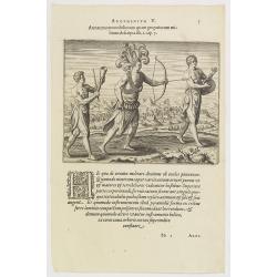
Argumentum V. Armatura tam nobiliorum quam gregariorum militum descripta lib. 1. cap. 7. (How the Congolese dress for war and play)
The distinguished inhabitants of the Congo decorate their head-dresses with ostrich, peacock or other feathers and, wound cross-wise across their bare chests they have ch...
Place & Date: Frankfurt, 1598
Selling price: $90
Sold in 2016
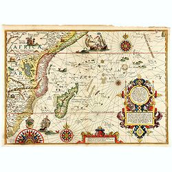
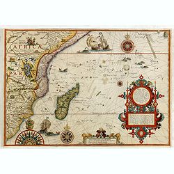
Delineatio orarum maritimarum, terræ vulgo indigetatæ terræ do Natal, item Sofalæ, Mozambicæ & Melindæ, insulæque Sancti Laurentii. . . / Affbeeldinghe der custen des landts genaempt terra do Natal, item van alle de custen van Coffala, Mozambique. .
A superbly decorative early chart engraved by Arnold van Langren showing the African coastline of the Indian Ocean from the Cape to Natal, Mozambique and Madagascar. Tool...
Place & Date: Amsterdam, 1598
Selling price: $4000
Sold in 2020
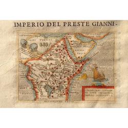
Imperio Del Preste Gianni - Presbeteri Ioannis Sive Abissinorum Imperii Descriptio.
Charming map of the legendary land of the Christian king, Prester John, inset in Italian text (recto and verso). From "La seconda parte delle relazioni universali&qu...
Place & Date: Breschia c. 1599
Selling price: $130
Sold in 2011
Edicti Regii, de quo cap. 3 fecundi libri agitur, executio. (How the king of the Congo had all the devilish idols burnt )
How the king of the Congo had all the devilish idols burnt. After the king of the Congo adopted the Christian religion, he told all his noblemen and servants to hand over...
Place & Date: Frankfurt, 1598-1599
Selling price: $45
Sold in 2017
Abiffinorum Imperium
After A. Ortelius.
Place & Date: Antwerp, c. 1600
Selling price: $170
Sold
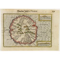
Ins. Sti. Thome
Early miniature map of Saint Thomas from the Caert-Thresoor and engraved by the Dutch master-engraver Petrus Kaerius. The first edition was printed in Middelburg by Baren...
Place & Date: Amsterdam, 1600
Selling price: $40
Sold in 2008
Congi Regni Chriffiani in Africa
Based on the geographical data of Philippo Pigafetta
Place & Date: Amsterdam, c. 1602
Selling price: $110
Sold
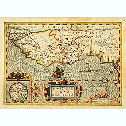
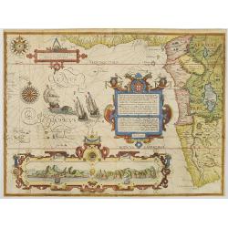
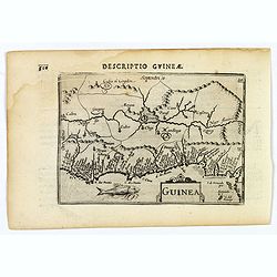
GUINEAE Nova Descriptio.
"The map shows the west coast from Senegal (Rio Senego) to Cape Lopez, just below the equator, and includes Guinea, with a portion of the Benin kingdom and of Lybia....
Place & Date: Amsterdam, 1606
Selling price: $360
Sold
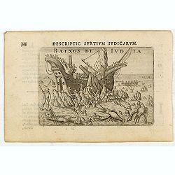
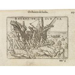
Baixos de Iudia.
Early miniature view of a shipwreck on the islands located between Madagascar and Mozambique. In the foreground, a kind of big lobsters are catching shipwrecked passenger...
Place & Date: Amsterdam, Cornelis Claes, 1606
Selling price: $200
Sold in 2020
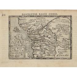
Descriptio Regni Congi.
An attractive miniature map of the Christian Kingdom of Congo in western Africa, published by Petrus Bertius, in Amsterdam at the beginning of the seventeenth century. It...
Place & Date: Amsterdam, 1606
Selling price: $50
Sold in 2021
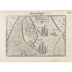
Insulae & Ars Mosambique.
An very attractive miniature map of the Portuguese island of Mozambique in east Africa, published by Petrus Bertius, in Amsterdam at the beginning of the seventeenth cent...
Place & Date: Amsterdam, 1606
Selling price: $45
Sold in 2023
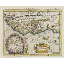
Guinea.
A fine miniature map of the west African region of Guinea, published by Petrus Bertius in Amsterdam early in the seventeenth century. The map and has a strap-work title, ...
Place & Date: Amsterdam, 1606
Selling price: $50
Sold in 2019
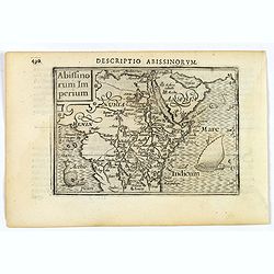
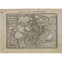
Abissinorum Imperium.
A fine miniature map of the "Empire of Abyssinia", home to the mythical Christian king, Prester John, published by Petrus Bertius in Amsterdam early in the seve...
Place & Date: Amsterdam, 1606
Selling price: $50
Sold in 2019
Insulae et arcis Mocambique descriptio ad fines Melinde sita ebano puriss
Attractive bird's-eye view of Melinde harbor in Mozambique showing the fortifications with numerous ships at anchor in the protected harbor. The map is finely engraved an...
Place & Date: Frankfurt 1607
Selling price: $285
Sold
Guinea.
This Hondius' map of Guinea is probably the most attractive map of this area. An inset with a elaborate strap work border depicts the island of S. Thomas.From the first F...
Place & Date: Amsterdam, 1608
Selling price: $230
Sold in 2010
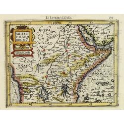
Abissinorum Regnu.
Early map of Central Africa with decorative strap work title cartouche. From the first French-text edition of Jodocus Hondius' Atlas Minor.Shortly after the publication o...
Place & Date: Amsterdam, 1608
Selling price: $150
Sold in 2019
Insula & Arx Mosambique.
Very fine early miniature map of Africa. Title cartouche on the upper left corner : surrounding the continent, three sea monsters and a ship are depicted. The map shows a...
Place & Date: Amsterdam/Frankfurt, 1609
Selling price: $185
Sold in 2008
Insulae et Ars Mosambique / Mozambique.
Very fine early miniature map of Mozambique. Title cartouche on the upper right side. Two ships and three men fishing on a small boat are depicted.First published in 1598...
Place & Date: Amsterdam/ Frankfurt 1609
Selling price: $120
Sold in 2015
Baixos de Iudia.
Early miniature view of a shipwreck on the islands located between Madagascar and Mozambique. In the foreground, a kind of big lobsters are catching shipwrecked passenger...
Place & Date: Amsterdam / Frankfurt, 1609
Selling price: $150
Sold in 2009
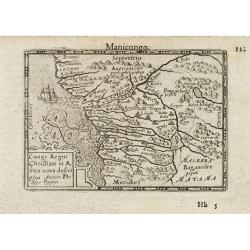
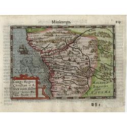
Congo Regni Christiani in Africa / Manicongo.
Early miniature map of central part of Africa, from Guinea to Angola. Title cartouche in the lower left corner.First published in 1598 in his Caert-Thresoor, the plates w...
Place & Date: Amsterdam / Frankfurt 1609
Selling price: $100
Sold in 2009