Search Listings matching "pictorial-maps" in America

A Hysterical Map Of Death Valley National Monument -- And It's Looking Mighty Low
First edition Humorous map of Death Valley. "Drawn In Broken English by Jolly Lindgren," this comic pictorial map is full of puns and comic vignettes related to...
- $500 / ≈ €468
Place & Date: Spokane, Wash., Lindgren Brothers, 1948
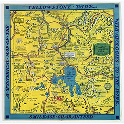
The Famous Hysterical Map of Yellowstone Park, including a few minor Changes.
A lovely whimsical map of America's Yellowstone Park, published about the time of President Franklin Roosevelt's "New Deal" for America in 1936. To emphasise th...
- $450 / ≈ €421
Place & Date: America, ca 1936
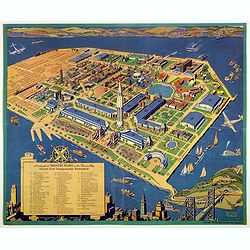
A cartograph of Treasure Island in San Francisco Bay Golden Gate International Exposition.
Ruth Taylor White's large format map of Treasure Island and the San Francisco Golden Gate Exposition Fairgrounds, published in 1940.The map provides an aerial panorama of...
- $200 / ≈ €187
Place & Date: San Francisco, 1940

The Greyhound Map of This Amazing America. . .
A large colored lithograph map of the USA, published by the Greyhound Corporation during the second world war. The map demonstrates where all the Greyhound bus routes int...
- $150 / ≈ €140
Place & Date: United States, 1941
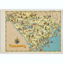
South Carolina.
A fun, humorous, whimsical map of South Carolina by Ruth Taylor White. With vibrant colors.The state is filled with delightful cartoonish characters, some pursuing assort...
- $125 / ≈ €117
Place & Date: Boston, ca 1935