Browse Listings in Europe
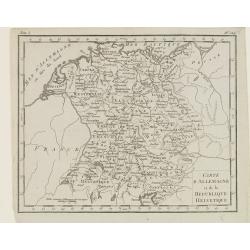
Carte d'Allemagne et de la Republique Helvetique.
Map of central Europe centered on Germany, extending southwards and eastwards to include Poland, the Czech Republic, Austria, Switzerland, Slovenia and part of Italy.From...
Place & Date: Paris, Prudhomme, Levrault, Debray, 1806
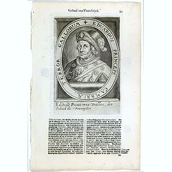
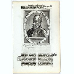
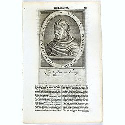
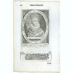
Eduardus Princeps Cambriae, Terror Gallorum.
The engraving depicts a half length oval portrait of Edward Prince of Wales. Nicolaes de Clerck (de Klerc) was active as engraver and publisher in Delft from 1599-1621.In...
- $25 / ≈ €23
Place & Date: Amsterdam, Cloppenburch, 1621
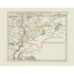
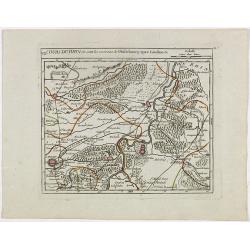
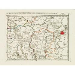
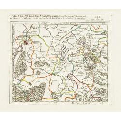
X. Carte du Comté de Namur où se trouvent les environs de Dinant.
Attractive small map showing an area straddling the border between France and Belgium.It shows Dinant, Ciney, and the fort of Charlemont, built by Charles V on the French...
- $30 / ≈ €28
Place & Date: Paris, 1799
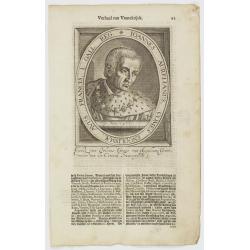
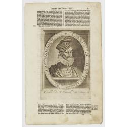
Ioannes Aurelianus, Comes Engolismae, Avus Francis. I. Gall. Reg.
The engraving depicts a half length oval portrait of John of Orléans, Count of Angoulême and of Périgord (1399 – 1467), was a younger son of Louis I, Duke of Orléan...
- $20 / ≈ €19
Place & Date: Amsterdam, Cloppenburch, 1621
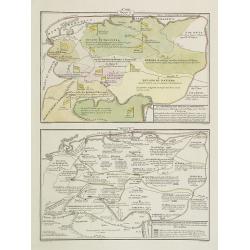
La Germania, suoi ducati e dependenze . . . /Origine e derivazione de principali stati . . .
Two rare maps of ancient Germany: Top map: 160 x 235mm. Bottom map: 160 x 235mm.Prepared by Las Casas for l'Atlante Storico, Letterario, Biografico, Archeologico. . . wi...
- $25 / ≈ €23
Place & Date: Venice, 1840
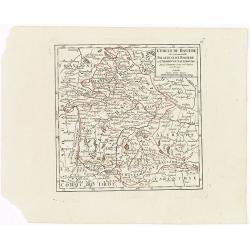
Cercle de Baviere où se trouvent le Palatinat de Baviere et l'Archev. De Saltzbourg.
Small detailed map of the southeastern part of Bavaria, including part of Austria. From Atlas Portatif Universel, by Robert de Vaugondy.Edited by : "Au dépôt de G�...
- $30 / ≈ €28
Place & Date: Paris, 1799
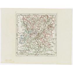
Cercle des quatre Electeurs.
Small detailed map of part of western Germany, centered on Frankfurt. From Atlas Portatif Universel, by Robert de Vaugondy.Edited by : "Au dépôt de Géographie, Ru...
- $25 / ≈ €23
Place & Date: Paris, 1799
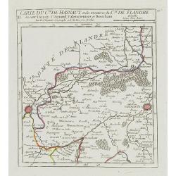
III. Carte du C.té de Haynaut et des Frontieres du C.té de Flandre..
Attractive small map encompassing part of the Nord, between Douai and Valenciennes.From Atlas Portatif Universel, by Robert de Vaugondy.Unrecorded state with erased date....
- $50 / ≈ €47
Place & Date: Paris, after 1748
The attempt on the Czar's life: The Grand Ball-Room . . .
A panorama of the Winter Palace with an attempt on the Czar's life published in the Illustrated London News of 28 February, 1880.
- $15 / ≈ €14
Place & Date: London, 28 February, 1880
Carolus IX. D. G. Galliarum Rex Christianissimus.
The engraving depicts a half length oval portrait of Charles IX of France.Nicolaes de Clerck (de Klerc) was active as engraver and publisher in Delft from 1599-1621.Inclu...
- $20 / ≈ €19
Place & Date: Amsterdam, Cloppenburch, 1621
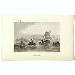
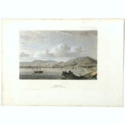
Archangel.
Steel engraving of Archangel, published by the German publishing company Bibliographisches Institut which was founded 1826 in Gotha by Joseph Meyer, moved 1828 to Hildbur...
- $25 / ≈ €23
Place & Date: Hildburghausen, 1850
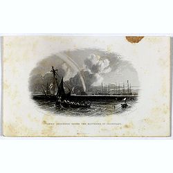
Taking soundings under the batteries of Cronstadt.
Steel engraving showing a small boat taking soundings under the batteries of Kronstadt from a drawing by J. W. Carmichael, engraved by E. Brandard. From "The History...
- $20 / ≈ €19
Place & Date: London, Virtue, ca. 1857
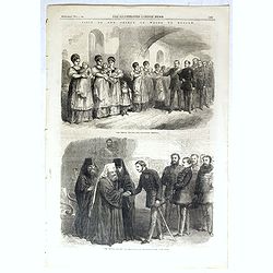
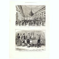
The Prince visiting the foundling hospital. / The Prince visiting the Metropolitan Archbishop.
Two engravings shown Albert Edward the Prince of Wales visiting Moscow from the Illustrated London News.
- $10 / ≈ €9
Place & Date: London, 1866
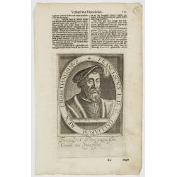
Franciscus I. D. G. Galliarum Rex Christianissimus.
The engraving depicts a half length oval portrait of Francis I of France.Nicolaes de Clerck (de Klerc) was active as engraver and publisher in Delft from 1599-1621.Includ...
- $20 / ≈ €19
Place & Date: Amsterdam, Cloppenburch, 1621
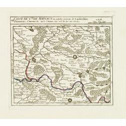
VIII. Carte du C.té de Haynaut où sont les environs de Landrechies..
Attractive small map showing an area straddling the regions Picardy and Nord. It shows the towns of La Capelle, Landrecies and Avesnes-sur-Helpe.From Atlas Portatif Unive...
- $30 / ≈ €28
Place & Date: Paris, 1799
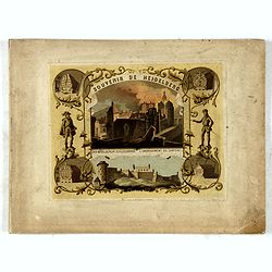
(Title page) Souvenir de Heidelberg.
Cover for a souvenir album with chromolithographed design and entitled: Souvenir de Heidelberg prepared by Louis Charles François. He emigrated with his family in May 17...
- $50 / ≈ €47
Place & Date: Graimberg, Heidelberg, ca. 1840
Comté de Tirol, et Evêché de Brixen.
Small detailed map of Tirol and the Italian Alto-Adige region, centered on Innsbruck. From Atlas Portatif Universel, by Robert de Vaugondy.Edited by : "Au dépôt de...
- $30 / ≈ €28
Place & Date: Paris, 1799
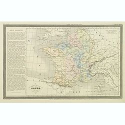
Gaule.
Finely engraved map prepared by A.H.Dufour and engraved by Giraldon-Bovinet. Published by Jules Renouard in his uncommon atlas "Le globe Atlas classique Universel de...
- $20 / ≈ €19
Place & Date: Paris, Jules Renouard, ca.1840
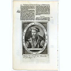
Fredericus II. D. G. Daniae Et Norvegiae Rex. Dux Holsatiae etc.
The engraving depicts a half length oval portrait of "Fredericus II".Nicolaes de Clerck (de Klerc) was active as engraver and publisher in Delft from 1599-1621....
- $20 / ≈ €19
Place & Date: Amsterdam, Cloppenburch, 1621
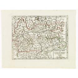
VII. Cours du Rhin où sont les environs de Philisbourg, Spire Landaw &c.
Small detailed map illustrating the stretch of the Rhine which flows between Germersheim and Speyer.From Atlas Portatif Universel, by Robert de Vaugondy. Edited by : &quo...
- $25 / ≈ €23
Place & Date: Paris, 1799
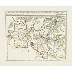
VII. Carte des Frontieres du Luxembourg.. Yvoix &c.
Detailed small map showing an area straddling the border between France and Belgium.From Atlas Portatif Universel, by Robert de Vaugondy. Edited by : "Au dépôt de ...
Place & Date: Paris, later than 1749
Leo X. Pontifex Maximus Florentinus Sedit Annos 8 Menses 8. / Paulus Quartus Neapolitanus Pontifex Maximus..
The engraving depicts a half length oval portrait of the Pope "Leo X", signed lower right corner N. de Cleck".On verso a half length oval portrait of "...
- $15 / ≈ €14
Place & Date: Amsterdam, Cloppenburch, 1621
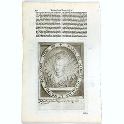
Maria De Medices D. G Galliae et Navarrae Reg. Uxor Henr. IIII.
The engraving depicts a half length oval portrait of Marie de' Medici, queen consort of France .Nicolaes de Clerck (de Klerc) was active as engraver and publisher in Delf...
- $15 / ≈ €14
Place & Date: Amsterdam, Cloppenburch, 1621
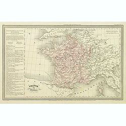
France par Provinces.
Finely engraved map prepared by A.H.Dufour and engraved by Giraldon-Bovinet. Published by Jules Renouard in his uncommon atlas "Le globe Atlas classique Universel de...
- $30 / ≈ €28
Place & Date: Paris, Jules Renouard, ca.1840
Christianus III. D. G. Daniae Et Norwegiae Rex. Dux Hols. etc.
The engraving depicts a half length oval portrait of "Christianus III".Nicolaes de Clerck (de Klerc) was active as engraver and publisher in Delft from 1599-162...
- $20 / ≈ €19
Place & Date: Amsterdam, Cloppenburch, 1621
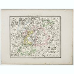
Le Vie Ferrate e le Strade Postali della Germania centrale e meridionale . . .
Uncommon map of Germany and part of France and Switzerland prepared by Francesco Costantino Marmocchi. Above the map "Geografia Commerciale". From "Il Glob...
- $25 / ≈ €23
Place & Date: Genova, Paolo Rivara fu Giacomo, 1858
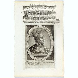
Fridericus I. D. G. Daniae Et Norvegiae Rex. etc.
The engraving depicts a half length oval portrait of "Fridericus I".Nicolaes de Clerck (de Klerc) was active as engraver and publisher in Delft from 1599-1621.I...
- $20 / ≈ €19
Place & Date: Amsterdam, Cloppenburch, 1621
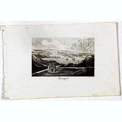
Sewastopol. (Sebastopol)
View of Sebastopol. Engraved by Leopold Zechmayer who was active in Vienna.
- $20 / ≈ €19
Place & Date: Vienna, ca. 1835
IX. Carte du D.ché du Luxembourg.. Diekirch &c.
Charming small map representing the area between Luxembourg and Trier. From Atlas Portatif Universel, by Robert de Vaugondy.Edited by : "Au dépôt de Géographie, R...
Place & Date: Paris, later than 1749
Kertsch im südlichen Russland. (Kerch)
Steel engraving with a panoramic view of the town of Krech, published in "Meyers Universum oder Abbildung und Beschreibung des Sehenswerthesten und Merkwürdigsten d...
- $15 / ≈ €14
Place & Date: Hildburghausen, 1848
Lodovicus XIII. D. G. Galliae Et Navarrae Rex Christianiss.
The engraving depicts a half length oval portrait of Louis XIII of France.Nicolaes de Clerck (de Klerc) was active as engraver and publisher in Delft from 1599-1621.Inclu...
- $25 / ≈ €23
Place & Date: Amsterdam, Cloppenburch, 1621
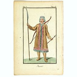
Jacout.
Originally hand-colored mezzotint from 'Costumes civils actuels de tous les peuples connus'. Originally hand-colored mezzotint of Native Americans engraved by Félix Mix...
- $50 / ≈ €47
Place & Date: Paris,1801-1806
![S. Victor in Franckr. [The Abbey of St. Victor near Paris.].](/uploads/cache/13769-250x250.jpg)
S. Victor in Franckr. [The Abbey of St. Victor near Paris.].
A very nice view of the Abbey of St. Victor near Paris. On the foreground, a night watchman is depicted. With a verse in two languages underneath the picture.The poet Dan...
- $60 / ≈ €56
Place & Date: Frankfurt, 1623-1678
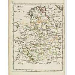
Cercle de Westphalie.
Fine map of North Rhine-Westphalia. George Louis Le Rouge was active from 1740 till 1780 as a publisher, and was appointed engineer for the King of France. From his Atlas...
- $30 / ≈ €28
Place & Date: Paris 1756
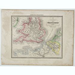
Le Vie Ferrate e Postali dell' Inchilterra . . .
Uncommon map of England and part of France prepared by Francesco Costantino Marmocchi. Above the map "Geografia Commerciale". From "Il Globo Atlante di car...
- $25 / ≈ €23
Place & Date: Genova, Paolo Rivara fu Giacomo, 1858
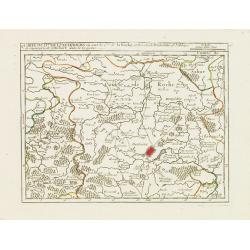
V. Carte du D.hé de Luxembourg.. dans le Lyegeois.
Charming small map representing part of Luxembourg, the southernmost province of Wallonia and of Belgium. Centered on Bastogne.From Atlas Portatif Universel, by Robert de...
Place & Date: Paris, later than 1749
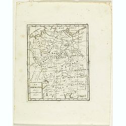
La Germania divisa ne' suoi differenti stati
Rare map of Germany, from "Atlante Novissimo ad uso Dei Giovani Studiosi Contenuto In Carte XXVII.", published by Giovanni Zempel in Rome, ca. 1780.The map is b...
- $25 / ≈ €23
Place & Date: Rome, 1780
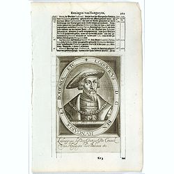
Lodovicus D.G. Rex Hungariae et Bohemiae Etc.
The engraving depicts a half length oval portrait of "Lodovicus D.G. Rex Hungariae et Bohemiae".Nicolaes de Clerck (de Klerc) was active as engraver and publish...
- $15 / ≈ €14
Place & Date: Amsterdam, Cloppenburch, 1621
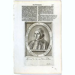
Adrians VI. Pontifex Maximus Ultraiectinus Vixit Annos 64 1/2.
The engraving depicts a half length oval portrait of Pope Adrian VI, born Adriaan Florensz (Boeyens) (1459 ? 1523), was born in the Prince-Bishopric of Utrecht in the Net...
- $25 / ≈ €23
Place & Date: Amsterdam, Cloppenburch, 1621
IV. Carte du Duché de Luxembourg où sont les Seign.ries de Lompré..
Charming small map representing part of Luxembourg, the southernmost province of Wallonia and of Belgium.From Atlas Portatif Universel, by Robert de Vaugondy. Edited by :...
Place & Date: Paris, later than 1749