Search Listings matching "Mannevillette" in Africa
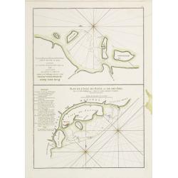
Plan des Isles Querimbo, Oybo, et Matemo / Plan de l'Ile de Patte et de son Port.
French sea chart of Isles Patte, Querimbo, Oybo, Matemo on East coast of Madagascar. Latitude and longitude scales, compass rose and system of rhumb lines, soundings near...
- $75 / ≈ €70
Place & Date: Paris, Brest, chez Demonville, 1775
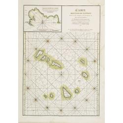
Carte des Iles du Cap-Verd Dressée sur les remarques et les observations les plus exactes des Navigateurs.
French sea chart of the Cap Verde Islands, situated 570 kilometers off the coast of Western Africa.Latitude and longitude scales, compass rose and system of rhumb lines, ...
- $100 / ≈ €94
Place & Date: Paris, Brest, chez Demonville, 1775
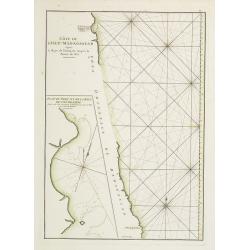
Côte de l'Isle de Madagascar depuis la Baye de Vohemare jusqu'à la pointe de l'Est. Plan du Port et de la Baye du Cap de l'Est.
French chart of the east coast of Madagascar.Latitude and longitude scales, compass rose and system of rhumb lines, soundings near coast and in bay areas.D' Après de Man...
- $100 / ≈ €94
Place & Date: Paris, Brest, chez Demonville, 1775
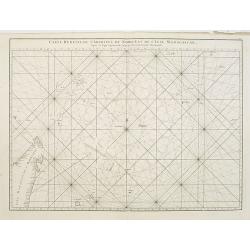
Carte réduite de l'Archipel du Nord-Est de l'Ile Madagascar.
French sea chart of an archipelago off the coast of Madagascar. The northeastern coast of Madagascar is included.Latitude and longitude scales, compass rose and system of...
- $100 / ≈ €94
Place & Date: Paris, Brest, chez Demonville, 1775
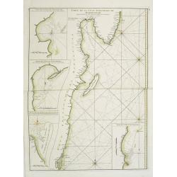
Carte Orientale de Madacascar Depuis la Rivière Ivondrou jusqu'à Mananzari.
Large sea sea chart of the southeast coastline of Madagascar and four inset maps of the harbors and anchorage of Tamatave, Foulpointe, Teintingue und Veninguebe. Inset ma...
- $125 / ≈ €117
Place & Date: Paris, Brest, chez Demonville, 1775

Plan du Cap de Bonne-Esperance et ses environs..
Large and detailed sea chart of the Cape of Good Hope from Saldahna Bay to False Bay.Engraved by Guillaume-Nicolas Delahaye (1727-1802).Latitude and longitude scales, com...
Place & Date: Paris, 1745

Carte particulière de la côte d'Afrique depuis le cap des Courans jusqu'à la baye de Ste Hélène. . .
Large and detailed sea chart of South Africa.Engraved by Guillaume-Nicolas Delahaye (1727-1802).Latitude and longitude scales, compass rose and system of rhumb lines, sou...
Place & Date: Paris, 1745