Search Listings matching "cyprus" in Asia > Holy Land & Jerusalem
![.[Near east with Cyprus]](/uploads/cache/33857-250x250.jpg)
.[Near east with Cyprus]
Wood block printed map and one of earliest printed representation of Near east with Cyprus prepared by Martin Waldseemüller. Based on the slightly larger map from 1513 p...
Place & Date: Vienna, 1525 -1541

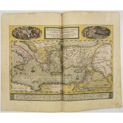
Peregrinationis Divi Pauli Typus corographicus. . .
A splendid map depicting the travels of Paulus. With two fine scenes in top. Showing the countries along the Mediterranean, including Cyprus and Italy. A first edition wi...
Place & Date: Antwerp, 1595

Quella Tavola E l'Antica Siria ch'Era destinta in dodici . . .
Very rare view of Holy Land published in the first edition of "Viaggio da Venetia, a Costantinopoli. Per Mare, e per Terra, & infieme quello di Terra Santa. Da G...
Place & Date: Venice, Giacomo Franco, 1598
Peregrinationis Divi Pauli Typus..
A splendid map depicting the travels of Paulus. With two fine scenes in top. Showing the countries along the Mediterranean, including Cyprus and Italy. A first edition wi...
- $1500 / ≈ €1404
Place & Date: Antwerp, 1584
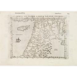
Soria et Terra Santa nuova tavola.
Early map of this classical map of the Holy Land, including Cyprus, prepared by Giovanni Botero. The copper plate was however later used by Giuseppe Rosaccio's expended e...
- $500 / ≈ €468
Place & Date: Venice, 1598
![[Map of the Holy Land, including Cyprus]](/uploads/cache/33436-250x250.jpg)
[Map of the Holy Land, including Cyprus]
Attractive full page longitudinal map of Palestine, Syria and Cyprus, cut by Hans Rudolf Manuel Deutsch. The shore line running from Southern Anatolia to the Nile Delta. ...
Place & Date: Basle, 1550-1580

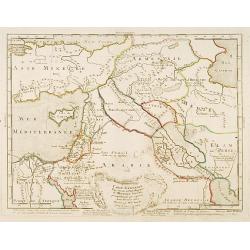
Tabula Asiae IIII. (Cyprus, Holy Land, Syria, Jordan, Iraq)
Gastaldi's map showing Cyprus, the Holy Land, Syria, Jordan and Iraq, based upon Ptolemy's map It is one of the earliest obtainable maps of the region.From Giacomo Gastal...
- $350 / ≈ €328
Place & Date: Venice, 1548
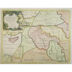
Afbeelding van all de Landen gelegen tusschen de Middellandsche, Zwarte, Caspische, Persische en Rode Zeën.
A map of the Near East, with an oversized Cyprus. From a Dutch bible published by Nicolaas Goetzee. Willem Albert Bachiene (1712-1783), Dutch geographer in Maastricht. Mo...
- $300 / ≈ €281
Place & Date: Gorichem, Nicolaas Goetzee, 1748
Carte générale pour servir à l'Intelligence de..
Fine map of the Middle East, including the Holy Land, Cyprus, Iran and Irak, etc.Philippe Buache was one of the most active proponents of the so-called, "school of t...
- $300 / ≈ €281
Place & Date: Paris, 1783
![[De terra sancta.]](/uploads/cache/32540-250x250.jpg)
[De terra sancta.]
On verso a map of the Middle East with Syria, Israel and Cyprus (123x158mm.). From a Latin text edition of his Geographia , that great compendium of Renaissance knowledge...
- $50 / ≈ €47
Place & Date: Basle, 1550-1590