Browse Listings
![Instruments des insulaires de la Mer du Sud. [Tome II Pl. 15.]](/uploads/cache/26097-250x250.jpg)
Instruments des insulaires de la Mer du Sud. [Tome II Pl. 15.]
Divers tools. From the French edition of James Cook's first voyage entitled Relation des voyages entrepris par ordre de sa Majesté Britannique actuellement régnante pou...
- $15 / ≈ €14
Place & Date: Paris, 1773
![Hausse-col militaire des insulaires de la Mer du Sud. [Tome II Pl. 12.]](/uploads/cache/26095-250x250.jpg)
Hausse-col militaire des insulaires de la Mer du Sud. [Tome II Pl. 12.]
Maori warrior rise-collar. From the French edition of James Cook's first voyage entitled Relation des voyages entrepris par ordre de sa Majesté Britannique actuellement ...
- $25 / ≈ €23
Place & Date: Paris, 1773
![[71] Barbarie.](/uploads/cache/12843-250x250.jpg)
[71] Barbarie.
Charming chart of the harbour of the province of Barbarie in Syria. Showing town and harbour plan, with soundings, anchorages, rocks, shoals, fortifications and lighthous...
- $50 / ≈ €47
Place & Date: Marseille 1764

Paris fashion plate. (584)
From Les Modes Parisiennes. Underneath the print are the names of the shops where the clothing's, perfumes, porcelains, flowers, etc., depicted in the engraving, are to b...
- $30 / ≈ €28
Place & Date: Paris, 1866
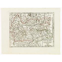
Cercle de Baviere où se trouvent le Palatinat de Baviere et l'Archev. De Saltzbourg.
Small detailed map of the southeastern part of Bavaria, including part of Austria. From Atlas Portatif Universel, by Robert de Vaugondy.Edited by : "Au dépôt de G�...
- $30 / ≈ €28
Place & Date: Paris, 1799
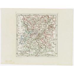
Cercle des quatre Electeurs.
Small detailed map of part of western Germany, centered on Frankfurt. From Atlas Portatif Universel, by Robert de Vaugondy.Edited by : "Au dépôt de Géographie, Ru...
- $25 / ≈ €23
Place & Date: Paris, 1799
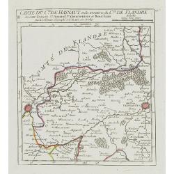
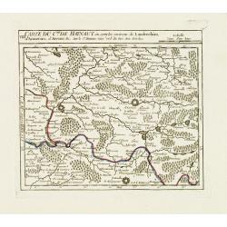
III. Carte du C.té de Haynaut et des Frontieres du C.té de Flandre..
Attractive small map encompassing part of the Nord, between Douai and Valenciennes.From Atlas Portatif Universel, by Robert de Vaugondy.Unrecorded state with erased date....
- $50 / ≈ €47
Place & Date: Paris, after 1748
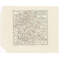
Comté de Tirol, et Evêché de Brixen.
Small detailed map of Tirol and the Italian Alto-Adige region, centered on Innsbruck. From Atlas Portatif Universel, by Robert de Vaugondy.Edited by : "Au dépôt de...
- $30 / ≈ €28
Place & Date: Paris, 1799
VIII. Carte du C.té de Haynaut où sont les environs de Landrechies..
Attractive small map showing an area straddling the regions Picardy and Nord. It shows the towns of La Capelle, Landrecies and Avesnes-sur-Helpe.From Atlas Portatif Unive...
- $30 / ≈ €28
Place & Date: Paris, 1799

Paris fashion plate 577.
From Les Modes Parisiennes. Underneath the print are the names of the shops where the clothing's, perfumes, porcelains, flowers, etc., depicted in the engraving, are to b...
- $40 / ≈ €37
Place & Date: Paris, 1866