Browse Listings in Europe > Scandinavia
Die Götha-Elf. Nach Friedr. Akrel's Plancharta öfver Trollhättan reducirt.
Uncommon map prepared by Carl Frederik Akrell. Showing the River Gotha from Gothenburg till Vänersborg.Published by Geographisen Institut in Weimar. A scale in Swedish m...
- $100 / ≈ €94
Place & Date: Weimar, 1805
![[Fan shaped shopping guide to Stockholm.]](/uploads/cache/44788-250x250.jpg)
[Fan shaped shopping guide to Stockholm.]
A highly unusual and interesting vintage fan-shaped map of Stockholm to illustrate a 'Shopping guide to Stockholm'. Text written in English. With ten fold-out panels prin...
- $200 / ≈ €187
Place & Date: Stockholm, 1960
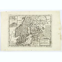
Sweden and Norway.
Herman Moll's mid eighteenth century map of Sweden and Norway, extending down to Denmark, across to Finland, and south to the Baltic states of Estonia, Livonia etc. With ...
- $125 / ≈ €117
Place & Date: London, ca 1750
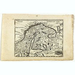
Norvege et Suede.
Rare map of Norway, Sweden and Finmark published by Jollain in 1667. Published in "Trésor Des Cartes Geographiques Des Principaux Estats de Lunivers".This atla...
- $250 / ≈ €234
Place & Date: Paris, 1667

De custen van een deel van Denemarken en Swede. . .
A detailed chart of the coast Skane and Kalmar, with the island Öland. Decorated by a title and scale cartouche, a compass rose, several vessels and sea monsters, and de...
- $2000 / ≈ €1871
Place & Date: Leiden, Plantijn, 1585
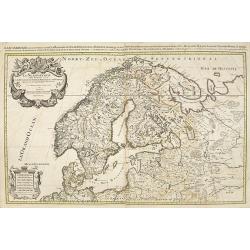
La Scandinavie et les environs, ou sont le royaumes de Suede de Danemarck, et de Norwege . . .
Fine map of Scandinavia and the Baltic States with rococo title cartouche with a dedication to Le Dauphin with his coat of arms. A separate scale cartouche in lower left ...
- $500 / ≈ €468
Place & Date: Amsterdam, 1694
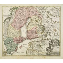
Tabula exactissima Regnorum Sueciae et Norvegiae..
Very fine and uncommon map of Scandinavia, after Andreas Buraeus, the father of Swedish cartography, whose map was compiled from original survey work. Dedicated to Gustav...
- $750 / ≈ €702
Place & Date: Amsterdam, 1680
Les Royaumes De Suede Norwege et Danemark. . .
Scarce map of Scandinavia with inset map of Spitsbergen and northern coast of Lapland. Prepared by Nolin and published by L.J. Mondhare for his Atlas Général a l'usage ...
- $100 / ≈ €94
Place & Date: Paris, 1783
Scandinavia complectens Sueciae, Daniae & Norvegia. . .
Johann Baptist Homann's well-engraved map has a large decorative cartouche. Detailed map of Scandinavia.Johann Baptist Homann (1663-1724) was a German engraver and publis...
- $350 / ≈ €328
Place & Date: Nuremberg, 1747
Habillement des Groënlandais.
Natives of Greenland. This aquatint engraved plate was color printed on fine wove paper of a soft aged white color, bearing the embossed seal of authenticity impressed at...
- $75 / ≈ €70
Place & Date: Milan, 1827
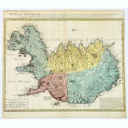
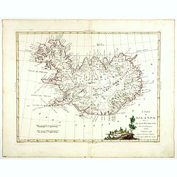
Carte de l'Islande pour servir á la continuation de l'histoire générale des voyages. Dressée sur celle de M. Horrebows.
A good engraved map of the island Iceland, prepared by Bellin after M. Horrebows, with rococo title cartouche in lower right. From l'Histoire générale des voyages.
- $300 / ≈ €281
Place & Date: Paris, 1758

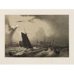
Mare Balticum. . . / Nieuwe Pascaert van de Oost Zee. . .
Decorative chart showing the Baltic sea, with a splendid cartouche of royal figures. A re-issue of the De Wit copper plates, now with many improvements.
- $2500 / ≈ €2339
Place & Date: Amsterdam ca.1680
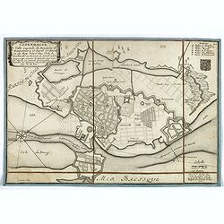
Copenhague ville capitale du royaume de Dannemarq et séjour ordinaire du Roy . . .
Separately published town-plan of Copenhagen, also published in de Fer's "Curious Atlas". Engraved by C.Inselin. Plan is dated 1700 in lower right corner. With ...
- $150 / ≈ €140
Place & Date: Paris, 1700
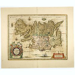
Tabula Islandiae. . .
With a very decorative cartouche, and a very fine imprint. No text on verso; included in the rare "Appendix" of 1630. VERY RARE. This handsome map of Iceland wa...
- $1500 / ≈ €1404
Place & Date: Amsterdam, 1630
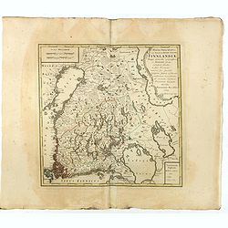
MAGNI PRINCIPATUS, ceu Provinciae REGNI SUECIAE, FINNLANDIAE Mappa generalis geographica : ex HASIANIS aliisque certissimis subsidiis, in suas Provincias minores sive speciales, tanquam statum politicum modernum . . .
A large and rarely seen map of Finland prepared by Haas. Extends from St. Petersburg north to well above the Gulf of Bothnia.
- $700 / ≈ €655
Place & Date: Nuremberg, 1789
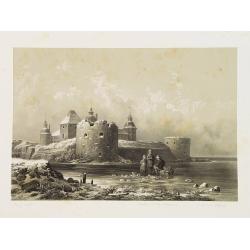
Château de Calmar (Suède).
Uncommon and decorative lithography published by Carl Johan Billmark and printed by Lemercier in Paris, 55 rue de Seine, the leading firm in Europe at that time. From: It...
- $125 / ≈ €117
Place & Date: Paris, c.1859
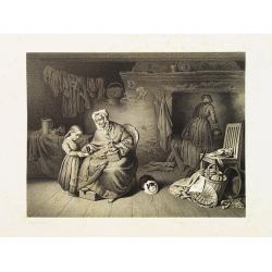
Bonheur de la Grand-mère.
Uncommon and decorative lithography published by Carl Johan Billmark and printed by Lemercier in Paris, 55 rue de Seine, the leading firm in Europe at that time. From: It...
- $40 / ≈ €37
Place & Date: Paris, c.1859
Château de Stegeborg (Suède).
Uncommon and decorative lithography published by Carl Johan Billmark and printed by Lemercier in Paris, 55 rue de Seine, the leading firm in Europe at that time. From: It...
- $100 / ≈ €94
Place & Date: Paris, c.1859
Kronborg et le Sund (Danemarck).
Uncommon and decorative lithography published by Carl Johan Billmark and printed by Lemercier in Paris, 55 rue de Seine, the leading firm in Europe at that time. From: It...
- $75 / ≈ €70
Place & Date: Paris, c.1859
Maison de Chasse de Charles XI (Suède).
Uncommon and decorative lithography published by Carl Johan Billmark and printed by Lemercier in Paris, 55 rue de Seine, the leading firm in Europe at that time. From: It...
- $75 / ≈ €70
Place & Date: Paris, c.1859

Pas-Caart van de Oost Zee verthooende alle de ghelegenheydt tusschen t Eylandt Rugen ende Wyborg. . .
An eye-catching chart of the Baltic Sea. Engraved by Gerard Coeck.Pieter Goos (ca. 1616-1675) was one of the most important cartographers, engravers, publishers and print...
- $1500 / ≈ €1404
Place & Date: Amsterdam, 1666
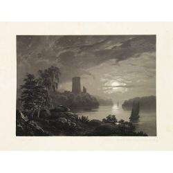
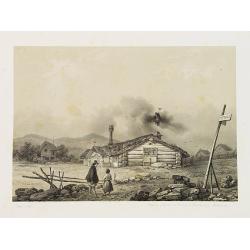
Stockholm, 2e vue en panorama, prise sur le Velar.
Lithography on tinted grounds. View of Stockholm. From "Voyage en Scandinavie, en Laponie, etc" - Atlas Pirtoresque (complément). Designed by A.Mayer and litho...
- $200 / ≈ €187
Place & Date: Paris, ca 1834-1838
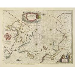
Regiones Sub Polo Arctico.
One of the many cases of duplication by the firms of Blaeu and Hondius/Jansson. In this case, Blaeu has copied Janssonius's map of 1637. It depicts rhumb lines radiating ...
- $1350 / ≈ €1263
Place & Date: Amsterdam, 1640
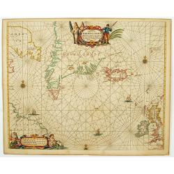
Pascaerte van Groen-Landt, Yslandt, Straet Davids en Ian Mayen eylandt. . .
An eye-catching chart of the North Atlantic, showing prominent Greenland, Iceland, and parts of the North American continent. The map is decorated with a large figurative...
- $2000 / ≈ €1871
Place & Date: Amsterdam, 1666
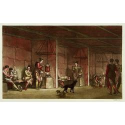
Intérieur d'une maison groënlandaise.
This aquatint engraved plate was color printed on fine move paper of a soft aged white color, bearing the embossed seal of authenticity impressed at the time of publicati...
- $75 / ≈ €70
Place & Date: Milan 1827
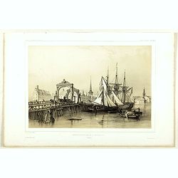
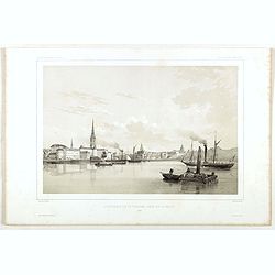
Pont de Knippelsbroe a Copenhague.
View of Knippelsbroe's bridge in Copenhagen. From "Voyage en Scandinavie, en Laponie, etc" - Atlas Pirtoresque (complément). Designed by A.Mayer.
- $150 / ≈ €140
Place & Date: Paris, ca 1834-1838
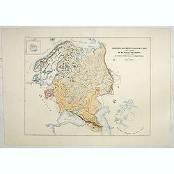
Circoscrizione delle Province ecclesiastiche e Diocesi nelle Impero di Russia in Europa vicariato aplico di Svezia Norvegia e prefettura del Polo Artico (Tav XC)
A large-format map of Sweden, Norway, Russia with its different dioceses. Inset map of Iceland and a North Pole projection. The map is finely engraved and beautifully col...
- $550 / ≈ €515
Place & Date: Rome, 1858
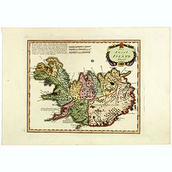
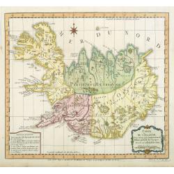
Die Insel Island Nro. 76.
An attractive map of Iceland based on the unpublished Knoff survey. The map locates villages and churches and graphically delineates the mountains, rivers, lakes and fore...
- $600 / ≈ €561
Place & Date: Vienna, 1789
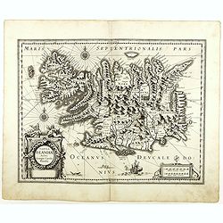
Tabula Islandiae..
This handsome map of Iceland was based on information from a Dutch navigator named Joris Carolus in about 1620. The map shows the influence of both versions of bishop Gud...
- $1100 / ≈ €1029
Place & Date: Amsterdam, 1645
Regni Sueciae in omnes suas Subjacentes Provincias accurate divisi Tabula Generalis. . .
Johann Baptist Homann's well-engraved map has a large decorative cartouche. Detailed map of Scandinavia, the Baltic Sea, Lithuania, Latvia, Estonia, Curlandia, etc.Johann...
- $300 / ≈ €281
Place & Date: Nuremberg, 1747
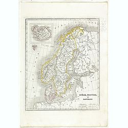
Suède, Norvège et Danemark.
Detailed map of Sweden, Norway and Denmark, prepared by Charles V. Monin (fl.1830-1880) a French cartographer of Caen and Paris. Published in Atlas Universel de Géograph...
- $35 / ≈ €33
Place & Date: Paris, 1845
Insula Islandiae delineatio. . .
A nice large map of Iceland published by Homann Heirs. The country is divided up into four differently colored regions, lettered title to top of map, boxed mileage scales...
- $900 / ≈ €842
Place & Date: Nuremberg, 1761
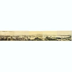
Panorama de Stockholm, Pris de la Coupole de L'Eglise de Skeppsholmen (5 sheets)
Panorama of Stockholm, with numerous captions describing buildings, showing the city as it was in the mid-19th century. On five sheets not joined, total 283 x 2175 mm, fr...
- $400 / ≈ €374
Place & Date: Paris, 1830
L'Isola d'Islanda divisa Ne Suoi Distretti Di nuova Projezione.
A finely engraved map of Iceland, with a decorative title cartouche to the bottom right hand corner illustrating a rural scene. Published in Zatta's "Atlante Novissi...
- $500 / ≈ €468
Place & Date: Venise, 1781
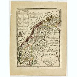
Le Royaume de Norwege Divisé en ses cinq Principaux Gouvernements. . .
Lovely small map of Norway, with much of Sweden to the East, vessel and sea monsters in the Norwegian Sea.It shows a text table in the upper left corner containing the na...
- $100 / ≈ €94
Place & Date: Paris, 1719
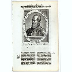
Fredericus II. D. G. Daniae Et Norvegiae Rex. Dux Holsatiae etc.
The engraving depicts a half length oval portrait of "Fredericus II".Nicolaes de Clerck (de Klerc) was active as engraver and publisher in Delft from 1599-1621....
- $20 / ≈ €19
Place & Date: Amsterdam, Cloppenburch, 1621
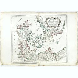
Royaume de Danemarck. qui comprend le Nort-Jutland . . . Sélande, Laland.
Finely and crisply engraved map of Denmark. Venetian edition of Giles Didier Robert De Vaugondy's map from Atlas Universel printed in 1776-84. Ornamental title cartouche ...
- $100 / ≈ €94
Place & Date: Venice, 1776 - 1784
Fridericus I. D. G. Daniae Et Norvegiae Rex. etc.
The engraving depicts a half length oval portrait of "Fridericus I".Nicolaes de Clerck (de Klerc) was active as engraver and publisher in Delft from 1599-1621.I...
- $20 / ≈ €19
Place & Date: Amsterdam, Cloppenburch, 1621
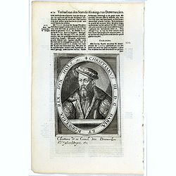
Christianus III. D. G. Daniae Et Norwegiae Rex. Dux Hols. etc.
The engraving depicts a half length oval portrait of "Christianus III".Nicolaes de Clerck (de Klerc) was active as engraver and publisher in Delft from 1599-162...
- $20 / ≈ €19
Place & Date: Amsterdam, Cloppenburch, 1621
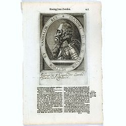
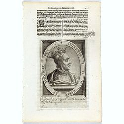
Ioannes II. D.G. Svecior. Gotthor. et Vandalor. Rex.
The engraving depicts a half length oval portrait of "Ioannes II".Nicolaes de Clerck (de Klerc) was active as engraver and publisher in Delft from 1599-1621.Inc...
- $15 / ≈ €14
Place & Date: Amsterdam, Cloppenburch, 1621