Browse Listings in Europe > Russia / Baltic / Black Sea region > Estonia / Latvia / Lithuania
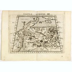
Tabula Europae IIII.
The scarce FIRST edition of this classical map depicting Northern Europe, Denmark and the Baltic. Includes engravings of a number of interesting animals in the right-hand...
- $450 / ≈ €421
Place & Date: Venice, 1561
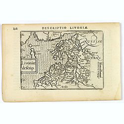
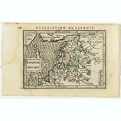
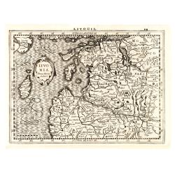
Livoniae descrip.
An attractive miniature map of the Baltic region of Livonia, as it was at the beginning of the seventeenth century, and published by Petrus Bertius in Amsterdam. The map ...
Place & Date: Amsterdam, 1606
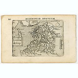
Descriptio Borussiae / Livoniae descrip.
A rare miniature map of Livonia. Title cartouche on the lower left corner.First published in 1598 in his Caert-Thresoor, the plates were executed by the most famous engra...
- $350 / ≈ €328
Place & Date: Amsterdam, Cornelis Claes, 1606
Livonia.
Scarce miniature map of Lithuania, from the first French-text edition of Jodocus Hondius' Atlas Minor. Engraved by Pieter Van Den Keere.Shortly after the publication of t...
- $300 / ≈ €281
Place & Date: Amsterdam, Cloppenburgh, 1608
Livoniae Descrip.
A rare miniature map of the Baltic States Estonia, Latvia & Lithuania. The present map is one of the earliest obtainable maps to focus this region. Title cartouche o...
- $200 / ≈ €187
Place & Date: Amsterdam, 1618
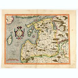
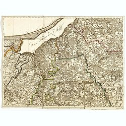
Livonia. 1627
Detailed map of the northern Baltic region. The map is centered on Riga and extends south to Memel, west to Poland and part of Russia and north to the Strait between Finl...
- $500 / ≈ €468
Place & Date: Amsterdam, ca. 1630
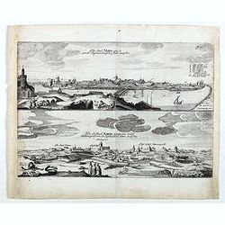
Die stadt Narva . . .
Two panoramic views of the city of Narva, on one sheet. Narva is the third largest city in Estonia. It is located at the eastern extreme point of Estonia, at the Russian...
- $250 / ≈ €234
Place & Date: Schleßwig, Zur Glocken, 1647
La Livonie duché divisée en ses princip. parties Esten & Letten & c. / par le Sr. Sanson. . .
Fine map of the Baltic Coast from Riga to the Gulf of Finland, with the islands of Saaramaa and Hiiumaa off the coast of Estonia. Title cartouche in lower left corner and...
Place & Date: Paris, 1663
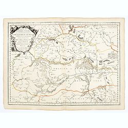
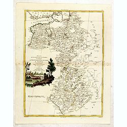
Partie de Lithuanie ou est en partie le Palatinat de Nowogrodeck Litawiski, subdivisé en leurs Chastellenies , le Palatinat de Bressici en Polesie, avec les duchés de Neswies, et Slusck, et partie du Palatinat de Minsk.
Scarce regional map, centered on Pinsk and showing Polish Lithuania, including part of modern Poland, Belarus, etc. This edition carries the date 1665. Nicolas Sanson was...
Place & Date: Paris, 1665
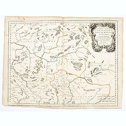
Partie de Lithuanie où sont les palatinats de Poloczk, Witepsk, Mseislaw, et partie de Minsk avec le duché de Smolensko.
Scarce and fine map of Belarus, including Smolensko in Russia and the region northeast of Minsk. This edition carries the date 1665 and the publishers address "A Par...
Place & Date: Paris, 1665
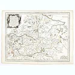
Partie de Lithuanie ou sont en partie les Palatinats de Wilna, et Troki, subdivisés en leurs Chastellenies et partie du Palatinat de Minsk.
Fine map of Lithuania. This edition carries the date 1665 and the publishers address "A Paris, chez Pierre Mariette, rue Saint Jacques a l'Esperance…"Nicolas ...
Place & Date: Paris, 1666
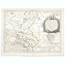
Partie de Lithuanie ou sont en partie les Palatinats de Minsk, et Mseislaw, we les Seign.Ries ou Terres de Rohaczow, Rzeczica, Zernobee, et partie des. . .
Fine map of Lithuania. This edition carries the publishers address "chez l'Autheur Avec privilege pour vingt ans 1666". Nicolas Sanson was to bring about the ri...
Place & Date: Paris, 1666
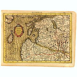
Livonia.
Finely engraved map of the Baltic states Estonia and Latvia filled with forests, rivers and lakes. French text on verso. Engraved by Petrus Kaerius for Janssonius' pocket...
- $250 / ≈ €234
Place & Date: Amsterdam, Jan Cloppenburgh, 1673
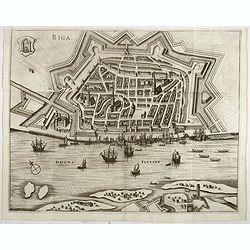
Riga.
Decorative view of Riga. This well executed engraving was published in 1729 and 1727 by Pieter van der AA, in Leiden in "Les Voyages tres-curieux et tres-renommez fa...
- $600 / ≈ €561
Place & Date: Leiden, 1719
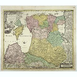
Ducatuum Livoniae et Curlandiae cum vicinis Insulis Nova Exhibitio Geographica. . .
Detailed map of the northern Baltic coast by Homann, pre-dating the privilege.
- $450 / ≈ €421
Place & Date: Nüremberg, 1720

Riga metropolis Livoniae.
A spectacular panoramic of Riga, with legends numbered from a-z and 1-16 in German. With the title in a banderol.After a design by Friedrich Bernhard Werner (1690-1776) ...
Place & Date: Augsburg, ca. 1720
Regnum Borussiae gloriosis auspicijs Seerenissimi et Potentissimi Princip Friderici III Primi . . .
Map covering the region along the Baltic Sea from Prussia, Memel, to northern Poland, extending south to Poland, centered on Danzig, Konigsberg, Heilsperg, etc. Beautiful...
- $350 / ≈ €328
Place & Date: Nuremberg, 1720
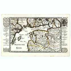
Der Nordischen Königreiche Süd=Oost Theil begreiffende Liefland Ingermanland und Finnland zum Theil.
Uncommon map published by Gabriel Bodenehr, who bought the Stridbeck copper plates in 1716, and continued publishing the Stridbeck Atlas: "Atlas Curieux," under...
- $400 / ≈ €374
Place & Date: Augsburg, 1730

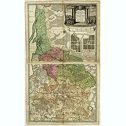
Potentissimo Borussorum Regi Friderico Wilhelmo Maiestate, Fortitudine Clementia Augustissimo Hancce Lithuaniam Borussicam : in qua luca coloniis Salisburg., ad incolendum Regio nutu...
Potentissimo Borussorum Regi Friderico Wilhelmo Maiestate, Fortitudine Clementia Augustissimo Hancce Lithuaniam Borussicam : in qua luca coloniis Salisburg., ad incolendu...
Place & Date: Nuremberg, 1735
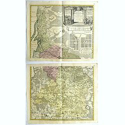
Potentissimo Borussorum Regi Friderico Wilhelmo Maiestate, Fortitudine Clementia Augustissimo Hancce Lithuaniam Borussicam : in qua luca coloniis Salisburg., ad incolendum Regio nutu concessa ...
Potentissimo Borussorum Regi Friderico Wilhelmo Maiestate, Fortitudine Clementia Augustissimo Hancce Lithuaniam Borussicam : in qua luca coloniis Salisburg., ad incolendu...
- $1500 / ≈ €1404
Place & Date: Nuremberg, 1735
Potentissimo Borussorum Regi Friderico Wilhelmo Maiestate, Fortitudine Clementia Augustissimo Hancce Lithuaniam Borussicam : in qua luca coloniis Salisburg., ad incolendum Regio nutu concessa ...
Potentissimo Borussorum Regi Friderico Wilhelmo Maiestate, Fortitudine Clementia Augustissimo Hancce Lithuaniam Borussicam : in qua luca coloniis Salisburg., ad incolendu...
- $1200 / ≈ €1123
Place & Date: Nuremberg, 1735
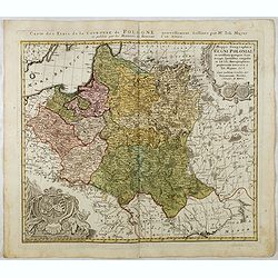
Mappa Geographica Regni Poloniae ex novissimis quotquot sunt mappis specialibus composita et al L.L. Stereographicae projectionis revocata a Tob. Mayero. . . .
Decorative map of Poland after Tobias Mayer who was based on Barnikel's map of Curland (1747) and Jan Nieprzecki's map of Lithuania (1749).Poland extends from Glogau and ...
- $600 / ≈ €561
Place & Date: Nuremberg, 1757
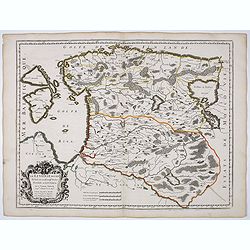
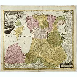
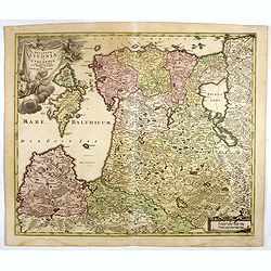
Dvcatvvm Livoniae et Cvrlandiae cum vicinis insulis nova exhibitio geographica.
A very attractive of Livonia, Estonia, Curlandia and the Baltic coast, which also includes the Gulf of Livonia or Riga.
- $450 / ≈ €421
Place & Date: Nuremberg, 1760
Dvcatvvm Livoniae et Cvrlandiae cum vicinis insulis nova exhibitio geographica.
A very attractive of Livonia, Estonia, Curlandia and the Baltic coast, which also includes the Gulf of Livonia or Riga.
- $500 / ≈ €468
Place & Date: Nuremberg, 1760
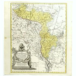
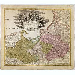
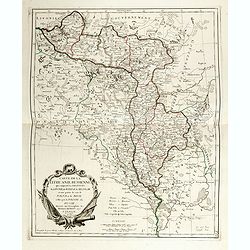
Charte von Russisch Litauen, welche die von Polen an Russland Abgetretene Woiewodschaften, Liefland, Witepsk, Mscislaw, und einem Theil der Woiewodschaften Polock und Minsk Enthalt.
An uncommon map of Belarus, together with parts of the Ukraine and Lithuania. Shows the rivers Dnieper and Dwiner from Liefland to Mscislaw and Woiwodschaft.. With the to...
- $500 / ≈ €468
Place & Date: Nuremberg, 1775
Tabula Regni Borussiae, Borussiam Orientalem exhibens . . .
Kingdom of Prussia, today part of the territory of the Polish, Lithuanian and Russian.
- $900 / ≈ €842
Place & Date: Augsburg, 1775
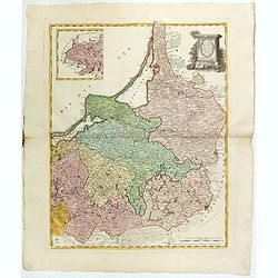
Carte de la Lithuanie Prussienne qui comprend les Palatinats de Livonie, de Witepsk, de Liscislaw, et une partie de ceux de Polock et de Minsk cédés par la Pologne à la Russie. Dressée sur l'Exemplaire des Héritiers Homann 1775.
Detailed map of the areas along the river Dnieper and Duna. Santini gives credit to Homann Heirs in the cartouche.The map was prepared by the Venetian cartographer and pu...
- $300 / ≈ €281
Place & Date: Venice, 1776
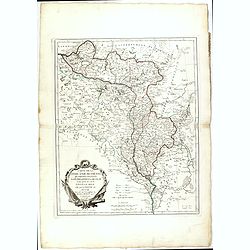
Ducati di Livonia e di Estonia, e Governi di Nowogorod...
Shows today's Estonia, and the governorates Nowgorod, Bialgorod and Kiew in today's Russia, Belarus and Ukraine.
- $175 / ≈ €164
Place & Date: Venise, 1782
Carte de la Lithuanie Russienne qui comprend les Palatinats de Livonie, de Witepsk, de Miscislaw, et une partie de ceux de Polock et de Minsk cédés par la Pologne à la Russie. Dressée sur l'Exemplaire des Héritiers Homann 1775.
Detailed map of the areas along the river Dnieper and Duna. Santini gives credit to Homann Heirs in the cartouche. The map was prepared by the Venetian cartographer and p...
- $500 / ≈ €468
Place & Date: Venice, 1776 - 1784
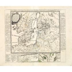
Neue Karte von den gegenwärtigen Kriegs-Schauplatze zwischen den Russisch-Kayserl.
Very rare separately published map showing the Russian War seat including Finland, Lithuania, Denmark and parts of Poland, Norway and Sweden. In lower part inset maps of ...
Place & Date: Leipzig, 1788
Selling price: $2100
Sold in 2013

A plat of the East Sea. By William Fisher and Richard Mount...
An important sea chart of the East Sea with coast lines of Poland, Russia, Sweden, published by William Fisher and Richard Mount in London.Richard Mount (1654-1722) was a...
- $1800 / ≈ €1684
Place & Date: London, 1795
(Sheet X with Puk Bay from) General Tableau zur Karte von Alt Ost und West Preussen nebst dem aufgenommenen Trigonometrischen Netz. . .
Sheet IV with Zalew Wislany and the towns of Elblag, Paslek, Braniewo, etc of this important multi sheet map of Prussia, Lithuania and Poland.The rare first edition of th...
Place & Date: Berlin, 1802-1810
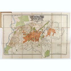
Cesu un apkartnes vadonis ar Cesu pilsetas planu. . .
Uncommon and detailed plan of Cesis and its direct surroundings. Cesis is a town in northeastern Latvia, built in the 13th century and one of the best-preserved medieval ...
- $550 / ≈ €515
Place & Date: Cesu, 1928