Browse Listings in Europe > Russia / Baltic / Black Sea region
![Femme Samoïede [together with] Homme Samoïede.](/uploads/cache/36923-250x250.jpg)
Femme Samoïede [together with] Homme Samoïede.
Set of two originally hand-colored mezzotints of Native Russians engraved by Félix Mixelle and Lachaussée Jeune after Jacques Grasset de Saint-Sauveur.As an etcher, dra...
- $50 / ≈ €47
Place & Date: Paris,1801-1806
![Fille Barabinze [together with] Homme Barabinze.](/uploads/cache/36931-250x250.jpg)
Fille Barabinze [together with] Homme Barabinze.
Set of two originally hand-colored mezzotints of Native Russians engraved by Félix Mixelle and Lachaussée Jeune after Jacques Grasset de Saint-Sauveur.As an etcher, dra...
- $50 / ≈ €47
Place & Date: Paris,1801-1806
![Homme Morwine [together with] Femme Mordwine.](/uploads/cache/36920-250x250.jpg)
Homme Morwine [together with] Femme Mordwine.
Set of two originally hand-colored mezzotints of Native Russians engraved by Félix Mixelle and Lachaussée Jeune after Jacques Grasset de Saint-Sauveur.As an etcher, dra...
- $50 / ≈ €47
Place & Date: Paris,1801-1806
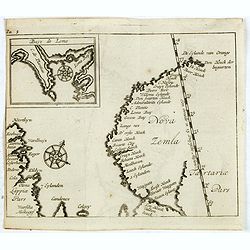
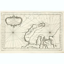
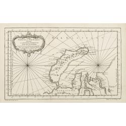
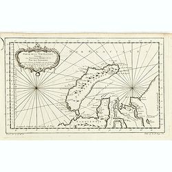
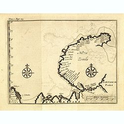
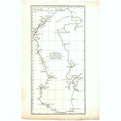
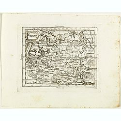
(Map of Nova Zembla with inset of Baye de Loms.)
Map of Nova Zembla with inset of Baye de Loms (5x7mm.). From the French reissue of the account of early Dutch voyages first published in 1608 by Commelin. The French tran...
- $110 / ≈ €103
Place & Date: Amsterdam, E. Roger, 1702
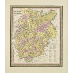
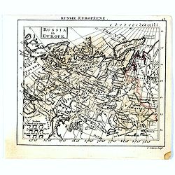
Russia in Europe.
From S. Augustus Mitchell’s "A New Universal Atlas". Philadelphia. Lithographic transfer from engraved plate. A fine map of Russia in Europe from the mid-nine...
- $80 / ≈ €75
Place & Date: Philadelphia, c.1846
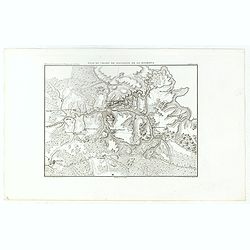
Plan du Champ de Bataille de la Moskowa
Prepared by Thunot Duvotenay (1796-1875), a French geographer and publisher. Detailed map taken from: "Thiers, Atlas de l' Histoire du Consulat et de l' Empire"...
- $150 / ≈ €140
Place & Date: Paris, 1850
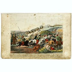
Gefecht bei Daoughelichki, den July 1812.
Rare German print showing the siege of Daoughelichki, July 1812, during the French Russian Campaign, which ended in Napoleon's defeat.
- $150 / ≈ €140
Place & Date: Nuremberg, ca. 1815
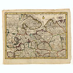
'T Noorderdeel van Moscovie Na de stelling van G. de L'Isle. . .
Attractive and rare map of part of Russia, including St. Persburg, Archangel, Finland, Lapland and Moscow. From Atlas Portatif .
- $100 / ≈ €94
Place & Date: Deventer, 1742
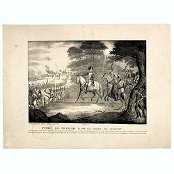
Entrée des Français dans la ville de Moscou . . .
View of the French's army entering Moscow on 14 September 1812 during the Napoleonic Wars (1800-1815) in Russia.
- $75 / ≈ €70
Place & Date: Brussels, ca. 1812

Les Rivieres Kur, et Aras.
View of Aras rivers after Cornelis de Bruyn, from "'Voyages de Corneille le Brun par la Moscovie, en Perse et aux Indes Orientales ...', by Corneille le Brun (Cornel...
- $75 / ≈ €70
Place & Date: Amsterdam, Wetstein, 1718
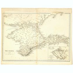
The Crimea.
Map of Crimea and the Sea of Azov. In lower right corner inset map showing Sebastopol region.
- $50 / ≈ €47
Place & Date: London, 1854
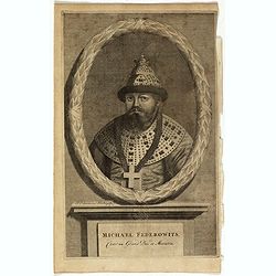
Michael Federowits . . .
Portrait of Tsar Michail Feodorovich (1596-1645). Engraving by Jacob Christopher Sartorius (1694-1737) engraver, active in Nuremberg. This well executed engraving was pub...
- $75 / ≈ €70
Place & Date: Leiden, 1719
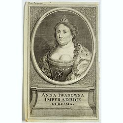
Anna Iwanowna Imperadrice di Russia.
Portrait of Anna Iwanowna (1693 – 1740), was regent of the duchy of Courland from 1711 until 1730 and then ruled as Empress of Russia from 1730 to 1740.
- $75 / ≈ €70
Place & Date: France, ca. 1730
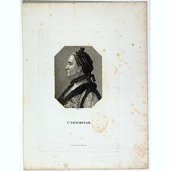
Catharina II.
Portrait of Catharina II (1729-1796) or Catherine the Great, Empress of Russia. During the reign of the flamboyant and powerful Empress Catherine II of Russia, whose long...
- $60 / ≈ €56
Place & Date: Germany, ca. 1820
Partie De La Mer Glaciale Contenant La Nouvelle Zemble et Le Pais Des Samoiedes . . . 1758
Detailed map of Nova Zembla and part of the Northeast passage.From Prevost's l'Histoire générale des voyages , the map prepared by J.N. Bellin. Jacques Nicolas Bellin (...
- $60 / ≈ €56
Place & Date: Paris, 1758
![[Schwarzes Meer] Nr 1](/uploads/cache/37946-250x250.jpg)
[Schwarzes Meer] Nr 1
Uncommon map of the Black Sea and Crimea. In lower part a scale. Prepared by Friedrich Handtke (1815-1879). Map set in a decorative border.
- $120 / ≈ €112
Place & Date: Glogau, Leipzig, 1877
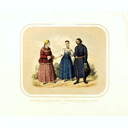
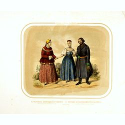
Race Finnoise. = Paysans du gouvernement d'Olonetz districts de Petrozavodsk et de Vytiagorsk.
People in local dress from Petrozavodsk region in Russia. Lithography on tinted grounds printed by Lemercier in Paris and published by Velten in St. Petersburg.
- $150 / ≈ €140
Place & Date: Paris, St. Petersburg, Carlsruhe, c.1860

Kamchatka according to A.Erman . . .
FIRST EDITION Map of the Kamchatka Peninsula, Siberia, from Gazetteer of the World. Drawn by Augustus Petermann, engraved by G. H. Swanston.
Place & Date: London / Edinburgh, 1850
(Die Fontanka beim kaiserlichen Garten in Petersbourg.)
Fontanka River at the Summer Garden in Saint Petersburg. Part of a set of 14 loose and individually mounted plates of views of St. Petersburg and Moscow, plus one plate o...
- $100 / ≈ €94
Place & Date: St. Peterdburg, 1806
Partie de la Mer Glaciale contenant de la nouvelle Zemble..
A good engraved map of Nova Zembla. The geographical features are typical with somewhat exaggerated bays and inlets. From l'Histoire générale des voyages .
- $80 / ≈ €75
Place & Date: Paris, 1758
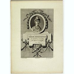
Fédor Borissovitz il succéda a son père, fut détroné et étouffé en 1505.
Portrait of Fédor Borissovitz. (1589 - 1605), engraved by Louis Pauquet (1759-1824).
- $75 / ≈ €70
Place & Date: Paris,1814
Race Finnoise. Paysans du gouvernement d'Olonetz districts de Petrozavodsk et de Vytiagorsk.
Lithography on tinted grounds printed by Lemercier in Paris and published by Velten in St. Petersburg.
- $100 / ≈ €94
Place & Date: Paris, St. Petersburg, Carlsruhe, c.1860
![[Costumes des Karabulaks - Caucase]](/uploads/cache/62344-250x250.jpg)
[Costumes des Karabulaks - Caucase]
Four men from the Caucasus in typical dress from the Karabulaks tribe. Plate N° 15. from Giulio Ferrario's work "Le Costume Ancien et Moderne ou Histoire du gouvern...
Place & Date: Milan, 1827
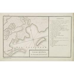
Cours de l'Iaik au dessous de Gourief.
Engraved map of the estuary of the river Ural south of Gurjev. Map from a second French edition of Peter Simon Pallas' Voyages du Professeur Pallas, dans Plusieurs Provin...
Place & Date: Paris, Maradan, 1794
Selling price: $60
Sold in 2010
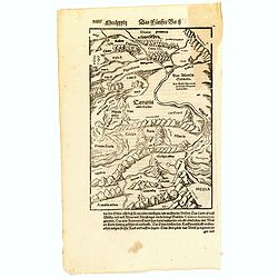
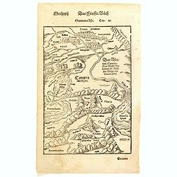
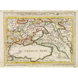
(Central Europe)
Map showing the region between the Black Sea and the Caspian Sea with parts of Tartary and Kazakhstan, also the neighboring Armenia in the south.From a German text editio...
- $80 / ≈ €75
Place & Date: Basle, 1550-1590
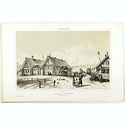
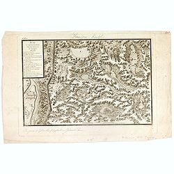
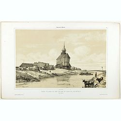
Village de Goumnisthe entre Kostroma et Yaroslaw..
A view of Goumnisthe village. Figures are lithographed by Raffet. Plate taken from the first illustrated account of Russian architecture. This publication was the project...
Place & Date: Paris, 1844
Partie De La Mer Glaciale Contenant La Nouvelle Zemble et Le Pais Des Samoiedes . . . 1758
Detailed map of Nova Zembla and part of the Northeast passage.From Prevost's l'Histoire générale des voyages , the map prepared by J.N. Bellin. Jacques Nicolas Bellin (...
- $50 / ≈ €47
Place & Date: Paris, 1758
Russia in Europe.
Uncommon miniature map of Russia, engraved by Thomas Kitching for "A New General and Universal Atlas Containing Forty five Maps by Andrew Dury".This miniature a...
- $75 / ≈ €70
Place & Date: London, 1761-1763
Sarmatia Asie.
The map is showing the area of Armenia and Kazakhstan. From his Cosmographia, that great compendium of Renaissance knowledge. Sebastian Münster was born in Nierder-Ingel...
- $90 / ≈ €84
Place & Date: Basle, 1550-1580
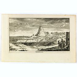
Derbent.
View of Derbent, the southernmost city in Russia from a scarce series of city views by Daniel de la Feuille (1640-1709). Engraving shows the ancient fortress and ruins of...
- $100 / ≈ €94
Place & Date: Amsterdam, 1734
(Map of Nova Zembla with inset of Baye de Loms.)
Map of Nova Zembla with inset of Baye de Loms (5x7mm.).From the French reissue of the account of early Dutch voyages first published in 1608 by Commelin. The French trans...
- $100 / ≈ €94
Place & Date: Amsterdam, F. Bernard, 1725
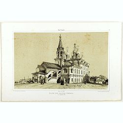
Eglise des saintes femmes.
A view of a church, the 5 of September 1839. Figures are lithographed by Raffet. Plate taken from the first illustrated account of Russian architecture. This publication ...
Place & Date: Paris, 1844
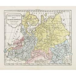
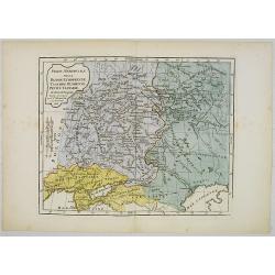
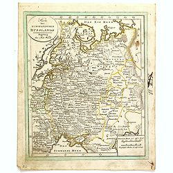
Partie Septentrionale de la Russie Européenne . . .
Detailed map of European part of Russia, including Finland and Lapland.
Place & Date: Paris, 1780
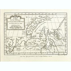
Carte des Païs habités par les Samojedes et Ostiacs, pour l'histoire générale des voyages.
Map shows Nova Zembla and the area of northern Russia that was inhabited by the Samoyeds and Ostiacs.Prepared by Jacques Nicolas Bellin after Dutch sources and included i...
- $75 / ≈ €70
Place & Date: Paris, 1760
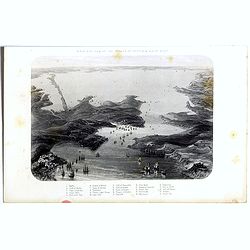
Birds-eye view of the Straits of Kertch & Sea of Azoff.
Steel engraving of the harbour at Sebastopol and the Straits of Kertch and Sea of Azoff in the Ukraine published by James Virtue around 1860.Title in upper margin. With a...
- $75 / ≈ €70
Place & Date: London, 1870
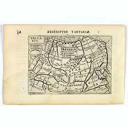
Tartaria.
A fine miniature map showing China, Korea and Russia. Title cartouche on the upper left corner. First published in 1598 in his Caert-Thresoor, the plates were executed by...
- $100 / ≈ €94
Place & Date: Amsterdam, 1606
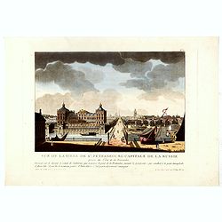
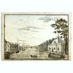
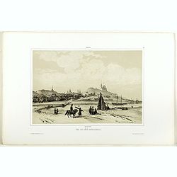
Vue de la ville de St. Pétersbourg capitale de la russie prise du côté de la Fontanka . . .
This aquatint print figures the town of St. Peterburg. With address "A Paris chez le Coeur graveur, rue Mouffetard, N° 89 et chez Bance aîné, rue Saint Denis, N°...
- $100 / ≈ €94
Place & Date: Paris, Le Cœur et Bance ainé, ca 1814
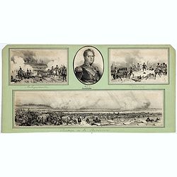
Passage de la Berezinas.
Set of four views of The Battle of Berezina (or Beresina) which took place from 26 to 29 November 1812, between the French army of Napoleon, retreating after his invasion...
Place & Date: ca. 1812
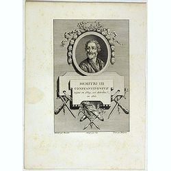
Demitri III Constantinovitz, regne en 1359, est detrône en 1361.
Portrait of Demitri III Constantinovitz., Grand Duke of Russia, engraved by C.-N. Malapeau.
- $75 / ≈ €70
Place & Date: Paris, 1814
Essai D'Une Nouvelle Carte de la Mer Caspienne.
Interesting map of the Caspian Sea between Russia and Iran. Jean Baptiste d'Anville (1697-1782) born in Paris was perhaps the most important and prolific cartographer of ...
- $80 / ≈ €75
Place & Date: Paris, 1754
Plan et coupe horisontale du labyrinte souterrain de Koungour Renvoi.
Engraved map of the Urals with the town Kungur in Russia. With a lettered key A-P in left corner. From the Atlas Volume of "Histoire physique, morale, civile et poli...
Place & Date: Paris, 1783
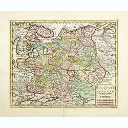
Nieuwe Kaart van Muskovie of Rusland.
Detailed map of European Russia, far south to the Black Sea and Caspian Sea. Isaac Tirion was born in Utrecht ca. 1705. He came to Amsterdam ca. 1725. Tirion published a ...
- $150 / ≈ €140
Place & Date: Amsterdam, 1734
Estats du Grand Duc de Moscovie . . .
An interesting small map of Moscovie by Nicolas de Fer. From his rare "Petit et Nouveau Atlas". The first edition was published in 1697 and was republished in 1...
- $200 / ≈ €187
Place & Date: Paris, 1697
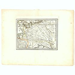
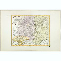
Partie Méridionale de la Russie Européenne, Tartarie, Russienne, Petite Tartarie.
Map of the southern part of Russia and Tartary. By C. F. Delamarche, successor of Robert de Vaugondy, Geographer.
- $90 / ≈ €84
Place & Date: Paris, 1806
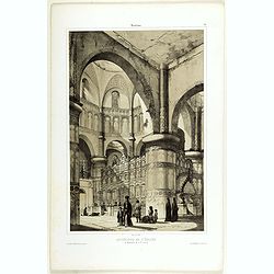
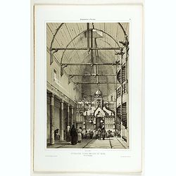
Intérieur de l'église du Monastère de la Ste Trinité.
A view of the Ste Trinity Monastery. Figures are lithographed by Raffet. Plate taken from the first illustrated account of Russian architecture. This publication was the ...
- $100 / ≈ €94
Place & Date: Paris, 1844
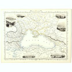
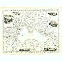
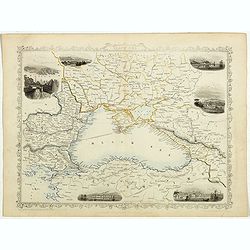
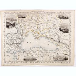
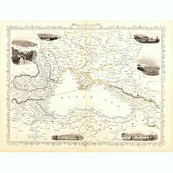
Black Sea.
Decorative steel engraved map of the Black Sea with inset views of Sebastopol and Odessa. There are also vignettes of Constantinople, Sinope and Varna. Taken from "T...
- $90 / ≈ €84
Place & Date: London, London Printing and publishing Company of London, ca. 1851
Partie Méridionale de la Russie Européenne, Tartarie, Russienne, Petite Tartarie.
Map of the southern part of Russia and Tartary. The Caspian Sea in lower right corner. By C. F. Delamarche, successor of Robert de Vaugondy, Geographer.
- $50 / ≈ €47
Place & Date: Paris, 1806
Karte des Europaeischen Russland. . ..
Nice small map of Russia.
- $100 / ≈ €94
Place & Date: Augsburg, 1820
Partie Méridionale de la Russie Européenne, Tartarie Russienne, Petite Tartarie.
Map of the southern part of Russia and Tartary. The Caspian Sea in lower right corner. By C. F. Delamarche, successor of Robert de Vaugondy, Geographer.
- $90 / ≈ €84
Place & Date: Paris, 1806
Black Sea.
Decorative steel engraved map of the Black Sea with inset views of Sebastopol and Odessa. There are also vignettes of Constantinople, Sinope and Varna. Taken from "T...
Place & Date: London, London Printing and publishing Company of London, ca. 1851
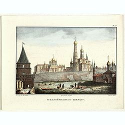
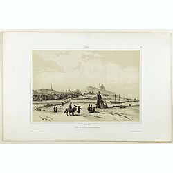
Vue du Kremlin à Moscou.
View of the Kremlin, lithographed by Brocas after a design by Edouard de Montulé. Lithography was printed by Langlumé in Paris. Taken from : Voyage en Angleterre et en ...
- $125 / ≈ €117
Place & Date: Paris, Arthus Bertrand, 1825

Black Sea.
Decorative steel engraved map of the Black Sea with inset views of Sebastopol and Odessa. There are also vignettes of Constantinople, Sinope and Varna. Taken from "T...
- $90 / ≈ €84
Place & Date: London, London Printing and publishing Company of London, ca. 1851
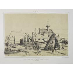
Village sur la route de Moscou. (9 Août 1839).
A view of a village on the way to Saint Petersburg on August 9 1839. Plate taken from the first illustrated account of Russian architecture. This publication was the proj...
Place & Date: Paris, 1842
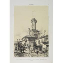
Tour d'Observation et siège de police dans la grande Morskoi. (2 Juillet 1839).
A view of Observation Tower and police headquarters in the Morskoi in Saint Petersburg on August 9 1839. Plate taken from the first illustrated account of Russian archite...
Place & Date: Paris, 1840
Selling price: $250
Sold in 2013
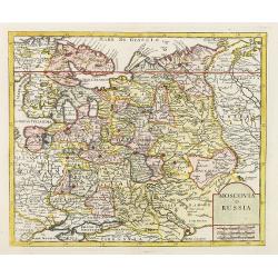
Moscovia.
Rare map of western Russia centered on Moscow, from "Atlante Novissimo ad uso Dei Giovani Studiosi Contenuto In Carte XXVII.", published by Giovanni Zempel in R...
- $100 / ≈ €94
Place & Date: Rome, 1780
Intérieur d'une église en bois, près de Kineschma.
A view of a church's inside, made of wood. Figures are lithographed by Raffet. Plate taken from the first illustrated account of Russian architecture. This publication wa...
- $100 / ≈ €94
Place & Date: Paris, 1844
Black Sea.
Decorative steel engraved map of the Black Sea with inset views of Sebastopol and Odessa. There are also vignettes of Constantinople, Sinope and Varna. Taken from "T...
Place & Date: London, London Printing and publishing Company of London, ca. 1851
Vue du côté méridional.
A view of an old village. Figures are lithographed by Raffet. Plate taken from the first illustrated account of Russian architecture. This publication was the project of ...
- $150 / ≈ €140
Place & Date: Paris, 1844

Ajustement des Femmes de Valday Situé entre Petersbourg et Moscou.
Etching by Jean-Baptiste Le Prince (1734-1781), from "2me Suite de divers cris de marchands de Russie", showing typical russian customs. The sketches Le Prince ...
- $110 / ≈ €103
Place & Date: Paris, 1764
Black Sea.
Decorative steel engraved map of the Black Sea with inset views of Sebastopol and Odessa. There are also vignettes of Constantinople, Sinope and Varna. Taken from "T...
- $90 / ≈ €84
Place & Date: London, London Printing and publishing Company of London, ca. 1851
Assoph, Asow, oder Azak mit der Kleinen Tartarey dem Scwharzen Meer. . .
Scarce map showing the Black Sea region with Southern Ukraine, Georgia and Armenia.
- $100 / ≈ €94
Place & Date: Augsburg, 1715
Moscovia o Russia.
Map showing European Russia and is centered on Moscow. In the lower right corner, title cartouche with scale and the town of Astrakhan. From "Atlante Novissimo Che C...
Place & Date: Venice, 1740
Vieux village et son église en bois du XIIIe siècle près de Rostow.
A view of an old village and its church. Figures are lithographed by Raffet. Plate taken from the first illustrated account of Russian architecture. This publication wa...
- $100 / ≈ €94
Place & Date: Paris, 1844
Nikolskoï paroisse entre les villes de Soudogda et Mouroum.
A view of an old church. Figures are lithographed by Raffet. Plate taken from the first illustrated account of Russian architecture. This publication was the project of C...
- $150 / ≈ €140
Place & Date: Paris, 1844
Russie blanche ou Moscovie.
Map of the European part of Russia centered on Moscow and prepared by N.Sanson. Published in an early edition of the small Sanson atlas L'Europe Dediée a Monseigneur . ....
- $100 / ≈ €94
Place & Date: Amsterdam, ca. 1660
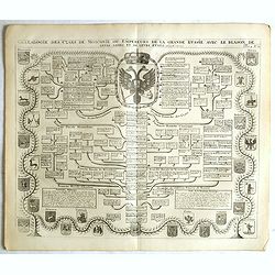
Généalogie des Cazrs de Moscovie ou empereurs de la grande Russie . . .
Genealogical tree, showing the lineage of the Russian Czar's, dating back to 840 according to Hubner. Published by Henri Abraham Chatelain (1684 – 1743) a Huguenot past...
- $250 / ≈ €234
Place & Date: Amsterdam, 1728
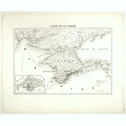
Carte de la Crimée.
Attractive map of Crimea with inset plan of Sevastopol, prepared by Alexandre Aimé Vuillemin (1812-1886). A road system and the ferry lines are drawn in.Engraved by Jaco...
- $150 / ≈ €140
Place & Date: Paris, ca. 1850
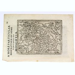
A More Particular Description of some Provinces of Moscovia.
From the English edition of the popular Mercator - Hondius atlas. English text to verso. This map elegantly depicts the Muscovy region of western Russia, with Moscow in t...
- $225 / ≈ €211
Place & Date: Amsterdam, 1630
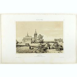
Vue de côté merodional.
A view of the village Vladimir. Figures are lithographed by Raffet. Plate taken from the first illustrated account of Russian architecture. This publication was the proje...
- $150 / ≈ €140
Place & Date: Paris, 1844
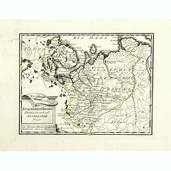
Des Russischen Reiches Statthalterschaft Archangel Nro.66
Map of the North Western part of Russia. Published by Franz Johann Joseph von Reilly, 1766-1820, who was a Viennese art dealer who turned to map publishing in his early t...
- $150 / ≈ €140
Place & Date: Vienna, 1789
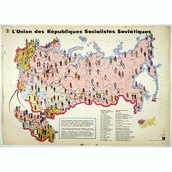
L'Union des Républiques socialistes Soviétiques. (2)
Map of Russia. Propaganda poster showing Russia' s population. With a key. Text in French. Editions de l'Agence de presse Novosti".More about War Maps & Propagan...
- $100 / ≈ €94
Place & Date: USSR, 1978
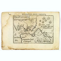
Descriptio Freti Vaigats.
Finely engraved map of the Vaigach Straits, from Bertius's rare miniature atlas. The map focuses on the straits between Novaya Zemlya and the Russian mainland, which had ...
- $150 / ≈ €140
Place & Date: Amsterdam, 1606
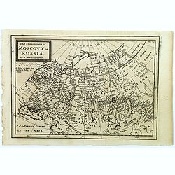
The Dominions of Moscovy or Russia.
A far reaching copperplate map of Russia by the Dutch emigrant Herman Moll. The map extends from Sweden in the west to Tartary and China in the east, to the south both th...
- $110 / ≈ €103
Place & Date: London, 1711
Black Sea.
Decorative steel engraved map of the Black Sea with inset views of Sebastopol and Odessa. There are also vignettes of Constantinople, Sinope and Varna. Taken from "T...
- $110 / ≈ €103
Place & Date: London, London Printing and publishing Company of London, ca. 1851
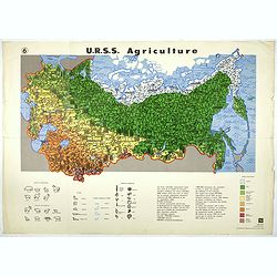
U.R.S.S. Agriculture. (6)
Map of Russia. Propaganda poster for Russia's in and export of industrial goods. With a key in bottom. Text in French. Editions de l'Agence de presse Novosti".More a...
- $100 / ≈ €94
Place & Date: USSR, 1978
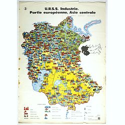
U.R.S.S. Industrie. Partie européenne, Asie centrale. (3)
Map of Eastern Russia. Propaganda poster for Russia's industry. Text in French. Editions de l'Agence de presse Novosti".More about War Maps & Propaganda maps [+]
- $100 / ≈ €94
Place & Date: USSR, 1978
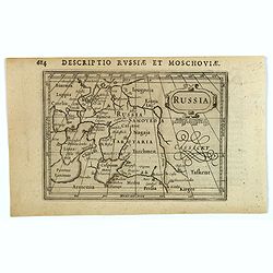
Russia.
Centered on Moscow, with the southern reaches of the map showing Persia, Armenia and Tashkent, the Black and Caspian Seas, and northward to Lapland and the frozen arctic ...
- $200 / ≈ €187
Place & Date: Amsterdam, 1616
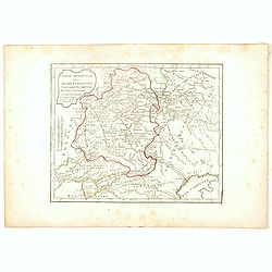
Partie Septentrionale de la Russie Européenne . . .
Detailed map of European part of Russia, including Finland, Lapland.
- $100 / ≈ €94
Place & Date: Paris, 1753
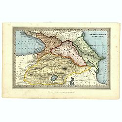
Armenia major, Iberia etc. by J.Archer.
Early Missionary map of Armenia from the "Atlas of educational maps for the use of schoolmasters" (1847), published by SPCK - the Society for Promoting Christia...
- $150 / ≈ €140
Place & Date: London, 1847
Von dem Moscowycern
Map centered on Moscow, with on verso a wood cut engraving of a Bison. From a German text edition of his Geographia , that great compendium of Renaissance knowledge.
- $125 / ≈ €117
Place & Date: Basle, 1550-1590