
Mapa Polski i Krajów Osciennych - Wydanie trzecie. Opracowal Stanislaw Max. Wydani M. Arcta.
‘The Birth of Modern Poland on a map’ - an excellent wall map of Poland and surrounding regions, published in Warsaw near the end of World War I, when Poland’s fate...
- $1000 / ≈ €936
Place & Date: Warsaw, [H. Sklodowski], 1918
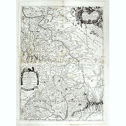
Il Ducato di Silesia et il Marchesato di Moravia
Scarce two-sheet map of the region along the River Oder in Poland, including parts of Chez Republic and Hungary. Excellent detail throughout. Large and decorative title a...
- $1200 / ≈ €1123
Place & Date: Rome, 1692

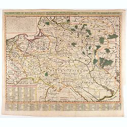
Grande Pologne et Prusse avec les frontières de la Misnie, Lusace, Moravie et Lithuanie.
Detailed map of Poland and Prussia. Published by Pieter van der Aa who published a.o. "Naauwkeurge versameling der gedenkwaardigste zee- en land-reysen", a seri...
Place & Date: Leiden, 1729
![Bataille de Pultusk, le 26 Decembre 1806. [manuscript map]](/uploads/cache/38810-250x250.jpg)
Bataille de Pultusk, le 26 Decembre 1806. [manuscript map]
Manuscript map of the siege of Pultusk (located on the west bank of the River Narew approximately 50 kilometres (31 mi) north of Warsaw), on 26 December 1806. With a colo...
- $1750 / ≈ €1638
Place & Date: Breda, 1849
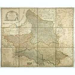
Nouvelle carte du royaume de Pologne, divisée selon..
Chatelain's map of Poland. The title is in two lines across the map. On bottom border appears an index to the map's contents. At the top of the map appear historical rema...
- $1100 / ≈ €1029
Place & Date: Amsterdam, 1719
Karte von Polen.
An attractive map of Poland. With a decorative title cartouche in the upper left-hand corner. Engraved by Ant. Amon. Franz Johann Josef von Reilly (Vienna 18 august 1766 ...
- $950 / ≈ €889
Place & Date: Vienna, 1796

Le Cours de l'Elbe et de l'Oder où sont les Electorats de Saxe et de Brandebourg, les Duchés de Mekelbourg et de Pomeranie. . .
A detailed and scarce map showing the rivers Elbe and Oder in Germany and Poland. Dark engraving.This is one sheet of the four sheet wall map by Pierre Du Val entitled: &...
Place & Date: Paris, 1684
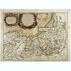
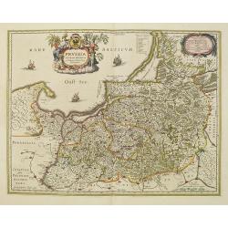
La Prussia Divisa in Reale Che Appartiene al Ré Di Polonia et in Ducale Che Spetta all'Elettore Di Brandeburgo. Da Giacomo Cantelli Da ...
In the upper left-hand corner a large title cartouche with a dedication to Cardinal Denhoff. The map is dated 1689.The cartographer was Giacomo Cantelli (1643-1695) who w...
- $1000 / ≈ €936
Place & Date: Rome, 1689
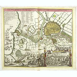
Das bombadirte Dantzig. Das belagerte Danzig eine Weltberühmte Haupt und Handelstatt des Polnischen Preussens, mit ihren Vorstaedten und der Weichselmünder Schanz,
Large original copper engraving with decorative set edge, top left Diarium of the Russian attack and Russian battleships in Gdansk Bay, above list of the most important b...
- $850 / ≈ €795
Place & Date: Nuremberg, 1734
Prussia accurate descriptia a Gasparo Henneberg Erlichensi.
Prussia and the Baltic Region, with two large decorative cartouches, coat of arms and three sailing ships. As indicated in the title cartouche, the map was prepared by th...
- $900 / ≈ €842
Place & Date: Amsterdam, 1660