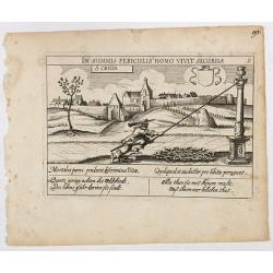
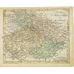
St. Cruis ( in eastern Poland.)
A very nice view of Kloster Heiligkreuz (Swiety Krzyz), in eastern Poland. In the foreground, a man climbing up a column is depicted. With a verse in two languages undern...
- $120 / ≈ €112
Place & Date: Frankfurt, 1623-1778
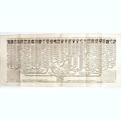
Nouvelle carte genealogique des souverains et des familles illustres aliez a la maison ou aux decendans de la famille roialle de Piaste roi de Pologne. . .
A two sheet engraving of the genealogical family tree of Poland from 804 AD to the time of publication. The tree extends throughout Europe and is headed by the arms of 30...
- $150 / ≈ €140
Place & Date: Amsterdam, 1719-1732
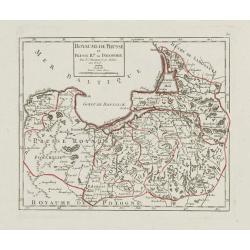
Royaume de Prusse et Prusse Rle. ou Polonoise.
On the left is Pomerania and the Desert of Waldow. At the top of the map is Memel and Samland. On the right side is the Biss River and Kautten. In the center of the map i...
- $125 / ≈ €117
Place & Date: Paris, later than 1749
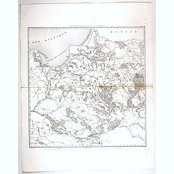
Carte du pays compris entre Vistule et la Pregel.
Map of Poland regions, including Warsaw, part of Russia and Danzig bay, prepared by Auguste Henri Dufour (1798-1865). Engraved by Ch. Dyonnet.
- $75 / ≈ €70
Place & Date: Paris, 1830
Boehmen, Mähren, Schliesien und die Lausitz.
Nice small map of Czechoslovakia and Silesia (Poland) by Johannes Walch in his rare Allgemeiner Atlas Nach den bewährsten Hülfsmitteln und astronomischen Ortsbestimunge...
- $100 / ≈ €94
Place & Date: Augsburg, 1812
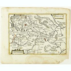
Moscovie. (34).
Scarce map of Muscovy and part of Poland and Lithuania published by Antoine de Fer in 1661 or 1662 in "Cartes de géographie revues et augmentées". The series ...
- $150 / ≈ €140
Place & Date: Paris, Antoine de Fer, 1657 but 1661 or 1662
![Partie septentrionale du cercle de Haute Saxe [...] Brandebourg.](/uploads/cache/33211-250x250.jpg)
Partie septentrionale du cercle de Haute Saxe [...] Brandebourg.
Finely and crisply engraved map of north eastern part of Germany, including part of Poland. With inset map of Brandenburg. Map by Giles Didier Robert De Vaugondy with era...
- $150 / ≈ €140
Place & Date: Paris, c. 1760
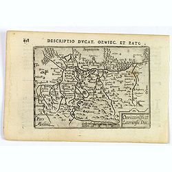
Descriptio Ducat. Ozwiec. et Zato.
An original early 17th century copper engraved miniature antique map of the Oswiecim (Auschwitz) and Zator area of southern Poland by Petrus Bertius. The title is display...
- $100 / ≈ €94
Place & Date: Amsterdam, 1606
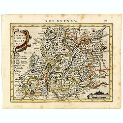
Ducatus Silesiae Glosani.
Charming map of the Silesia from the Mercator Hondius “Atlas Minor” published in Amsterdam in 1648 at Janssonius with German text on verso. Engraved by Petrus Kaerius...
- $200 / ≈ €187
Place & Date: Amsterdam, 1648
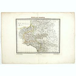
Reino de Polonia ò sea la parte unida a la Rusia por el repartimiento de 1795 que conserva el nombre de aquel antiguo reino.
Uncommon Spanish map of Poland from "Coleccion de mapas geograficos antiguos y modernos de autores clascicos", published by José Torner in Barcelona in 1831.R....
- $80 / ≈ €75
Place & Date: José Torner, Barcelona, 1831