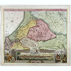
Prospect, Grundriss und Gegend der Polnischen vesten Reichs und Handels-Stadt Dantzig und ihrem Werder. . .
Striking example of Homann's map of Danzig (Gdansk) and neighboring regions and striking birds eye view, major port to the Baltic Ocean, which for centuries was an import...
- $550 / ≈ €484
Place & Date: Nuremberg, ca. 1720
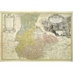
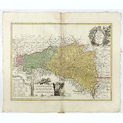
Silesiae Iavoriensis in IV Circulos, Iaver, Hirschberg, Lemberg und Buntzlau divisi ac. . .
Detailed map centered on Jelenia Góra ( Hirschberg), in southwestern Poland. The Sudeten (Sudety) mountains near the Czech border, pictorarily shown.Published in Atlas S...
Place & Date: Nuremberg, 1750
Selling price: $260
Sold in 2011
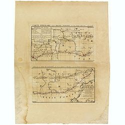
Polnische Reise Karte uber die vornehmsten Passagen von Dresden nach Warschau auf zweyerley Wegen I) uber Breslau, Peterkau und II) uber Lissa, Kaliez . . . 1751
Scarce strip-style road map showing two roads from Dresden via Glogau or Breslau to Warsaw.A key identifies villages, markets and post offices along the routes. Printed i...
Place & Date: Nurember, 1751
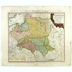
Mappa Geographica Regni Poloniae ex novissimis quot quot sunt mappis. . .
A map of Poland, Lithuania and Belarus, first published in 1750 by Homann Heirs, and now re-issued in 1773. Coastline includes all between Riga and Gdansk. Map is based o...
- $500 / ≈ €440
Place & Date: Nuremberg, 1773
Lubomeriae Et Galliciae Regni Tabula Geographica: Cum Priv. Sac. Caes. Maiestatis Impensis Homannianorum Haeredum . . .
Rare map of the Kingdom of Galicia and Lodomeria prepared by F.L. Güssefeld, (1744-1808), who was a cartographer from Osterburg, studied at Brandenburg, worked in Weimar...
- $1500 / ≈ €1321
Place & Date: Nuremberg, 1775
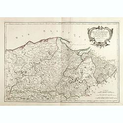
Carte De La Prusse Occidentale ou sont tracees les Provinces cedees Par la Pologne au Roi De Prusse . . . 1775
Finely and crisply engraved map of Western Prussia, now part of Poland on the Baltic Sea, including the Bay of Danzig. With ornamental title cartouche and noteworthy topo...
- $375 / ≈ €330
Place & Date: Venice, 1776 - 1784

Carte de la Pologne Autrichienne contenant La Russie Rouge et la partie méridionale du Palatinat de Cracovie . . .
Detailed map with Krakow, including the areas of Malopolskie and Podkarpackie and including present-day Ukraine.Santini gives credit to Homann Heirs in the cartouche. Mal...
- $300 / ≈ €264
Place & Date: Venise 1776-1784

Carte De La Prusse Occidentale ou sont tracees les Provinces cedees Par la Pologne au Roi De Prusse . . . 1775
Finely and crisply engraved map of Western Prussia, now part of Poland on the Baltic Sea, including the Bay of Danzig. With ornamental title cartouche and noteworthy topo...
- $250 / ≈ €220
Place & Date: Venice, 1776 - 1784