Browse Listings in Europe > Netherlands > Netherlands

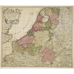
Belgium Foederatum emendate auctum et novissimé editum.
Fine detailed map of the area of the modern Netherlands less the southern part of Limburg. Title cartouche representing the commerce, the arts and the sciences. The Lion ...
Place & Date: Amsterdam, 1680

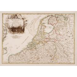
Les Provinces confederées du Pais-Bas
The first wall map of the Seven Provinces of 1651, re-issued as 'Stoel des Oorlogs' by Covens & Mortier. The first issue of the present wall-map is known to be includ...
Place & Date: Amsterdam, c. 1740
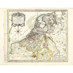
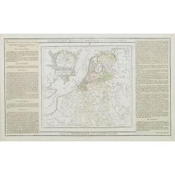
Septendecm. Provinciae Germaniae Inferior. . .
A general map of the Netherlands, Luxembourg and Belgium. Fine title cartouche showing Mercury, Neptune, globe, etc. Lower right coat of arms of 17 Provinces.
- $150 / ≈ €140
Place & Date: Amsterdam, 1700
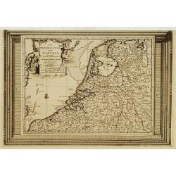
Partie Septentrionale des Pays Bas..
"Detailed map covering the Low Countries, published by Jean Latré."
- $400 / ≈ €374
Place & Date: Paris 1760

Die Republic Holland oder die Verenigte Niederlande..
Charming map of the Netherlands, with inset maps of Novi Belgium area in America and Indonesia. With a fine cartouche.
- $250 / ≈ €234
Place & Date: Leipzig 1749

Belgium Foederatum auctius et emendatius edit..
Map of the northern part of the Netherlands. With a decorative title cartouche, with an inset map of South East Asia.
- $500 / ≈ €468
Place & Date: Augsburg, 1760
Chorographie des Pays Bas Hollandois et Autrichiens. . .
Fine detailed and uncommon map of the modern Netherlands, Belgium and Luxembourg. Prepared by Etienne André Philippe de Pretot (1708-1787) after sources according to the...
- $200 / ≈ €187
Place & Date: Paris, 1772

Les Provinces des Pays Bas.
RARE. From his first edition of his only folio atlas, the map is relied upon the map of his uncle, Nicolas Sanson. Engraved by I.Somer.A nice map of Netherlands.
Place & Date: Paris 1687
Les Provinces Unies des Pays Bas, suivant les nouvelles observations. . .
With decorative title cartouche upper left corner.This example is unusual in having the additional separately engraved decorative framework border around the map, the res...
Place & Date: Amsterdam, 1728
Les Pays Bas François, Autrichiens, et Hollandois..
Finely engraved map centered on the Netherlands, extending to include Belgium and Luxembourg.Finely embellished with a large title cartouche surmounted by Mercury's head....
- $75 / ≈ €70
Place & Date: Paris, 1790