Browse Listings in Europe > Italy > Italy Provinces
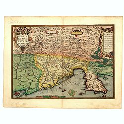
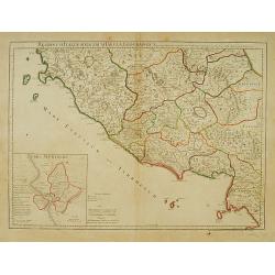
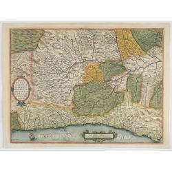
Fori Ivlii accvrata descriptio
Map from 'Theatrum Orbis Terrarum [Atlas of the Whole World]': published in Antwerp. Provenance: This map is from the personal collection of dr. Marcel van den Bro...
Place & Date: Antwerp, 1592
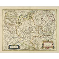
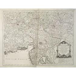
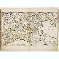
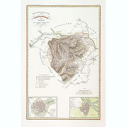
Mediolanum Ducatus.
Very fine map centered on Milan Including Lake Como, Lake Garda, Lake Majore, Parma, etc.As Willem Blaeu died in 1638 most of his maps are actually published by his son J...
Place & Date: Amsterdam, 1638
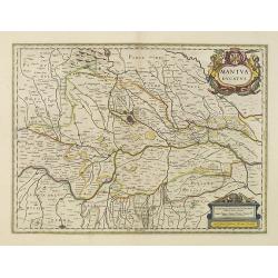
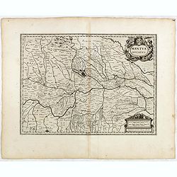
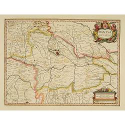
Mantua ducatus.
Centered at the town of Mantua.As Willem Blaeu died in 1638 most of his maps are actually published by his son Joan. This map carries his (engraved) signature and was act...
Place & Date: Amsterdam, 1638
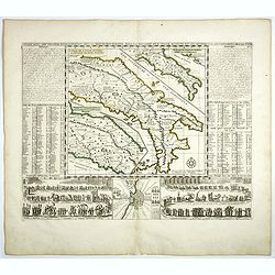
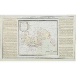
L'Italie dans son Premier Etablissement sous la Republique Romaine. . .
Map of Italy when first established under the Roman Republic after the division by Ayuguste Caesar, its various Papal governments: ancient Rome and its surround dings, a ...
Place & Date: Amsterdam, 1728
![[View of Caorle].](/uploads/cache/45190-250x250.jpg)
[View of Caorle].
Very rare view of Caorle, at the time an island, published in the first edition of "Viaggio da Venetia, a Costantinopoli. Per Mare, e per Terra, & infieme quello...
Place & Date: Venice, Giacomo Franco, 1598
![[View of Gulf of Trieste].](/uploads/cache/45191-250x250.jpg)
[View of Gulf of Trieste].
Very rare view of Gulf of Trieste published in the first edition of "Viaggio da Venetia, a Costantinopoli. Per Mare, e per Terra, & infieme quello di Terra Santa...
Place & Date: Venice, Giacomo Franco, 1598
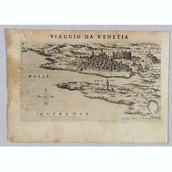
Polla Querrner [Pula in southern Istria)
Very rare view of Pula in southern Istria, published in the first edition of "Viaggio da Venetia, a Costantinopoli. Per Mare, e per Terra, & infieme quello di Te...
Place & Date: Venice, Giacomo Franco, 1598
![[San Nicola, Tremiti islands, in Italy. ]](/uploads/cache/45204-250x250.jpg)
[San Nicola, Tremiti islands, in Italy. ]
Very rare view of San Nicola, Tremiti islands, in Italy, published in the first edition of "Viaggio da Venetia, a Costantinopoli. Per Mare, e per Terra, & infiem...
Place & Date: Venice, Giacomo Franco, 1598
![[ View of Cruzola]](/uploads/cache/45205-250x250.jpg)
[ View of Cruzola]
Very rare view of Tremite Islands Island published in the first edition of "Viaggio da Venetia, a Costantinopoli. Per Mare, e per Terra, & infieme quello di Terr...
Place & Date: Venice, Giacomo Franco, 1598
![[ View of Ragusi]](/uploads/cache/45206-250x250.jpg)
[ View of Ragusi]
Very rare view of Ragusa published in the first edition of "Viaggio da Venetia, a Costantinopoli. Per Mare, e per Terra, & infieme quello di Terra Santa. Da Gios...
Place & Date: Venice, Giacomo Franco, 1598
Topografia di Alcune Antiche Citta Etrusche.
Very finely engraved and detailed map of several Etruscan cities. Engraved by Vettorio Angeliand included in: Atlante Geografico dell Italia .
Place & Date: Rome, 1860
Carte réduite du Golphe de Genes. Conenant partie des cotes de Provence, celles de Piemont, de Genes et de Toscane . . .
Superb sea chart covering the coasts of the French and Italian Riviera's, Tuscany and northern tip of Corsica, prepared by Jacques Nicolas Bellin (1703-1772) the Royal Hy...
Place & Date: Paris, 1768
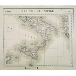
Europe. Naples et Sicile. N.26.
Detailed map including lower half of Italy with the island of Sicily.From his famous Atlas Universel . This atlas was one of the most remarkable world atlases ever produc...
Place & Date: Brussels, 1825-1827
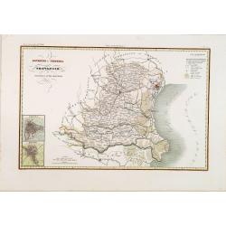
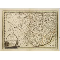
Partie Meridionale du Cercle d'Autriche qui comprend La basse partie du Duché de Strie, Le Duché de Carinthie, divisé en haute et basse, Le Duché de Carniole. . . Et l'Istrie Impériale. . .
Uncommon, finely and crisply engraved map with large decorative title cartouche.Very detailed sheet that is centered roughly on Trieste and extends in to the mouth of the...
Place & Date: Venice, 1784
![VIII. Carte de l'Etat de Genes [. . .] Toscane.](/uploads/cache/24551-250x250.jpg)
VIII. Carte de l'Etat de Genes [. . .] Toscane.
Detailed small map showing an area straddling the provinces of Genoa, La Spezia, Parma and Massa Carrara, Tuscany.Relief shown pictorially. From Atlas Portatif Universel,...
Place & Date: Paris, later than 1748
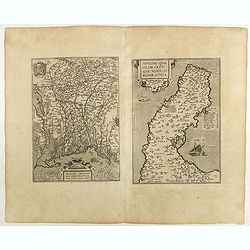
![Larii Lacus Vulgo Comensis Descriptio . . . [and] Terretorii Romani Descrip. [and] Fori Iulii Vulgo Frivli Typus. . .](/uploads/cache/48574-250x250.jpg)
Larii Lacus Vulgo Comensis Descriptio . . . [and] Terretorii Romani Descrip. [and] Fori Iulii Vulgo Frivli Typus. . .
Set of 3 maps of Lake Como, the region around Rome and the region around the Upper Adriatic, centered on Udinese from 'Theatrum Orbis Terrarum [Atlas of the Whole World]...
Place & Date: Antwerp, 1609/1612
Mantua ducatus.
Originally engraved for Jodocus Hondius II, at his death in August 1629 this map was, among 39 other copper plates, purchased by Willem Blaeu who deleted Hondius' name an...
- $300 / ≈ €281
Place & Date: Amsterdam, 1634
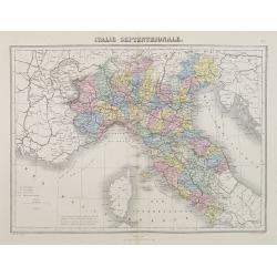
Italie Septentrionale.
A decorative map of northern Italy from Géographie Universelle, Atlas Migeon, published by J. Migeon.From one of the last decorative atlases published in the 19th centur...
- $25 / ≈ €23
Place & Date: Paris, 1874
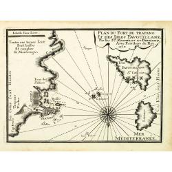
Plan du Port de Trapano et des isles Favouillane.
An attractive chart centered on Trapani on the west coast of Sicily in Italy. It is the capital of the Province of Trapani. The right the island of Favignana and Levanzo ...
- $300 / ≈ €281
Place & Date: Marseille, 1730
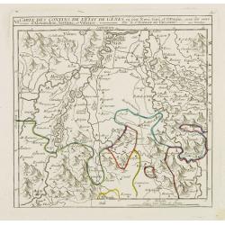
VI. Carte des Confins de l'Etat de Gênes où sont Novi, Gavi, et Ottagio..
Detailed small map encompassing the part of Piedmont between Alessandria, Tortona and Novi Ligure.Relief shown pictorially. From Atlas Portatif Universel, by Robert de Va...
- $150 / ≈ €140
Place & Date: Paris, later than 1748
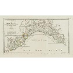
Carte Générale de l'Etat de Gênes.
Detailed map centered on the Gulf of Genoa. It shows the Italian region Liguria and extends westwards as far as Nice.Key map for the nine large-scale maps de Vaugondy mad...
- $100 / ≈ €94
Place & Date: Paris, ca. 1748
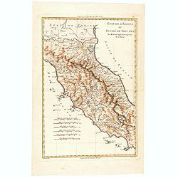
Etat de l'Eglise et Duché de Toscane.
Map of central Italy with Tuscany region by Rigobert Bonne.
- $75 / ≈ €70
Place & Date: Paris, 1771
Governo di Venezia / Provincie di Padova e di Rovigo.
Very finely engraved and detailed map of the government of Venice. Lower left corner, two inset plans of Padova and Rovigo. Upper right corner, a key. Engraved by Vettori...
- $300 / ≈ €281
Place & Date: Rome, 1860
Carte générale des marches, positions, combats et batailles de l'Armée de réserve. . . (N°12)
Very detailed map centered on the Italian Alps showing the marches, positions, combats and battles of the famous Napoleon's crossing the Alps in the year 8 (1799) . In an...
- $750 / ≈ €702
Place & Date: Paris, 1803
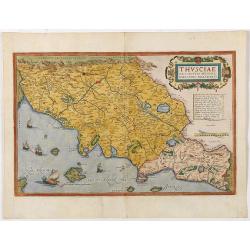
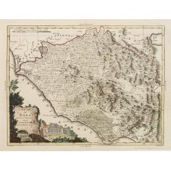
Thusciae Descriptio Auctore Hieronimo Bellarmato.
Decorative and detailed map of Tuscany, from the 1574 or 1575 Latin text edition of Ortelius' Theatrum Orbis Terrarum, the first modern atlas of the world. The map is bas...
- $900 / ≈ €842
Place & Date: Antwerp, 1574-1575
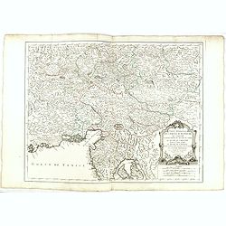
Partie Meridionale du Cercle d'Autriche qui comprend La basse partie du Duché de Strie, Le Duché de Carinthie, divisé en haute et basse, Le Duché de Carniole. . . Et l'Istrie Impériale. . .
Uncommon, finely and crisply engraved map with large decorative title cartouche.Very detailed sheet that is centered roughly on Trieste and extends in to the mouth of the...
- $100 / ≈ €94
Place & Date: Venice, 1784
L'Etat de Venise et le Duché de Mantoue..
Attractive map covering the region centered on today region Veneto and its chief town Venice.Extending westwards to include part of Lombardy and eastward to Trieste and I...
- $100 / ≈ €94
Place & Date: Paris, 1790
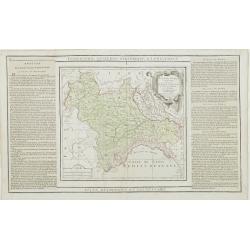
Carte Générale de Lombardie.
Fine map of Northern and middle part of Italy, engraved by A Peyrouin. According to the credit in the cartouche the map has been prepared by Pierre Duval.
- $300 / ≈ €281
Place & Date: Paris, ca. 1650
V. Compartimento Grossetano. . .
Very finely engraved and detailed map of Tuscany, centered on Grosseto. The island of Elba in left part.. In the corners insets of Sovana, Massa, Piombino, Orbetello and ...
- $200 / ≈ €187
Place & Date: Rome, 1860
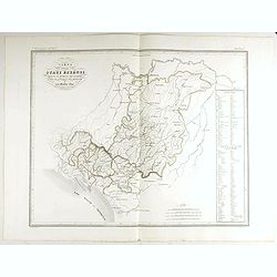
Carta degla Stati Estensi avanti il domino dei Romani Sotto Il governo dei Medesimi.
Very finely engraved and detailed map of the Duchy of Lucca before the dominion of the Romans under the rule of the same and in the Middle AgesWith a key on the right par...
- $200 / ≈ €187
Place & Date: Rome, 1860
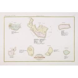
![[Lake Garda and its surroundings].](/uploads/cache/46166-250x250.jpg)
[Lake Garda and its surroundings].
Alexey Afinogenovich Ilyin was a lieutenant general and cartographer (1832-1889). In 1856, after graduating from the Academy of the General Staff, he was at the military ...
- $100 / ≈ €94
Place & Date: St. Petersburg, 1899

Latium.
Based on classical authors' sources, specifically Virgilius, Plinius, Varro, Halicarnasseus, Festus and Ausonius.Philip Wingius in his letter to Ortelius from 1592 mentio...
Place & Date: Antwerp, 1595
Partie de l' Italie, comprenant les Etats du Roy de Sardaigne. . .
Decorative map of northwest Italy and the Golfo di Genova. With ornamental title cartouche.Flanked by two columns of French text containing geographical information about...
- $100 / ≈ €94
Place & Date: Paris, 1790
Regionum Italiae mediarum Tabula Geographica. . .
Fine historical map of central Italy with Tuscany, centered on Rome, in the south Pompeii, in the top the island of Giglio and the town Orbetello. Lower left inset plan o...
- $150 / ≈ €140
Place & Date: Paris, 1745
Campagna di Roma Di nuova Projezione. . .
A very striking map of the area south east of Rome, engraved by G.Pitteri embellished with an colored pictorial title cartouche.
Place & Date: Venice, 1798
Selling price: $200
Sold in 2015
IV Compartimento Aretoni. . .
Very finely engraved and detailed map centered on Arezzo and Lago Trasimeno. Lower part three inset plans of Cortona, Arezzo and Chiusi. In upper corners plans of Montepu...
- $200 / ≈ €187
Place & Date: Rome, 1860
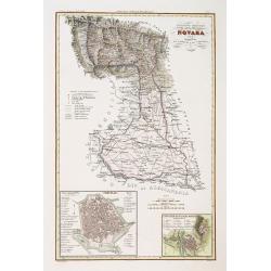
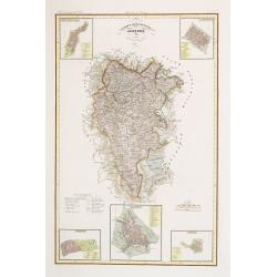
Divisione militaire di Novara. Provincie di Valsesia e di Vercelli.
Very finely engraved and detailed map centered on Vercelli and Varalio. Lower part two inset plans of Vercelli and Varallo and sacro Monte. Engraved by Pietro Manzoni and...
- $200 / ≈ €187
Place & Date: Rome, 1860
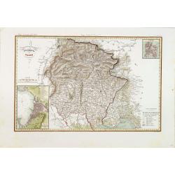
Governo di Venezia / Provincia di Udine.
Very finely engraved and detailed map of the area of Udine, with Trieste in lower right corner. Lower left corner an inset plan of Trieste : upper right corner, an inset ...
- $300 / ≈ €281
Place & Date: Rome, 1860
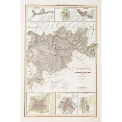
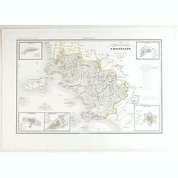
Compartimento Fiorentino. (Florence)
Very finely engraved and detailed map of the province of Firenze (Florence) Upper and lower part of the map, three inset plans of Namminiato, Modigliani and Volterra, Pis...
- $250 / ≈ €234
Place & Date: Rome, 1860
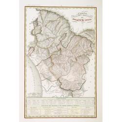
Ducato di Lucca.
Very finely engraved and detailed map of the region around Lucca. Lower part of the map, two inset lists of the mountains height and the local minerals. Engraved by Vetto...
- $200 / ≈ €187
Place & Date: Rome, 1860
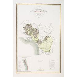
Compartimento Pisano.
Very finely engraved and detailed map of the territory of Pisa, including the region of Lucca and Estense. Lower left corner, an inset plan of Pontremoli. Lower right cor...
- $200 / ≈ €187
Place & Date: Rome, 1860
Mantua ducatus.
Important map of northern Italy centered on the dramatic fortress of Mantua.
- $300 / ≈ €281
Place & Date: Amsterdam, 1635
![[Toscana / Tuscany] En, candidi lectores, elegantioris Italiae partis, Tusciae scilicet, topographiam. aenis nris formis excussam in hac Tabella vobis denuo damus. . .](/uploads/cache/47717-250x250.jpg)
[Toscana / Tuscany] En, candidi lectores, elegantioris Italiae partis, Tusciae scilicet, topographiam. aenis nris formis excussam in hac Tabella vobis denuo damus. . .
A rare map of Tuscany, including the islands of Elba, Giglio, Giannutri and part of Corsica, and covering the whole of Tuscany, part of Liguria, Lombardy, Emilia, Umbria,...
- $6000 / ≈ €5614
Place & Date: Rome, ca 1557
L'alta Lombardia, Terzo Foglio Che comprende parte degli Stati del Re di Sardegna e parte della Repubblica di Genova.
Interesting map covering the border between France and Italy. In Nuovo Atlante Geografico Universale.
- $200 / ≈ €187
Place & Date: Rome, 1791
Divisione Militare di Genova. Albenga / Savona.
Very finely engraved and detailed map covering the Mediterranean coast from Oneglia, Albenga, Noli until Savona. Upper corners, two inset plans of Savona and Albenga. Key...
- $150 / ≈ €140
Place & Date: Rome, 1860
Governo di Milano / Provincia di Mantova e Cremona.
Very finely engraved and detailed map centered on Mantua, including Cremona. Lower corners two inset plans of Mantua and Cremona. Upper left corner, a key. Engraved by Ve...
- $150 / ≈ €140
Place & Date: Rome, 1860
Compartimento Pisano.
Very finely engraved and detailed map centered on Pisa, including Livorno. Centered on the lower part, an inset plan of Pisa. Lower left corner, a key. Engraved by Vetto...
- $200 / ≈ €187
Place & Date: Rome, 1860
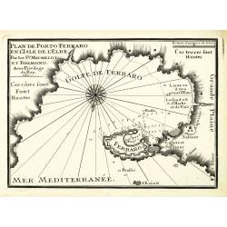
Plan de Porto Ferraro en l'isle de l'Elbe.
An attractive chart centered on the Mediterranean. With scale and large compass-rose. Dated 1727, with the privilege of the King. From : Recueil des Plusieurs plans des p...
- $200 / ≈ €187
Place & Date: Marseille, 1730
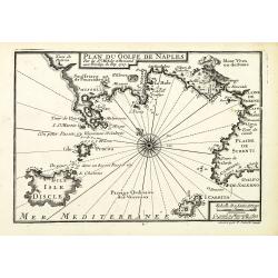
Plan du Golfe de Naples.
An attractive chart centered on the Gulf of Naples. Mount Vesuvius to the right. With scale and large compass-rose. Dated 1727, with the privilege of the King. From : Rec...
- $150 / ≈ €140
Place & Date: Marseille, 1730
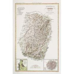
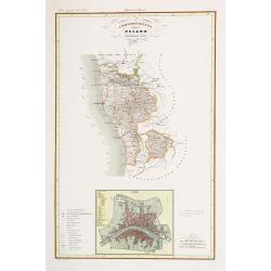
Divisione Militare di Cuneo. Mondovi / Alba.
Very finely engraved and detailed map of Cuneo, centered on the towns of Mondovi and Alba. Lower corners, two inset plans of Mondovi and Alba. Upper right corner, a key. ...
- $200 / ≈ €187
Place & Date: Rome, 1860
Divisione Militare di Alessandria. Provincie di Casale e di Asti.
"Published in ""Atlante Geografico dell' Italia"". With inset cartouche with detailed plans of the cities of Asti and Casale. Showing the river P...
- $200 / ≈ €187
Place & Date: Florence, 1845
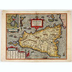
Siciliae Veteris Typus.
A very beautiful early map of ancient Sicily. Title cartouche centered on the upper part: includes also an inset map of Syracuse in the upper left, and a list of the town...
- $600 / ≈ €561
Place & Date: Antwerp, 1587
(Untitled map of northern Italy)
Including the towns of Milan, Bergamo, Mantova, Verona with the river Po in the bottom. One page from his multi sheet map "Carta del Territorio della Repubblica Casa...
- $250 / ≈ €234
Place & Date: Florence, 1797
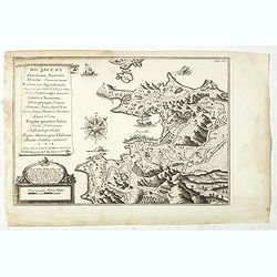
Hic Jacent Puteolorum Bajarum, Miseni Cumarium. . .
A bird's-eye view of Puzzoli and environs, depicting fascinating topographical and architectural features of interest. Title cartouche describes the map and area in Latin...
- $80 / ≈ €75
Place & Date: London, 1725-1744
Pedemontanae Vicinorumque Regionum.
Fine map including the Italian coast from Monaco till Genoa. Milan in the upper righthand corner and Turin in the center of the map.
- $600 / ≈ €561
Place & Date: Antwerp, 1574-1575
Parte Occidentale del Regno Italico, Il Piemonte e Genovestato.
Rare map of Piemonte region in Italy, centered on Piemonte region, Genova and Milan, from "Atlante Novissimo ad uso Dei Giovani Studiosi Contenuto In Carte XXVII.&qu...
- $75 / ≈ €70
Place & Date: Rome, 1780
Patavini territorii../ Tarvisini agri typus.. (2 maps on one sheet)
Two maps on one sheet. Map to the left is a detailed map including Venice and the area north of it, including Padua and Vincenza. Very fine map after Giacomo Gastaldi. Th...
- $300 / ≈ €281
Place & Date: Antwerp, 1598
![Larii Lacus Vulgo Comensis Descriptio . . . [and] Terretorii Romani Descrip. [and] Fori Iulii Vulgo Frivli Typus. . .](/uploads/cache/41008-250x250.jpg)
Larii Lacus Vulgo Comensis Descriptio . . . [and] Terretorii Romani Descrip. [and] Fori Iulii Vulgo Frivli Typus. . .
Set of 3 maps of Lake Como, the region around Rome and the region around the Upper Adriatic, centered on Udinese from 'Theatrum Orbis Terrarum [Atlas of the Whole World]'...
Place & Date: Antwerp, 1598
Le Royaume de Sicile.
Uncommon map Sicily and part of Palermo. Very good impression.Like Sanson, Briet was born in Abbeville and became a Jesuit at age 18. His "Parallela Geographiae Vete...
Place & Date: Paris, 1653
![Nova & exacta Chorographia Latii sive Territorii Romani iuxta veterem et novum situm parallela nomimu[m] comparatione elaborata.](/uploads/cache/44863-250x250.jpg)
Nova & exacta Chorographia Latii sive Territorii Romani iuxta veterem et novum situm parallela nomimu[m] comparatione elaborata.
Map of central Italy, centered on Rome from "Latium" by A. Kircher and designed by Innocenzo Mattei. The title cartouche in the lower right, small legend with 1...
Place & Date: Amsterdam, 1671
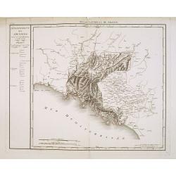
Département des Apennins Divisé en 3 Arrondissemens et en 18 cantons.
Published in the "Atlas National de France" at Chanlaire. Engraved by P.A.F. Tardieu. Represents the department of Apennines which was under French administrati...
Place & Date: Paris, 1790-1811

Florentini Dominii Fidelissima et nova descriptio.
The map is centered on the city of Florence and extends to Liguria, the Apennine Mountains, the Adriatic Coast, Siena and Lago di Perugia. The map is based upon Stefano B...
Place & Date: Anvers, 1598
![[ Manuscript map of the Ligurian coast from Pietra to Genova ].](/uploads/cache/26627-250x250.jpg)
[ Manuscript map of the Ligurian coast from Pietra to Genova ].
Very detailed French manuscript map of the Ligurian coast from Pietra and Finale, Savone to Genoa with the Maritime Alps in the background. The Liguria coast borders to n...
Place & Date: France, ca. 1790-1800

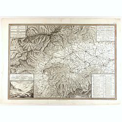
Les vallées du Piemont. Habitees par les Vaudois ou Berbets. . .
Detailed map of Piedmont region covering French and Italian territories. Surrounded by a French text description "Description des vallées du Piemont qu'habitent par...
Place & Date: Paris, 1690

Dominio Veneto nell' Italia.
With the Gulf of Venice. Including the towns of Cremona, Brescia, Venice, etc.As Willem Blaeu died in 1638 most of his maps are actually published by his son Joan. This m...
Place & Date: Amsterdam, 1638

La marca d'Ancona. Marchia Anconitana Picaenum olim dicta. . . Romae apud Joannem Orlandini formis Rome 1604.
A re-issue of the plate by Vicentium Luchinù of 1564 now with the address of Orlandini and the dates 1602 / 1604.Collector's item. A unique opportunity to acquire a fine...
Place & Date: Rome, 1604