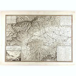
Carte générale des marches, positions, combats et batailles de l'Armée de réserve. . . (N°12)
Very detailed map centered on the Italian Alps showing the marches, positions, combats and battles of the famous Napoleon's crossing the Alps in the year 8 (1799) . In an...
- $750 / ≈ €702
Place & Date: Paris, 1803
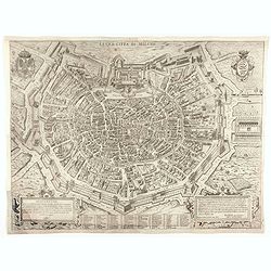
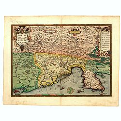
La Gra. Citta di Milano.
Extremely rare city map of Milan. The plan showing the city within the city walls, with the surrounding countryside, title and dedicatory verse set in elaborate strapwork...
- $2000 / ≈ €1871
Place & Date: Rome, 1602
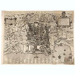
Palermo.
Rare bird's-eye view of Palermo, the plan showing the city and harbor within the city walls, with the surrounding countryside, title and dedicatory verse set in elaborate...
- $3000 / ≈ €2807
Place & Date: Seina, ca. 1600
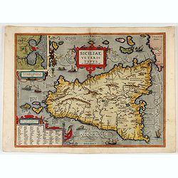
Siciliae Veteris Typus.
A very beautiful early map of ancient Sicily. Title cartouche centered on the upper part: includes also an inset map of Syracuse in the upper left, and a list of the town...
- $600 / ≈ €561
Place & Date: Antwerp, 1587
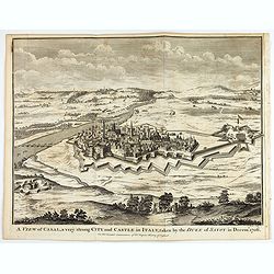
A view of Cassel, a very strong city in Italy, taken by the Duke of Savoy in Decem.r 1706
An interesting copper engraved plan of the Fortification of Cassel in Italy, with an attractive rococo cartouche, showing an overview of the battlefield and surrounding a...
Place & Date: London, 1743
![[Toscana / Tuscany] En, candidi lectores, elegantioris Italiae partis, Tusciae scilicet, topographiam. aenis nris formis excussam in hac Tabella vobis denuo damus. . .](/uploads/cache/47717-250x250.jpg)
[Toscana / Tuscany] En, candidi lectores, elegantioris Italiae partis, Tusciae scilicet, topographiam. aenis nris formis excussam in hac Tabella vobis denuo damus. . .
A rare map of Tuscany, including the islands of Elba, Giglio, Giannutri and part of Corsica, and covering the whole of Tuscany, part of Liguria, Lombardy, Emilia, Umbria,...
- $6000 / ≈ €5614
Place & Date: Rome, ca 1557
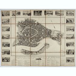
Pianta Topografica della R.a Città di Venezia con XIX de suoi principali prospetti.
A detailed town plan of Venice with an extensive key underneath and nineteen views of the important buildings among which : Piazza di S. Marco, Canal Grande, Tempio della...
Place & Date: Milan: Santo Vallardi, c.1840
![Quarta etas mudi Folio LVIII [Rome]](/uploads/cache/48488-250x250.jpg)
Quarta etas mudi Folio LVIII [Rome]
Double text page in German with a woodblock Rome (23x53cm.)On verso a view of Genua (193x222mm). Page from the richest illustrated Incunable, the famous: Nuremberg Chro...
Place & Date: Nuremberg, 12 July 1493

Latium.
Based on classical authors' sources, specifically Virgilius, Plinius, Varro, Halicarnasseus, Festus and Ausonius.Philip Wingius in his letter to Ortelius from 1592 mentio...
Place & Date: Antwerp, 1595
![Larii Lacus Vulgo Comensis Descriptio . . . [and] Terretorii Romani Descrip. [and] Fori Iulii Vulgo Frivli Typus. . .](/uploads/cache/48574-250x250.jpg)
Larii Lacus Vulgo Comensis Descriptio . . . [and] Terretorii Romani Descrip. [and] Fori Iulii Vulgo Frivli Typus. . .
Set of 3 maps of Lake Como, the region around Rome and the region around the Upper Adriatic, centered on Udinese from 'Theatrum Orbis Terrarum [Atlas of the Whole World]...
Place & Date: Antwerp, 1609/1612
Fori Ivlii accvrata descriptio
Map from 'Theatrum Orbis Terrarum [Atlas of the Whole World]': published in Antwerp. Provenance: This map is from the personal collection of dr. Marcel van den Bro...
Place & Date: Antwerp, 1592
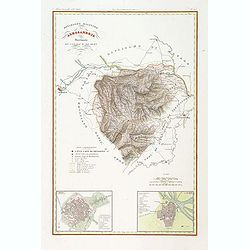
Divisione Militare di Alessandria. Provincie di Casale e di Asti.
"Published in ""Atlante Geografico dell' Italia"". With inset cartouche with detailed plans of the cities of Asti and Casale. Showing the river P...
- $200 / ≈ €187
Place & Date: Florence, 1845

Pianta Della Citta di Roma con la Indicazione di tutte le Antichita e Nuovi Abbelliment.
Beautiful engraved town-plan of Rome with side borders depicting the 16 most important monuments and with a legend locating the major places and buildings.The views are o...
Place & Date: Venanzio Monaldini, Rome, 1829
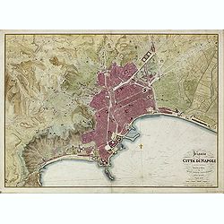
Pianta della Citta di Napoli e de' soui contorni.
Uncommon large scale town-plan of Naples. Drawn and engraved by the "Reale officio topografico".
- $1500 / ≈ €1404
Place & Date: Naples, 1828
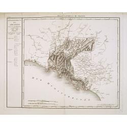
Département des Apennins Divisé en 3 Arrondissemens et en 18 cantons.
Published in the "Atlas National de France" at Chanlaire. Engraved by P.A.F. Tardieu. Represents the department of Apennines which was under French administrati...
Place & Date: Paris, 1790-1811