
Guide de Florence et de ses environs Redige´ sur un plan entierement nouveau par l'Abbé A. Bulgarini et Traduit en français par A. Le Rendu. Deuxième édition.
Second edition. With 1 engr. folding plan (Pianta della Citta di Firenze. I. Balatri inc. e scris.) and 12 copper plates with views in Florence. The folding plan has meas...
- $550 / ≈ €515
Place & Date: Florence, Gaspard Ricci, 1839

Vue interieur de l'Eglise de S.Pierre de Rome.
So-called optical print of St. Pieter church of Rome. A well-known publisher of optical prints, established in Paris. In the eighteenth and nineteenth centuries there wer...
Place & Date: Paris, 1760
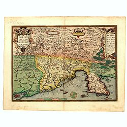
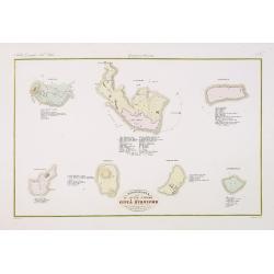
Fori Ivlii accvrata descriptio
Map from 'Theatrum Orbis Terrarum [Atlas of the Whole World]': published in Antwerp. Provenance: This map is from the personal collection of dr. Marcel van den Bro...
Place & Date: Antwerp, 1592
![Larii Lacus Vulgo Comensis Descriptio . . . [and] Terretorii Romani Descrip. [and] Fori Iulii Vulgo Frivli Typus. . .](/uploads/cache/48574-250x250.jpg)
Larii Lacus Vulgo Comensis Descriptio . . . [and] Terretorii Romani Descrip. [and] Fori Iulii Vulgo Frivli Typus. . .
Set of 3 maps of Lake Como, the region around Rome and the region around the Upper Adriatic, centered on Udinese from 'Theatrum Orbis Terrarum [Atlas of the Whole World]...
Place & Date: Antwerp, 1609/1612
![[ View of Ragusi]](/uploads/cache/45206-250x250.jpg)
[ View of Ragusi]
Very rare view of Ragusa published in the first edition of "Viaggio da Venetia, a Costantinopoli. Per Mare, e per Terra, & infieme quello di Terra Santa. Da Gios...
Place & Date: Venice, Giacomo Franco, 1598
![[ View of Cruzola]](/uploads/cache/45205-250x250.jpg)
[ View of Cruzola]
Very rare view of Tremite Islands Island published in the first edition of "Viaggio da Venetia, a Costantinopoli. Per Mare, e per Terra, & infieme quello di Terr...
Place & Date: Venice, Giacomo Franco, 1598
![[San Nicola, Tremiti islands, in Italy. ]](/uploads/cache/45204-250x250.jpg)
[San Nicola, Tremiti islands, in Italy. ]
Very rare view of San Nicola, Tremiti islands, in Italy, published in the first edition of "Viaggio da Venetia, a Costantinopoli. Per Mare, e per Terra, & infiem...
Place & Date: Venice, Giacomo Franco, 1598
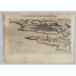
Polla Querrner [Pula in southern Istria)
Very rare view of Pula in southern Istria, published in the first edition of "Viaggio da Venetia, a Costantinopoli. Per Mare, e per Terra, & infieme quello di Te...
Place & Date: Venice, Giacomo Franco, 1598
![[View of Gulf of Trieste].](/uploads/cache/45191-250x250.jpg)
[View of Gulf of Trieste].
Very rare view of Gulf of Trieste published in the first edition of "Viaggio da Venetia, a Costantinopoli. Per Mare, e per Terra, & infieme quello di Terra Santa...
Place & Date: Venice, Giacomo Franco, 1598
![[View of Caorle].](/uploads/cache/45190-250x250.jpg)
[View of Caorle].
Very rare view of Caorle, at the time an island, published in the first edition of "Viaggio da Venetia, a Costantinopoli. Per Mare, e per Terra, & infieme quello...
Place & Date: Venice, Giacomo Franco, 1598
![Venetia. [Venice ]](/uploads/cache/45176-250x250.jpg)
Venetia. [Venice ]
Very rare view of Venice published in the first edition of "Viaggio da Venetia, a Costantinopoli. Per Mare, e per Terra, & infieme quello di Terra Santa. Da Gios...
Place & Date: Venice, Giacomo Franco, 1598
Carte du gouvernement militaire de la République de Venise . . .
Very decorative folio sheet with five engraved views in Venice: "Vue de la Palace de St. Marc" (Piazza San Marco), a birds-eye map of "L'Arcenal", &qu...
Place & Date: Amsterdam, 1720
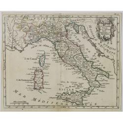
L'Italie dans son Premier Etablissement sous la Republique Romaine. . .
Map of Italy when first established under the Roman Republic after the division by Ayuguste Caesar, its various Papal governments: ancient Rome and its surround dings, a ...
Place & Date: Amsterdam, 1728
Topografia di Alcune Antiche Citta Etrusche.
Very finely engraved and detailed map of several Etruscan cities. Engraved by Vettorio Angeliand included in: Atlante Geografico dell Italia .
Place & Date: Rome, 1860
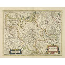
Mediolanum Ducatus.
Very fine map centered on Milan Including Lake Como, Lake Garda, Lake Majore, Parma, etc.As Willem Blaeu died in 1638 most of his maps are actually published by his son J...
Place & Date: Amsterdam, 1638
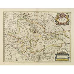
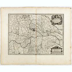
Mantua ducatus.
Centered at the town of Mantua.As Willem Blaeu died in 1638 most of his maps are actually published by his son Joan. This map carries his (engraved) signature and was act...
Place & Date: Amsterdam, 1638
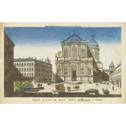
Eglise et place de Saint Andre dellavalle à Rome.
Perspective view of the church and place Sant'Andrea della Valle church in Rome. Sant'Andrea della Valle later became a model for the construction of other churches like ...
Place & Date: Paris, 1760
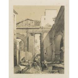
Portique d'Octavie à Rome.
Uncommon and decorative lithography of the Porticus Octaviae (portico of Octavia) in Rome. Published by Carl Johan Billmark and printed by Lemercier in Paris, 55 rue de S...
Place & Date: Paris, c.1859
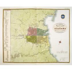
Pianta della citta di Palermo e dei suoi contorni.
Published in Atlante Geografico dell' Italia . Uncommon and decorative town-plan of Palermo. With a numbered key.Engraved by P. Manzoni.
Place & Date: Florence, 1845
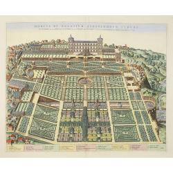
Hortus et Palatium Atestinorum Tyburi.
Showing in great detail the hortus and gardens of Villa Tivoli.Joan Blaeu published during his life three town-books of Italy: Citta del Vaticano, Roma and Napoli. By the...
Place & Date: Amsterdam, 1705
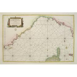
Carte réduite du Golphe de Genes. Conenant partie des cotes de Provence, celles de Piemont, de Genes et de Toscane . . .
Superb sea chart covering the coasts of the French and Italian Riviera's, Tuscany and northern tip of Corsica, prepared by Jacques Nicolas Bellin (1703-1772) the Royal Hy...
Place & Date: Paris, 1768
Carte d' Italie . . .
Map of Italy from Atlas moderne portatif composé de vingt-huit cartes sur toutes les parties du globe terrestre .. A l'usage des Colléges, des Pensions & des Maison...
Place & Date: Paris, Prudhomme, Levrault, Debray, 1806
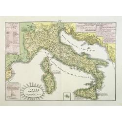
L'Italia antica-romana.
A rare and detailed double-page map of ancient Italy. According to the title cartouche, prepared by A de La Sage for l'Atlante Storico, Letterario, Biografico, Archeologi...
Place & Date: Venice, 1840
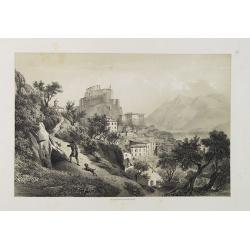
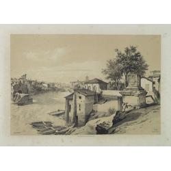
Subiaco. Environs de Rome.
Uncommon and picturesque view of Subiaco in the Province of Rome, in Lazio. Subiaco is famous as it was the first city in Italy where books were printed, in the 15th cent...
Place & Date: Paris, ca.1859
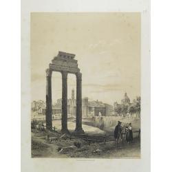
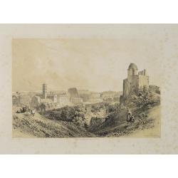
Rome. Les Trois colonnes de Grecostatis, et le Forum Romanum.
Uncommon and picturesque lithography of the Forum Romanum in Rome. On foreground the remains of the Temple of Castor and Pollux.Published by Carl Johan Billmark and print...
Place & Date: Paris, c.1859
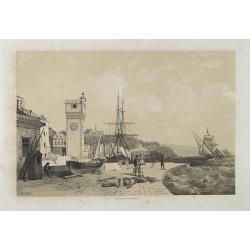
Savona Golfe de Gênes.
Uncommon and picturesque view of Sanova in the northern Italian region of Liguria in the Riviera di Ponente on the Mediterranean Sea. Published by Carl Johan Billmark and...
Place & Date: Paris, ca.1859
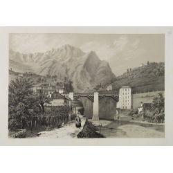
Pont du Crevola au pied de Simplon (Italie).
Uncommon and picturesque lithography of the Crevola Bridge at the foot of the Simplon Mountain in Italy. Published by Carl Johan Billmark and printed by Lemercier in Pari...
Place & Date: Paris, ca.1859
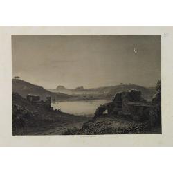
Lac d'Averne (Roye. De Naples).
Uncommon and picturesque lithography of the Lake Avernus (Lago d'Averno). It was believed to be the entrance to the underworld, and is portrayed as such in the Aeneid of ...
Place & Date: Paris, c.1859
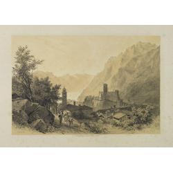
Lac de Garda Vue prise à Teno.
Uncommon and picturesque view of the Garda lake from the town of Teno. Published by Carl Johan Billmark and printed by Lemercier in Paris, 55 rue de Seine, the leading fi...
Place & Date: Paris, c.1859
Rome (Ponte Rotto).
Uncommon and picturesque lithography of Rome with a view of the Rotto Bridge. Published by Carl Johan Billmark and printed by Lemercier in Paris, 55 rue de Seine, the lea...
Place & Date: Paris, c.1859
Rome. Vue prise du Mont Palatin.
Uncommon and picturesque lithography of Rome. View from Mount Palatin. Published by Carl Johan Billmark and printed by Lemercier in Paris, 55 rue de Seine, the leading fi...
Place & Date: Paris, c.1859

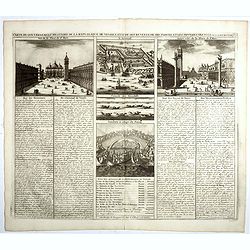
Vue des trois Gallerie, du Palais des Arts..Science a Rome.
So-called optical print. Daumont was a well-known publisher of optical prints, established in Paris. In the eighteenth and nineteenth centuries there were many popular sp...
Place & Date: Paris, 1760
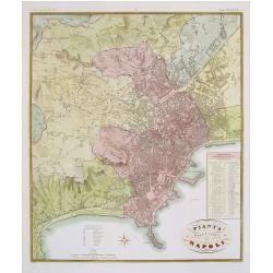
Pianta della citta di Napoli.
Published in Atlante Geografico dell' Italia. Uncommon and decorative town-plan of Naples. With a numbered key.Engraved by P.Manzoni.
Place & Date: Florence, 1845
Selling price: $500
Sold in 2008
![VIII. Carte de l'Etat de Genes [. . .] Toscane.](/uploads/cache/24551-250x250.jpg)
VIII. Carte de l'Etat de Genes [. . .] Toscane.
Detailed small map showing an area straddling the provinces of Genoa, La Spezia, Parma and Massa Carrara, Tuscany.Relief shown pictorially. From Atlas Portatif Universel,...
Place & Date: Paris, later than 1748
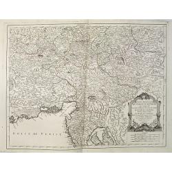
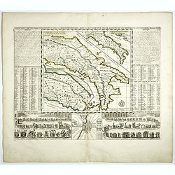
Partie Meridionale du Cercle d'Autriche qui comprend La basse partie du Duché de Strie, Le Duché de Carinthie, divisé en haute et basse, Le Duché de Carniole. . . Et l'Istrie Impériale. . .
Uncommon, finely and crisply engraved map with large decorative title cartouche.Very detailed sheet that is centered roughly on Trieste and extends in to the mouth of the...
Place & Date: Venice, 1784
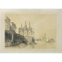
S. Maria della Spina (à Pise).
Uncommon lithography of the Church of S. Maria della Spina in Pisa. Published by Carl Johan Billmark and printed by Lemercier in Paris, 55 rue de Seine, the leading firm ...
Place & Date: Paris, c.1859
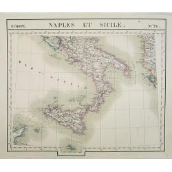
Europe. Naples et Sicile. N.26.
Detailed map including lower half of Italy with the island of Sicily.From his famous Atlas Universel . This atlas was one of the most remarkable world atlases ever produc...
Place & Date: Brussels, 1825-1827

Lac de Nemi (environs de Rome).
Uncommon and picturesque lithography of Lake Nemi, a small circular volcanic lake in the Lazio region, 30 kilometers south of Rome. Published by Carl Johan Billmark and p...
Place & Date: Paris, c.1859

Les Trois Temples de Pestum. Royaume de Naples.
Uncommon and decorative lithography of the Temples of Paestum near Naples. Published by Carl Johan Billmark and printed by Lemercier in Paris, 55 rue de Seine, the leadin...
Place & Date: Paris, c.1859
Mantua ducatus.
Originally engraved for Jodocus Hondius II, at his death in August 1629 this map was, among 39 other copper plates, purchased by Willem Blaeu who deleted Hondius' name an...
- $300 / ≈ €281
Place & Date: Amsterdam, 1634