
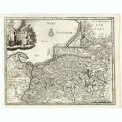
Prussiae Regionis Sarmatiae Europae Nobilissimae Novaet vera descriptio . . .
Nice example of the first edition of De Jode's map of Prussia, from the 1593 edition of De Jode's atlas.The present map is an entirely new addition to the second De Jode ...
- $2000 / ≈ €1871
Place & Date: Antwerp, 1593
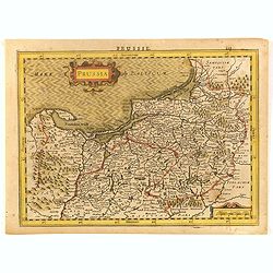
Prussia.
An attractive, detailed and early map of present-day Poland and Lithuania. From the Cloppenburg edition slightly larger format and more scarce edition of the Mercator/Hon...
- $450 / ≈ €421
Place & Date: Amsterdam, 1630
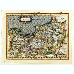
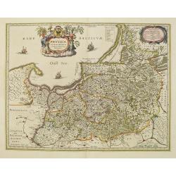
Prussia.
An attractive, detailed and early map of present-day Poland and Lithuania from the rare Cloppenburg edition slightly larger format and more scarce edition of the Mercator...
Place & Date: Amsterdam, 1630
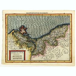
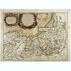
Pomeraniae Ducatus.
Pomerania map from the rare Cloppenburg edition slightly larger format and more scarce edition of the Mercator/Hondius "Atlas Minor". Small and detailed map of ...
Place & Date: Amsterdam, 1630
Prussia accurate descriptia a Gasparo Henneberg Erlichensi.
Prussia and the Baltic Region, with two large decorative cartouches, coat of arms, and three sailing ships. As indicated in the title cartouche, the map was prepared by t...
Place & Date: Amsterdam, 1644
Selling price: $500
Sold in 2017
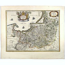
Prussiae nova tabula.
Rare map of Prussia with nowadays Poland. The map features a bold title cartouche, a ship, compass rose, and a sea monster in the Baltic Sea. The map was prepared by the ...
- $550 / ≈ €515
Place & Date: Amsterdam, 1647
Prussia accurate descriptia a Gasparo Henneberg Erlichensi.
Prussia and the Baltic Region, with two large decorative cartouches, coat of arms and three sailing ships. As indicated in the title cartouche, the map was prepared by th...
- $900 / ≈ €842
Place & Date: Amsterdam, 1660
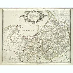
La Prussia Divisa in Reale Che Appartiene al Ré Di Polonia et in Ducale Che Spetta all'Elettore Di Brandeburgo. Da Giacomo Cantelli Da ...
In the upper left-hand corner a large title cartouche with a dedication to Cardinal Denhoff. The map is dated 1689.The cartographer was Giacomo Cantelli (1643-1695) who w...
- $1000 / ≈ €936
Place & Date: Rome, 1689

Magnae Prussiae Ducatus Tabula denuo correcta et in lucem edita per Nicolaum Visscher.
Striking old color example of Visscher's map of Prussia and part of the Baltic region. Includes a gorgeous cartouche and banner key held aloft by 2 cherubs, plus 4 sailin...
- $1500 / ≈ €1404
Place & Date: Amsterdam, 1690
La Prusse divisée en Prusse royale, et Prusse Ducale. . .
Finely and crisply engraved map of Prussia including The Bay of Danzig. Ornamental title cartouche in the upper part of the map from his "Atlas Universel".Gille...
- $300 / ≈ €281
Place & Date: Paris, 1750