Browse Listings in Europe > Germany > Germany General Maps

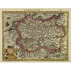
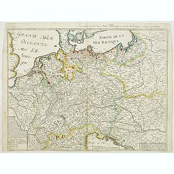
Germania.
Second state of this rare "carte à figures"- map of Germany, The Netherlands, Poland and central Europe. Bordered on three sides with portraits and views. In t...
Place & Date: Amsterdam, 1607
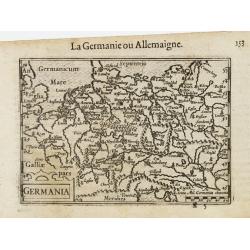
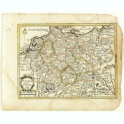
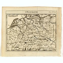
La Germanie.
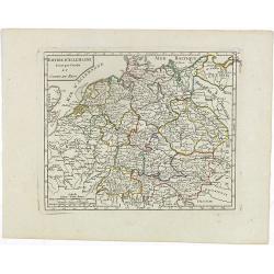
Small map of Germany, including Austria and part of Poland. Strap work title cartouche in the lower left.From the first French-text edition of Jodocus Hondius' Atlas Mino...
- $75 / ≈ €70
Place & Date: Amsterdam, 1608
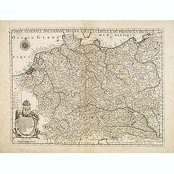
Germania.
A miniature map of Germany. The title cartouche on the lower left corner. First published in 1598 in his Caert-Thresoor, the plates were executed by the most famous engra...
- $75 / ≈ €70
Place & Date: Amsterdam/Frankfurt, 1609

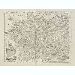
Nova Germaniae Descriptio..
A finely engraved carte à figures, with the side borders depicting emperors, while the upper and lower panels contain finely engraved miniature town prospects, among the...
Place & Date: Amsterdam, 1632
Carte Generalle de la Germanie.
A rare map of the whole Germany. Very decorative title cartouche on the lower left-hand corner.With the mention A Paris chez Nicolas Berey Enlumineur de la Reine, Demeura...
- $1000 / ≈ €936
Place & Date: Paris, 1638

Germaniae Nova ac Accurata Descriptio.
This "carte à figures"- map covers the Low Countries, Germany, Poland, Switzerland and Austria. Overall a very good copy of this excellently engraved, uncommon...
Place & Date: Amsterdam, 1642
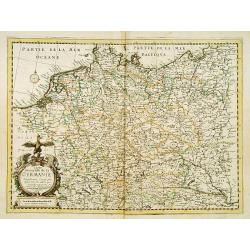
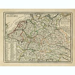
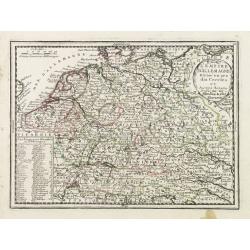
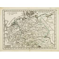
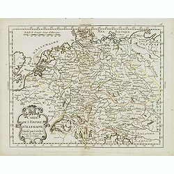
Carte generale de L'Empire d'Allemagne et pays circonvoisins. . .
Fine map of Germany, Low countries, Switzerland, Austria and Poland. The map was first published by Tavernier and later by Mariette. This edition carries the date 1642 an...
- $200 / ≈ €187
Place & Date: Paris, 1642/45-1657
Carte generalle d'allemaigne nouvellement misse en françois et Ampliffiée de tous les Royaumes. . .
Attractive and rare map of Germany, the Low Countries, Austria, Switzerland and part of Poland.
Place & Date: Paris, 1632-1660
Nouvelle Carte d'Allemagne 1651. (29).
Scarce map of Germany, Poland and the Low Countries, published by Antoine de Fer in 1661 or 1662 in "Cartes de géographie revues et augmentées". With number 2...
- $50 / ≈ €47
Place & Date: Paris, Antoine de Fer, 1657 but 1661 or 1662
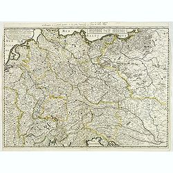
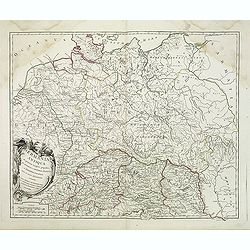
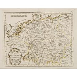
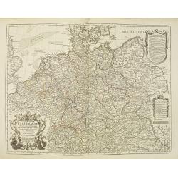
Carte générale d'Alemagne divisée par les cercles ou provinces d'icelle.
Rare and detailed map of Germany, Poland and Austria, engraved by H. le Roy in 1643 or 1666 for Jacques L'Agniet. The publishing house Jollain bought the copper plate and...
- $300 / ≈ €281
Place & Date: Paris, 1666

Carte de L'Empire d'Alemagne par P. Duval. . .
Uncommon map of Germany and the eastern part of Poland. In upper right corner a dedicational cartouche with coat of arms and dedication to Saint-Laurens.
Place & Date: Paris, 1676
Carte générale d'Alemagne divisée par les cercles ou provinces d'icelle.
Rare and detailed map of Germany, Poland and Austria, engraved by H. le Roy in 1643 or 1666 for Jacques L'Agniet. Published by François Jollain (ca. 1641 – 18 April 17...
- $450 / ≈ €421
Place & Date: Paris, 1689
L'Allemagne divisée en dix cercles . . .
An interesting small map of Germany and Poland by Nicolas de Fer. From his rare "Petit et Nouveau Atlas". The first edition was published in 1697 and was republ...
- $75 / ≈ €70
Place & Date: Paris, 1704
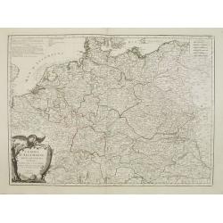
L'Empire D'Allemagne Divisé en ses dix Cercles et Autres Estats. . .
Map centered on Germany, including Poland, Switzerland, Austria, part of France, Northern Italy and Eastern Europe. With title cartouche and a panel in the lower left cor...
- $80 / ≈ €75
Place & Date: Paris, 1719
L'Empire D'Allemagne Divisé en ses dix Cercles et Autres Estats..
Map centered on Germany, including Switzerland, Austria, part of France, Northern Italy and Eastern Europe. With title cartouche and a panel in the lower left corner list...
- $60 / ≈ €56
Place & Date: Paris 1719
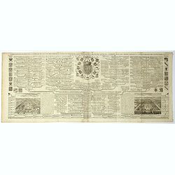
Carte genealogique de la famille Royale de Brunswick . .
A very detailed composite sheet with a genealogical table of the German royal families of Brunswick, Luneburg and Hanover, with descriptive French textZacharie Chatelain ...
- $50 / ≈ €47
Place & Date: Amsterdam, ca. 1720
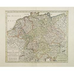
Nieuwe Kaart van Duitsland..
Detailed map of Germany, including The Netherlands, Belgium, Luxembourg, Switzerland and Austria. Isaac Tirion was born in Utrecht ca. 1705. He came to Amsterdam ca. 1725...
- $120 / ≈ €112
Place & Date: Amsterdam, 1747
L'Allemagne.
Scarce small map of Germany, Poland and Low Countries based on cartography of Guillaume Delisle (. Published in "Nouveau traité de geographie par M**** ", publ...
- $50 / ≈ €47
Place & Date: Paris, 1752
Germania Antiqua. . .
A fine map of ancient Germany, Poland and the Netherlands from his "Atlas Universel".Gilles Robert de Vaugondy (1688–1766), also known as Le Sieur or Monsieur...
- $50 / ≈ €47
Place & Date: Paris, 1756
L' Allemagne par Postes.
Fine map of Germany. George Louis Le Rouge was active from 1740 to 1780 as a publisher and was appointed engineer for the King of France. From his "Atlas Nouveau Por...
- $60 / ≈ €56
Place & Date: Paris 1756
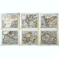
The Empire of Germany.
Uncommon miniature map in six sheets of the Empire of Germany, engraved by Thomas Kitching for "A New General and Universal Atlas Containing Forty five Maps by Andre...
- $75 / ≈ €70
Place & Date: London, 1761-1763
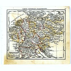
Empire of Germany.
Uncommon miniature map of Germany, Poland, the Low Countries and Eastern Europe, engraved by Thomas Kitching for "A New General and Universal Atlas Containing Forty ...
- $40 / ≈ €37
Place & Date: London, 1761-1763
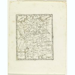
La Germania divisa ne' suoi differenti stati
Rare map of Germany, from "Atlante Novissimo ad uso Dei Giovani Studiosi Contenuto In Carte XXVII.", published by Giovanni Zempel in Rome, ca. 1780.The map is b...
- $25 / ≈ €23
Place & Date: Rome, 1780
Carte de l'Empire d'Allemagne Divisé par Cercles..
Rare map of Germany and the Low Countries prepared by J.B.Nolin and published by Monhare for his Atlas Général a l'usage des colleges et maisons d'education.Louis Josep...
- $100 / ≈ €94
Place & Date: Paris, 1783
Carte de l'Empire d' Allemagne . . .
Scarce map of Germany prepared by de la Fosse and published by L.J. Mondhare for his Atlas Général a l'usage des colleges et maisons d'education.. Louis Joseph Mondhare...
- $50 / ≈ €47
Place & Date: Paris, 1783
L'Empire d'Allemagne..
Detailed map encompassing Germany, the Netherlands, Belgium, Austria, and part of Poland.Venetian edition of the map by Bellin, to whom Santini gives credit in the cartou...
- $100 / ≈ €94
Place & Date: Venice, 1776 - 1784
L'Allemagne dressée sur les observations. . .
Map of Germany, Low Countries, Poland, Switzerland, Northern Italy. Prepared by G.De L'Isle after observations by Kepler and Tycho Brahe.Engraved by Jean Batiste Liébaux...
- $300 / ≈ €281
Place & Date: Paris, 1788
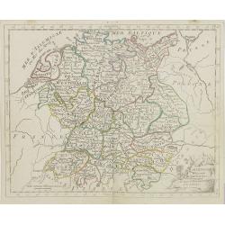
Empire d'Allemagne divisé par Cercles et Cours du Rhin.
Small detailed map of Germany, the Low Countries, Switzerland, Austria, Czechoslovakia and part of Poland.From Atlas Portatif Universel, by Robert de Vaugondy. Edited by ...
- $40 / ≈ €37
Place & Date: Paris, 1799
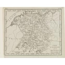
Carte d'Allemagne et de la Republique Helvetique.
Map of central Europe centered on Germany, extending southwards and eastwards to include Poland, the Czech Republic, Austria, Switzerland, Slovenia and part of Italy.From...
Place & Date: Paris, Prudhomme, Levrault, Debray, 1806
L'Allemagne . . .
Map of Germany, from Atlas moderne portatif composé de vingt-huit cartes sur toutes les parties du globe terrestre .. A l'usage des Colléges, des Pensions & des Mai...
- $50 / ≈ €47
Place & Date: Paris, Prudhomme, Levrault, Debray, 1806
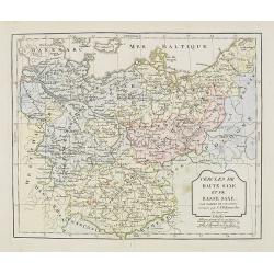
Cercle de Haute Saxe et de Basse Saxe. . .
Map of the duchies of Saxony (upper & lower). By C. F. Delamarche, successor of Robert de Vaugondy, Geographer.
- $50 / ≈ €47
Place & Date: Paris, 1794 - 1806
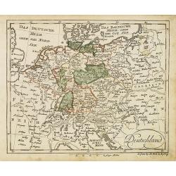
Deutschland (with Poland)
Nice small map of Germany by Johannes Walch in his rare Allgemeiner Atlas Nach den bewährsten Hülfsmitteln und astronomischen Ortsbestimungen…, edition of 1812.Johann...
- $75 / ≈ €70
Place & Date: Augsburg, 1812
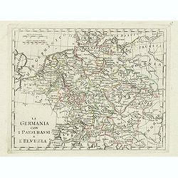
La germania con i paesi bassi e l'elvezia.
Charming map of Germany, Netherlands, Switzerland, Austria from the rare atlas Atlante Tascabile o sia Serie di Num. XXI Cartine Geografiche nelle quali si rappresenta in...
- $65 / ≈ €61
Place & Date: Rome, 1823
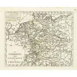
La germania con i Paesibassi e l'elvezia.
Charming map of Germany, The Netherlands, Switzerland and part of Poland from the rare atlas Atlante Tascabile o sia Serie di Num. XXI Cartine Geografiche nelle quali si ...
- $80 / ≈ €75
Place & Date: Rome, 1823
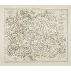
Allemagne . . .
Detailed map of Germany and Austria, prepared by A. H. Basset, rue Saint-Jacques, no. 64, Paris and published in Atlas classique et Universel de Géographie . . . .The en...
- $80 / ≈ €75
Place & Date: Paris, A.H. Basset, 1828
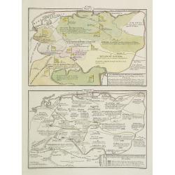
La Germania, suoi ducati e dependenze . . . /Origine e derivazione de principali stati . . .
Two rare maps of ancient Germany: Top map: 160 x 235mm. Bottom map: 160 x 235mm.Prepared by Las Casas for l'Atlante Storico, Letterario, Biografico, Archeologico. . . wi...
- $25 / ≈ €23
Place & Date: Venice, 1840
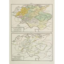
I dieci circoli Della Germania . . . / Permute e Secolarizzazioni Nella Germania . . .
Two rare maps of Germany: Top map: 160 x 235mm. Bottom map: 160 x 235mm.Prepared by Las Casas for l'Atlante Storico, Letterario, Biografico, Archeologico. . . with attri...
- $30 / ≈ €28
Place & Date: Venice, 1840
L'Alemagna . . .
A rare double-page map of Germany and Poland. Prepared by Las Casas and engraved by G.V.Pasquali for l'Atlante Storico, Letterario, Biografico, Archeologico. . . with at...
- $50 / ≈ €47
Place & Date: Venice, 1840
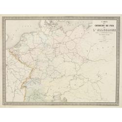
Carte des Chemins de Fer de l'Allemagne.
Fine map of Germany, The Netherlands and Eastern Europe, showing the early railway system of the area. From Atlas des Chemins de Fer published by Napoléon Chaix and pri...
Place & Date: Paris, 1863
Selling price: $2
Sold in 2011
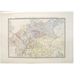
Nouvelle carte des routes de poste de l'Allemagne.
Large post road maps map of Germany, Poland, Austria, Franc, Switzerland, Austria and the Low Countries published by A. Logerot and engraved by C.Dyonnet.The mapsmakes di...
- $350 / ≈ €328
Place & Date: Paris, A. Logerot, c.1867

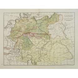
Wandkarte des Deutsches Reiches zum Schul und Comptoir-Gebrauch. . .
School wall map of Germany, Poland, Low Counties, Bohemia printed in chromo lithography with contemporary hand coloring to borders. Published by "Stich und Druck der...
Place & Date: Berlin, Dieter Reimer, 1878