Browse Listings in Europe > Eastern Europe > Hungary
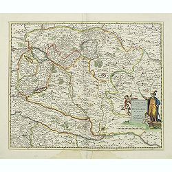
Novissima et accuratissima totius Hungariae tabula. . .
Detailed map of Hungary with a decorative title cartouche with putti and an Ottoman warrior. The publisher gives credit to P. du Val in the title cartouche.
Place & Date: Amsterdam, 1700
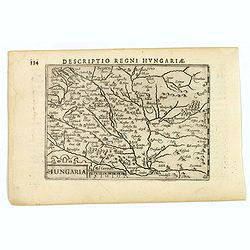
Hungaria.
A lovely miniature map of Hungary, published by Petrus Bertius, in Amsterdam at the beginning of the seventeenth century. There is a decorative strap-work title, and the ...
Place & Date: Amsterdam, 1606
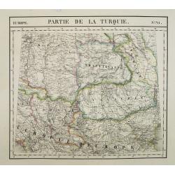
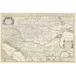
Europe. Partie de la Turquie. N°21.
Detailed map including Hungary and Romania.From his famous Atlas Universel . This atlas was one of the most remarkable world atlases ever produced, anticipating the Inter...
Place & Date: Brussels, 1825-1827
![[Portrait] - Me De Cet Corona se X+I. - Contantia et Fortudine](/uploads/cache/43510-250x250.jpg)
[Portrait] - Me De Cet Corona se X+I. - Contantia et Fortudine
Portrait of German Emperor Charles VI with his motto "Contantia et Fortudine". Holy Roman Emperor, 1711-1740, and King of Hungary as Charles III (1712-1740). Wi...
Place & Date: Germany, 1740
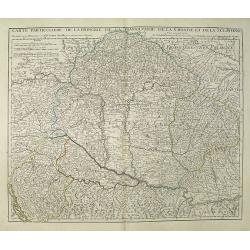
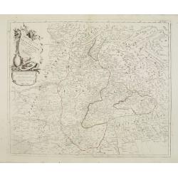
Carte Particuliere de la Hongrie de la Transilvanie de la Croatie et de la Sclavonie Dressée sur les Onservations de Mr. Le Comte Marsilli. . . Par G. Delisle.
Map of Hungary and Slovakia and adjacent parts of Croatia, Serbia and Romania (Transylvania). Prepared by Marsilli, published by Dezauche.
Place & Date: Paris, ca. 1780
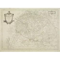
Le Royaume de Hongrie.
Fine oversized map of Hungary, but including Bosnia and Herzegovina, Bulgaria, Croatia, Romania, Albania, European part of Turkey, and Ukraine. With a decorative title an...
Place & Date: Amsterdam, 1692
Royaume de Hongrie.
Detailed map encompassing present day Hungary with the river Danube and the towns of Belgrade, Budapest, Vienna, etc.Venetian edition of the map by Bellin, to whom Santin...
Place & Date: Venice, 1776 - 1784
Principauté de Transilvanie et Pays circonvoisins..
Detailed map encompassing part of present-day Hungary.From "Atlas Universel" published by Santini in 1784. The atlas is effectively an Italian copy of the Rober...
Place & Date: Venice, 1784
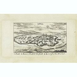
Gyula.
Panoramic view of Gyula in Békés County, Hungary. The town is best known for its Medieval castle and thermal bath. Published in "Der Donau-Strand Mit allen seinen ...
- $75 / ≈ €70
Place & Date: Nuremberg, Jacob Sandrart, 1684
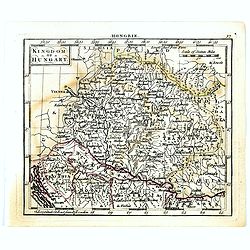
Kingdom of Hungary.
Uncommon miniature map of Hungary, engraved by Thomas Kitching for "A New General and Universal Atlas Containing Forty five Maps by Andrew Dury".This miniature ...
- $75 / ≈ €70
Place & Date: London, 1761-1763