Browse Listings in Europe > Eastern Europe > Balkans
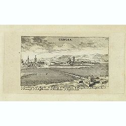
Comora.
Panoramic view of Comora. Published in "Der Donau-Strand Mit allen seinen Ein- und Zuflüssen. . .". Published by Jacob Sandrart.
- $100 / ≈ €94
Place & Date: Nuremberg, Jacob Sandrart, 1684
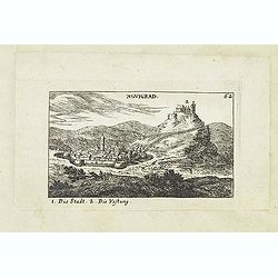
Novigrad.
Panoramic view of Nógrád in northern Hungary. Published in "Der Donau-Strand Mit allen seinen Ein- und Zuflüssen. . .". Published by Jacob Sandrart.
- $150 / ≈ €140
Place & Date: Nuremberg, Jacob Sandrart, 1684
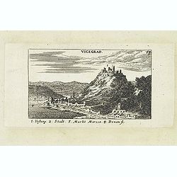
Vicegrad.
Panoramic view of Vicegrad. Published in "Der Donau-Strand Mit allen seinen Ein- und Zuflüssen. . .". Published by Jacob Sandrart.
- $100 / ≈ €94
Place & Date: Nuremberg, Jacob Sandrart, 1684
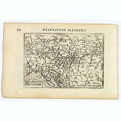
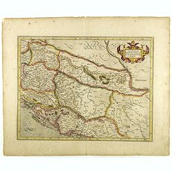
Illyricum.
A miniature map of Illyricum - it was the Roman province established in place of the former kingdom of Illyria. It stretched from the Drin river in modern Albania to Istr...
- $100 / ≈ €94
Place & Date: Amsterdam, 1606
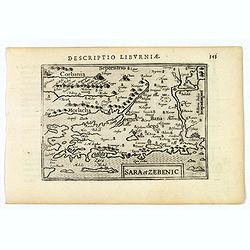
Sara et Zebenic.
A miniature map of Sara & Zebenic - in Croatia / Dalmatia in Eastern Europe, published by Petrus Bertius in Amsterdam, at the beginning of the seventeenth century. An...
- $100 / ≈ €94
Place & Date: Amsterdam, 1606
MEMORANDUM Vlade Demokratske Federativne Jugoslavije po pitanju Juliske Krajine i drugih jugoslavenskih teritorija pod Italijom.
Memorandum of the government of the Democratic Federative Yugoslavia concerning the questions of the Jilian March and other Yugoslav territories under Italy.Julian March ...
- $300 / ≈ €281
Place & Date: London, 1946
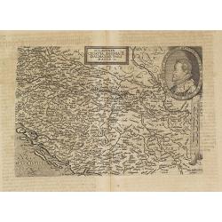
Sclavonia Croatia, Bosnia & Dalmatiae Pars Maior.
Mattheus Quadt's map of the western Balkan with a portrait of the Roma.Matthias Quadt (1557-1613) was a Dutch geographer who worked in Cologne. From "Geographisch ha...
- $500 / ≈ €468
Place & Date: Cologne, 1600
![Mer Adriatique. Côte Orientale. De l'Ile Meleda à Antivari.. [3552]](/uploads/cache/23471-250x250.jpg)
Mer Adriatique. Côte Orientale. De l'Ile Meleda à Antivari.. [3552]
This large scale coastal chart shows the stretch of Dalmatian coast between the island Mljet in Croatia as far as Ulcinj (Montenegro). With latitude and longitude scales,...
- $200 / ≈ €187
Place & Date: Paris [1877] corrected to 1934
![Mer Adriatique. Partie Sud.. [3976]](/uploads/cache/23549-250x250.jpg)
Mer Adriatique. Partie Sud.. [3976]
This large scale coastal chart centered on the southern part of the Adriatic sea. Showing the Dalmatian coast between Split in Croatia as far as the northernmost tip of C...
- $200 / ≈ €187
Place & Date: Paris [1883] updated for 1935
Sclavonia, Croatia, Bosnia cum Dalmatiae parte.
Nice map of the Eastern Balkans with the geographical & political divisions of Dalmatia, Croatia, Slavonia, Bosnia, Serbia, etc.Mercator was born in Rupelmonde in Fla...
- $250 / ≈ €234
Place & Date: Amsterdam, 1632