Browse Listings in Europe > British Isles > General
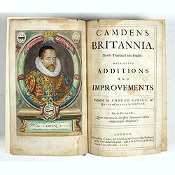
Camden's Britannia, Newly Translated into English with Large Additions and Improvements.
Splendid copy fully original colored (inclusive title-cartouche) of the first edition of Gibson's translation.Illustrated with an engraved portrait of Camden by R. White,...
Place & Date: London, F. Collins for A. Swalle and A. / J. Churchill, 1695
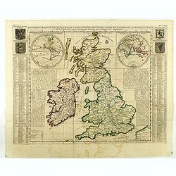
Nouvelle carte d'Angleterre, d'Ecosse et d'Irlande, avec des instructions ..
Striking large folding map of the British Isles, with large insets of the Eastern and Western Hemispheres and the coats of arms for England, Ireland, Scotland and Wales. ...
- $200 / ≈ €187
Place & Date: Amsterdam, 1721
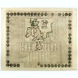
Carte Pour l'Introduction a l'Histoire d'Angleterre, ou l'on Voit son Premier Gouvernement, et l'Etat Abrege de cette Monarchie sous les Empereurs Romains, et sous les Rois Saxons.
The sheet includes a large inset map of Roman Britain including the English Channel and the western coast of France (200 x 255mm.). It also provides a wealth of informati...
- $200 / ≈ €187
Place & Date: Amsterdam, 1720
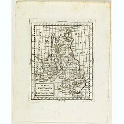
La Gran Bretagna ed isole Britanniche.
Rare map of Great Britain with Ireland, from "Atlante Novissimo ad uso Dei Giovani Studiosi Contenuto In Carte XXVII.", published by Giovanni Zempel in Rome, ca...
- $75 / ≈ €70
Place & Date: Rome, 1780
Angleterre Ecosse et Hibernie.
Rare map of the British islands, published by Jollain in 1667. Published in "Trésor Des Cartes Geographiques Des Principaux Estats de Lunivers".This atlas is b...
- $250 / ≈ €234
Place & Date: Paris, 1667
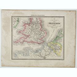
Le Vie Ferrate e Postali dell' Inchilterra . . .
Uncommon map of England and part of France prepared by Francesco Costantino Marmocchi. Above the map "Geografia Commerciale". From "Il Globo Atlante di car...
- $25 / ≈ €23
Place & Date: Genova, Paolo Rivara fu Giacomo, 1858
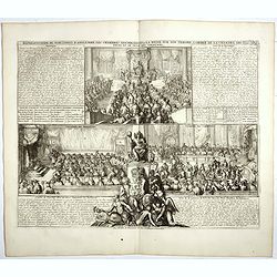
Représentation du parlement d'Angleterre, les chambres assemblées . . .
Engraving showing the British Parliament and an assembly before the King of England. From Chatelain's Atlas Historique, 1732-1739. In upper right margin: 'Tom. 7. No 26.H...
- $80 / ≈ €75
Place & Date: Amsterdam, 1720
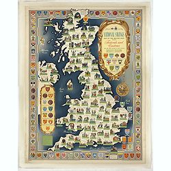
National saving map og the British Isles . . .
A brilliantly eccentric poster showing the festivals, customs of the British Isles with the arms and seals of the counties.Founded in 1861, National Savings is a state-ow...
- $450 / ≈ €421
Place & Date: London, 1951
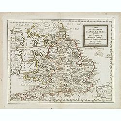
Carte du Royaume d'Angleterre. . .
Scarce map of England prepared by Nolin and published by L.J. Mondhare for his Atlas Général a l'usage des colleges et maisons d'education.Louis Joseph Mondhare was act...
- $100 / ≈ €94
Place & Date: Paris, 1783
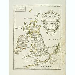
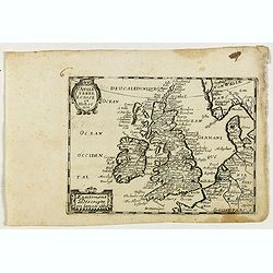
Carte des Isles Britanniques où sont les Royaumes d'Angleterre et d'Ecosse que nous appellons Grande Bretagne et celui d'Irlande avec les isles qui en sont proche . . .
General map of the British isles, with a fine title cartouche upper right with the date 1663 and the complete title reads : "Carte des Îles britanniques où se trou...
- $250 / ≈ €234
Place & Date: Paris, 1663