Browse Listings in Europe > British Isles > Channel Islands
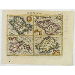
Anglesey Ins. / Wight.. / Ins. Garnesey. / Ins. Iarsey.
A reduced version of Mercator's folio map with four maps on one sheet depicting the English islands of Jersey, Guernsey, Wright and Alderney.Each map is embellished with ...
- $150 / ≈ €140
Place & Date: Amsterdam, 1608
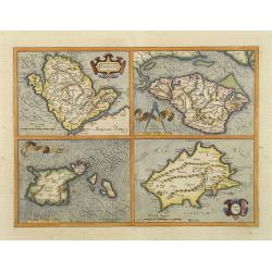
Anglesey. / Iarsay. / Carnesay. / Wight Vectis Olim.
Four maps on one sheet depicting the English islands Jersey, Guernsey, Wright and Alderney.
Place & Date: Amsterdam, 1629
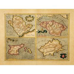
Anglesey. / Iarsay. / Carnesay. / Wight Vectis Olim.
Four maps on one sheet depicting the English islands Jersey, Guernsey, Wright and Alderney.
Place & Date: Amsterdam, 1630
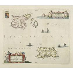
Sarnia Insula vulgo Garnsey et Insula Caesarea venacule Jarsey
Fine map depicting the English islands of Jersey and Guernsey is entitled : "Sarnica Insulavulgo Garnsey et Insula Caesarea vernacule Jarsey". In the cartouche...
- $475 / ≈ €444
Place & Date: Amsterdam, 1660

Het Canaal tusschen Engeland en Vranciick.
An eye-catching chart of the Channel.Pieter Goos (ca. 1616-1675) was one of the most important cartographers, engravers, publishers and print sellers of Amsterdam. His wi...
Place & Date: Amsterdam, after 1666

Carte de la Manche. . .
Decorative chart showing the Chanel, with the coastline of France from La Baie de Douarnenez to Dunkerque, and the coastline of England from Stroble head to Manning Tree....
Place & Date: Amsterdam, 1692
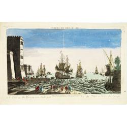
A view of the Gerzay near Iside part. / Vue du port et rade de Gerzay.
A fanciful depiction of the port of Jersey. Engraved by the French engraver Paul Angier after a design by P.Brookes and published by Robert Sayer of London, a well-known ...
Place & Date: London, ca. 1760

Nieuwe Paskaart van het Westerlykste Gedeelte van HET KANAAL strekkende aan de ENGELSCHE KUST van Poortland tot de Sorlinges. . .
Nieuwe Paskaart van het Westerlykste Gedeelte van HET KANAAL strekkende aan de ENGELSCHE KUST van Poortland tot de Sorlinges en aan de Fransche kust van het Eylandt Guern...
- $900 / ≈ €842
Place & Date: Amsterdam, 1760