Browse Listings in Europe > British Isles
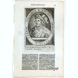
Eduardus Princeps Cambriae, Terror Gallorum.
The engraving depicts a half length oval portrait of Edward Prince of Wales. Nicolaes de Clerck (de Klerc) was active as engraver and publisher in Delft from 1599-1621.In...
- $25 / ≈ €23
Place & Date: Amsterdam, Cloppenburch, 1621
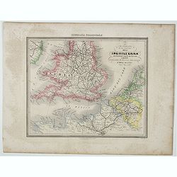
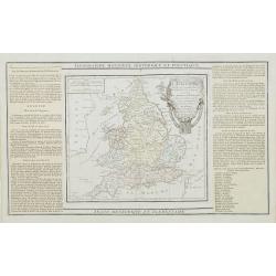
Le Vie Ferrate e Postali dell' Inchilterra . . .
Uncommon map of England and part of France prepared by Francesco Costantino Marmocchi. Above the map "Geografia Commerciale". From "Il Globo Atlante di car...
- $25 / ≈ €23
Place & Date: Genova, Paolo Rivara fu Giacomo, 1858
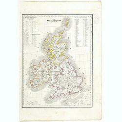
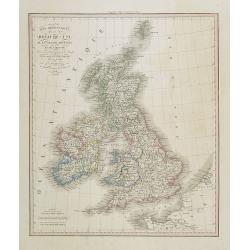
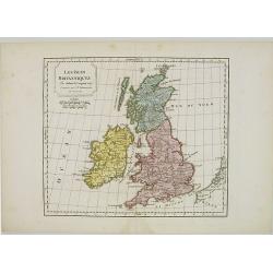
Iles Britanniques.
Detailed British Islands map, prepared by Charles V. Monin (fl.1830-1880) a French cartographer of Caen and Paris. Published in Atlas Universel de Géographie Ancienne &a...
- $25 / ≈ €23
Place & Date: Paris, 1845
![[The United Kingdom - Sweden, Norway, Denmark].](/uploads/cache/46169-250x250.jpg)
[The United Kingdom - Sweden, Norway, Denmark].
Alexey Afinogenovich Ilyin was a lieutenant general and cartographer (1832-1889). In 1856, after graduating from the Academy of the General Staff, he was at the military ...
- $50 / ≈ €47
Place & Date: St. Petersburg, 1899
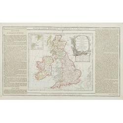
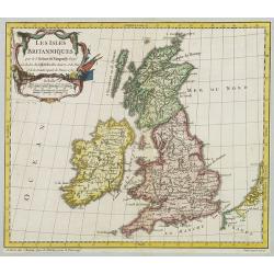
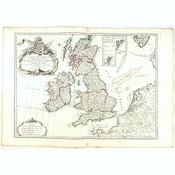
Les Isles Britanniques..
An attractive map of the British Isles including an inset of the Orkney and Shetland Islands. Finely embellished with a large title cartouche.The map is flanked by two co...
- $90 / ≈ €84
Place & Date: Paris, 1790
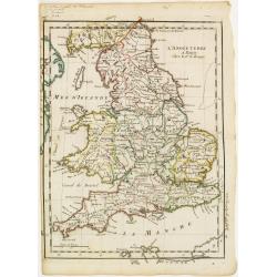
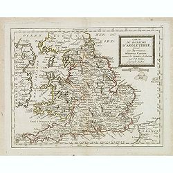
L'Angleterre divisée en 5 grandes Parties. . .
A very attractive map of England and Wales showing its 52 counties and the major cities as well as five large regional divisions.Finely embellished with a large title car...
- $100 / ≈ €94
Place & Date: Paris, 1790
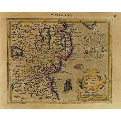
Ultonia Oriental.
Map depicting part of Ulster, with the south-western tip of Scotland in the upper right. From the first French-text edition of Jodocus Hondius' Atlas Minor.Shortly after ...
- $75 / ≈ €70
Place & Date: Amsterdam, 1608
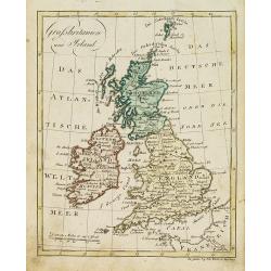
Grossbritanien und Irland.
Nice small map of the British isles and Ireland by Johannes Walch in his rare Allgemeiner Atlas Nach den bewährsten Hülfsmitteln und astronomischen Ortsbestimungen…, ...
- $50 / ≈ €47
Place & Date: Augsburg, 1812
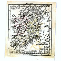
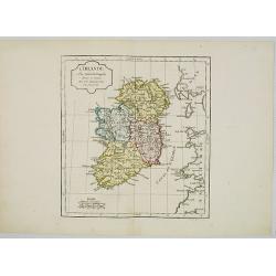
Ireland.
Uncommon miniature map of Ireland, engraved by J. Bayly for "A New General and Universal Atlas Containing Forty five Maps by Andrew Dury".This miniature atlas p...
- $50 / ≈ €47
Place & Date: London, 1761-1763
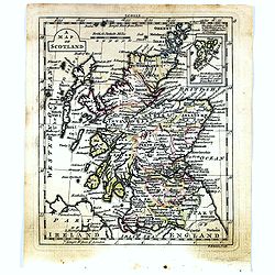
A map of Scotland.
Uncommon miniature map of Scotland, engraved by Thomas Kitching for "A New General and Universal Atlas Containing Forty five Maps by Andrew Dury".This miniature...
- $50 / ≈ €47
Place & Date: London, 1761-1763
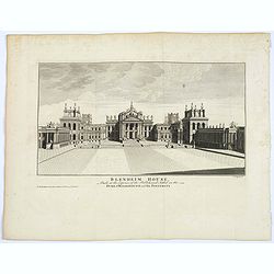
Blenheim House.
An attractive view of the front of Blenheim House (now Palace) home to the present 12th Duke and Duchess of Marlborough. The house was begun in 1705, built by Sir John Va...
- $50 / ≈ €47
Place & Date: London, ca. 1760
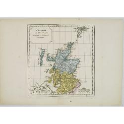
L' Ecosse.
Map of Scotland. By C. F. Delamarche, successor of Robert de Vaugondy, Geographer.
- $50 / ≈ €47
Place & Date: Paris, 1794 - 1806
Carte du gouvernement d'Angleterre où l'on représente l'Etat des officiers de Guerre. . .
Decorative map on the British Isles, with idyllic scenes showing councils of the various military officers of the British Isles. Henri Abraham Chatelain (1684 – 1743) w...
- $50 / ≈ €47
Place & Date: Amsterdam, 1720
Iles Britanniques ou Royaume-Uni de la Grande Bretagne . . .
Detailed map of United Kingdom, prepared by A. H. Basset, rue Saint-Jacques, no. 64, Paris and published in Atlas classique et Universel de Géographie . . . .The engrave...
- $90 / ≈ €84
Place & Date: Paris, A.H. Basset, 1828
Les Isles Britanniques ou sont les Royaumes . . .
An interesting small map of the British islands by Nicolas de Fer. From his rare "Petit et Nouveau Atlas". The first edition was published in 1697 and was repub...
- $75 / ≈ €70
Place & Date: Paris, 1705
Northumbr. Cumberladia Dunelm. Episcop.
A map of the most northern part of England, from the first French-text edition of Jodocus Hondius' Atlas Minor.Shortly after the publication of the big folio-atlases the ...
- $100 / ≈ €94
Place & Date: Amsterdam, 1608
L' Irlande.
Map of Ireland. By C. F. Delamarche, successor of Robert de Vaugondy, Geographer.
- $90 / ≈ €84
Place & Date: Paris, 1794 - 1806
Les Isles Britanniques.
Map of British Isles. By C. F. Delamarche, successor of Robert de Vaugondy, Geographer.
- $80 / ≈ €75
Place & Date: Paris, 1794 - 1806
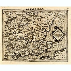
L'Angleterre.
Fine map of England and Wales. George Louis Le Rouge was active from 1740- till 1780 as a publisher, and was appointed engineer for the King of France. From his Atlas Nou...
Place & Date: Paris 1756
Carte du gouvernement militaire d'Angleterre où l'on représente l'état des officiers de guerre et celui des forces de terre et de mer.
Interesting sheet with a decorative map on the British Isles, with idyllic scenes showing councils of the various military officers of the British Isles, with descriptive...
Place & Date: Amsterdam, 1720
Warwicum Northampton, Huntingdon Cantabr etc.
Showing the south-eastern part of England. From his Atlas Minor. French text on verso.
- $100 / ≈ €94
Place & Date: Amsterdam, c.1630
Carte du Royaume d'Angleterre. . .
Scarce map of England prepared by Nolin and published by L.J. Mondhare for his Atlas Général a l'usage des colleges et maisons d'education.Louis Joseph Mondhare was act...
- $100 / ≈ €94
Place & Date: Paris, 1783
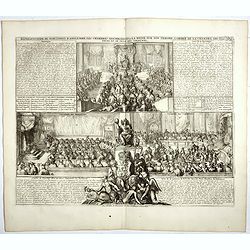
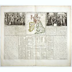
Représentation du parlement d'Angleterre, les chambres assemblées . . .
Engraving showing the British Parliament and an assembly before the King of England. From Chatelain's Atlas Historique, 1732-1739. In upper right margin: 'Tom. 7. No 26.H...
- $80 / ≈ €75
Place & Date: Amsterdam, 1720
![[L'Hermite's fleet moors in the Solent for repairs.]](/uploads/cache/40472-250x250.jpg)
[L'Hermite's fleet moors in the Solent for repairs.]
In March 1623, a heavily armed fleet of 11 ships, under the command of Jacob l’Hermite, sailed from Holland with the ambitious hope of ‘destroying the Spanish in Amer...
Place & Date: Frankfurt, M.Merian, 1633
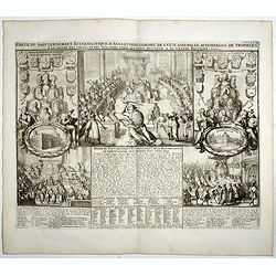
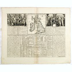
Carte du gouvernement ecclesiastique d'Angleterre . . .
Elegant engraving of the ecclesiastical government of England, with an engraving showing three images: in the centre, an ecclesiastical assembly (Convocation of the Clerg...
- $100 / ≈ €94
Place & Date: Amsterdam, 1720
Les Isles Britanniques..
A first state (of 2) dated 1762. Fine map of the British Isles, engraved by E.Dussy. Fine title cartouche upper left engraved by Arrivet. From his Nouvel Atlas Portatif .
Place & Date: Paris, 1762
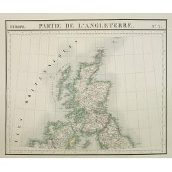
Europe. Partie de l'Angleterre. N°7.
Detailed map including Northern part of England.From his famous Atlas Universel . This atlas was one of the most remarkable world atlases ever produced, anticipating the ...
- $100 / ≈ €94
Place & Date: Brussels, 1825-1827
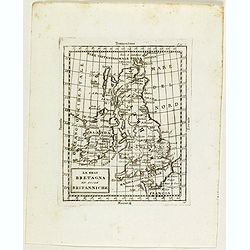
La Gran Bretagna ed isole Britanniche.
Rare map of Great Britain with Ireland, from "Atlante Novissimo ad uso Dei Giovani Studiosi Contenuto In Carte XXVII.", published by Giovanni Zempel in Rome, ca...
- $75 / ≈ €70
Place & Date: Rome, 1780

Udrone.
Map depicting present-day County Carlow in Leinster Province & Catherlaugh which is now Carlow. From the first French-text edition of Jodocus Hondius' Atlas Minor.Sho...
- $150 / ≈ €140
Place & Date: Amsterdam, 1608

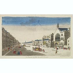
Vue de l Hotel du Lord Maire, qui comprend la Façade, et le Cot' Occidental de Londres.
Shows the famous Lord Mayor's coach driving through London. The Lord Mayor's coach is famous for its role in the Lord Mayor's Show, which is one of the longest establishe...
- $100 / ≈ €94
Place & Date: Augsburg, 1750
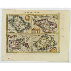
Anglesey Ins. / Wight.. / Ins. Garnesey. / Ins. Iarsey.
A reduced version of Mercator's folio map with four maps on one sheet depicting the English islands of Jersey, Guernsey, Wright and Alderney.Each map is embellished with ...
- $150 / ≈ €140
Place & Date: Amsterdam, 1608
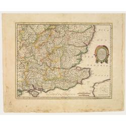
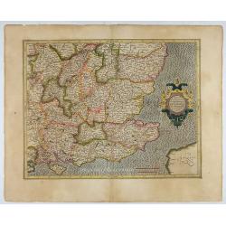
Warwicum Northamtonia Huntingdonia Cantabrigia..
Showing the south-eastern part of England.
Place & Date: Amsterdam, 1642
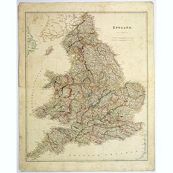
England.
A large and detailed steel engraved map of England, with each county divided by a different color. Many place names and physical features shown - it shows how densely pop...
Place & Date: London, 1839
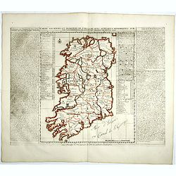
Carte ancienne et moderne de l'Irlande, avec quelques remarques sur son gouvernement . . .
Map of Ireland, based upon the ancient and modern cartographic information as of the beginning of the 18th Century. From Chatelain's monumental 7 volume "Atlas Histo...
- $200 / ≈ €187
Place & Date: Amsterdam, 1720
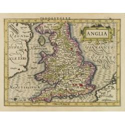
Anglia.
Map of England, from the first French-text edition of Jodocus Hondius'' Atlas Minor.Shortly after the publication of the big folio-atlases the need was apparently felt fo...
- $150 / ≈ €140
Place & Date: Amsterdam, 1608
Vue perspective du palais episcopal de Westminster.
So-called optical print illustrating a perspective view of the old Palace of Westminster where the Lords and Commons met and the square facing it.. Published by Jacques C...
- $150 / ≈ €140
Place & Date: Paris, ca. 1750
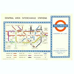
1953 Harry Beck London Underground map.
Published in the Queen's coronation year. A London Underground map (double sided).
- $150 / ≈ €140
Place & Date: London, 1953
Warwicum Northamtonia Huntingdonia Cantabrigia..
Showing the south-eastern part of England.
- $350 / ≈ €328
Place & Date: Amsterdam, 1630
Les Isles Britanniques Comprenant les Royaumes D'Angleterre, D'Ecosse et D'Irlande divisée en grands provinces. . .
Detailed map encompassing present day British Isles. An inset in the upper right details the Shetland and Orkney Islands. Venetian edition of the map by Janvier, to whom ...
- $200 / ≈ €187
Place & Date: Venice, 1776 - 1784
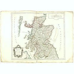
L'Ecosse divisée en Shires et Comtés.
Finely and crisply engraved map of Scotland.Venetian edition of Giles Didier Robert De Vaugondy's map from Atlas Universel printed in 1776-84.Ornamental title cartouche i...
- $250 / ≈ €234
Place & Date: Venice, 1776 - 1784