Search Listings matching "hondius" in Europe
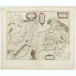
Veromanduorum.. Vermandois / Gouvernement de la Capelle.
A very decorative map with beautiful cartouches of a province of France by one of the most famous map publishers. Signed by Guilielmus Blaeu.From early on Willem Jansz. B...
- $220 / ≈ €188
Place & Date: Amsterdam, 1644
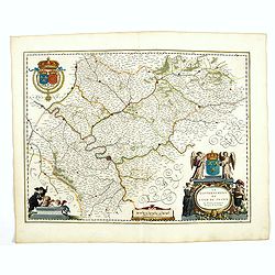
Le Gouvernement de l'Isle de France.
A very detailed map of Ile de France centered on Paris. Showing Beauvais, Compiègne, Noyon, Laon, Soisson, Vernon, Mante, Pontoise, Meaux, etc.Adorned with the royal arm...
- $300 / ≈ €256
Place & Date: Amsterdam, 1644
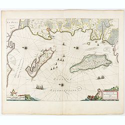
Insulae Divi Martini et Uliarus, vulgo L'Isle de Ré.. Oleron.
Map of Ré and Oléron islands. Depicting the west coast of France, showing La Rochelle. Several vessels and sailing ships dot the Atlantic ocean.Three windroses indicate...
- $950 / ≈ €812
Place & Date: Amsterdam, 1644
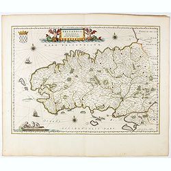
Britannia Ducatus. Duché de Bretaigne.
Map of Bretagne in France. From early on Willem Jansz. Blaeu aimed of publishing an atlas to compete with the Hondius-Jansson Atlas. By 1630, he had published at least 1...
- $650 / ≈ €556
Place & Date: Amsterdam, 1644
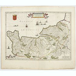
Normandia Ducatus.
Very detailed map of Normandy centered on Caen and Rouen. Also showing Cherbourg, Avranches, Bayeux, Cabourg, Honfleur, Le Havre, Etretat, Fecamp. St Malo and Mont Saint ...
- $400 / ≈ €342
Place & Date: Amsterdam, 1644
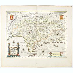
Andaluzia continens Sevillam.
Features the province of Andalucia and the city of Seville, but also depicts the Straights of Gibraltar, know in classical times as the Pillars of Hercules. Córdoba, Má...
- $350 / ≈ €299
Place & Date: Amsterdam, 1644
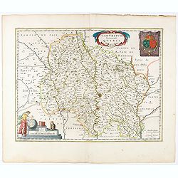
Cadurcium Vernaculé Querci.
Detailed map of a province of France by one of the most famous map publisher. Centered on Cahors.In the lower-left corner, a colored scale cartouche surmounted by a monke...
Place & Date: Amsterdam, 1644
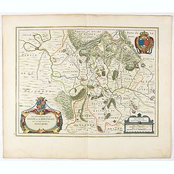
Xaintonge et Angoumois.
This map features a portion of western coastal France, north of Bordeaux with Ile de Ré and Ile Oléron. Two large cartouches show cherubs with grapes and wheat, and tw...
- $450 / ≈ €385
Place & Date: Amsterdam, 1644
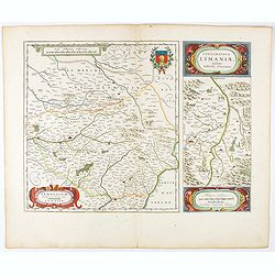
Lemovicum.. Lymosin. / Topographia Limaniae. . .
Two maps on one sheet. The author of the map of Lymosin was the French physician and cartographer Jean du Fayen. From early on Willem Jansz. Blaeu aimed of publishing an...
- $175 / ≈ €150
Place & Date: Amsterdam, 1644
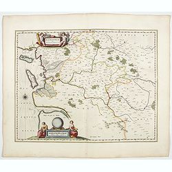
Territorium Metense. Auctore Ab. Fabert.. Le Pais Messin.
A very decorative map of part of Lorraine with beautiful cartouches. Orientated with West on top. Centered on Metz. From early on Willem Jansz. Blaeu aimed of publishing...
- $300 / ≈ €256
Place & Date: Amsterdam, 1644
Les Souverainetez de Sedan et de Raucourt.. Doncheri.
A very decorative map with beautiful large cartouches of a province of France by one of the most famous map publishers. From early on Willem Jansz. Blaeu aimed of publis...
- $175 / ≈ €150
Place & Date: Amsterdam, 1644
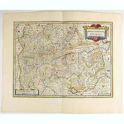
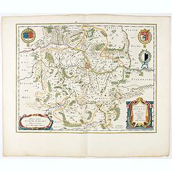
Monasteriensis Episcopatus.
A very detailed map of Germany centered on Linge. Showing Wessel to the top of the map, and Oldenburg to the right. North is oriented to the right. The map is further ado...
- $80 / ≈ €68
Place & Date: Amsterdam 1645
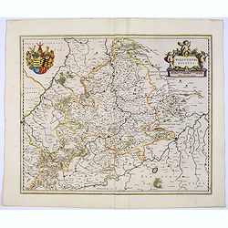
Archiepiscopatus Maghdeburgensis et Anhaltinus Ducatus.
A very nice, decorative copper engraved map of Lower-Saxony and Saxony-Anhalt by Blaeu. With one figural cartouche. Bounded on the west by the River Wesel between Nienbur...
- $80 / ≈ €68
Place & Date: Amsterdam, 1645
Wirtenberg Ducatus.
Map depicting the area south of Heidelberg, including Stuttgart, Ulm, etc.. and river Danube.A beautiful coat of arms and a splendid title cartouche decorated by three ch...
- $80 / ≈ €68
Place & Date: Amsterdam, 1645
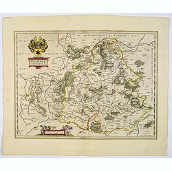
Waldeck Comitatus.
Blaeu's attractive map of the region of Waldeck. Forests, hills and rivers all feature, along with towns villages and cities. Decorative title cartouche surmounted by coa...
- $100 / ≈ €85
Place & Date: Amsterdam, 1645
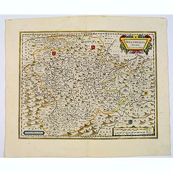
Westphalia Ducatus.
Originally engraved for Jodocus Hondius II, at his death in August 1629 this map was, among 39 other copper plates, purchased by Willem Blaeu who deleted Hondius' name an...
Place & Date: Amsterdam, 1645
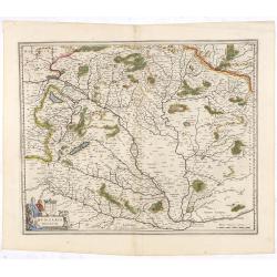
Hungaria Regnum.
Detailed map of Hungary centered on Budapest. Including the towns of Vienna, Zagreb as well.As Willem Blaeu died in 1638 most of his maps are actually published by his so...
Place & Date: Amsterdam, 1645
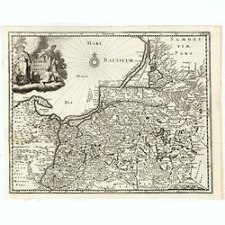
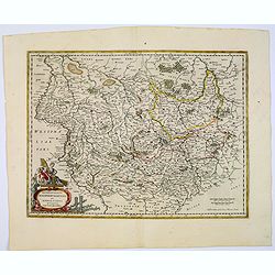
Prussiae nova tabula.
Rare map of Prussia with nowadays Poland. The map features a bold title cartouche, a ship, compass rose, and a sea monster in the Baltic Sea. The map was prepared by the ...
- $550 / ≈ €470
Place & Date: Amsterdam, 1647
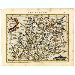
Ducatus Silesiae Glosani.
Charming map of the Silesia from the Mercator Hondius “Atlas Minor” published in Amsterdam in 1648 at Janssonius with German text on verso. Engraved by Petrus Kaerius...
- $200 / ≈ €171
Place & Date: Amsterdam, 1648
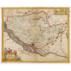
Tabula Geographica Novissima Ducatus Stormariae in Meridionali Parte Holsatiae.
A rare and beautiful map of the region of Germany around Hamburg. Fine detailed topography, including roads, fortifications, cities and villages. The title cartouche is s...
Place & Date: Amsterdam, 1681