Browse Listings in Celestials
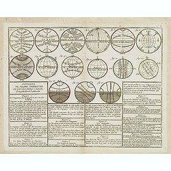
Divisions du Globe Terrestre en Cercles, Zônes, Climats, Longitudes et Latitudes.
A scarce print showing 15 globes, each globe showing different zones published by Mondhare for his Atlas Général a l'usage des colleges et maisons d'education.. Underne...
- $75 / ≈ €70
Place & Date: Paris, 1783

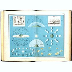
(3 pages from a instruction book)
3 charming pages with a terrestrial, celestial and an armillary globe and a small map of Saxony and Poland. Wind rose with smaller circular diagrams illustrating the theo...
- $125 / ≈ €117
Place & Date: Germany, ca. 1790
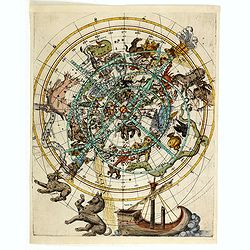
(Northern celestial planisphere with a pasted volvelle.)
Probably by the Vienna astronomer Melchior Klayber who used the Copernican precession theory, which is closely connected with the chart (Ptolemy - 6° 40' and Ptolemy - 5...
Place & Date: Vienna, ca. 1569
School atlas of astronomy: Comprising, in eighteen plates, a complete series of illustrations of the heavenly bodies. . .
An early edition of this fine Victorian celestial school atlas by Alexander Keith Johnston and edited by J.R. Hind. Illustrated with 18 decorative lithograph colored plat...
Place & Date: Edinburg, London, Blackwood and sons, 1855
![Planisphere celeste Septentrional. . . [together with] Planisphere celeste meridional. . .](/uploads/cache/35291-250x250.jpg)
Planisphere celeste Septentrional. . . [together with] Planisphere celeste meridional. . .
Beautiful set of celestial charts of the northern and southern skies by the well-known French astronomer, Philippe de La Hire. Surrounded by panels of astronomical notes ...
- $3000 / ≈ €2807
Place & Date: Paris, ca.1775
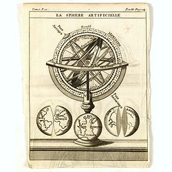
La Sphere Artificielle.
A diagram of an armillary sphere, with three illustrations of the Earth underneath. Published in "Nouveau traité de geographie par M**** ", published by La veu...
- $70 / ≈ €66
Place & Date: Paris, 1752
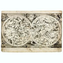
Hemel globe. / Coeli enarrant Gloriam del.
Charming double hemisphere celestial map on a polar projection. The map depicts the ecliptic pole to ecliptic, joined through winter solstice.It is based on the Hondius m...
- $500 / ≈ €468
Place & Date: Amsterdam, 1720
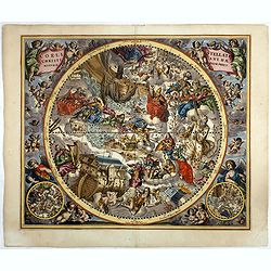
Coeli Stellati Christiani Haemisphaerium Prius.
Scarce first issue. This spectacular celestial chart presents the constellations according to Christian symbolism. The view of the constellations is based on the work of ...
Place & Date: Amsterdam, 1660
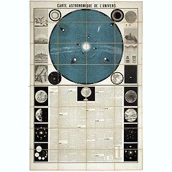
Carte Astronomique de L'Univers.
A large and decorative, informative chart illustrating and describing the Solar System, backed by the stars, printed in blue and black, surrounded by further 17 vignette ...
Place & Date: Paris, 1875
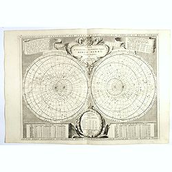
Planisferii Celesti, Calcolati Per L'Anno MDCC, Corretti, Et Aumenati Di Molte Stelle . . .
Double hemisphere celestial map showing a new and more scientific depiction of the heavens. The remarkable Vincenzo Coronelli (1650-1718), was a Franciscan Friar and appo...
- $1500 / ≈ €1404
Place & Date: Venice, 1700