Browse Listings
![[Java].](/uploads/cache/37965-250x250.jpg)
[Java].
Wood block engraved coastal profiles set in text from "Premier livre de l'histoire de la navigation aux Indes Orientales, par les hollandois, et des choses a eux adv...
- $20 / ≈ €19
Place & Date: Amsterdam, Cornille Nicolas, 1609
![[IX.] Carte du Brabant ou sont les Mairies de Roo, de Nivelle, de Hulpen, et de Geneppe.](/uploads/cache/24689-250x250.jpg)
[IX.] Carte du Brabant ou sont les Mairies de Roo, de Nivelle, de Hulpen, et de Geneppe.
Nice small map straddling the Flemish and the Walloon regions. It shows Halle, Nivelles, La Hulpe, Overijse, Genappe, etc.From Atlas Portatif Universel, by Robert de Vaug...
Place & Date: Paris, later than 1749

Homme-nord-est de l'Asie.
Originally hand-colored costume mezzotint of a man of Nord East Russia engraved by Félix Mixelle and Lachaussée Jeune after Jacques Grasset de Saint-Sauveur.As an etche...
- $25 / ≈ €23
Place & Date: Paris,1801-1806
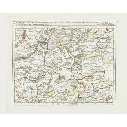
X. Carte du D.ché de Luxembourg.. Jametz &c.
Nice small map encompassing the northwestern part of Lorraine. Showing Mouzon, Stenay, Montmedy..From Atlas Portatif Universel, by Robert de Vaugondy. Edited by : "A...
Place & Date: Paris, later than 1749
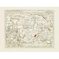
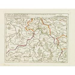
IX. Carte du D.ché du Luxembourg.. Diekirch &c.
Charming small map representing the area between Luxembourg and Trier. From Atlas Portatif Universel, by Robert de Vaugondy.Edited by : "Au dépôt de Géographie, R...
Place & Date: Paris, later than 1749
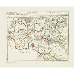
VII. Carte des Frontieres du Luxembourg.. Yvoix &c.
Detailed small map showing an area straddling the border between France and Belgium.From Atlas Portatif Universel, by Robert de Vaugondy. Edited by : "Au dépôt de ...
Place & Date: Paris, later than 1749
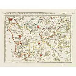
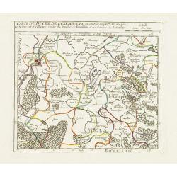
V. Carte du D.hé de Luxembourg.. dans le Lyegeois.
Charming small map representing part of Luxembourg, the southernmost province of Wallonia and of Belgium. Centered on Bastogne.From Atlas Portatif Universel, by Robert de...
Place & Date: Paris, later than 1749
IV. Carte du Duché de Luxembourg où sont les Seign.ries de Lompré..
Charming small map representing part of Luxembourg, the southernmost province of Wallonia and of Belgium.From Atlas Portatif Universel, by Robert de Vaugondy. Edited by :...
Place & Date: Paris, later than 1749
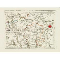
III. Carte du D.hé de Luxembourg.. Cronenburg &c.
Charming small map representing part of the Walloon Region, southeast to Limburg. From Atlas Portatif Universel, by Robert de Vaugondy.Edited by : "Au dépôt de Gé...
Place & Date: Paris, later than 1749
II. Carte du D.é de Luxembourg.. Seign.rie de Lyege &c.
Charming small map representing part of the Walloon Region, south to Liège. From Atlas Portatif Universel, by Robert de Vaugondy.Edited by : "Au dépôt de Géograp...
Place & Date: Paris, later than 1749
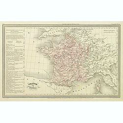
France par Provinces.
Finely engraved map prepared by A.H.Dufour and engraved by Giraldon-Bovinet. Published by Jules Renouard in his uncommon atlas "Le globe Atlas classique Universel de...
- $30 / ≈ €28
Place & Date: Paris, Jules Renouard, ca.1840
Le Marquisat et Electorat de Branderbourg.
Fine map of Brandenburg, with decorative title cartouche. George Louis Le Rouge was active from 1740- till 1780 as a publisher, and was appointed engineer for the King of...
- $30 / ≈ €28
Place & Date: Paris 1756
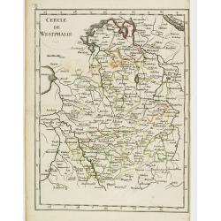
Cercle de Westphalie.
Fine map of North Rhine-Westphalia. George Louis Le Rouge was active from 1740 till 1780 as a publisher, and was appointed engineer for the King of France. From his Atlas...
- $30 / ≈ €28
Place & Date: Paris 1756
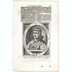
Fredeicus II. EXVL, Rex eapoltanus XXI.
The engraving depicts a half length oval portrait of "Fredericus II" and on the verso a portrait of "Ferdinandus V".Nicolaes de Clerck (de Klerc) was ...
- $20 / ≈ €19
Place & Date: Amsterdam, Cloppenburch, 1621
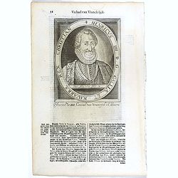
Henricus IIII. D. G. Galliae Et Navarrae Rex Christian.
The engraving depicts a half length oval portrait of Henry IV (1553 – 1610), also known by the epithet "Good King Henry", was King of Navarre (as Henry III) f...
- $25 / ≈ €23
Place & Date: Amsterdam, Cloppenburch, 1621
Ludovius XI. D. G. Galliae Rex Christianiss.
The engraving depicts a half length oval portrait of Louis XI of France.Nicolaes de Clerck (de Klerc) was active as engraver and publisher in Delft from 1599-1621.Include...
- $25 / ≈ €23
Place & Date: Amsterdam, Cloppenburch, 1621
Franciscus I. D. G. Galliarum Rex Christianissimus.
The engraving depicts a half length oval portrait of Francis I (François Ier) (1494 – 1547) was the first King of France from the Angoulême branch of the House of Val...
- $25 / ≈ €23
Place & Date: Amsterdam, Cloppenburch, 1621
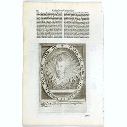
Maria De Medices D. G Galliae et Navarrae Reg. Uxor Henr. IIII.
The engraving depicts a half length oval portrait of Marie de' Medici, queen consort of France .Nicolaes de Clerck (de Klerc) was active as engraver and publisher in Delf...
- $15 / ≈ €14
Place & Date: Amsterdam, Cloppenburch, 1621
Lodovicus XIII. D. G. Galliae Et Navarrae Rex Christianiss.
The engraving depicts a half length oval portrait of Louis XIII of France.Nicolaes de Clerck (de Klerc) was active as engraver and publisher in Delft from 1599-1621.Inclu...
- $25 / ≈ €23
Place & Date: Amsterdam, Cloppenburch, 1621
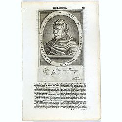
Leo X. Pontifex Maximus Florentinus Sedit Annos 8 Menses 8. / Paulus Quartus Neapolitanus Pontifex Maximus..
The engraving depicts a half length oval portrait of the Pope "Leo X", signed lower right corner N. de Cleck".On verso a half length oval portrait of "...
- $15 / ≈ €14
Place & Date: Amsterdam, Cloppenburch, 1621
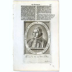
Adrians VI. Pontifex Maximus Ultraiectinus Vixit Annos 64 1/2.
The engraving depicts a half length oval portrait of Pope Adrian VI, born Adriaan Florensz (Boeyens) (1459 ? 1523), was born in the Prince-Bishopric of Utrecht in the Net...
- $25 / ≈ €23
Place & Date: Amsterdam, Cloppenburch, 1621
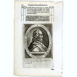
Carolus V D. G. Romanor Imperator Semper August.
The engraving depicts a half length oval portrait of Charles V (24 February 1500 – 21 September 1558) was ruler of both the Spanish Empire from 1516 and the Holy Roman ...
- $25 / ≈ €23
Place & Date: Amsterdam, Cloppenburch, 1621

Paris fashion plate. (607)
From Les Modes Parisiennes. Underneath the print are the names of the shops where the clothing's, perfumes, porcelains, flowers, etc., depicted in the engraving, are to b...
- $30 / ≈ €28
Place & Date: Paris, 1866
Carolus Magnus Romanorum Imperator Et Francorum Rex..
The engraving depicts a half length oval portrait of Charles the Great.Nicolaes de Clerck (de Klerc) was active as engraver and publisher in Delft from 1599-1621.Included...
- $20 / ≈ €19
Place & Date: Amsterdam, Cloppenburch, 1621
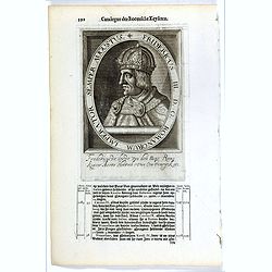
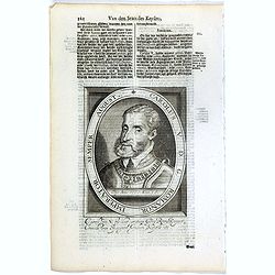
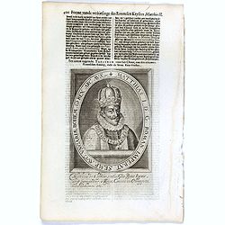
Fridericus III. D. G. Romanorum Imperator Semper Augustus.
The engraving depicts a half length oval portrait of Frederick III, Holy Roman Emperor.Nicolaes de Clerck (de Klerc) was active as engraver and publisher in Delft from 15...
- $20 / ≈ €19
Place & Date: Amsterdam, Cloppenburch, 1621
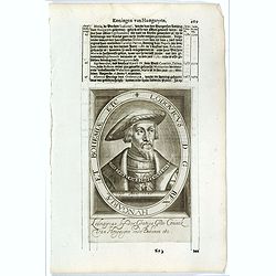
Matthias I. D. G. Roman. Imperat. Semp. Aug. Ungariae Bohem. & Rex. Arc. Aus. etc.
The engraving depicts a half length oval portrait of Matthias, Holy Roman Emperor from 1612, King of Hungary and Croatia from 1608 and King of Bohemia from 1611. He was a...
- $20 / ≈ €19
Place & Date: Amsterdam, Cloppenburch, 1621
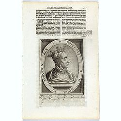
Lodovicus D.G. Rex Hungariae et Bohemiae Etc.
The engraving depicts a half length oval portrait of "Lodovicus D.G. Rex Hungariae et Bohemiae".Nicolaes de Clerck (de Klerc) was active as engraver and publish...
- $15 / ≈ €14
Place & Date: Amsterdam, Cloppenburch, 1621
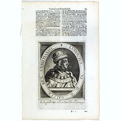
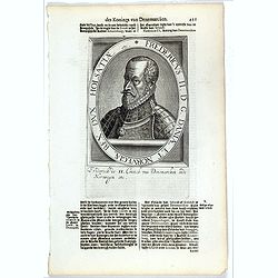
Fridericus I. D. G. Daniae Et Norvegiae Rex. etc.
The engraving depicts a half length oval portrait of "Fridericus I".Nicolaes de Clerck (de Klerc) was active as engraver and publisher in Delft from 1599-1621.I...
- $20 / ≈ €19
Place & Date: Amsterdam, Cloppenburch, 1621
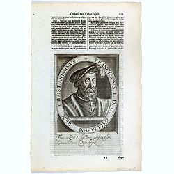
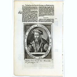
Fredericus II. D. G. Daniae Et Norvegiae Rex. Dux Holsatiae etc.
The engraving depicts a half length oval portrait of "Fredericus II".Nicolaes de Clerck (de Klerc) was active as engraver and publisher in Delft from 1599-1621....
- $20 / ≈ €19
Place & Date: Amsterdam, Cloppenburch, 1621
Christianus III. D. G. Daniae Et Norwegiae Rex. Dux Hols. etc.
The engraving depicts a half length oval portrait of "Christianus III".Nicolaes de Clerck (de Klerc) was active as engraver and publisher in Delft from 1599-162...
- $20 / ≈ €19
Place & Date: Amsterdam, Cloppenburch, 1621
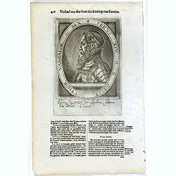
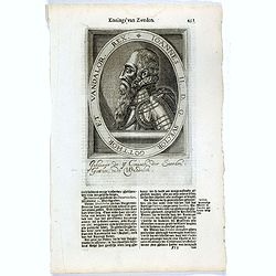
Ericus XIV. D G Sveciae, Gotthor. Vandalor. etc. Rex.
The engraving depicts a half length oval portrait of "Ericus XIV".Nicolaes de Clerck (de Klerc) was active as engraver and publisher in Delft from 1599-1621.Inc...
- $15 / ≈ €14
Place & Date: Amsterdam, Cloppenburch, 1621
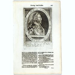
Carolus IX D G Sveciae Gotthorum Vandalorum etc. Rex.
The engraving depicts a half length oval portrait of "Carolus IX".Nicolaes de Clerck (de Klerc) was active as engraver and publisher in Delft from 1599-1621.Inc...
- $15 / ≈ €14
Place & Date: Amsterdam, Cloppenburch, 1621
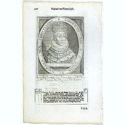
Ioannes II. D.G. Svecior. Gotthor. et Vandalor. Rex.
The engraving depicts a half length oval portrait of "Ioannes II".Nicolaes de Clerck (de Klerc) was active as engraver and publisher in Delft from 1599-1621.Inc...
- $15 / ≈ €14
Place & Date: Amsterdam, Cloppenburch, 1621
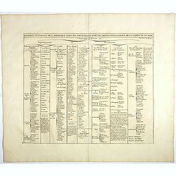
Division generale de l'Amerique dans ses principales parties pour l'intelligence de la carte de ce païs.
This folio sheet gives a breakdown of America into the northern and southern regions. These are further subdivided into the various countries and provinces.Henri Abraham ...
- $25 / ≈ €23
Place & Date: Amsterdam, 1728
Sewastopol. (Sebastopol)
View of Sebastopol. Engraved by Leopold Zechmayer who was active in Vienna.
- $20 / ≈ €19
Place & Date: Vienna, ca. 1835
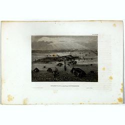
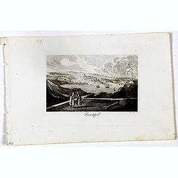
Kronstadt, in der ferne Petersburg.
Bird's eye view of Kronstadt, Russia's naval basis in front of Saint Petersburg. Original steel engraving published by Bibliographisches Institut Hildburghausen.
- $15 / ≈ €14
Place & Date: Hildburghausen, ca. 1860
![S. Victor in Franckr. [The Abbey of St. Victor near Paris.].](/uploads/cache/13769-250x250.jpg)
S. Victor in Franckr. [The Abbey of St. Victor near Paris.].
A very nice view of the Abbey of St. Victor near Paris. On the foreground, a night watchman is depicted. With a verse in two languages underneath the picture.The poet Dan...
- $60 / ≈ €56
Place & Date: Frankfurt, 1623-1678
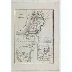
Carte de la Terre Sainte.
Detailed map of Israel, prepared by Charles V. Monin (fl.1830-1880) a French cartographer of Caen and Paris. Published in Atlas Universel de Géographie Ancienne &c M...
- $25 / ≈ €23
Place & Date: Paris, 1845
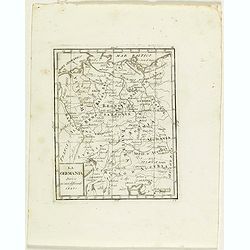
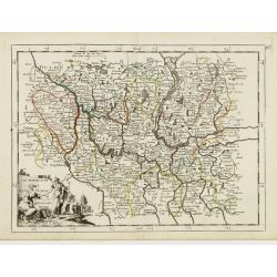
La Germania divisa ne' suoi differenti stati
Rare map of Germany, from "Atlante Novissimo ad uso Dei Giovani Studiosi Contenuto In Carte XXVII.", published by Giovanni Zempel in Rome, ca. 1780.The map is b...
- $25 / ≈ €23
Place & Date: Rome, 1780
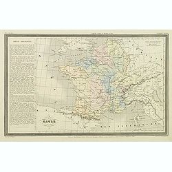
Gaule.
Finely engraved map prepared by A.H.Dufour and engraved by Giraldon-Bovinet. Published by Jules Renouard in his uncommon atlas "Le globe Atlas classique Universel de...
- $20 / ≈ €19
Place & Date: Paris, Jules Renouard, ca.1840
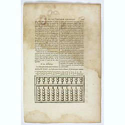
Souan pan, ou instrument dont les chinois se servent pour compter.
Text page with a wood block illustration of a souan-pan [suan-p'an] the calculation table used by the Chinese. Jean Baptiste Bourguignon d' Anville (1697-1782), French c...
- $20 / ≈ €19
Place & Date: Paris, P.G. Le Mercier, 1735
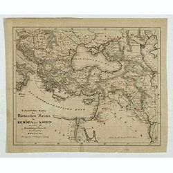
Karte des Türkischen Reiches in Europa und Asien . . .
Map of Turkish Empire.
- $35 / ≈ €33
Place & Date: Breslau, 1878
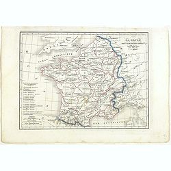
La Gaule sous l'Empire Romain.
Detailed map of France, prepared by Charles V. Monin (fl.1830-1880) a French cartographer of Caen and Paris. Published in Atlas Universel de Géographie Ancienne &c M...
- $25 / ≈ €23
Place & Date: Paris, 1845
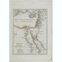
Egypte, Palestine, Syrie et Phoenicie.
Detailed map of Egypt, Palestine, Syria and Phoenicia, prepared by Charles V. Monin (fl.1830-1880) a French cartographer of Caen and Paris. Published in Atlas Universel d...
- $25 / ≈ €23
Place & Date: Paris, 1845
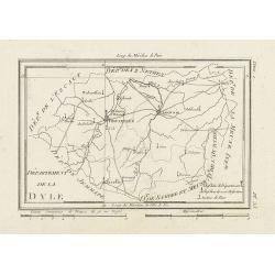
Département de la Dyle.
Map centered on Bruxelles with a short key list in the lower right corner. From Atlas de la Géographie de toutes les parties du monde .. Ouvrage destiné pour l'educatio...
- $40 / ≈ €37
Place & Date: Paris, Prudhomme, Levrault, Debray, 1806
![Homme de Tobolsk [together with] Femme Fatar Tobolsk.](/uploads/cache/36939-250x250.jpg)
Homme de Tobolsk [together with] Femme Fatar Tobolsk.
Set of two originally hand-colored mezzotints of Native Russians engraved by Félix Mixelle and Lachaussée Jeune after Jacques Grasset de Saint-Sauveur.As an etcher, dra...
- $50 / ≈ €47
Place & Date: Paris,1801-1806
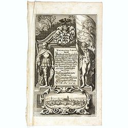
Title page : Topographia Sueviae dasist . . .
Title page from Casper Merian's Topographia Suevia..
- $50 / ≈ €47
Place & Date: Frankfurt, 1643
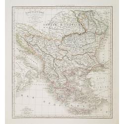
Turquie d'Europe . . .
Detailed map of Grrece, Marcedonia, Bulgaria, Servia, Roumania, prepared by A. H. Basset, rue Saint-Jacques, no. 64, Paris and published in Atlas classique et Universel d...
- $80 / ≈ €75
Place & Date: Paris, A.H. Basset, 1828
![Femme Baschkir [together with] Homme Baschkir.](/uploads/cache/36933-250x250.jpg)
Femme Baschkir [together with] Homme Baschkir.
Set of two originally hand-colored mezzotints of Native Russians engraved by Félix Mixelle and Lachaussée Jeune after Jacques Grasset de Saint-Sauveur.As an etcher, dra...
- $50 / ≈ €47
Place & Date: Paris,1801-1806
![Fille Mordwine en habits de nôces [together with] Fille Mordwine.](/uploads/cache/36932-250x250.jpg)
Fille Mordwine en habits de nôces [together with] Fille Mordwine.
Set of two originally hand-colored mezzotints of Native Russians engraved by Félix Mixelle and Lachaussée Jeune after Jacques Grasset de Saint-Sauveur.As an etcher, dra...
- $50 / ≈ €47
Place & Date: Paris,1801-1806
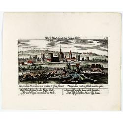
St. Cruis ( in eastern Poland.)
A very nice view of Kloster Heiligkreuz (Swiety Krzyz), in eastern Poland. In the foreground, a man climbing up a column is depicted. With a verse in two languages undern...
- $120 / ≈ €112
Place & Date: Frankfurt, 1623-1778
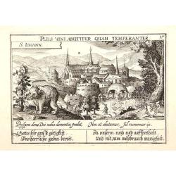
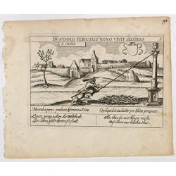
S. Iohann. Plus vini abutitur quam temperanter.
A very nice view of S.Johann Kloster with in the foreground, a wolf eating grapes. The Abbey of Saint John is an ancient Benedictine monastery in the Swiss municipality o...
- $70 / ≈ €66
Place & Date: Frankfurt, 1623-1678
Vincennes - Viel hund Feind.des Hasen Todt.
A very nice picture representing Vincennes. With a verse in German and Latin. The German text reads : "Viel Hundt feind ja des Hasen Todr, Ihr viel bringn einen bald...
- $70 / ≈ €66
Place & Date: Frankfurt, 1623-1678
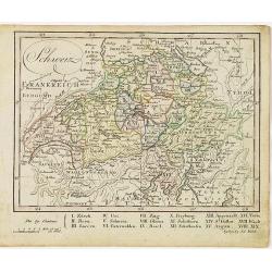
Schweiz.
Nice small map of Switzerland by Johannes Walch in his rare Allgemeiner Atlas Nach den bewährsten Hülfsmitteln und astronomischen Ortsbestimungen…, edition of 1812.Jo...
- $60 / ≈ €56
Place & Date: Augsburg, 1812
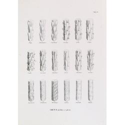
ABIETUM phyllulae et pulvini.s. Tab. 137.
From his famous work 'Flora Japonica'. Von Siebold was born in Würtzburg, in Germany, and worked for the Dutch government as a doctor in Java. In Japan, where Von Siebol...
- $75 / ≈ €70
Place & Date: Leiden, 1852
![S. Victor in Franckr. [Paris].](/uploads/cache/13781-250x250.jpg)
S. Victor in Franckr. [Paris].
A very nice view of St. Victor church in Paris. In the foreground, a night watchman is depicted. With a verse in Latin and German underneath the picture. The German text ...
- $60 / ≈ €56
Place & Date: Frankfurt, 1623-1678
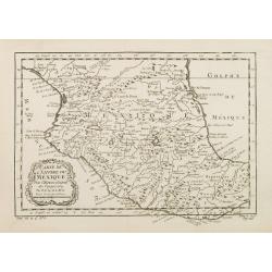
Carte de L'Empire du Mexico.
A good engraved map of Mexico, with rococo title cartouche lower left. From l'Histoire générale des voyages .
- $75 / ≈ €70
Place & Date: Paris, 1754
Populorum Germaniae . . .
Two maps of historical Germany on a single sheet. The two maps appear identical at first glance, but actually are a comparison of the region during the reigns of differen...
- $50 / ≈ €47
Place & Date: Amsterdam, 1661
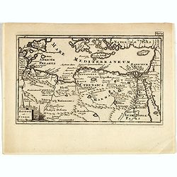
Aegyptus Et Cyrene.
A fine coastal region of Libya, also known as Pentapolis in antiquity. From "Introductio in Universam Geographicam" and edited by Johann Friedrich Heckel Philli...
- $50 / ≈ €47
Place & Date: London, 1697
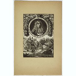
D. Gregoire Caraffe G. M. de Malte. M.C.D.LXXXI.
Portrait of Gregorio Carafa (1615 - 1690), 62nd Prince and Grand Master of the Order of Saint John (Knights of Malta) 1680 until his death in 1690.The sea battle undernea...
- $30 / ≈ €28
Place & Date: Paris, Denys Thierry, 1683
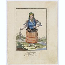
Une Kabardinienne.
Uncommon copper engraved costume plate from the French translation of Johann Gottlieb Georgi "Beschreibung aller Nationen des Russischen Reichs" (1776), the wor...
- $50 / ≈ €47
Place & Date: St. Petersbourg, C.G. Müller, 1776-1777
Le Vie Ferrate e le Strade Postali della Germania orientale . . .
Uncommon map of Germany and part of Poland, Hungary and Italy prepared by Francesco Costantino Marmocchi. Above the map "Geografia Commerciale". From "Il G...
- $25 / ≈ €23
Place & Date: Genova, Paolo Rivara fu Giacomo, 1858
![[Title page] La France Nouvel Atlas illustré des Départements & des Colonies . . .](/uploads/cache/17248-250x250.jpg)
[Title page] La France Nouvel Atlas illustré des Départements & des Colonies . . .
Title page from a French atlas, the decoration executed in Neo-Gothic style. In bottom part a globe and a map of France, to the left an Atlas-figure.Engraved by Villerey.
- $30 / ≈ €28
Place & Date: Paris, 1880
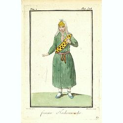
Femme Tschouwache.
Originally hand-colored mezzotint from 'Costumes civils actuels de tous les peuples connus' engraved by Félix Mixelle and Lachaussée Jeune after Jacques Grasset de Sain...
- $30 / ≈ €28
Place & Date: M. Sylvain Maréchal. Paris, 1788
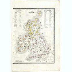
Iles Britanniques.
Detailed British Islands map, prepared by Charles V. Monin (fl.1830-1880) a French cartographer of Caen and Paris. Published in Atlas Universel de Géographie Ancienne &a...
- $25 / ≈ €23
Place & Date: Paris, 1845
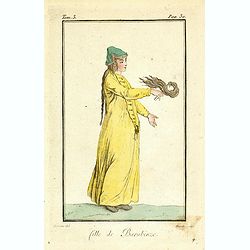
Fille de Barabinze.
Originally hand-colored mezzotint from 'Costumes civils actuels de tous les peuples connus', showing a girl from Barabinze in Siberia, Russia engraved by Félix Mixelle a...
- $30 / ≈ €28
Place & Date: M. Sylvain Maréchal. Paris, 1788
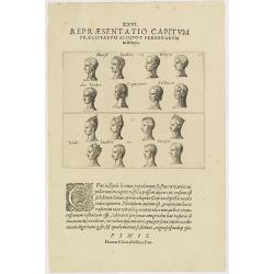
XXVI. Repraesentatio Capitum Praecipuarum Aliquot Personarum in Benyn.
Different types from Benin, in West Africa.Theodore de Bry, a German engraver and book dealer, began a compilation of early voyages in 1590 and had published six parts at...
- $75 / ≈ €70
Place & Date: Frankfurt, 1609
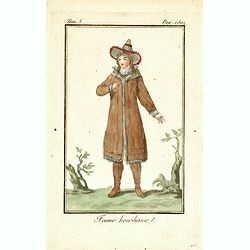
Femme Kourilienne.
Originally hand-colored mezzotint of a native Kourilles lady engraved by Félix Mixelle and Lachaussée Jeune after Jacques Grasset de Saint-Sauveur. From 'Costumes civil...
- $25 / ≈ €23
Place & Date: Paris,1801-1806

Paris fashion plate. (115)
From Les Modes Parisiennes. Underneath the print are the names of the shops where the clothing's, perfumes, porcelains, flowers, etc., depicted in the engraving, are to b...
- $30 / ≈ €28
Place & Date: Paris 1870
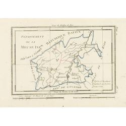
Département de la Meuse Inf.re.
Map representing the area around Maastricht, with a short key list in the lower right corner.From Atlas de la Géographie de toutes les parties du monde .. Ouvrage destin...
- $40 / ≈ €37
Place & Date: Paris, Prudhomme, Levrault, Debray, 1806
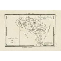
Département de Jemmape.
Map representing the area around Mons, with a short key list in the lower right corner.From Atlas de la Géographie de toutes les parties du monde .. Ouvrage destiné pou...
- $30 / ≈ €28
Place & Date: Paris, Prudhomme, Levrault, Debray, 1806
![Cordelirs in Franckr. [France].](/uploads/cache/13811-250x250.jpg)
Cordelirs in Franckr. [France].
A panoramic view of the town of Cordelirs (probably imaginary) with in center the church. On the foreground a man hunting a wolve. With a verse in two languages underneat...
- $35 / ≈ €33
Place & Date: Frankfurt 1623-1678
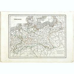
Prusse.
Detailed map of Prussia, prepared by Charles V. Monin (fl.1830-1880) a French cartographer of Caen and Paris. Published in Atlas Universel de Géographie Ancienne &c ...
- $40 / ≈ €37
Place & Date: Paris, 1845
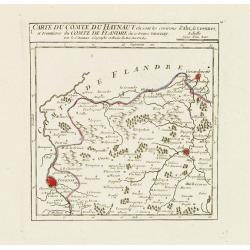
I. Carte du Comté du Haynaut.. Tournay.
Attractive small map encompassing part of Hainaut, between Tournai and Ath. From Atlas Portatif Universel, by Robert de Vaugondy.Edited by : "Au dépôt de Géograph...
- $40 / ≈ €37
Place & Date: Paris, 1799
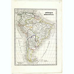
Amérique méridionale.
Detailed map of South America, prepared by Charles V. Monin (fl.1830-1880) a French cartographer of Caen and Paris. Published in Atlas Universel de Géographie Ancienne &...
- $45 / ≈ €42
Place & Date: Paris, 1845
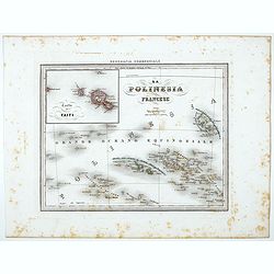
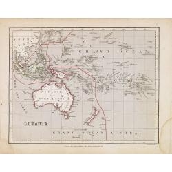
La Polinesia Francese.
Uncommon map of French Polynesia prepared by Francesco Costantino Marmocchi. Above the map "Geografia Commerciale". From "Il Globo Atlante di carte Geograf...
Place & Date: Genova, Paolo Rivara fu Giacomo, 1858
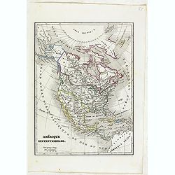
Amérique Septentrionale.
Detailed map of America, prepared by Charles V. Monin (fl.1830-1880) a French cartographer of Caen and Paris. Published in Atlas Universel de Géographie Ancienne &c ...
- $50 / ≈ €47
Place & Date: Paris, 1845

The attempt on the Czar's life: the Soltykoff dorway of the Winter Palace . . .
A panorama of the Winter Palace published in the Illustrated London News of 1880.
- $20 / ≈ €19
Place & Date: London, 28 February, 1880
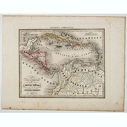
Le Indie Ocidentali ( Antille maggiori e minori, ecc) L'America Centrale . . .
Uncommon map of Central America and the Antilles prepared by Francesco Costantino Marmocchi. Above the map "Geografia Commerciale". From "Il Globo Atlante ...
Place & Date: Genova, Paolo Rivara fu Giacomo, 1858