Browse Listings in Australia & Oceania > Australia
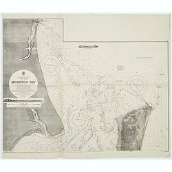
Australia, E. coast - Queensland Moreton Bay
Large chart representing East coast of Australia with Moreton Bay in Queensland.After a survey by Comr. J.Jeffery, etc. in 1865. New edition at the Admiralty 1870. With ...
Place & Date: London, 1882-1945
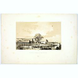
Pecheurs de Tripang a la Baie Raffles.
Fine lithograph of Javanese fishermen in the Bay of Raffles. Located at the eastern end of the Cobourg Peninsula, Raffles Bay was the site of the second abortive attempt ...
Place & Date: Paris, 1842
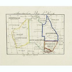
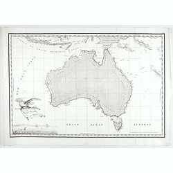
Australia by P.Rivett.
Manuscript map of Australia without Tasmania, prepared by Palmer Rivett, who was born around 1858 in Blundeston, Suffolk, England, where he spent most of his life. He was...
Place & Date: c. 1860-1870

Paskaerte Zynde t'Oosterdeel Van Oost Indien, met alle de Eylanden daer ontrendt geleegen van C. Comorin tota aen Iapan.
An eye-catching chart of Pieter Goos' sea chart of Australia, Southeast Asia, China, Japan, Korea and India. The chart shows the regions from Cape Comorin (Southern India...
Place & Date: Amsterdam, 1669
![Nouvelle-Hollande. Oui-Re-Kine. [plate XXI]](/uploads/cache/40110-250x250.jpg)
Nouvelle-Hollande. Oui-Re-Kine. [plate XXI]
A portrait of a female aboriginal residing in Sydney.After the original sketches by Lesueur, from Voyage de découvertes aux terres Australes by François Péron, 1824.Th...
- $100 / ≈ €94
Place & Date: Paris, 1824
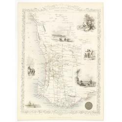
Western Australia. Swan River.
Decorative steel engraved map of part of Western Australia and Swan River, surrounded by illustrations of Perth, Aborigines and sheep shearing. With the seal of Western A...
- $300 / ≈ €281
Place & Date: London, ca. 1851
![Nouvelle-Hollande: Nouvelle Galles du Sud. Navigation. [plate XXIII]](/uploads/cache/40112-250x250.jpg)
Nouvelle-Hollande: Nouvelle Galles du Sud. Navigation. [plate XXIII]
Aboriginal boats, used for hunting and water transportationAfter the original sketches by Lesueur, from Voyage de découvertes aux terres Australes by François Péron, 1...
- $100 / ≈ €94
Place & Date: Paris, 1824
![Phisique. [plate XL]](/uploads/cache/40124-250x250.jpg)
Phisique. [plate XL]
Some scientific instruments for measuring the sea temperature at some depth. From Voyage de découvertes aux terres Australes by François Péron, 1824.The French expedit...
- $40 / ≈ €37
Place & Date: Paris, 1824
![Plan des Iles Jérôme [with] Plan des Iles Berthier [with] Plan du Comté de Cumberland.](/uploads/cache/46370-250x250.jpg)
Plan des Iles Jérôme [with] Plan des Iles Berthier [with] Plan du Comté de Cumberland.
Three maps on one sheet, Jérôme islands, Berthier islands and Cumberland county, from Voyage de découvertes aux terres Australes by François Péron, 1824. The French ...
- $100 / ≈ €94
Place & Date: Paris, 1807-1816
Carte Generale de la Nouvelle Hollande.
Fine map of the continent of Australia prepared by Louis Freycinet during his voyage under Captain Thomas Baudin in 1800-1803. Freycinet's map of New Holland was the firs...
- $5000 / ≈ €4679
Place & Date: Paris, Imprimerie Royale, 1811