Browse Listings in Asia > Thailand / Burma / Vietnam
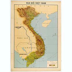
Dia-Do Viet-Nam.
Economic map of Vietnam published in 1960 (not for sale), gift from Japan paper committee. Scale : 1:2 400 000. With a key at lower right part.Features Vietnam, Cambodia,...
Place & Date: 1960
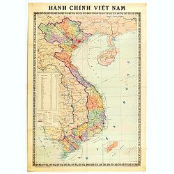
Hành Chính Việt Nam.
Uncommon map of Vietnam published in 1976, one year after the end of the Vietnam War. In April 1976, the National Assembly decided to reiterate Hanoi as the capital of th...
Place & Date: Hanoï, 1976
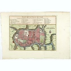
Plan de la ville de Siam.
Early plan of Siam, Thailand. Across the top is an extensive list of 22 important sites and locations keyed to the plan with tiny letters and numbers.Jacques Nicolaas Bel...
- $400 / ≈ €374
Place & Date: Paris, 1750

XVII. Proditorum in Pegu Supplicium.
Human torture in Pegu, now Myanmar. After his stay in the Indian city of Goa, Van Linschoten set out for Europe with a Portuguese return fleet in 1588. One of the ships w...
- $75 / ≈ €70
Place & Date: Frankfurt, 1599

XVI. Magnificentiae Regis In Pegu, et Quomodo. . .
A scene in the kingdom of Pegu, now Myanmar, shows elephants, ships, and locals. Theodore de Bry, a German engraver and book dealer, began a compilation of early voyages ...
- $75 / ≈ €70
Place & Date: Frankfurt, 1599

XV. Ratio Homines Ex Uno Loco In alium gestandi.
Scene in the kingdom of Pegu, now Myanmar, showing elephant, ships and locals.Theodore de Bry, a German engraver and book dealer, began a compilation of early voyages in ...
- $75 / ≈ €70
Place & Date: Frankfurt, 1599
Mer de Chine. Golfe du Tonkin. Entrées de Kuaï-Chin-Mun et Tsieng-Mun. . .
Large chart centred on the Gulf of Tonkin in the South China Sea. Showing banks, isles and soundings made in metres. Relief is shown by hachures.Engraved by A. Gérin aft...
Place & Date: Paris, 1887
Selling price: $300
Sold in 2008
![[US Army map of a part of Vietnam.]](/uploads/cache/44790-250x250.jpg)
[US Army map of a part of Vietnam.]
A large aerial US Army map of a portion of Vietnam, taken during the war between the two countries. As you might expect the map is highly detailed, highlighting settlemen...
- $150 / ≈ €140
Place & Date: Washington D.C., 1967
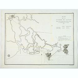
Plan de la Riviere de Saigon depuis le cap St. Jacques jusqu'a la Ville de Saigon.
A chart showing the twists and turns of the Saigon River between Saigon and Cap St. Jacques, produced and published by the Depot General de la Marine in Paris. During 14t...
- $1000 / ≈ €936
Place & Date: Paris, ca 1830
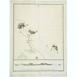
Port de Touran. . .
A large sea chart produced and published by the Depot General de la Marine in Paris. It shows the Port of Touran (modern day Da Nang) in Vietnam. Located on the coast of ...
- $500 / ≈ €468
Place & Date: Paris, ca 1830