Browse Listings in Asia > Tartary / Siberia
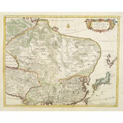
Tabula Tartariae et majoris partis regni Chinae.
Stretching from the Caspian Sea in the west to Formosa in the south-east. Including the peninsula of Korea, Japan and the east coast of Yedso. The Great Wall of China is ...
- $650 / ≈ €608
Place & Date: Amsterdam, 1680

Noordoost Cust van Asia van Japan tot Nova Zembla.
Important for its early depiction of Hokkaido and the Islands to the North of Japan. Ships navigate the seas around the Siberian, Chinese and Japanese coast extending as ...
- $3000 / ≈ €2807
Place & Date: Amsterdam, 1666

Carte des parties Nord et est de l'Asie.. (5 maps on one sheet)
Five maps on one sheet, showing California, Alaska and Syberia, Korea and Japan. South to Korea the island "Quelpaerts".The map is from Diderot's "Encyclop...
- $200 / ≈ €187
Place & Date: Paris, 1772
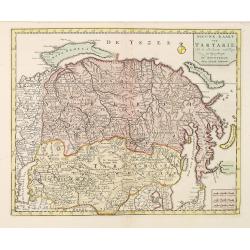
Nieuwe kaart van Tartarie.
A map of Tartary, Korea and part of Japan. The map is most notable for the confusion between Kamchatka and Iesso.Engraved by J.Keyser in 1731.
- $250 / ≈ €234
Place & Date: Amsterdam, 1731 / 1750
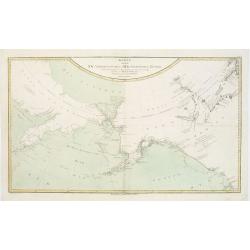
Karte von den N.W. Amerikanischen und N.OE. Asiatischen Kusten nach den Untersuchungen des Kapit. Cook...
A detailed large-scale map showing the Bering Strait, Kamchatka, Alaska and much of North America. While the Russian coastline is shown with reasonable accuracy. Showin...
- $450 / ≈ €421
Place & Date: Vienna, 1788
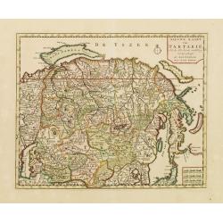
Nieuwe kaart van Tartarie.
A map of Tartary, Korea and part of Japan. The map is most notable for the confusion between Kamchatka and Iesso. Hokaido labelled Compagnie LandFrom: Nieuwe en Beknopte ...
- $450 / ≈ €421
Place & Date: Amsterdam 1750
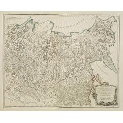
Partie Orientale de l'Empire de Russie en Asie.
Detailed map of the north-eastern part of Russia, including Siberia.
- $400 / ≈ €374
Place & Date: Paris 1752

Noordoost Cust van Asia van Japan tot Nova Zemla.
An eye-catching chart of Japan, Hokkaido and the Islands to the North of Japan. In the lower left Korea and part of northern China. Korea has three names mentioned: "...
- $2000 / ≈ €1871
Place & Date: Amsterdam, 1666
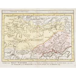
Carte de la Tartarie Occidentale.
Uncommon issue of this finely engraved map showing China's capital city of Peking inland from the Gulf of Lyau-tong. The map locates northeastern China to the border of R...
- $150 / ≈ €140
Place & Date: Amsterdam, 1749

Impery sino Tartarici Supremus Monarcha.
Decorative costume plate showing Kam Hi son of the Shunzhi Emperor of China [1638 - 1661?], the second emperor of the Manchu Qing dynasty, who apparently supported the fo...
Place & Date: Amsterdam, 1668