Search Listings matching "silk" in Asia > Tartary / Siberia
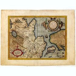
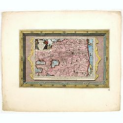
Tartariae sive Magni Chami Imperium.
This is a very early depiction of the northern Pacific, with the first mapping of the Northwest Coast of America and probably the first map to name California 'C. Califor...
- $1750 / ≈ €1496
Place & Date: Antwerp, c. 1590

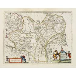
Tartaria.
Published in Hondius' editions of the Mercator Atlas from 1606 onwards, China, Korea, and the northern Pacific coast of America are shown as two continents separated by t...
Place & Date: Amsterdam, 1633
Tartaria sive Magni Chami imperium.
This is a detailed and decorative map of the Tartary and northern part of China, including the Chinese Great Wall, the Caspian Sea, and the Volga River east as far as the...
- $700 / ≈ €598
Place & Date: Amsterdam, 1658
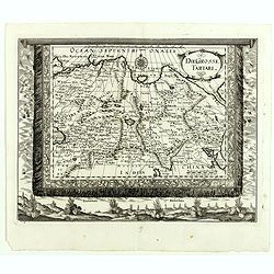
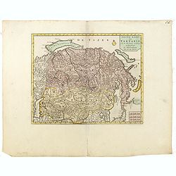
Die Grosse Tartari.
Rare map showing Siberia, Korea with part of the Caspian Sea to the West, as well as India and North Russia. The title in an oval cartouche in upper right cornerThe map r...
- $1000 / ≈ €855
Place & Date: Augsburg, 1689
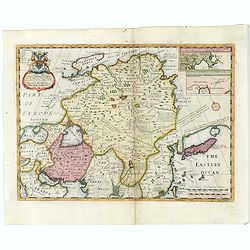
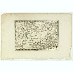
A New Map of Great Tartary and China with the adjoining parts of Asia
Two insets show the land to the northeast of China, according to Jesuit information. The map stretches from northern Russia and Nova Zemlya in the northwest to Formosa in...
Place & Date: Oxford, 1700
Historic Map - Naaukeurige Kaart Van Tartaryen, Soo als dat door W De Rubruquis doorreyst.
This attractive map published by Pieter van der Aa, shows Tartary abd the ancient Silk Road region. The map shows the track of William of Rubruck (Willem van Rubroeck or ...
Place & Date: Amsterdam, 1713-1729
A Map of Western Tartary Drawn from the Survey of the Jesuits and Mr. Kyrillow's Map of the Russian Empire.
Uncommon map of the Gobi Desert and the eastern portion of the Silk Route region by Thomas Kitchin. Covers from Lake Baikal in the north as far south as Beijing, east to ...
- $110 / ≈ €94
Place & Date: London, 1745-1747
Nieuwe kaart van Tartarie.
A map of Tartary, Korea and part of Japan. The map is most notable for the confusion between Kamchatka and Iesso.There are very good details of towns and trade routes in ...
Place & Date: Amsterdam, 1750
![Une Kirguisiene par devant. [together with] Une Kirguisienne par derriere.](/uploads/cache/32991-250x250.jpg)
Une Kirguisiene par devant. [together with] Une Kirguisienne par derriere.
Uncommon copper-engraved costume plate showing two natives of Kyrgyzstan, a Central Asian country along the Silk Road, the ancient trade route between China and the Medit...
Place & Date: St. Petersbourg, C.G. Müller, 1776-1780

Kirguisienne.
Originally hand-colored mezzotint from 'Costumes civils actuels de tous les peuples connus', showing a native of Kyrgyzstan, a Central Asian country along the Silk Road, ...
- $25 / ≈ €21
Place & Date: Paris,1801-1806
![[Isothermal Linti].](/uploads/cache/46152-250x250.jpg)