Search Listings matching "silk" in Asia > Persia / Armenia / Iran / Irak
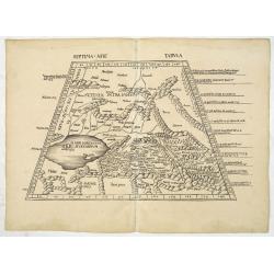
Septima Asie Tabula (Central Asia.)
A woodblock-printed large-format Ptolemaic map showing the region east of the Caspian Sea is labeled SOGDIANA. Sogdia or Sogdiana was an ancient Iranian civilization betw...
Place & Date: Strasburg, 1513
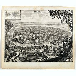
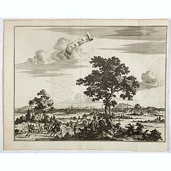
Isfahan.
An early of Isfahan in central Iran,. From the rare first edition "Offt begehrte Beschreibung der newen orientalischen Rejse, so durch Gelegenheit einer Holsteinisc...
- $250 / ≈ €214
Place & Date: Schleßwig, Zur Glocken, 1647
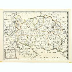
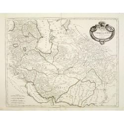
Description de l'Empire du Sophi des Perses tiree en partie de l'Arabe de Nubie, et en partie de plusieurs et diverses Relations.
The map of the Empire of Persia is shown to extend from Baghdad almost to the present-day borders of India. Including part of Saudi Arabia and Oman. Including "Golfe...
Place & Date: Paris, 1650
![Nouvelle carte de la province de Kilan en Persie . . . (Iran]](/uploads/cache/39437-250x250.jpg)
Nouvelle carte de la province de Kilan en Persie . . . (Iran]
Decorative map of southern part of the Caspian Sea in Northern Iran. This well executed engraving was published in 1729 and 1727 by Pieter van der AA, in Leiden in "...
- $300 / ≈ €256
Place & Date: Leiden, 1719
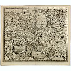
Carte la plus nouvelle et plus exacte du royaume de Perse . . .
This is a decorative map of Persia and Central Asia. It has very good details of the region east of the Caspian Sea, showing modern-day Uzbekistan. The region is labeled ...
- $400 / ≈ €342
Place & Date: Leiden, 1719
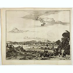
Saba, ville en Perse.
Decorative view of Sabā / Dakān Sorkh) which is a village in Vahdatiyeh Rural District in present-day Iran.In the foreground are camels and horses. This well-executed e...
Place & Date: Leiden, 1719
La grande & belle ville de Kaschan, en Perse. (Kashan in Iran)
Decorative view of Kashan in Iran. A branch of the Silk Road skirts the western and southern edges of Iran's central desert, passing through a string of small cities — ...
- $300 / ≈ €256
Place & Date: Leiden, 1719
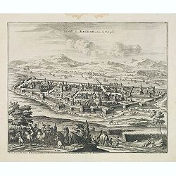
La Ville de Bagdad, dans la Turquie.
Decorative view of the town of Bagdad. This well executed engraving was published in 1729 and 1727 by Pieter van der AA, in Leiden in "Voyages tres-curieux et tres-r...
- $350 / ≈ €299
Place & Date: Leiden, 1719-1727
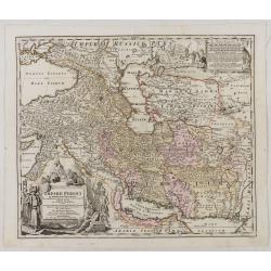
Imperii Persici in omnes suas Provincias . . . Exacte Divisi Nova Tabula Geographica. . .
Showing the eastern part of Turkey and Cyprus, Palestine, Persian Gulf, including Gulf of Oman, Caspian Sea, Iran and the north-west territories of India.Embellished with...
Place & Date: Ausburg, 1730
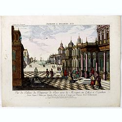
Vue du Pallais du l'Empereur de Perse avec la Mosquée, ou Eglise a Ispahan.
An optical print of the court of the Persian Emperor. Engraved by F.X. Habermann (1721-1796). The Academie Imperiale was a well-known publisher of optical prints, establi...
- $300 / ≈ €256
Place & Date: Augsburg, 1750
![[Set of 3 optical prints] Vue du Pallais du l'Empereur de Perse avec la Mosquée, ou Eglise a Ispahan.](/uploads/cache/49123-250x250.jpg)
[Set of 3 optical prints] Vue du Pallais du l'Empereur de Perse avec la Mosquée, ou Eglise a Ispahan.
An optical print of the court of the Persian Emperor. Engraved by F.X. Habermann (1721-1796). The Academie Imperiale was a well-known publisher of optical prints establis...
Place & Date: Augsburg, 1750
Perse.
Scarce small map of Persia based on cartography of Guillaume Delisle (. Published in "Nouveau traité de geographie par M ", published by La veuve Lottin & ...
Place & Date: Paris, P.G. Le Mercier, 1752
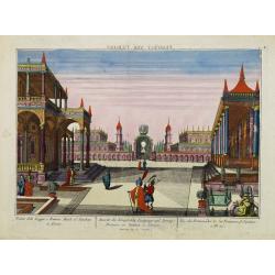
Vue des Promenades et les Fontaines d'Ispahan.
Carmine was a well-known publisher of optical prints, established in Augsburg.Isfahan was once one of Central Asia's largest and most important cities, at the crossroads ...
Place & Date: Augsburg 1770
Le Royaume de Perse suivant les nouvelles observations Par J.B.Nolin.
This is a rare map of Persia with modern-day Uzbekistan to the north. The region is labeled as "Grande Tartarie" and "Pays des Usbeks." Bocara (Bukhar...
- $300 / ≈ €256
Place & Date: Paris, 1783
Carte de l'Empire de Perse...
Finely and crisply engraved map of the Persian Empire during the 18th century. It shows the Caspian Sea in the north to the Persian Gulf in the south, and from Armenia in...
Place & Date: Venice, 1779 - 1784
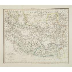
Perse Afghanistan et Balouchistan . . .
Detailed map of Irak and Iran, prepared by A. H. Basset, rue Saint-Jacques, no. 64, Paris and published in Atlas classique et Universel de Géographie . . . .The top thre...
Place & Date: Paris, A.H. Basset, 1828