Browse Listings in Asia > Near / Middle East
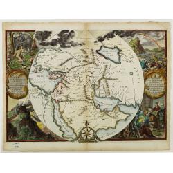
Orbis Per Creationem Institutus.
This is a very unusual map depicting the region from Asia Minor to India and including all of the Arabian Peninsula within a circle. The Garden of Eden is prominently dis...
Place & Date: Amsterdam, 1700
Selling price: $650
Sold in 2019
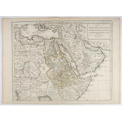
Carte de L'Egypte de la Nubiede L'Abissinie. . .
Including the Arabian Peninsula. Giving good detail on Egypt. Engraved by Desrosiers.More about Mapping of Arabia [+]
- $300 / ≈ €281
Place & Date: Paris, 1707
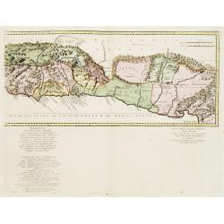
Cilicia Asiae Minoris pars orientalis. . .
Uncommon map of Cilicia, an ancient region and former kingdom of SE Asia Minor, between the Taurus Mountains and the Mediterranean: corresponds to the region around prese...
- $200 / ≈ €187
Place & Date: Paris/ Bordeaux, 1726
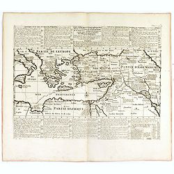
Carte historique et géographique pour servir à l'Histoire Sainte et à la Vocation de Saint Paul, avec quelques remarques curieuses pour servir à l'Histoire des Antiquités judaïques.
Interesting sheet with a map of the travels of Saint Paul, including eastern part of Europe, Asian continent and part of north Africa, with descriptive French text, from ...
Place & Date: Amsterdam, 1728
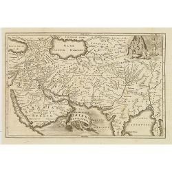
Oriens, Persia, India etc.
Uncommon map of Persia, Armenia, Arabian Peninsular and part of India. Prepared by Christoph Cellarius (1638-1707). From Geographia Antiqua...
- $100 / ≈ €94
Place & Date: Leipzig, Gledisch, 1732
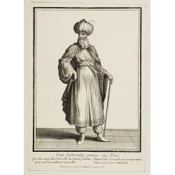
Emir Fechrredin prince des Drus.
Engraving published by Nicolas Bonnart (c.1637 - 1718), engraver in Augsburg since 1719. Before the nineteenth century portraits of rulers in the Islamic Middle East were...
Place & Date: Paris, ca. 1740

Carte de la Turquie, de l'Arabie et de la Perse..
Large map of the Near East, based upon earlier maps by De L'Isle. Shows also most part of the Mediterranean basin as well as north-eastern Africa. Relief shown pictoriall...
Place & Date: Amsterdam c. 1745
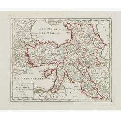
Turquie Asiatique..
Small detailed map of the Near East, including Cyprus, the Black Sea and Georgie. From Atlas Portatif Universel, by Robert de Vaugondy.Page 65 outside border top right. M...
- $100 / ≈ €94
Place & Date: Paris, later than 1748
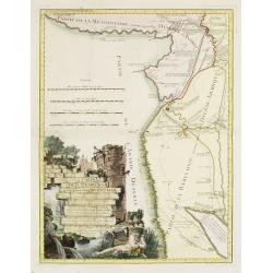
Carte de la Babylonie nommée aujourd'hui Hierac-Arab avec les noms, tant anciens que modernes et les routes des expéditions de Cyrus et de Julien l'Apostat, aussi bien que celles de Teixera, Benjamin. . .
A very fine map centered on Arabia and in top Iraq with Baghdad. With a very attractive title cartouche on the lower left-hand corner. Published by Joseph-Nicolas De l' I...
- $550 / ≈ €515
Place & Date: Paris/ Bordeaux, 1766
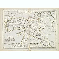
Carte de la retraite des dix mille. . .
Ancient map of Near and Middle East, including Cyprus, prepared by Nolin and published by L.J. Mondhare for his Atlas Général a l'usage des colleges et maisons d'educat...
- $50 / ≈ €47
Place & Date: Paris, 1781