Search Listings matching "east-sea" in Asia > Korea (and Japan)

Asia carta di ciasete piu moderna. (Japan)
Rare FIRST STATE of this important map for Korea and Japan map of the Blancus/Moreira type, but adds a huge 'Jesso' filling the top of this old map. The map is of interes...
Place & Date: Florence, 1646-1647

Isola del Giapone e penisola di Corea.
A most attractive and decorative map by Vincenzo Coronelli. An elaborate central title cartouche garlanded with intertwined flowers and dedicated to the Rev.de Fontaine o...
Place & Date: Venice, 1692
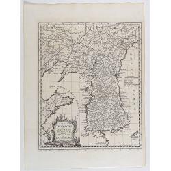
A map of Quan-Tong or Lyau-Tong province, and the kingdom of Kau-Li or Korea . . .
Detailed map of Korea, Liaodong, and the tip of Shandong Province prepared by Thomas Kitchin for Thomas Salmon's Universal Traveller, based on D'Anville's landmark map of...
Place & Date: London, 1747
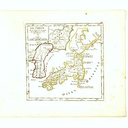
Le Japon Par le Sr. Robert de Vaugondy fils de Mr. Robert Geog. Ord du Roi avec Privilege 1749.
Small detailed map of Japan and Korea. From Atlas Portatif Universel, by Robert de Vaugondy.Page 168 outside border top right. First state. The map is of interest for the...
Place & Date: Paris, 1749

Carte du Katay ou Empire de Kin. . .
The map is of interest for the use of Mer de Corée for the sea between Korea and Japan .Fine map of Korea and China's Yellow Sea. Complete title in top: Carte du Katay o...
Place & Date: Paris, 1750

Karte von Katay od. dem Reiche Kin, zur Geschichte von Jenghiz Khan. Aus dem Englischen.
The map is of interest for the use of East Sea, the sea between Korea and Japan, here called "Meer von Corea".Copper engraving, hand colored in outline and wash...
Place & Date: Leipzig, Schwabe, ca. 1750
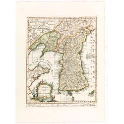
Carte de la province de Quan-tong, ou Lyau-tong et du Royaume de Kau-li ou Corée. . . / Kaart van t' Landschap Quan-Tong . . .
Uncommon issue of this fine map of Korea. The map is of interest for the use of East Sea, the sea between Korea and Japan, here called "Mer de Corée.Decorative titl...
Place & Date: Paris, 1749-1773

NEWTON'S New and Improved TERRESTRIAL GLOBE Accurately delineated from the observations of the most esteemed NAVIGATORS AND TRAVELLERS to the Present Time. . .
A very impressive Victorian 20-inch Library globe is showing the "Gulf of Corea."On an exceptionally carved mahogany tripod stand with scrolling acanthus legs t...
Place & Date: London, January 1, 1867