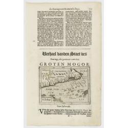
Malabar.
Small map illustrating the southwestern sea coast of India. Oriented with East on top, surrounded by text in Dutch.Included in the rare book : Wereld Spiegel, waer in ver...
- $200 / ≈ €175
Place & Date: Amsterdam, Cloppenburch, 1621
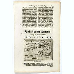
Malabar.
Small map illustrating the south western seacoast of India. Oriented with East on top, surrounded by text in Dutch.Nicolaes de Clerck (de Klerc) was active as engraver an...
- $175 / ≈ €153
Place & Date: Amsterdam, Cloppenburch, 1621
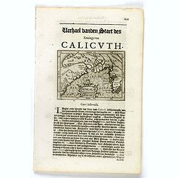
Bengala.
Small map centered on the Bay of Bengal, surrounded by text in Dutch. Nicolaes de Clerck (de Klerc) was active as engraver and publisher in Delft from 1599-1621.Included ...
- $150 / ≈ €131
Place & Date: Amsterdam, Cloppenburch, 1621
![Narsinga. [India]](/uploads/cache/38123-250x250.jpg)
Narsinga. [India]
Small map illustrating the Indian peninsular. Oriented with East on top, surrounded by text in Dutch.Nicolaes de Clerck (de Klerc) was active as engraver and publisher in...
- $225 / ≈ €197
Place & Date: Amsterdam, Cloppenburch, 1621
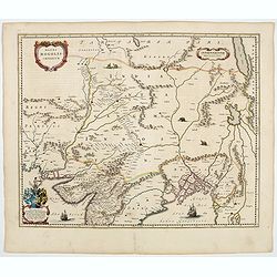
Magni Mogolis Imperium.
An attractive map of the region from Iran through Afghanistan, Tibet, and northern India across to Burma. The travel route from Kabul to Surat is the most prominent featu...
- $350 / ≈ €307
Place & Date: Amsterdam, 1644
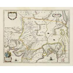
Magni Mogolis Imperium.
An attractive map of the northern part of India, Tibet, Iran to Burma. The travel route from Kabul to Surat is the most prominent feature of the map. Richly decorated wit...
- $650 / ≈ €569
Place & Date: Amsterdam, 1658