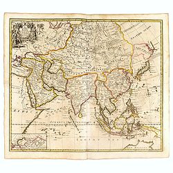
A New Map of Asia from the latest Observations Most Humbly Inscrib'd to the Right Honbl. George Earl of Warrington &c.
Fine map of Asia, with decorative title cartouche flanked by two figures in Asian dress, along with flora and fauna of the continent., based on the work of Guillaume De L...
Place & Date: London, 1721

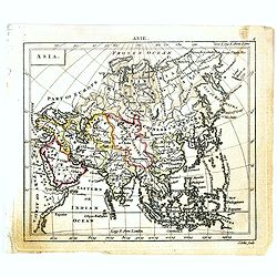
L'Asie suivant les nouvelles observations...
Uncommon edition of this map of Asia. From Le Nouveau Theatre du Monde, ou la Geographie Royale.The map is of interest for the use of Mer Orientale, the sea between Kor...
Place & Date: Amsterdam, 1728

Asia By H.Moll Geographer.
Detailed map of Asia. From his "Atlas minor: or a new and curious set of sixty-two maps. . .", which was first published in 1729 and reprinted in 1732, 1736.The...
Place & Date: London, 1736

Kaartje van Asia. . .
Attractive and rare map of Asia. From Atlas Portatif . With a curious and oversized Hokkaido. The map is of interest for the use of Coreanse Zee for the sea between Korea...
Place & Date: Deventer 1742

Kaartje van Asia. . .
Attractive and rare map of Asia. From Atlas Portatif . With a curious and oversized Hokkaido. The map is of interest for the use of Corease Zee for the sea between Korea ...
Place & Date: Deventer, 1742

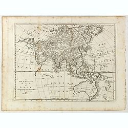
Asia secundum legitimas projectionis stereographicae.
Highlighted area covers part of Spain, eastern coast of Ireland to western part of Papua New Guinea and the Asian continent from the Northern Polar Sea to the Indian Ocea...
Place & Date: Nurenberg, 1744
Asia.
Uncommon miniature map of Asia. The map is of interest for the use of Sea of Corea, for the sea between Korea and Japan.Engraved by J.Ellis for "A New General and Un...
- $150 / ≈ €128
Place & Date: London, 1761-1763
A new & accurate map of Asia, Drawn from the most approved modern maps & charts / by Thos. Bowen.
The map is of interest for the use of Sea of Korea for the sea between Korea and Japan.Detailed map of Asia from Saudi Arabia, Persia, Russia, India, China, Japan to Sout...
- $900 / ≈ €769
Place & Date: London, J.Cooke, 1777-1778

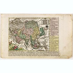
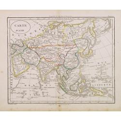
L'Asie divisée en ses principaux Etats..
A finely and crisply engraved map of Asia is decorated with an ornamental title cartouche in the lower-left corner.There are very good details of towns in modern-day Uzbe...
Place & Date: Venice, 1776 - 1784
![A New and Correct Map of Asia Laid down from the latest and best Observations Humbly Inscribed to his Royal Highness George, Prince of Wales. . . [2 subtitles:] Several Representations of the Customs Manners etc. of Divers Parts of Asia. . .](/uploads/cache/35765-250x250.jpg)
A New and Correct Map of Asia Laid down from the latest and best Observations Humbly Inscribed to his Royal Highness George, Prince of Wales. . . [2 subtitles:] Several Representations of the Customs Manners etc. of Divers Parts of Asia. . .
A large, attractive and rare, separately issued map of Asia with figured side borders. With large decorative title cartouche ad address "By Thomas Kitchin. London, p...
Place & Date: London, 1787

Carte d'Asie divisée en ses principaux Etats.
Uncommon and decorative "carte à figures" - wall map, prepared by Clouet, with superb decoration, including a wonderful rococo border with 20 decorative vignet...
Place & Date: Paris, Mondhare, 1787
Asia verlegt von Ioh Mich Probst.
Uncommon map of Asia, with an explanatory text and directory on the right and the bottom of the map from the "Atlas Minor ex Tabulis Geographicis ".The map is o...
- $300 / ≈ €256
Place & Date: Augsburg, 1789
Asia.
The map is of interest for the use of Gulf of Corea, the sea between Korea and Japan.William Darton, Sr. started his mapmaking business in 1787 in London, and thus began ...
- $300 / ≈ €256
Place & Date: London, 1802
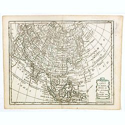
Carte d'Asie . . .
Map of the Asian continent, from Atlas moderne portatif composé de vingt-huit cartes sur toutes les parties du globe terrestre .. A l'usage des Colléges, des Pensions &...
- $230 / ≈ €197
Place & Date: Paris, Prudhomme, Levrault, Debray, 1806

Asia.
Uncommon map of Asia. Engraved by Marco di Pietro.The map is of interest for the use of G. di Corea, for the sea between Korea and Japan.Published by Carlo Antonio Barbie...
Place & Date: Milan, 1807
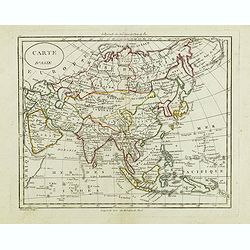
Carte d'Asie.
Fine map of Asia, with an interesting representations of Japan, Hokkaido, Sakhalin Island, Kamchatka and Korea. Engraved by Alexandre Blondeau, who also worked for Depôt...
- $150 / ≈ €128
Place & Date: Paris, c. 1810
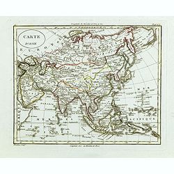
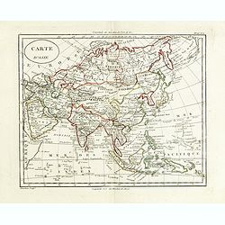
Carte d'Asie.
Fine map of Asia, with an interesting representation of Japan, Hokkaido, Sakhalin Island, Kamchatka, and Korea. Engraved by Alexandre Blondeau, who also worked for Depôt...
- $175 / ≈ €150
Place & Date: Paris, c. 1810
Carte d'Asie.
Fine map of Asia, with an interesting representations of Japan, Hokkaido, Sakhalin Island, Kamchatka and Korea. Engraved by Alexandre Blondeau, who also worked for Depôt...
- $150 / ≈ €128
Place & Date: Paris, c. 1810
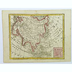
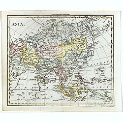
L'Asia...
A small, uncomplicated map of Asia with outline coloring. Map extends down from the Arctic Circle to Java and New Guinea. From Arabia in the west to Japan in the east.Sma...
- $175 / ≈ €150
Place & Date: Venezia, 1810
Carte d'Asie.
Fine map of Asia, with an interesting representations of Japan, Hokkaido, Sakhalin Island, Kamchatka and Korea. Engraved by Alexandre Blondeau, who also worked for Depot ...
- $150 / ≈ €128
Place & Date: Paris, c. 1810
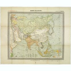
General Karte von Asien. Entworfen und gezeichnet von F. Handtke.
In upper left corner "Carl Flemmings Generalkarten No. / Nr. 37" in a 17th edition. Prepared by Friedrich Handtke (1815-1879). Scale 1: 18.886.000, with a key i...
Place & Date: Glogau, Carl Flemming, c.1910