![[LXXXI. Amida e Xaca ].](/uploads/cache/34985-250x250.jpg)
[LXXXI. Amida e Xaca ].
Aquatint depicting Amida (or Amideva who is a celestial Buddha) and the God Xaca, engraved by A.Rancati. Plate N°81.From Giulio Ferrario's work Le Costume Ancien et Mode...
- $40 / ≈ €37
Place & Date: Milan, 1827
![[XIX. Principali persone componenti la marcia ec..].](/uploads/cache/34986-250x250.jpg)
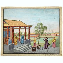
[XIX. Principali persone componenti la marcia ec..].
Aquatint depicting a Chinese procession, engraved by G. Zacon, Plate N°16.From Giulio Ferrario's work Le Costume Ancien et Moderne ou Histoire du gouvernement, de la mil...
- $50 / ≈ €47
Place & Date: Milan, 1827
![[LXXXIII. Nozze].](/uploads/cache/34987-250x250.jpg)
[LXXXIII. Nozze].
Aquatint depicting a Chinese wedding ceremony engraved by A. Rancati, Plate N°83.From Giulio Ferrario's work Le Costume Ancien et Moderne ou Histoire du gouvernement, de...
- $50 / ≈ €47
Place & Date: Milan, 1827
![[Antico Imperatore nel suo carro].](/uploads/cache/34990-250x250.jpg)
[Antico Imperatore nel suo carro].
Aquatint depicting an Emperor in his chariot engraved by G. Bigatti, Plate N°13.From Giulio Ferrario's work Le Costume Ancien et Moderne ou Histoire du gouvernement, de ...
- $50 / ≈ €47
Place & Date: Milan, 1827
![[LXVIII. Abiti de' cittadini e de' contadini].](/uploads/cache/34991-250x250.jpg)
[LXVIII. Abiti de' cittadini e de' contadini].
Aquatint costume plate showing Chinese citizens and farmers engraved by G. Bigatti, Plate N°68.From Giulio Ferrario's work Le Costume Ancien et Moderne ou Histoire du go...
- $50 / ≈ €47
Place & Date: Milan, 1827
![[XXXII. Dio Quante-Cong].](/uploads/cache/34992-250x250.jpg)
[XXXII. Dio Quante-Cong].
Aquatint depicting Chinese Idol Quantecong, who was the first Emperor, engraved by G Zancon, Plate N°32.From Giulio Ferrario's work Le Costume Ancien et Moderne ou Histo...
- $50 / ≈ €47
Place & Date: Milan, 1827
![[XL. Sepolcro di un Grande].](/uploads/cache/34993-250x250.jpg)
[XL. Sepolcro di un Grande].
Aquatint depicting the tomb engraved by L. Rolsi. Plate N°40.From Giulio Ferrario's work Le Costume Ancien et Moderne ou Histoire du gouvernement, de la milice, de la re...
- $40 / ≈ €37
Place & Date: Milan, 1827
![[View of Castle and Bridge Vandipore - Bhutan - Tibet ]](/uploads/cache/34997-250x250.jpg)
[View of Castle and Bridge Vandipore - Bhutan - Tibet ]
Aquatint print with view of Castle and Bridge Vandipore - Bhutan - Tibet engraved by G. Castellini. Plate N°7.From Giulio Ferrario's work Le Costume Ancien et Moderne ou...
- $75 / ≈ €70
Place & Date: Milan, 1827
![[8 sheets - Partie du THIBET]](/uploads/cache/36629-250x250.jpg)
[8 sheets - Partie du THIBET]
A set of 8 maps covering Tibet region and the Himalayas.From his famous Atlas Universel . This atlas was one of the most remarkable world atlases ever produced, anticipat...
- $1000 / ≈ €936
Place & Date: Brussels, 1825-1827
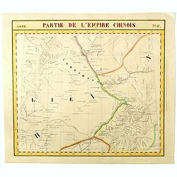
Partie de L'Empire Chinois - No.47.
One of Vandermaelen's 378 conjoined maps on a uniform scale to made up the total globe. This map features the Eastern Mongolia portion of China with Oloa Baytin. Interest...
- $75 / ≈ €70
Place & Date: Brussels, 1825-1827
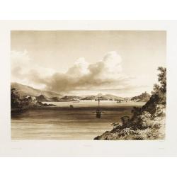
Macao.
Early view of Macao after Barthelemy Lauvergne (1805-1875) and engraved in aquatint technique by Sigismond Himely (1801-1872). Published as plate 28 in Voyage autour du m...
- $600 / ≈ €561
Place & Date: Paris, Finot, 1835
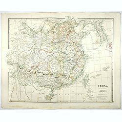
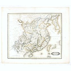
China.
Map of China, Taiwan and Korea. This map by the nephew of Aaron Arrowsmith first appeared in 1832 and was reissued several times. The present issue appeared in Arrowsmith...
Place & Date: London, 1838
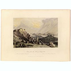
Macao from the Forts of Heang-shan.
A finely delineated view of the city of Macao as seen from one of its fortification areas. The foreground contains a group of religious worshipers. Engraved by S. Fisher....
- $150 / ≈ €140
Place & Date: London, ca. 1840
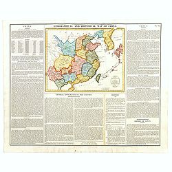
Geographical and Statistical Map of China. China and the Tributary Kingdom of Corea. For the Elucidation of Lavoisne's Genealogical, Historical, Chronological, & Geographical Atlas, by C. Gros, 1820. No. 64. Revised 1828.
Fine map of China and Korea, with a sub-title in top "Geographical and historical map of China.". The map is apparently a revised edition for 1828.The atlas was...
- $450 / ≈ €421
Place & Date: London, 1842
China.
This detailed map of China includes text giving measurements of "The Great Chinese Wall".The map was published in "Lizars' Edinburgh Geographical General A...
- $300 / ≈ €281
Place & Date: Edinburg, 1842
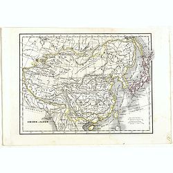
Chine et Japon.
Detailed map of China, Korea, Taiwan and Japan, prepared by Charles V. Monin (fl.1830-1880) a French cartographer of Caen and Paris. Published in Atlas Universel de Géog...
- $75 / ≈ €70
Place & Date: Paris, 1845
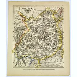
China-Propria oder das eigentliche China.
Map number 48 from Meyer's 'Zeitung's Atlas', a popular German 'pocket atlas', published during the mid nineteenth century. This map of China shows the mainland, and the ...
Place & Date: Hildburghausen / Philadelphia, 1849
Chinese Export watercolor.
Chinese watercolor with in lower margin Chinese text : Chinese watercolor - " A farmer's thief, a book, a big manuscipt, a filial piety, a martial art. " [Googl...
- $1000 / ≈ €936
Place & Date: China, ca. 1850
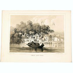
Chinese Temple, Macao.
A pleasant view of the important Chinese Temple in Macao, taken from the water with a junk in the foreground and many sampans and junks moored in front of it, with visito...
- $75 / ≈ €70
Place & Date: Philadelphia, 1856
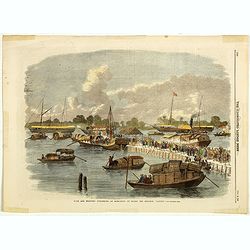
Sick and wounded embarking at Hong-Kong on Board the Steamer.
Large view of the harbour with numerous ships and people. From the Illustrated London News, October 23, 1858.
- $75 / ≈ €70
Place & Date: London, October 1858
La Cina propriamente detta e sue isole.
Uncommon map of China prepared by Francesco Costantino Marmocchi. Above the map "Geografia Commerciale". From "Il Globo Atlante di carte Geografiche compil...
Place & Date: Genova, Paolo Rivara fu Giacomo, 1858
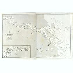
China, Sheet IX, Yang-Tse-Kiang from the sea to Nanking . . .
A fine, large-scale chart. This chart depicts the last stretch of the Yangtse River before it meets the sea. It gives soundings and notes on the tides, and includes an in...
- $750 / ≈ €702
Place & Date: London, 1843-1859
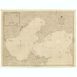
China east coast Yellow Sea and Gulf of Pechili
Very detailed chart of China's east coast with the Yellow Sea and Gulf of Pechili. Scale: circa 1:1m. Inscription: J & C Walker sculpt. One inset: Pekin to the Gulf o...
- $450 / ≈ €421
Place & Date: London, 1840 - 1859

A fan combining views of Hong Kong (right), Canton (center), and Macau.
The fan shows nice images of Macau, Hong Kong and Canton on onside and on verso a garden with 45 characters welcoming a rider on his white horse. Their clothes are height...
Place & Date: China, ca. 1850-1860
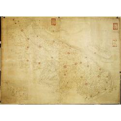
Militairy manuscript map of the end of Yangzi River across Shanghai, Jiangsu, and Zhejiang areas, with 3 red seals of the Ever-Victorious Army.
In lower left corner an inset plan of Songjiang District with Shanghai with a grid and the area is divided with red doted border lines.The map has three red seals of the ...
Place & Date: China, ca 1862
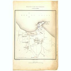
Plan de Camp de Tché-Fou et de ses environs.
A rare and detailed plan of Chefoo, which was a treaty port in Shantung province, near today's Yantai. Plate IV from "Atlas de l'expédition de Chine en 1860: rédig...
- $300 / ≈ €281
Place & Date: Paris, 1862
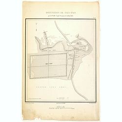
Occupation de Tien-Tsin par la Flottille Anglo-Française le 26 Mai 1859.
Plate III from "Atlas de l'expédition de Chine en 1860: rédigé au dépôt de la guerre d'après les documents officiels, étant directeur le général Blondel, so...
- $250 / ≈ €234
Place & Date: Paris, 1862
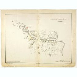
Combat de Tchang-Ki-Ouang 18 septembre 1860.
Plate VI from "Atlas de l'expédition de Chine en 1860: rédigé au dépôt de la guerre d'après les documents officiels, étant directeur le général Blondel, sou...
Place & Date: Paris, 1862

Plan de la rade de Macao (chine) Levé d'après les ordres mr. Rocquemaurel.
Very detailed chart of Macao and several of the surrounding Islands, and features numerous depth soundings throughout. Prepared by captain, Gaston de Rocquemaurel. Logo o...
Place & Date: Paris, c.1856 / 1863
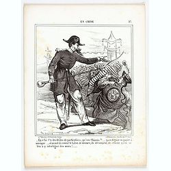
En Chine.
From the series "Caricatures du Prussien - Guerre des Duchés". Lithographed by Julés Pelcoq.
Place & Date: Paris, 1864
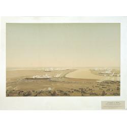
Attaque & prise des forts du Pei-Ho Le 21 Août 1860, par les troupes Françaises et Anglaises.
In 1860, an Anglo-French force gathered at Hong Kong and then carried out a landing at Pei Tang on August 1, and a successful assault on the Taku Forts on August 21.This ...
- $500 / ≈ €468
Place & Date: Paris, ca.1865

Carte du Kouy-Tchéou.
Detailed map of Guizhou Province prepared by Mgr. Faurie and other sources supplied by missionaries. Published in "Les Missions Catholique". Engraved by P. Méa...
Place & Date: Lyon, c.1874
![Carte du Tche-Kiang. [ Zhejiang province ]](/uploads/cache/30921-250x250.jpg)
Carte du Tche-Kiang. [ Zhejiang province ]
Map of Tche Kiang, prepared by Bishop Edmond-François Guierry, C.M. (Vicar Apostolic of Zhejiang, China) after sources supplied by missionaries. Published in "Les M...
Place & Date: Paris, 1874
![Hong Kong. [Queen's Road]](/uploads/cache/24362-250x250.jpg)
Hong Kong. [Queen's Road]
Finely executed watercolor made by Henri Dieth of a charming atmospheric street scene at Queen's Road in Hong Kong. The watercolor is made after Eduard Hildebrandt (1818-...
Place & Date: Germany, 1882
![Hongkong Piratenstrasse. [Pirate Street]](/uploads/cache/24363-250x250.jpg)
Hongkong Piratenstrasse. [Pirate Street]
Finely executed watercolor made by Henri Dieth of a charming street scene at "Pirate Street" in Hong Kong. The watercolor is made after Eduard Hildebrandt (1818...
Place & Date: Germany, 1882

Runde Strasse in Peking.
Finely executed water color made by Henri Dieth of a charming street scene in Peking. The water color is made after Eduard Hildebrandt (1818-1869). Hildebrandt, was born ...
Place & Date: Germany, 1882
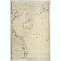
China Sea Nothern Porton compiled from the latest survey to 1884
A fine Survey chart no. 2680 showing Tong King Gulf, Hanan Island up to Hong Kong, Macao and Canto River up to Canton (Being)
- $800 / ≈ €749
Place & Date: London, 1887, updated to 1897
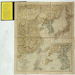
Stanford's Map of Eastern China, Japan and Korea. 1898.
Charming, folding map of the east coast of China, Korea and Japan. In the lower right corner inset map of Korea (265x512mm.). In the lower left, a key to Treaty Ports, Su...
- $750 / ≈ €702
Place & Date: London, ca. 1898
![Nankin [Nanjing, Jiangsu]](/uploads/cache/30031-250x250.jpg)
Nankin [Nanjing, Jiangsu]
Very detailed (1:1.000.000) map showing the area north of Nanjing, Jiangsu. The French Service géographique des armées was founded in 1887 and provided the French milit...
Place & Date: Paris, 1900
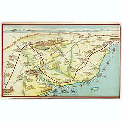
Peking. ( Pictorial map)
This pictorial map of this Game of the Goose, published at the time of the Boxer War, shows well the situation of Pei-Ho and Tientsin in relation to Peking. There are 42 ...
- $600 / ≈ €561
Place & Date: France, ca.1901